![]()
Prev Page--Utilization, Quality || Next Page--Bibliography
Geologic Formations and their Water-bearing Properties
Permian System
The oldest rocks encountered by deep drilling in the county belong to the Permian system. They do not crop out in the county and only one hole has been drilled deep enough to penetrate these beds—a gas test well drilled to a depth of 3,005 feet by the Western Production Company in the middle of the NE sec. 11, T. 29 S., R. 41 W. (log 22).
The material from a depth of 880 feet to the bottom of the hole is here assigned to the Permian system. These rocks at a depth of 880 to 2,200 feet are principally red shales, but there are minor amounts of anhydrite, gypsum, and limestone; the rocks from 2,200 feet to the bottom of the hole consist mainly of limestone and hard blue shale, but also include in the upper part, beds of anhydrite and gypsum. No attempt is here made to differentiate these rocks into smaller geologic divisions, owing to the lack of detail in the log. An oil well in sec. 30, T. 25 S., R. 41 W., in southern Hamilton county, encountered about 1,850 feet of material belonging to the Permian system (Norton, 1939, p. 1764) including beds from the Taloga formation down to the Herington limestone.
Beds of Permian age probably underlie most or all of Stanton county at depths beneath the reach of water wells. A few flowing wells at Richfield in central Morton county obtain water from the upper part of this system of rocks. The water is highly mineralized, however, and is therefore unfit for ordinary uses. A more detailed description of these wells may be found in a forthcoming report by T. G. McLaughlin (in press). In writing on the Permian in the High Plains, Theis, Burleigh, and Waite (1935, p. 4) state—
It [upper part of the Permian] consists of compact gypsiferous red shale. It is relatively impermeable, and the water available from it is in general highly mineralized and not potable.
Triassic (?) System
Undifferentiated Redbeds
Character
Triassic(?) rocks are not exposed at the surface in the county, but have been encountered in a few drill holes. They consist chiefly of fine-grained buff, pink, red, and white sandstones and red clays, and also include some beds of light-gray to yellow-gray and red silty clay or clayey siltstone. The sandstones in large part are composed of well-rounded to sub-angular quartz grains, and are generally calcareous.
Distribution and thickness
Only three holes have been drilled in the county deep enough to encounter Triassic(?) rocks; namely, the Western Production Company's gas test well (log 22), the railroad well at Manter (log 18), and the test hole in the NW corner sec. 1, T. 27 S., R. 41 W. (log 1). Nothing can be told about the Triassic (?) rocks from the log of the gas test well because it is general and lacks detail. According to the log of the railroad well at Manter, red shales and light-colored sandstones were encountered at a depth of 410 to 475 feet, the bottom of the hole. These rocks are all thought to be Triassic (?) in age. The rocks at a depth of 412 feet to the bottom (617 feet) in test hole 1 are also regarded as Triassic (?). Triassic (?) beds crop out at Two Buttes dome in southern Prowers county, Colorado, about 25 miles west of Stanton county; along Cimarron river in southwestern Morton county, Kansas; and in the panhandle of Oklahoma in central Texas county and northwestern Cimarron county. The subsurface evidence in Stanton county and the relative nearness of areas of outcrop indicate that Triassic (?) beds are probably present beneath most or all of the county.
The upper surface of the Triassic (?) beds in Stanton county is probably very uneven, for it is an erosional surface, and because it is uneven the thickness of the beds may vary from place to place. The thickness of these beds in the county probably ranges from 200 to 300 feet or more. Test hole 1 penetrated 205 feet of Triassic (?) rock and did not reach the base. The Triassic (?) exposed at Two Buttes dome is reported to be about 280 feet thick, and in Cimarron county, Oklahoma, the total thickness is 575 feet (Sanders, 1934, p. 865).
The Triassic (?) rocks exposed in southwestern Morton county is 42 feet thick, and a test hole drilled at the outcrop revealed another 200 feet of similar beds below the base of the exposure (McLaughlin, in press), thus giving a total thickness of 242 feet.
Age and correlation
The age of these beds is uncertain because all the evidence available is based on drill cuttings, and no identifiable fossils were found in the cuttings. The rocks have been assigned a Triassic (?) age because stratigraphically they overlie Permian redbeds and because they are lithologically similar to known Triassic rocks that are exposed in other areas. Frank Conselman (personal communication), subsurface geologist for the Gulf Oil Corporation, believes that there is a close lithologic similarity between these beds and the Dockum (Upper (?) Triassic) of Texas and Oklahoma.
Water supply
Only one well (101) in the county is known to obtain water from Triassic(?) beds, and the well also obtains water from water-bearing formation above the Triassic (?). The Triassic (?) is unimportant as a water-bearing formation, as sufficient quantities of good water can be obtained from higher zones.
A few wells in southwestern Morton county are reported to obtain moderate supplies of water from Triassic (?) rocks, and artesian water has been found in these beds along Cimarron river at depths of 200 to 212 feet. Most of the water from the Triassic (?) in this area is highly mineralized and of poor quality.
Jurassic (?) System
Morrison (?) Formation
Jurassic rocks are not exposed in Stanton county, nor have they definitely been encountered in wells. Sanders (1934, p. 865) reports that there is 160 feet of Morrison beds exposed at Two Buttes dome, and Darton (1906, pl. 7) in a cross section shows the Morrison extending to the Colorado-Kansas line beneath younger strata. Morrison strata are also known to be exposed in the deeper valleys in eastern Las Animas county, Colorado, in Cimarron county, Oklahoma, and in Union county, New Mexico. A test hole at the SE corner sec. 36, T. 31 S., R. 42 W., in Morton county, about 6 miles south of Stanton county, is reported to have penetrated 28 feet of blue-green clay and marl and 12 feet of blue-green, light-gray, and brown sandstone, all of which is thought to belong to the Morrison formation (McLaughlin, in press). Although there is no substantiating evidence available, it seems possible that rocks of Jurassic age might be present beneath the Cretaceous rocks in the western part of Stanton county, but it is altogether possible that the Morrison pinches out somewhere west of the Kansas-Colorado line, and that the beds referred to the Morrison in the test hole in northern Morton county represent an outlier of the formation.
Cretaceous System
Dakota Group
Only those Cretaceous sandstones and shales that lie below the Graneros shale are found in Stanton county. In the past this series of sandstones and shales in Kansas and adjacent areas has been described under various classifications.
One of the earliest complete classifications was given by Cragin (1886, 1889, 1895), in which he classified the Cretaceous strata of southern Kansas into the Cheyenne sandstone, Kiowa shale, and Dakota sandstone, named in upward order. Several local subdivisions of these rocks were also named by Cragin. The upper part of the Comanche series in central Kansas was designated by Cragin (1895, p. 162) as the Mentor formation.
A few years later Gould (1898) divided these strata into the Cheyenne sandstone, Kiowa shale, Medicine beds, and Dakota sandstone. In 1920, Twenhofel (1920, pp. 281-297) discarded the term Medicine beds and treated the Kirby clay and Reeder sandstone—units named by Cragin that were included as members of the Medicine beds by Gould—as members of his "Dakota" formation. Twenhofel (1924, pp. 12-30) later classified the Cretaceous strata in southern Kansas as the Cheyenne sandstone, Belvidere formation, and "Dakota" formation. He retained the name Kiowa for the lowest member of the Belvidere formation. In the same report Twenhofel assigned to the Belvidere and "Dakota" formations all the Cretaceous strata below the Graneros shale in central and northern Kansas. Wing (1930, pp. 31-35) described all rocks below the Graneros shale and above the Permian shales in Cloud and Republic counties as the Dakota formation, and Ockerman (1930, pp. 30-31) described the equivalent strata in Mitchell and Osborne counties as the "Dakota" sandstone.
Darton (1920, p. 2) subdivided the Cretaceous strata below the Graneros in western Kansas into three formations, the Cheyenne sandstone, the Kiowa shale, and the Dakota sandstone. Stose (1912, p. 3) subdivided the equivalent strata in eastern Colorado into two formations, the Purgatoire formation below, and the Dakota sandstone above. This classification was also used by Sanders (1934, pp. 862-865) in eastern Colorado and by Rothrock (1925, pp. 47-49), DeFord (1927, pp. 753-755), and Schoff (1939, pp. 54-57) in the Oklahoma panhandle. Lee (1927, p. 17) correlates the Dakota and Purgatoire formations in southeastern Colorado with rocks designated by him as the Dakota group at the Bellvue section in northern Colorado. Bass (1926, pp. 59, 73-76) used the name Dakota sandstone for strata between the Graneros shale and the Permian in Hamilton county, but stated that possibly it includes representatives of the Purgatoire formation. Elias (1931, p. 28; 1937, p. 10) grouped the same beds in western Kansas into the Dakota group as did Landes and Keroher (1939, p. 24).
Tester (1931, p. 234), after studying the Dakota at the type locality in eastern Nebraska, suggested that the sandstone and shale succession there found beneath the Graneros and overlying the Pennsylvanian or older rocks (contact concealed) be called the Dakota stage. Reasons were given for use of the term stage instead of group. He (Tester, 1931, p. 283) stated that—
The Washita-Kiowa-Mentor series belongs to the same general sequence as the Dakota stage of the type area. Also, because of the close relationships and the similar physical history of the "Dakota" (using the term in a narrow sense) rocks of Kansas and the Kiowa-Mentor series of Kansas, it seems impractical to make a systematic separation in that part of the geologic column.
Tester therefore placed the Washita-Kiowa-Mentor-"Dakota" rocks of Kansas in a stage at the base of the Cretaceous system as developed in this region and indicated that this stage may be regarded as a part of the Comanche series. He (Tester, 1931, p. 284) stated further that—
The Dakota of the type area may be in part younger than the oldest part of the stage in southern Kansas. … It is at least as old as the Mentor member of Kansas, and apparently is closely equivalent to the entire Kansas section.
Although the Belvidere formation of Kansas contains deposits (Marquette sandstone) that correspond to the Dakota in mode of origin (Tester, 1931, pp. 268, 272), it seems to be regarded as older than the type Dakota, but Tester found no practicable means of drawing a lower boundary for the Dakota so as to exclude Comanchean beds of similar lithologic character.
In 1937 the Kansas Geological Survey (Moore and Landes, 1937) used the term Dakota group to include all Cretaceous strata below the Graneros. At a conference of survey geologists in Lawrence in January, 1941, a decision was reached by the state geologists to continue the use of the term Dakota group as interpreted by Tester (1931) from studies in the type locality of the Dakota and subsequently accepted in Kansas reports (Moore and Landes, 1937; Moore, 1940, p. 40). The Dakota group as thus defined includes all the strata from the base of the Cheyenne sandstone to the base of the Graneros shale. The Dakota group is also used in this sense by the Nebraska Geological Survey and many oil geologists (Kansas Geol. Society Guidebook, 1940, pp. 14, 55), but the name Dakota is also used by them to designate the upper sandstone division of this group. It is not desirable usage to employ the same name in these two very different applications. Accordingly, under conditions of present knowledge it seems best to recognize the Dakota group as including the somewhat variable, partly undifferentiated succession of clastic deposits of Cretaceous age below the Graneros shale and to use local names for the subdivisions of the group in those areas where it is possible to subdivide the Dakota group.
All Cretaceous strata in Stanton county belong to the Dakota group. They comprise the Cheyenne sandstone, Kiowa shale, and an upper sandstone (formerly called Dakota) that is here named the Cockrum sandstone.
Cheyenne Sandstone
Character
The Cheyenne sandstone does not crop out in Stanton county, but in many wells it has been encountered beneath dark shales that separate the Cheyenne sandstone from the Cockrum sandstone. The nearest outcrop of the sandstone is at Two Buttes dome in southern Prowers county, Colorado, where, according to Sanders (1934, p. 862) the Cheyenne consists of massive to cross bedded white friable sandstone that is generally conglomeratic and porous. He says it is the chief aquifer of southeastern Colorado. Described on the basis of test hole cuttings and reports of well drillers, the Cheyenne in Stanton county consists of loose or cemented, fine to coarse, light-gray to white, and light-yellow sand and minor amounts of silty shale. The sandstones are composed mainly of well-rounded quartz grains, are generally calcareous, and contain scattered crystals of pyrite.Distribution and thickness
The Cheyenne sandstone is known to overlie unconformably Triassic (?) beds over a large part of Stanton county, and it might possibly rest upon the Morrison (?) formation in the western part, but no evidence has been brought forth to substantiate this hypothesis. Several wells in the southwestern part of the county have encountered the Cheyenne sandstone at depths ranging from about 150 feet to 250 feet and test hole 1 at the Stanton-Hamilton county line penetrated the Cheyenne sandstone at a depth of 356 feet. It is not known whether or not the sandstone is present in the eastern part of the county. It is present in the northwestern part of Morton county, but is thought to be absent in the eastern part of that county. West of Stanton county the Cheyenne sandstone crops out at Two Buttes and is believed to underlie the greater part of southeastern Colorado.
The Cheyenne sandstone was deposited on an uneven erosional surface, and its thickness, therefore, probably varies greatly even in short distances. Its thickness in test hole 1 was 56 feet, and drillers report a thickness of about 60 feet in the southwestern part of the county. About 2 miles south of Stanton county in northwestern Morton county a well penetrated 125 feet of white sandstone between the Kiowa shale and the underlying redbeds, the greater part of which is believed to be the Cheyenne (McLaughlin, in press). About 8 miles southeast of this well the Cheyenne sandstone is reported to be absent. The formation at Two Buttes, in Colorado, is 30 to 45 feet thick (Sanders, 1934, p. 865), and in Cimarron county, Oklahoma, DeFord (1927, p. 754) reports 15 to 50 feet of white sandstone at the base of the Purgatoire formation, which probably can be correlated with the Cheyenne sandstone. In Kiowa and Comanche counties, Kansas, the Cheyenne is 10 to 55 feet thick.
Age and correlation
The sandstone underlying the Kiowa shale in Stanton county is correlated with the Cheyenne sandstone of adjacent areas on lithologic and stratigraphic evidence. The sandstone is very similar lithologically to the Cheyenne exposed in adjacent areas, from which identifiable fossils have been taken. In all areas where it has been studied the Cheyenne sandstone is found below a varying thickness of dark shale (Kiowa), and this is also true of the sandstone in Stanton county. As the sandstone in this county resembles so closely the Cheyenne of other areas and as its stratigraphic position agrees, its correlation with the Cheyenne sandstone is believed to be correct.
Fossils collected from this sandstone in Texas county, Oklahoma, and in other areas were identified and found to be Washita (Lower Cretaceous) in age (Schoff, 1939, p. 55).
Origin
Owing to the lack of outcrops and to the meager well log data, it is impossible to discuss adequately the origin of the Cheyenne sandstone in Stanton county. Schoff (1939, p. 55) found marine pelecypods in this sandstone in Texas county, Oklahoma, which he says is conclusive evidence of marine origin. He also states that—
The fine- to medium-grained sand of which the sandstone is composed suggests deposition in moderately shallow water off shore, rather than on or near the beach, where wave activity is ordinarily greatest.
The discontinuity of bedding, the cross-lamination, the assortment of the sands, the presence of land plants, and the absence of shells of marine animals in the sandstone in south-central Kansas suggested a continental stream origin to Twenhofel (1924, pp. lS-20). It is altogether possible that both writers are correct in their interpretations, and that the origin of the Cheyenne sandstone or its equivalent is not everywhere the same, but that at some places it may be continental and at others marine.
Water supply
At most places in Stanton county moderate supplies of water are obtained from formations above the Cheyenne sandstone, but at a few places in the southwestern part of the county the formations above the Cheyenne contain very little water and it is necessary to penetrate this sandstone in order to obtain an adequate supply. In seven wells in the county all or a part of the water is obtained from this sandstone. The wells range in depth from 108 feet to 207 feet. Sanders (1934, p. S65) reports that the Cheyenne sandstone is the chief water-bearing formation in southeastern Colorado.
Well drillers report that this sandstone is coarser than the Cockrum sandstone and that the water from it moves into wells more freely than the water from the Cockrum sandstone. The water is generally under sufficient head to rise to about the level of the water in the Cockrum sandstone. The four samples of water from the Cheyenne that were analyzed are hard, calcium bicarbonate waters that range in mineral content from 2S0 to 560 parts per million. They contain moderate amounts of sulphate, but not much chloride. They are satisfactory for most ordinary purposes. Analyses of two samples of water from the Cheyenne sandstone are shown in figure 6.
Kiowa Shale
Character
A bed of shale of variable thickness separates the Cheyenne sandstone from the Cockrum sandstone. It is designated in this report as the Kiowa shale. This shale is blue gray to gray black, fossiliferous, and contains considerable pyrite and gypsum. The shale encountered in test hole 1 was very argillaceous and in part calcareous. C. G. Streeter, former well driller, reports (oral communication) that the shale below the Cockrum sandstone in southwestern Stanton county generally is blue, soft, and sticky in the upper part, but in the lower part it is almost black, is very hard (almost slaty), and contains considerable pyrite.
Distribution and thickness
The Kiowa shale probably underlies all parts of Stanton county. It has been found in wells in the western and central parts of the county and probably extends eastward past the Stanton-Grant county line. The shale crops out at Two Buttes in Colorado, in Kiowa and Comanche counties, Kansas, and in the panhandle of Oklahoma.
The thickness of this shale member in test hole 1 in northern Stanton county was 67 feet, and drillers report a maximum thickness of 115 feet in the southwestern part of the county. According to MeLaughlin (in press) the Kiowa shale underlies most of the northern third of Morton county, and its thickness ranges from 35 to 85 feet, being greatest in the western part of the county. Darton (1920, p. 2) says that the shale is 125 to 150 feet thick in central-southwestern Kansas. It probably reaches its maximum thickness of 150 feet at its type locality in Kiowa county, Kansas.
Age and correlation
This shale does not crop out in Stanton county, and the only source of information concerning the shale has been the cuttings from test hole 1 and reports of well drillers. The Kiowa shale in Stanton county is lithologically more similar to the Kiowa of southeastern Colorado than it is to the Kiowa of the type area. Frank Conselman, in discussing the Kiowa shale in Stanton county, states that—
Perhaps the "Kiowa" would be more properly regarded as the upper part of undifferentiated Purgatoire, as it is lithologically different from normal Kiowa.
The shale lies stratigraphically above the Cheyenne sandstone, therefore it is at the horizon of the Kiowa shale of other areas.
Water supply
The materials making up the Kiowa shale are relatively impermeable and supply little or no water to wells.
Cockrum Sandstone
The Cockrum sandstone, a name here introduced to designate the sandstone that overlies the Kiowa shale, is named from outcrops along, Cockrum branch of Bear creek in the S2 sec. 9, T. 29 S., R. 43 W. and from outcrops along Bear creek in southwestern Stanton county. It is classed as the uppermost division of the Dakota group and includes beds that have formerly been designated under the name Dakota sandstone. It represents the oldest formation exposed (Late Cretaceous) in Stanton county.
In Stanton county the Cockrum sandstone is overlain disconformably by the Ogallala formation (Tertiary). The nearest exposures of the upper part of the Cockrum sandstone are in secs. S and 22, T. 26 S., R. 41 W., in southern Hamilton county, where the Graneros shale lies conformably on the Cockrum sandstone. The lower contact of the Cockrum sandstone is concealed in Stanton county, but is exposed along Two Butte creek in the southern part of T. 27 S., R. 45 W., in southern Prowers county, Colorado. Good exposures of the middle part of this formation are found along Bear creek and Sand arroyo in southwestern Stanton county, particularly in secs. 14, 15, and 21, T. 29 S., R. 43 W. The base of the Cockrum sandstone was encountered in test holes 1 and 5.
Character
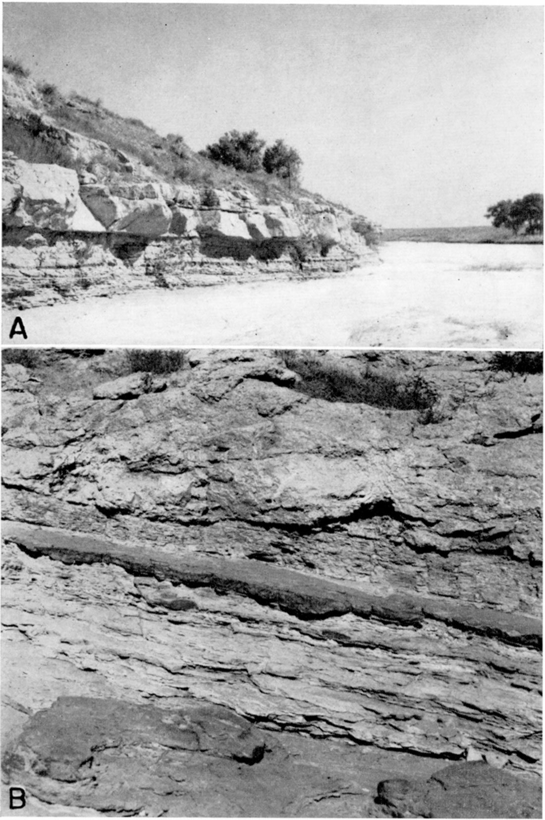
The Cockrum sandstone is composed of fine- to medium-grained, light-tan, buff, brown, or reddish-brown sandstone that is commonly ferruginous, and light-colored shale or clay. Sandstone is predominant and at the outcrops constitutes 40 to 70 percent of the formation. In general the sandstones are composed of fine, subangular to angular quartz grains. Iron oxide is the principal cementing agent and imparts to the sandstone the brown or reddish brown color. In some places the sandstones are hard and tightly cemented and at other places they are soft and loosely cemented. Some of the sandstone has been cemented with a calcareous cement, and in Morton county some of the sandstone is reported to have been recemented with silica to form steel-gray dense quartzite (MeLaughlin, in press). In some outcrops the sandstone layers are thin bedded and alternate with layers of shale or clay; in other outcrops they are massively bedded (pl. 8A). The individual beds range in thickness from less than 1 foot to 10 feet. The alternate beds consist of sandy clay, clay-shale, or shale that is generally gray or yellow, but in some places is reddish or purplish.
Plate 8—A, Ledge of Cockrum sandstone along Bear creek in the SE sec. 21, T. 29 S., R. 43 W. B, Outcrop of shale in the Cockrum sandstone on north side of Bear creek in the SW sec. 15, T. 29 S., R. 43 W., capped by cemented sands and gravels of the Ogallala formation. Note the thin, dark layer of ironstone several inches below the contact. Beds do not dip as steeply as shown.
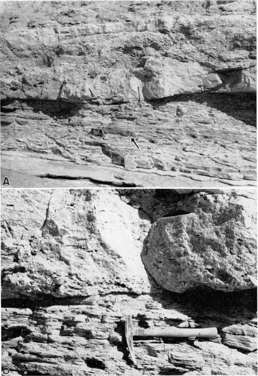
Probably the most striking feature of this formation, at least at the outcrops, is the abundance of ferruginous material. Much of the sandstone is cemented by iron oxide and may also contain numerous small ironstone concretions. A thin layer of "ironstone" (term used by Darton, 1920, p. 4) 1 to 6 inches thick is exposed at several places along Bear creek southwest of Johnson, one of which is shown in plate 8B. This "ironstone" contains very little sand, has a dark-red color, is extremely hard, and generally forms small ledges on the outcrops. Large disk-shaped iron concretions were found embedded in the yellow and gray shale directly below the Ogallala-Cockrum contact at the exposure in the SW sec. 15, T. 29 S., R. 43 W. (pl. 9A). These disk-shaped concretions are dark red and are as much as 3 feet in diameter.
Plate 9—Base of the Ogallala formation resting unconformably on eroded shale in the Cockrum sandstone in the SW sec. 15, T. 29 S., R. 43 W. A. The sharp contact between the Cockrum and Ogallala may be seen just above the head of the pick. The arrow points to one of the numerous iron concretions in the shale of the Cockrum. B. Close-up view of the contact, showing the conglomeratic nature of the material at the base of the Ogallala. (Photographs by S. W. Lohman.)
The following measured sections indicate the lithology of the Cockrum sandstone at the outcrops:
| Section along Bear creek in the SW sec. 15, T. 29 S., R. 48 W. | Thickness, in feet |
|
|---|---|---|
| Ogallala formation: | ||
| 4. Conglomerate, tightly cemented, hard, containing small to large fragments of the material from the Cockrum sandstone. | ||
| (Unconformity.) | ||
| Cockrum sandstone: | ||
| 3. Shale, soapy, yellow and gray, contains disk-shaped iron concretions as much as 3 feet in diameter | 3.0 | |
| 2. "Ironstone," hard, dark red | 0.5 | |
| 1. Shale, soapy, yellow and gray, contains iron concretions similar to those in bed 3 | 5.0 | |
| Total thickness of Cockrum exposed | 8.5 | |
| Section of Cockrum sandstone along Bear creek in the NW sec. 14, T. 29 S., R. 43 W. (Darton, 1920, p. 4.) | Thickness, in feet |
|---|---|
| 5. Sandstone, soft | 3.0 |
| 4. Sandstone, hard, massive, brown to buff | 4.0 |
| 3. Clay, light gray, sandy, containing thin beds of brown sandstone | 6.0 |
| 2. Sandstone, hard, massive | 4.6 |
| 1. Clay, gray, shaly, containing 6-inch ironstone layer near base | 12.0 |
| Total thickness exposed | 29.6 |
| Section of Cockrum sandstone along Bear creek in the NW sec. 14, T. 29 S., R. 48 W. (Darton, 1920, p. 5.) | Thickness, in feet |
|---|---|
| 6. Sandstone, thin bedded | 6.0 |
| 5. Sandstone, massive | 10.0 |
| 4. Shale, dark | 3.0 |
| 3. Clay, thin sandstone, and ironstone | 8.0 |
| 2. Sandstone and shale, thin bedded | 4.0 |
| 1. Sandstone, gray, in part massive | 8.0 |
| Total thickness exposed | 39.0 |
In southern Hamilton county the Cockrum sandstone is overlain by a gray-black, fissile clay shale (Graneros). The topmost beds of the Cockrum sandstone grade into the overlying shale so that there is no sharp contact between the two. According to Bass (1926, p. 73) lenses of sandstone interfinger with the shale in the basal part of the Graneros.
The Cockrum sandstone is underlain conformably by the blueblack to gray-black Kiowa shale.
Distribution and thickness
The Cockrum sandstone crops out along Bear creek and Sand arroyo in southwestern Stanton county, as shown in plate 1, along a tributary of North Fork of Cimarron river in northern Morton county, and in draws and along the lower slopes on the southern side of the ridge in southern Hamilton county, and it was encountered in all the test holes drilled in Stanton county. It may therefore be assumed that the Cockrum sandstone is present either at the surface or below the surface nearly everywhere in the county. During the period of erosion that preceded the deposition of Tertiary sediments great quantities of Cretaceous sediments were eroded away, and this may account for the probable absence of the Cockrum in the bottom of the trough in northern Stanton county (cross section AA', plate 4). Test hole 5 at Johnson encountered only 20.5 feet of the Cockrum sandstone before penetrating the Kiowa shale, which is good evidence that the Cockrum might be entirely lacking in the deeper part of the trough 1 or 2 miles north of Johnson.
The base of the Cockrum sandstone is not exposed at any of the outcrops in the county, so the maximum thickness of the formation was estimated from the logs of test holes and wells, and was found to exceed 100 feet. In some places, however, the Cockrum is less than 100 feet thick and at other places it is absent entirely, as indicated above.
Age and correlation
The Cockrum sandstone is Late Cretaceous in age and is equivalent to the Dakota sandstone of southeastern Colorado. Darton (1906, p. 25) and other early workers in eastern Colorado used the terms Dakota sandstone or Dakota formation to include all the rocks above the Morrison formation and below the Graneros shale, but these rocks are now included in the Purgatoire formation and Dakota sandstone. Darton at that time recognized that rocks of different ages were being included under the one name, and in 1920 he restricted the name Dakota sandstone in western Kansas to include only the rocks above the Kiowa shale and below the Graneros shale (Darton, 1920). Because Dakota is here used as a group name for the Cretaceous rocks below the Graneros shale, the name Cockrum is used to designate those rocks that were formerly called the Dakota sandstone.
Water supply
The Cockrum sandstone is the most widely used water-bearing formation below the Ogallala formation in Stanton county. The Ogallala formation in the western and southwestern parts of the county is in places nearly barren of water so that in such places it is necessary to drill through the Ogallala formation into the Cockrum sandstone in order to obtain a sufficient supply of water for domestic or stock use.
The Cockrum sandstone is reported by well drillers to be of finer texture than the deeper Cheyenne sandstone, but in most places the Cockrum is sufficiently permeable to yield adequate quantities of water to wells. In a few places where the Cockrum is thin or tightly cemented it is necessary to drill to the underlying Cheyenne sandstone to obtain an adequate supply of water. Only seven of the recorded wells in Stanton county have been drilled through the Cockrum sandstone to the deeper lying Cheyenne sandstone, however. The Dakota (Cockrum) sandstone yields water to flowing artesian wells in the vicinity of Blaine in southeastern Colorado. In Stanton county the water in the Cockrum generally is under some artesian head, but the head is not sufficient to produce flowing wells.
Almost a fourth of the recorded wells in Stanton county obtain water from the Cockrum sandstone. Most of these are domestic or stock wells, but one well (100) supplies water to the city of Manter. The wells are 62 to 278 feet deep and the depth to water level ranges from 53 to 242.5 feet below the surface. All the wells that obtain water from the Cockrum sandstone are located in the western or southwestern part of the county.
Eight analyses indicate that water from the Cockrum sandstone is moderately hard calcium bicarbonate water, and contains a moderate amount of sulphate and only a small amount of chloride. It is similar in quality to water from the Ogallala formation. Representative analyses are shown in figure 6.
Tertiary and Quaternary Systems
Pliocene (including the Ogallala formation) and Pleistocene undifferentiated
The material below the loess, dune sand, and alluvium and above the Cretaceous bedrock in Stanton county probably represents deposits of more than one age. This material is here referred to the Pliocene (including the Ogallala formation) and Pleistocene undifferentiated. A discussion of the age is given below.
For simplicity, because it has not been possible to distinguish the Pleistocene from the Pliocene in this area, and owing to the probability that Pleistocene deposits do not occur everywhere in Stanton county, the Pliocene and Pleistocene undifferentiated are included throughout this report under the name Ogallala formation.
Character
The Ogallala formation consists chiefly of calcareous sands, gravels, and silts, the proportions of which may differ greatly from place to place. The materials making up the formation generally are poorly sorted, and gradations from one lithologic type to another may take place within short distances, both laterally and vertically. The sands, gravels, or silts form lenses that overlap one another irregularly (pl. 4). The materials are generally but not altogether unconsolidated. Some of the beds of sand and gravel have been loosely cemented with calcium carbonate and resemble old mortar (pl. 9B). At an exposure in sec. 15, T. 29 S., R. 43 W., the base of the Ogallala consists of gray, hard and compact conglomerate (pl. 9B). The conglomerate is composed of small to large fragments or blocks of sandstone, iron concretions, clay, shale, and lesser amounts of several kinds of igneous rocks—all tightly cemented with calcium carbonate. Most of the material seems to have been derived from Cretaceous formations. Some of the blocks derived from the Cockrum sandstone exceed 12 inches in their greatest dimension. Loosely consolidated beds of sand, gravel, and silt overlie the conglomerate.
The finer materials of the Ogallala formation are composed mostly of silt and include only very small amounts of clay. No beds of clay were found at the outcrops or in the test holes. Lenses of sandy silt ranging in thickness from a few inches to more than 50 feet are common and are likely to be encountered in any part of the formation. The color of the silt is tan, brown, yellow, yellow-brown, or reddish-tan, or shades of gray. Many of the lenses are very calcareous and are white to gray. Test hole 4 in the northeastern part of the county encountered light-gray to white soft clay and volcanic ash at a depth of 80 to 94 feet.
The sands in the Ogallala range in texture from very fine to coarse grained and generally contain scattered pebbles. Well-rounded to subangular quartz grains are dominant in the sands, but there are a few grains of feldspar and of dark minerals. Some of the sand is brown or red-brown, but most of it is tan.
The coarser materials are composed of fine to very coarse gravel. Gravels may be found in almost any part of the formation, but in general they are most abundant and coarsest in the lower part. Smith (1940, pp. 42, 43) has described two distinct facies of gravels and conglomerates on the Ogallala formation based upori the lithology of the pebbles. According to Smith, the one facies occurs only at the base of the formation and is composed chiefly of sandstone, ironstone, and quartzite pebbles that were derived from Cretaceous formations. The other facies occurs above the base of the formation and is composed chiefly of granite, feldspar, felsite, quartzite, and quartz pebbles derived from crystalline igenous and metamorphic rocks. These two facies were recognized in outcrops and in a few of the test holes in Stanton county. The conglomerate at the base of the formation in sec. 15, T. 29 S., R. 43 W., was used by Smith to illustrate the "sandstone, ironstone, and quartzite" facies.
The pebbles making up the gravels are well rounded to angular, and are white, gray, brown, yellow, red, or red brown. The gravels are rarely clean, but generally have considerable sand or silt mixed with them.
Caliche in the form of nodular calcium carbonate may be found mixed with the silt, sand, or gravel throughout the Ogallala formation. These nodules are white to gray and as a rule are fairly soft. A bed of hard caliche 5 feet thick was encountered in test hole 4 at a depth of 311 to 316 feet. A hard, crystalline, grayish-white limestone marked with pinkish irregularly concentric bands crops out near the middle of T. 30 S., R. 43 W. It is only a few inches thick and is broken into irregular blocks of different sizes. This limestone probably represents the cap rock of the Ogallala formation, and may be equivalent to the "algal limestone" of other areas.
Distribution and thickness
The Ogallala formation is present everywhere in Stanton county except in the southwestern part where Bear creek and Sand arroyo have cut through it into the underlying Cockrum sandstone (pl. 1). In about half the county it is covered by a thin mantle of loess, and south of Bear creek in the central part of the county it is covered by dune sand.
The thickness of the formation in Stanton county ranges from less than 50 feet to more than 400 feet. The great range in thickness is due chiefly to the uneven surface on which these sediments were deposited.
The Ogallala attains its greatest thickness in the buried trough in the northern part of the county (plate 4, section AA'). Test hole 5 at Johnson, which is near the deepest part of the trough, penetrated 417 feet of the Ogallala formation before reaching the Cockrum sandstone. The bedrock floor rises toward the north so that the thickness of the Ogallala is only 226 feet at the Hamilton-Stanton county line (test hole 1). About Ills miles north of the county line the Ogallala is only a few feet thick and the Cockrum sandstone is exposed at the surface, owing to post-Ogallala faulting and erosion. From Johnson southward and southwestward the bedrock floor again rises, and in the southwestern part of the county it is exposed in the stream valleys. At Manter, the thickness of the Ogallala is about 200 feet and just east of Saunders it is less than 50 feet. Six miles south of Johnson the thickness is 216 feet (test hole 8) and at the Stanton-Morton county line south of Johnson, the thickness is only 81 feet (test hole 11). East of this point the Ogallala thickens. At a point about 6 miles east of State highway 27 on the StantonMorton county line, 191 feet of the Ogallala was penetrated in test hole 10 and, at a point about 5 miles farther east, 261 feet was penetrated in test hole 9. In northwestern Stanton county 297 feet of the Ogallala was drilled in test hole 6, and 182 feet in test hole 3, indicating that the formation thins toward the northwest. In the eastern part of the county the Ogallala probably attains its maximum thickness near Big Bow. The thickness of the formation was 329 feet in test hole 4, about 5 miles north of Big Bow, and 383 feet in test hole 7, which is 6 miles south of Big Bow. The thickness of the Ogallala is probably greater in the lowest part of the trough, which is somewhere between these two test holes.
Origin
The materials of the Ogallala formation were deposited by widely shifting streams that originated in the Rocky Mountains (Johnson, 1900, p. 638). This manner of deposition explains the lenticular character of the materials and the many other irregular features of the formation. The sands and gravels probably represent channel deposits and the silts probably represent flood plain deposits. Johnson (1900, p. 638) briefly summarizes the origin of the High Plains as follows:
The original smooth plain … was alluvial, i.e., stream-built. It was spread, in substantially its present position as to elevation and inclination, by widely shifting, heavily loaded, and depositing streams from the mountains. Shifting deposition, burial, and plain building constitute the normal habit of desert: streams. … Virtually the same mountain streams are at present cutting away and degrading where formerly they made broad fan-form deposits and built up.
Smith (1940, p. 79) believes that the silts and clays in the Ogallala were derived from soils and weathering products in the mountain area, and that the abundant limy material was derived from weathering of Paleozoic limestones and of calcic minerals in the crystalline rocks of the mountain area, but that some of the limy material may have been provided by weathering in situ after deposition. According to Theis, Burleigh, and Waite (1935, p. 1) the coarse sediments in the Ogallala "were laid down by streams, but the structureless material appears to have been deposited by the wind."
Age and correlation
Although very little evidence is available, it seems certain that the material described: above represents deposits of both Pliocene and Pleistocene age. Heretofore these deposits have been described as belonging to the Ogallala formation (Pliocene), which is so widespread in the western part of the state (Darton, 1920, p. 6). It now seems, however, that a part is of Pleistocene age.
A fossil gastropod taken from test hole 4 (fig. 4) at a depth of 100 to 109 feet was identified by Calvin Goodrich (written communication) as Succinea avara Say. According to Hibbard (personal communication) this form is commonly found in undoubted Pleistocene deposits of Meade county, Kansas. Other evidence suggesting a Pleistocene age for some of the surficial deposits in Stanton county is the occurrence, in sec. 13, T. 26 S., R. 41 W., Hamilton county, only about 3.5 miles north of the Hamilton-Stanton county line, of volcanic ash, which is described by both Landes (1928, p. 25) and Bass (1926, p. 60) as probably belonging to the Pleistocene. The ash is underlain by 2 feet of soil that rests directly on the Cockrum sandstone. This ash may be correlative with ash in Meade county that contains undoubted Pleistocene fossils (Hibbard, personal communication).
Water supply
The sands and gravels of the Ogallala formation are by far the most productive source of ground water in Stanton county. [Note: The saturated part of the Pliocene and Pleistocene undifferentiated probably is entirely within the Ogallala.] About 70 percent of the domestic and stock wells, one of the two municipal wells, and all the irrigation wells draw water from this formation.
The finer materials of the formation are generally porous and hold considerable water but are not permeable enough to yield water freely, but the coarser materials, the gravels in particular, are very good water bearers and generally yield abundant supplies of water. Beds of water-bearing sand and gravel may be found at almost any depth in the formation, but as a rule are thicker and more permeable in the lower part. Beds of sand and gravel ranging in thickness from a few feet to about 50 feet were drilled in the test holes. The Ogallala is especially thick and permeable in the buried trough. The four irrigation wells are located over this trough and yield 450 to 800 gallons a minute. The city well at Johnson (63) is reported to yield 110 gallons a minute with a total lift of more than 165 feet.
The Ogallala formation is a large underground reservoir that is only partly filled with water. The upper part is dry because the recharge of the reservoir is not sufficient to fill it. In the southwestern and extreme western parts of the county the Ogallala is relatively thin and lies entirely above the water table, and, therefore, will not yield water to wells. The thickness of saturated material in the Ogallala increases toward the east, being greatest near the county line. The thickness of saturated material in the Ogallala is shown by cross sections AA' and BB' on plate 4. Logs of the test holes indicate that more than half of the saturated zone in the Ogallala is composed of sand and gravel, so the amount of water available is large.
Twenty-four analyses indicate that the waters in the Ogallala are moderately hard, calcium carbonate waters. With few exceptions the samples contain 170 to 300 parts per million of hardness and 150 to 250 parts per million of bicarbonate. The chloride content is uniformly low (less than 25 parts per million). The sulphate, fluoride, and iron content are very variable. Representative analyses are shown graphically in figure 6.
Quaternary System
Loess
Much of the upland area in Stanton county is covered by a thin mantle of buff to brown loess. The areas mapped as loess on plate 1 correspond to the areas mapped as "soil group 1" by the Soil Conservation Service (Joel, 1937, map 5). The soils of this group were found by McLaughlin (oral communication) to represent loess or loessial materials, and are described by Joel (1937, p. 11) as consisting of—
Silt loams, clay loams, and silty clay loams with also some clays, and are underlain by heavy clay subsoils somewhat lighter in color than the topsoils.
The loess is composed chiefly of silt, but contains minor amounts of clay and very fine sand. Analyses in table 4 give the mechanical composition of samples of loess collected in Stanton county by Smith (1940, p. 122).
Table 4—Mechanical analyses of loess from Stanton county, Kansas (Analyzed by H. T. U. Smith)
| Location | Depth of sample (feet) |
Mechanical composition (percentage by weight) |
|||||
|---|---|---|---|---|---|---|---|
| More than 0.5 mm |
0.5-0.25 mm | 0.25-0.125 mm | 0.125-0.062 mm | 0.062-0.031 mm | Less than 0.031 mm |
||
| NW sec. 12, T. 27 S., R. 41 W. |
3 | 0 | 0.3 | 4.0 | 37.7 | 36.0 | 22.0 |
| SW sec. 30, T. 28 S., R. 42 W. |
4 | 0.03 | 0.4 | 3.5 | 21.1 | 58.5 | 16.6 |
| NE sec. 24, T. 29 S., R. 41 W. |
3 | 0 | 0.3 | 4.5 | 30.8 | 48.0 | 16.0 |
The loess occurs only on the uplands in the interstream areas. Its thickness is not known definitely but is thought to range from a foot or less to about 10 feet. The loess was found to be 8 feet thick in a pit dug at Johnson.
The loess is relatively impermeable and lies above the zone of saturation and therefore does not yield any water to wells. The upper part of the loess absorbs much of the rainfall and returns it to the atmosphere by evaporation or through the growing vegetation, and not much of the rainfall percolates through the loess soil to the ground-water reservoir. A large part of the precipitation that falls on its surface in heavy storms is lost by surface run-off.
Dune Sand
Dune sand covers the Ogallala formation in a belt about 19 miles long and less than 1 mile to about 2.5 miles wide south of Bear creek. It is composed chiefly of fine- to medium-grained quartz sand and contains smaller amounts of silt, clay, and coarse sand. The sand has been accumulated by the wind to form small, moderately steep hills, some of which are 40 to 50 feet high, and low mounds.
No wells obtain water from the dune sand in Stanton county for it is everywhere above the water table, but owing to the fact that the sand is loose and highly permeable, it probably serves as an important catchment area for ground-water recharge from local rainfall.
Alluvium
Alluvium has been deposited in most of the stream valleys, and consists of sand, gravel, silt, and clay derived mainly from the Ogallala formation but in part from the Cretaceous formations into which the streams have cut. Its thickness is not known but in general it is thought to be relatively slight and in some stream channels there is no alluvium. Most of the alluvium occupies the bottoms of the present channels, and lies directly upon the Ogallala formation except in the southwest part of the county in the channels of Bear creek and Sand arroyo where the alluvium overlies Cretaceous shale (Cockrum).
Two of the recorded wells in the county end in alluvium (109 and 113). Both wells are shallow and have been abandoned. Most of the alluvium lies above the water table and hence does not supply water to wells. Where the alluvium lies on impervious material it might possibly contain small bodies of perched ground water that are not connected with the main body of ground water. The amount of water held in such small reservoirs probably would not be sufficient to supply wells, however, and probably would be depleted rapidly under conditions of drought.
Prev Page--Utilization, Quality || Next Page--Bibliography
Kansas Geological Survey, Geology
Placed on web Oct. 5, 2018; originally published November 1941.
Comments to webadmin@kgs.ku.edu
The URL for this page is http://www.kgs.ku.edu/Publications/Bulletins/37/06_form.html