![]()
Prev Page--Ground water || Next Page--Formations
Ground Water, continued
Utilization of Water
All the water used in Stanton county is supplied by drilled wells. Records of 143 wells in the county and 4 outside the county were obtained and are [in the Table of Well Records]. Of the 143 wells in the county for which records are given, 136 are used for domestic and stock purposes, 4 are used for irrigation, 2 are used for public supplies, and 1 is used by a railroad.
Domestic and Stock Supplies
Domestic and stock water supplies in Stanton county are obtained from wells that range in depth from less than 50 feet to 256 feet and are 4, 5, 5 1/2, or 6 inches in diameter. Most of them are 5 1/2 or 6 inches in diameter.
The wells used for domestic or stock supplies generally are equipped with cylinder pumps operated by windmills. The most common type of cylinder pump consists of a vertical pipe 1 1/2 to 3 inches in diameter equipped with a cylinder at the lower end, either above or below the surface of the water. The water is discharged through a short horizontal pipe connected by a T to the top of the vertical pipe. Six of the domestic and stock wells were equipped with hand-operated cylinder pumps and three were equipped with pumps that could be operated either by a windmill or by hand.
At the time of this investigation 69 of the 136 domestic and stock wells were no longer in use. Only the casing was left in 21 of these wells, the pump and pipe having been removed.
In Stanton county the ground water is hard, but generally is of satisfactory chemical character for domestic uses not affected by hardness and for use by stock.
Public Water Supplies
Only two communities in Stanton county have public water supplies—Johnson City and Manter, both of which are supplied from wells.
Johnson City is supplied from one drilled well (63),223 feet deep, owned by the city. The well is cased with 10-inch steel casing, the lower 30 feet of which is perforated, and it is gravel-packed. It is equipped with a turbine pump operated by an electric motor rated at 20 horsepower, and is reported to yield no gallons a minute. The measured static water level was 163 feet below the land surface in August, 1939. No data are available on the draw-down. The water is pumped directly into the mains by the turbine in the well and the excess flows into an elevated steel tank, which has a capacity of 50,000 gallons. According to Elam Hilty, city water superintendent, the average daily consumption is 9,570 gallons, and the maximum daily consumption on record was 53,500 gallons used in July, 1939. Although the water is hard (analysis 63) it is in other respects satisfactory for all ordinary uses and is not treated.
Manter is supplied with water from a drilled well (100) owned by the city. The well is 278 feet deep and penetrates the Cockrum sandstone (for log see [later]). It is cased with 12-inch perforated steel casing and is equipped with a turbine pump operated by an electric motor rated at 30 horsepower. The yield of the well is reported to be 100 gallons a minute. The static level of the water is reported to be 240 feet below the surface, but the draw-down is not known. The water is pumped directly into the mains by the turbine and the excess flows into an elevated steel tank, which has a capacity of 15,000 gallons. The chemical character of the water is indicated by analysis 100. The water is not treated.
Railroad Supplies
The Atchison, Topeka and Santa Fe railway has a drilled well (101) at Manter that supplies water for locomotive boilers. The well is 475 feet deep and is cased with 12 1/2-inch steel casing to a depth of 87.5 feet; the rest of the hole is cased with 8-inch steel casing that is perforated from a depth of 195.4 feet to the bottom. The well is equipped with a lift pump operated by an electric motor. The static water level is reported to stand 211 feet below the surface. No data are available regarding the yield or draw-down. The well is interesting because it is drilled through the bedrock formations into the top of Triassic (?) redbeds. A reported log of the well is given [later].
Irrigation Supplies
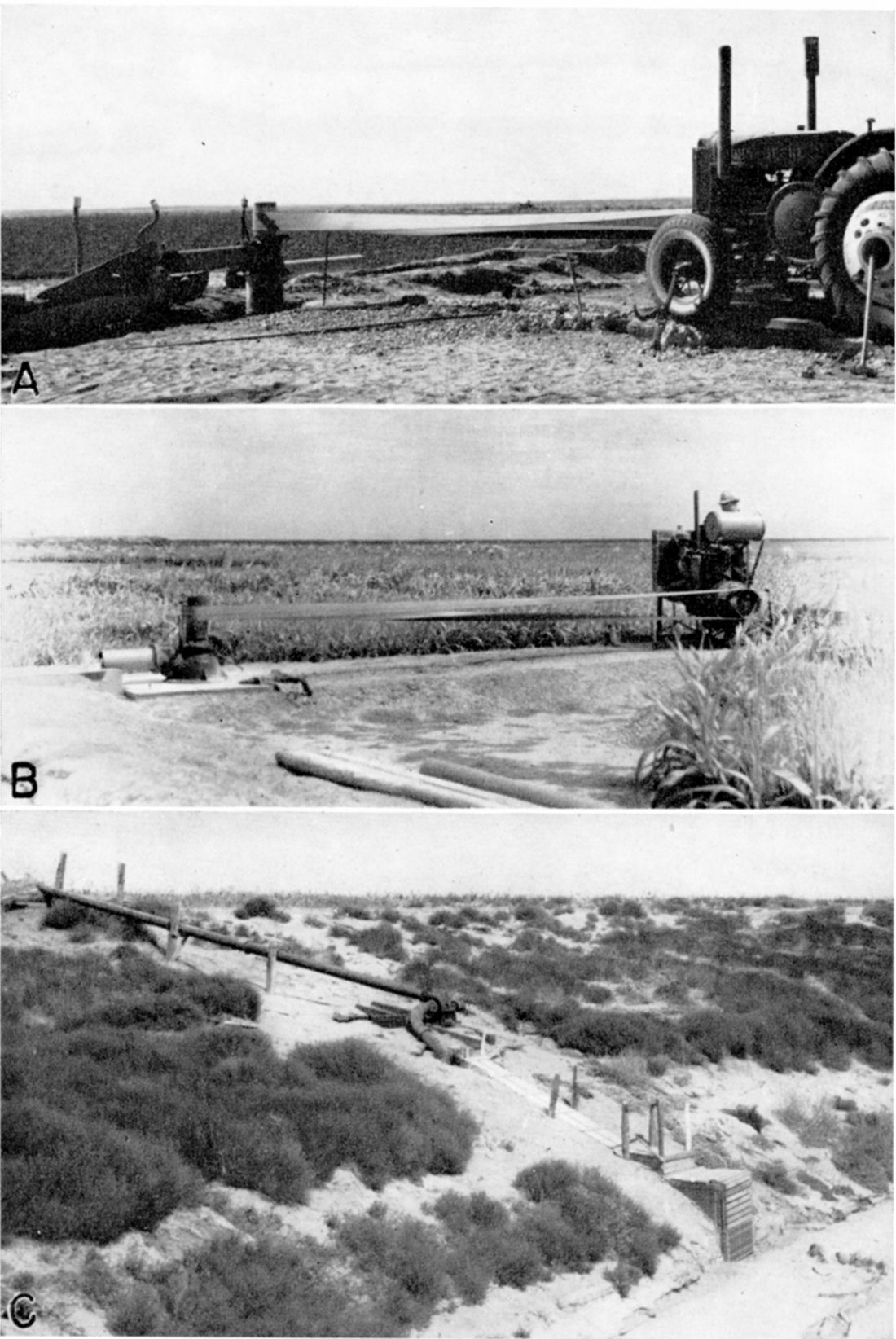
Interest in irrigation has increased among Stanton county farmers during the last several years as a result of nearly a decade of drought. A few attempts have been made to use surface water for irrigating small tracts of land along the streams. Fred Collingwood irrigates a part of the SW sec. 22, T. 27 S., R. 40 W. by pumping water from Bear creek (pl. 7C). He operates his pump 3 or 4 times a year during high-water stages. Charles Winger has a similar plant for pumping water from Bear creek in the SE sec. 22, T. 27 S., R. 40 W. There are no perennial streams in the county, hence surface water is available only after heavy rains have fallen and none is available during dry periods when it is most needed.
Plate 7—A, Irrigation well (19) in the NW corner NE sec. 35. T. 27 S., R. 40 W., owned by Clarence Winger; B, Irrigation well (6) in the SE sec. 27, T. 27 S., R. 39 W., owned by M. P. Molz; C. Surface-water pumping plant in the SW sec. 22, T. 27 S., R. 40 W., owned by Fred Collingwood.
The use of ground water for irrigation has been barely started. At the present time there are four drilled irrigation wells in the county, descriptions of which are given in the well tables and in more detail in the following paragraphs.
Brown well
The irrigation well (78) of H. H. Brown (R. P. Dotzour, lessee) is on the upland plain 1 mile south of Big Bow in the SE corner SW, sec. 2, T. 29 S., R. 39 W. It is 330 feet deep and is cased with 60-inch steel casing from the surface to a depth of about SO feet, and with 18-inch steel casing from there to the bottom. The casing was perforated with a cutting torch and covered with a copper screen such as that used for doors and windows. The well is not gravel-packed. The static water level in the well stands about 56 feet below the surface. Brown, in a personal communication, reports:
The formation is a fine to medium-sized sand and gravel with some 27 different water strata to the bottom of the well with alternate layers of clay.
The well is equipped with a turbine pump, which has a capacity of 2,000 gallons a minute. Originally the pump was operated by a 75-horsepower Diesel engine, but it is now driven by a tractor. The reported yield of the well, when a tractor is used for power, is 650 gallons a minute with a draw-down of 13 feet.
The well was drilled in 1930 and was used for 3 years by Brown to irrigate 100 acres of sugar beets and potatoes. From 1933 to 1936 the well was not used. In 1937 Dotzour pumped water from it to irrigate about 20 acres of wheat, after which the well again was idle until the fall of 1939, when Dotzour used the well to irrigate wheat. He reports that there was plenty of water available for irrigation between 1937 and 1939, but that the ground was not in suitable condition during this period, owing to blowing dust.
Mole well
The irrigation well of M. P. Molz (6) is in the shallow-water area south of Bear creek, in the SE corner NE sec. 27, T. 27 S., R. 39 W. (pl. 7B). It is reported to be 83 feet deep, and is cased with 18-inch steel casing, the lower 32 feet of which is perforated. Water enters the well from sand and gravel at a depth of 56 to 76 feet. The reported water level is 56 feet below the land surface. The well is equipped with a turbine pump operated by a stationary 20-horsepower combine engine, and is reported to yield 450 gallons a minute with a draw-down of 25 feet. Molz believes that the yield could be increased and the draw-down decreased by drilling the well deeper. The well was drilled in 1936 by the owner. In 1939, wheat and feed crops on 52 acres of land were irrigated with water from the well.
Clarence Winger well
The irrigation well (19) of Clarence Winger, in the NW corner NE sec. 35, T. 27 S., R. 40 W., was drilled in the fall of 1939 by Buell Scott, who used a rotary drill (pl. 7 A). The depth of the well is 182 feet. The lowest 120 feet of the 16-inch galvanized-iron casing is perforated. It is a gravel-packed well and obtains water from sand and gravel (see log of test hole [later]. The water level in the well is reported to be 63 feet below the surface. The well is equipped with a turbine pump operated by a tractor, and yields about 800 gallons a minute with a draw-down of 27 feet after pumping for 6 hours.
Charles Winger well
The irrigation well of Charles Winger, (41), in the NW corner NW sec. 5, T. 2S S., R. 39 W., was drilled by Buell Scott in the fall of 1939, soon after the completion of Clarence Winger's well. It is 160 feet deep, is gravel-packed, and is cased with 18-inch galvanized-iron casing, the lowest 100 feet of which is perforated. The water comes from sand, and the water level in the well is reported to stand 52 feet below the land surface. A pump had not yet been installed when I visited the well in October, 1939, but the owner planned to install a turbine pump and some type of stationary engine. A log of the well is given on [later].
Possibilities of Developing Additional Irrigation Supplies
The amount of water that can be pumped from an underground reservoir without causing excessive permanent lowering of the water table depends on the capacity of the reservoir and on the amount of annual recharge. The quantity of water in storage in the Ogallala formation in Stanton county seems to be large, but the amount of annual recharge to this underground reservoir is relatively small ([earlier]). The largest quantity of water could be pumped without excessive lowering of the water level if the irrigation wells were distributed evenly over Stanton county. Conditions seem to be favorable for irrigation in only a small part of the county, however; in other parts the depth to water is likely to be too great or the surface too irregular for the development of irrigation.
The most favorable area for the use of water from wells for irrigation in Stanton county is the northeastern shallow-water area (p. 33), which is roughly that area northeast of a line drawn from the point where state highway 27 intersects the Stanton-Hamilton county line to the point where Sand arroyo leaves Stanton county. The four existing irrigation wells are located in this area. The water table is everywhere less than 100 feet below the surface, and south of Bear creek, in the eastern part of the area, the water table is less than 50 feet below the surface. The land surface in most places is relatively flat and in that respect is suitable for irrigation.
The water-bearing formation in this area, the Ogallala, ranges in thickness from more than 200 feet to about 350 feet. The water-bearing materials in the Ogallala range in texture from fine sand to coarse gravel, but the character and thickness of these materials vary greatly from place to place even within a short distance, so that some wells encounter more and better water-bearing materials than other wells. If the drilling of an irrigation well is contemplated it is wise to drill several test holes of small diameter first, in order to determine whether or not saturated materials of the proper character and thickness are available. The information gained from the test holes should indicate what type of well should be constructed, whether gravel packing is necessary ([earlier]), and if not, what size screen should be used or what size perforations should be made in the casing.
The thickness of the saturated part of the Ogallala ranges from about 150 feet in the northwestern part of this area to about 300 feet in the eastern part. Coarse water-bearing sands and gravels have been found in most of the wells already drilled in this area, and as a rule the coarser, more permeable materials are found near the base of the Ogallala formation, although this is not everywhere true. Relatively large yields probably can be obtained from properly constructed wells at most places in this area.
In an area south of the area described above and east of the 100-foot depth-to-water lines as shown on plate 2, the conditions are similar, but the water table is in general farther below the surface. The water table is less than 100 feet and more than 60 feet below the surface in this area.
The surface relief in the southwestern shallow-water areas ([earlier]) is in general too great for successful irrigation, and it is doubtful whether the Cockrum or Cheyenne sandstones would yield sufficient water.
Ground water has been used for irrigation at other places on the uplands in the High Plains where the water level lies as deep as it does in the northeastern part of Stanton county. On the upland plains in the vicinity of Garden City sugar beets are grown by means of irrigation with water from wells. In that area the wells obtain water from the Ogallala formation and are generally between 200 and 300 feet deep, and the water level generally stands about 40 or 45 feet below the surface, but is as much as 70 feet in a few wells.
Based on records of the Division of Water Resources of the Kansas State Board of Agriculture, approximately 12,000 acres of land was irrigated with water pumped from wells in the so-called Scott county shallow-water area in 1939. H. A. Waite, in a personal communication, reports that the depth to water level in this area ranges from about 20 to 90 feet. An irrigation well on the uplands northeast of Ensign in southeastern Gray county is reported by Lohman (1938a, p. 4) to be 200 feet deep and the water level, as measured in November, 1937, 165.5 feet below the land surface. According to W. N. White (written communication, January 15, 1941), an area of about 230,000 acres was irrigated with water from about 1,700 wells on the High Plains of Texas near Plainview, Lubbock, Muleshoe, Hereford, and Texline in 1939. He reports that the wells are 100 to 300 feet deep and the water level in the irrigated areas ranges from about 20 feet to 100 feet or more below the surface. Most of the wells are equipped with turbine pumps operated by automobile engines, and yield 300 to 2,000 gallons a minute, the average being about 700 gallons a minute.
Quality of Water
The chemical character of the well waters in Stanton county is shown by the analyses of water from 38 representative wells given in table 3. The samples of water were collected by me and analyzed by Robert H. Hess, chemist, in the water and sewage laboratory of the Kansas State Board of Health. The analyses show only the dissolved mineral content of the waters and do not in general indicate the sanitary condition of the waters.
The fluoride content of the waters was determined by the Modified Sanchis method, and the other constituents given were determined by the methods used by the U. S. Geological Survey.
Table 3—Analyses of water from wells in Stanton county, Kansas. (Analyzed by Robert H. Hess. Quantities are expressed in parts per million. Equivalents per million are shown in italics. One part per million is equivalent to 1 pound of substance per million pounds of water and is equal to 8.33 pounds per million gallons.)
| Well No. Plate 2 |
Location, depth, geologic horizon | Date of collection, 1939 |
Temp. (°F) |
Iron (Fe) |
Calcium (Ca) |
Magnesium (Mg) |
Sodium and potassium (Na + K)† |
Bicarbonate (HCO3) |
Sulphate (SO4) |
Chloride (Cl) |
Fluoride (F) |
Nitrate (NO3) |
Total dissolved solids† |
Hardness (calculated as CaCO3) |
||
|---|---|---|---|---|---|---|---|---|---|---|---|---|---|---|---|---|
| Total | Carbonate | Noncarbonate | ||||||||||||||
| T. 27 S., R. 39 W. | ||||||||||||||||
| 2 | NW corner sec. 2, 96 feet, Ogallala | Oct. 21 | 60 | 0.08 | 44 2.20 |
17 1.40 |
23 .99 |
232 3.80 |
12 .25 |
7.0 .20 |
1.6 .08 |
16 .26 |
237 | 180 | ‡180 | 0 |
| 7 | NE corner SE sec. 29, 80 feet, Ogallala | Oct. 21 | 59 | .76 | 66 3.39 |
30 2.47 |
33 1.43 |
177 2.90 |
177 3.68 |
16 .45 |
1.4 .07 |
12 .19 |
427 | 295 | 145 | 150 |
| T. 27 S., R. 40 W. | ||||||||||||||||
| 8 | NE corner SE SW sec. 1, 150 feet, Ogallala | Oct. 21 | 59 | .04 | 54 2.69 |
13 1.07 |
16 .68 |
215 3.53 |
26 .54 |
6.0 .17 |
1.1 .06 |
8.8 .14 |
232 | 188 | 176 | 12 |
| 12 | NW SW sec. 17, 71 feet, Ogallala | Oct. 21 | 59 | 1.50 | 71 3.54 |
22 1.81 |
33 1.42 |
185 3.03 |
156 3.24 |
11 .31 |
1.0 .05 |
8.8 .14 |
397 | 270 | 152 | 118 |
| 19 | NW corner NE sec. 35, 182 feet, Ogallala | Oct. 25 | 60 | .03 | 66 3.29 |
19 1.56 |
24 1.03 |
174 2.85 |
122 2.54 |
9.0 .25 |
.9 .05 |
12 .19 |
340 | 243 | 143 | 100 |
| T. 27 S., R. 41 W. | ||||||||||||||||
| 20 | SW corner SW sec. 3, 117 feet, Ogallala | Oct. 30 | 59 | .10 | 76 3.79 |
23 1.83 |
30 1.32 |
181 2.97 |
167 3.47 |
12 .34 |
1.1 .06 |
10 .16 |
410 | 284 | 148 | 136 |
| 21 | SW corner SE sec. 15, 123.5 feet, Ogallala | Oct. 24 | 60 | .18 | 66 3.29 |
20 1.64 |
28 1.21 |
172 3.82 |
120 2.50 |
18 .51 |
1.0 .05 |
16 .26 |
355 | 247 | 141 | 106 |
| 24 | SE corner SW SW sec. 31, 172 feet, Ogallala | Oct. 24 | 60 | .20 | 52 2.59 |
13 1.07 |
25 1.10 |
172 2.82 |
75 1.56 |
7.0 .20 |
.7 .04 |
8.8 .14 |
268 | 184 | 141 | 43 |
| T. 27 S., R. 42 W. | ||||||||||||||||
| 26 | NE NE sec. 8, 138 feet, Ogallala | Oct. 25 | 60 | .39 | 64 3.19 |
20 1.64 |
29 1.28 |
178 2.92 |
129 2.68 |
12 .34 |
.8 .04 |
8.0 .13 |
352 | 242 | 146 | 96 |
| T. 27 S., R. 43 W. | ||||||||||||||||
| 34 | NE corner SE NE sec. 15, 199 feet, Cockrum | Oct. 20 | 61 | 1.7 | 50 2.50 |
13 1.07 |
24 1.02 |
185 3.03 |
56 1.16 |
7.0 .20 |
.8 .04 |
9.7 .16 |
255 | 182 | 152 | 30 |
| 37 | NE corner NE sec. 33, 120.5 feet, Cockrum (?) | Oct. 20 | 61 | 11 | 49 2.45 |
14 1.15 |
26 1.12 |
161 2.64 |
79 1.64 |
9.0 .25 |
.9 .05 |
8.4 .14 |
278 | 200 | 132 | 68 |
| T. 28 S., R.39 W. | ||||||||||||||||
| 39 | NE corner SE sec. 3, 65.5 feet, Ogallala | Oct. 25 | 59 | 5.0 | 75 3.74 |
39 3.21 |
67 2.90 |
189 3.10 |
278 5.78 |
25 .71 |
2.0 .11 |
9.2 .15 |
595 | 357 | 155 | 202 |
| 42 | SE corner SW sec. 8, 79.5 feet, Ogallala | Oct. 21 | 59 | 1.3 | 73 3.64 |
30 2.47 |
35 1.52 |
256 4.20 |
139 2.89 |
14 .89 |
1.3 .07 |
4.9 .08 |
427 | 308 | 210 | 98 |
| T. 28 S., R. 40 W. | ||||||||||||||||
| 53 | NW corner NW sec. 35, 102 feet, Ogallala | Oct. 25 | 53 | 3.5 | 55 2.74 |
17 1.40 |
27 1.19 |
167 2.74 |
93 1.93 |
16 .45 |
.9 .05 |
10 .16 |
306 | 214 | 137 | 77 |
| 55 | NW corner NW sec. 1, 117 feet, Ogallala | Oct. 24 | 60 | 1.3 | 51 2.54 |
17 1.40 |
23 1.00 |
232 3.80 |
28 .58 |
3.0 .08 |
.9 .05 |
27 .43 |
267 | 200 | 190 | 10 |
| 60 | NE corner SW sec. 23, 193 feet, Ogallala | Oct. 25 | 61 | 1.6 | 46 2.30 |
13 1.07 |
25 1.09 |
183 3.00 |
50 1.04 |
7.0 .20 |
.6 .05 |
12 .19 |
247 | 172 | 150 | 22 |
| 63 | SE NE SW sec. 36, 223 feet, Ogallala | June | 0 | 50 2.50 |
18 1.48 |
26 1.13 |
181 2.97 |
81 1.68 |
10 .28 |
1.0 |
11 .18 |
317 | 199 | 148 | 51 | |
| T. 28 S., R. 42 W. | ||||||||||||||||
| 64 | NW Corner SW sec. 9, 248.5 feet, Ogallala | Oct. 25 | 62 | .87 | 53 2.64 |
13 1.07 |
18 .78 |
148 2.43 |
77 1.60 |
8.5 .24 |
.7 .04 |
11 .18 |
256 | 187 | 121 | 66 |
| 65 | NE corner SW SW sec. 13, 213 feet, Ogallala | Oct. 20 | 59 | 4.2 | 46 2.30 |
19 1.56 |
27 1.17 |
190 3.12 |
72 1.50 |
9.0 .25 |
.9 .05 |
7.1 .11 |
280 | 201 | 156 | 45 |
| 69 | NE corner SE SE sec. 32, 68 feet, Ogallala (?) | Oct. 20 | 59 | .04 | 47 2.35 |
5.8 .48 |
12 .54 |
154 2.53 |
25 .52 |
3.5 .10 |
.5 .03 |
12 .19 |
183 | 142 | 126 | 16 |
| T. 28 S., R. 43 W. | ||||||||||||||||
| 71 | NW corner sec. 12, 173 feet (?) | Oct. 20 | 62 | 2.4 | 51 2.54 |
12 .99 |
23 1.01 |
181 2.97 |
59 1.23 |
7.0 .20 |
.6 .05 |
7.1 .11 |
253 | 181 | 148 | 33 |
| 74 | SW corner SE sec. 27, 213 feet, Cockrum | Oct. 20 | 61 | 13 | 35 1.75 |
19 1.56 |
42 1.81 |
183 3.00 |
74 1.54 |
12 .34 |
2.0 .11 |
8.0 .13 |
297 | 189 | 150 | 39 |
| T. 29 S., R. 39 W. | ||||||||||||||||
| 78 | SE corner SW sec. 2, 330 feet, Ogallala | Oct. 25 | 61 | 0 | 58 2.89 |
21 1.73 |
33 1.43 |
176 2.89 |
123 2.56 |
12 .34 |
1.0 .05 |
13 .21 |
349 | 231 | 144 | 87 |
| 80 | SW corner SE SW sec. 5, 92 feet, Ogallala | Oct. 25 | 59 | .53 | 59 2.94 |
18 1.48 |
30 1.30 |
188 3.08 |
103 2.14 |
9.0 .25 |
.7 .04 |
13 .21 |
327 | 222 | 154 | 68 |
| 85 | NW corner sec. 30, 94 feet, Ogallala | Oct. 25 | 60 | 3.3 | 42 2.10 |
20 1.64 |
35 1.53 |
188 3.08 |
83 1.73 |
8.0 .23 |
1.3 .07 |
9.7 .16 |
296 | 193 | 154 | 39 |
| T. 29 S., R. 41 W. | ||||||||||||||||
| 92 | SE corner sec. 11, 201 feet, Ogallala | Oct. 24 | 61 | .30 | 43 2.15 |
12 .99 |
19 .82 |
173 2.84 |
38 .79 |
3.0 .08 |
1.3 .07 |
11 .18 |
214 | 158 | 142 | 16 |
| 96 | NE SE sec. 35, 209 feet, Ogallala | Oct. 21 | 63 | .68 | 48 2.40 |
20 1.64 |
21 .90 |
198 3.25 |
58 1.21 |
7.5 .21 |
1.6 .08 |
12 .19 |
268 | 203 | 162 | 41 |
| T. 29 S., R. 42 W. | ||||||||||||||||
| 100 | NW SW sec. 14, 278 feet, Cockrum | Oct. | 0 | 66 3.29 |
18 1.48 |
4 .16 |
190 3.12 |
72 1.50 |
9.0 .25 |
1.0 | 3.7 .06 |
335 | 239 | 156 | 83 | |
| 106 | SE NW SW sec. 34, 215 feet, Cockrum | Oct. 21 | 62 | .18 | 49 2.45 |
18 1.48 |
23 1.01 |
204 3.35 |
52 1.08 |
7.0 .20 |
3.0 .16 |
9.2 .15 |
263 | 197 | 167 | 30 |
| T. 29 S., R. 43 W. | ||||||||||||||||
| 110 | NW corner SW SW sec. 14, 108 feet, Cheyenne | Oct. 24 | 58 | .24 | 74 3.69 |
21 1.73 |
50 2.16 |
220 3.61 |
158 3.29 |
18 .51 |
1.2 .06 |
6.6 .11 |
439 | 272 | 180 | 92 |
| 114 | SE corner SW SW sec. 33, 160 feet, Cheyenne | Oct. 20 | 59 | 1.9 | 106 5.29 |
27 2.22 |
46 1.98 |
229 3.76 |
232 4.83 |
27 .76 |
1.0 .05 |
5.3 .09 |
561 | 379 | 188 | 191 |
| T. 30 S., R. 39 W. | ||||||||||||||||
| 119 | SW corner NW sec. 20, 114 feet, Ogallala | Oct. 25 | 60 | 3.5 | 43 2.15 |
29 2.38 |
38 1.67 |
212 3.48 |
102 2.12 |
14 .39 |
2.3 .12 |
5.3 0.9 |
343 | 233 | 174 | 59 |
| 122 | SW corner sec. 25, 81 feet, Ogallala | Oct. 25 | 59 | .71 | 45 2.25 |
32 2.63 |
33 1.43 |
227 3.72 |
95 1.98 |
12 .34 |
3.0 .11 |
9.7 .16 |
343 | 246 | 186 | 60 |
| T. 30 S., R. 41 W. | ||||||||||||||||
| 134 | NW corner SE sec. 33,189 feet, Cockrum | Oct. 24 | 60 | .90 | 32 1.60 |
23 1.89 |
39 1.70 |
204 3.55 |
60 1.25 |
9 .25 |
2.8 .15 |
12 .19 |
281 | 176 | 167 | 9 |
| T. 30 S., R. 42 W. | ||||||||||||||||
| 136 | SE corner SW SW sec. 4. 177.5 feet, Cheyenne | Oct. 21 | 60 | .68 | 46 2.30 |
21 1.73 |
26 1.13 |
207 3.39 |
66 1.37 |
7.0 .20 |
1.8 .09 |
6.6 .11 |
279 | 203 | 170 | 33 |
| 138 | NW corner SE sec. 11, 207 feet, Cheyenne | Oct. 24 | 61 | .20 | 47 2.35 |
23 1.89 |
33 1.42 |
220 3.61 |
76 1.58 |
7.0 .20 |
3.0 .16 |
6.6 .11 |
306 | 213 | 180 | 33 |
| 139 | NE NE sec. 29, 176 feet, Cockrum | Oct. 21 | 59 | .37 | 44 2.20 |
24 1.97 |
32 1.41 |
220 3.61 |
74 1.54 |
7.0 .20 |
2.3 .12 |
6.6 .11 |
300 | 209 | 180 | 29 |
| 140 | NW SW SE sec. 33, 149.5 feet, Cockrum | Oct. 24 | 60 | .96 | 52 2.59 |
28 2.30 |
39 1.69 |
234 3.84 |
98 2.04 |
15 .42 |
2.6 .14 |
8.8 .14 |
361 | 246 | 192 | 54 |
| † Calculated. ‡ Total alkalinity, 190 parts per million; excess alkalinity, 10 parts per million. |
||||||||||||||||
Chemical Constituents in Relation to Use
The following discussion of the chemical constituents of ground water has been adapted from publications of the United States Geological Survey.
Total dissolved solids
The residue left after a natural water has evaporated consists of rock materials, with which may be included some organic material and some water of crystallization. Waters containing less than 500 parts per million of dissolved solids are generally entirely satisfactory for domestic use, except for the difficulties resulting from their hardness and, in some areas, excessive iron corrosiveness. Waters having more than 1,000 parts per million are as a rule not satisfactory, for they are likely to contain enough of certain constituents to produce a noticeable taste or to make the water unsuitable in some other respects.
The ground waters from most of the wells sampled in Stanton county contain less than 400 parts per million of dissolved solids, and are entirely satisfactory for most ordinary purposes. The waters from four of the wells sampled (7, 20, 42, and 1l0) contained between 400 and 500 parts per million of dissolved solids and the waters from two other wells (39 and 114) contained more than 500 parts.
Hardness
The hardness of water, which is the property that generally receives the most attention, is most commonly recognized by its effects when soap is used with the water in washing. Calcium and magnesium cause virtually all the hardness of ordinary waters. These constituents are also the active agents in the formation of the greater part of the scale formed in steam boilers and in other vessels in which water is heated or evaporated.
In addition to the total hardness the table of analyses shows the carbonate hardness and the noncarbonate hardness. The carbonate hardness is that due to the presence of calcium and magnesium bicarbonates. It is almost completely removed by boiling. In some reports this type of hardness is called temporary hardness. The noncarbonate hardness is due to the presence of sulphates or chlorides of calcium and magnesium, but it cannot be removed by boiling and has sometimes been called permanent hardness. With reference to use with soaps there is no difference between the carbonate and noncarbonate hardness. In general the noncarbonate hardness forms harder scale in steam boilers.
Water having a hardness of less than 50 parts per million is generally rated as soft, and its treatment for the removal of hardness under ordinary circumstances is not necessary. Hardness between 50 and 150 parts per million does not seriously interfere with the use of water for most purposes, but it does slightly increase the consumption of soap, and its removal by a softening process is profitable for laundries or other industries using large quantities of soap. Waters in the upper part of this range of hardness will cause considerable scale on steam boilers. Hardness above 150 parts per million can be noticed by anyone, and if the hardness is 200 or 300 parts per million it is common practice to soften water for household use or to install cisterns to collect soft rain water. Where municipal water supplies are softened, an attempt is generally made to reduce the hardness to 60 or 80 parts per million. The additional improvement from further softening of a whole public supply is not deemed worth the increase in cost.
The ground waters of Stanton county are all hard, the samples ranging in hardness from 142 to 379 parts per million. Three samples had more than 300 parts per million of hardness (analyses 39, 42, and 114), 21 samples had 200 to 300 parts, 13 samples had 150 to 200 parts and only 1 sample had less than 150 parts (analyses 69). Neither of the two municipal water supplies in the county is treated; however, many of the residents of the two municipalities use one of the several manufactured products on the market for softening the water before it is used for washing.
Iron
Next to hardness iron is the constituent of natural waters that in general receives the most attention. The quantity of iron in ground waters may differ greatly from place to place, even though the waters are derived from the same formation. If a water contains much more than 0.1 part per million of iron the excess may separate out and settle as a reddish sediment. Iron, which may be present in sufficient quantity to give a disagreeable taste and to stain cooking utensils, may be removed from most waters by simple aeration and filtration, but a few waters require the addition of lime or some other substance.
Seven of the 38 samples of water from Stanton county contained 0.1 part per million or more of iron. All but three of the samples had less than 4 parts per million; the water from well 65 had 4.2 parts; the water from well 39 had 5.0 parts; and the water from well 74 had 13 parts.
Fluoride
Although determinable quantities of fluoride are not so common as fairly large quantities of the other constituents of natural waters, it is desirable to know the amount of fluoride present in waters that are likely to be used by children. Fluoride in water has been shown to be associated with the dental defect known as mottled enamel, which may appear on the teeth of children who drink water containing fluoride during the period of formation of the permanent teeth. It has been stated that waters containing 1 part per million or more of fluoride are likely to produce mottled enamel, although the effect of 1 part per million is not usually very serious. (Dean, 1935, pp. 1269-1272). If the water contains as much as 4 parts per million of fluoride, 90 percent of the children exposed are likely to have mottled enamel and 35 percent or more of the cases will be classified as moderate or worse.
Of the 38 samples of ground water collected in Stanton county, 25 contained 1.0 part or more per million of fluoride, and of these 19 contained 1.0 to 2 parts, and 6 contained more than 2 parts. The samples from wells 106 and 138 contained the largest concentrations of fluoride—3.0 parts per million.
Water for irrigation
The suitability of water for use in irrigation is commonly thought to depend mainly on the total quantity of soluble salts and the ratio of the quantity of sodium to the total quantity of sodium, calcium, and magnesium together. The quantity of chloride may be large enough to affect the use of the water and in some areas other constituents, such as boron, may be present in sufficient quantity to cause difficulty. In a discussion of the interpretation of analyses with reference to irrigation in southern California, Scofield (1933) suggests that if the total concentration of dissolved salts is less than 700 parts per million there is not much probability of harmful effects in irrigation use, but if it exceeds 2,100 parts per million there is a strong probability of damage to either the crops or the land, or both. Water containing less than 50 percent sodium (the percentage being calculated as 100 times the ratio of the total bases, in equivalents) is not likely to be injurious, but if it contains more than 60 percent its use is inadvisable. Similarly, a chloride content less than 142 parts per million is not objectionable, but more than 355 parts per million is undesirable. It is recognized that the harmfulness of irrigation water is so dependent on the nature of the land, the crops, the manner of use, and the drainage that no hard and fast limits can be adopted.
All the waters for which analyses are given in table 3 come well within the limits suggested by Scofield for waters safe for use in irrigation.
Sanitary Considerations
The analyses of water given in tables show only the amounts of dissolved mineral matter in the water and do not indicate the sanitary quality of the water.
It is well recognized that every precaution should be used to protect domestic and public water supplies from pollution by organic material. About 70 percent of the population of Stanton county is dependent on private water supplies from wells, and it rests chiefly with the drillers and individual well-owners to observe precautions to insure a safe and wholesome water supply. It is obvious that a well should not be located where there are possible sources of pollution nor where surface water can descend to the water table. The drainage from cesspools and privies is particularly dangerous. Every well should be so constructed as to seal off all surface water. As a general rule dug wells are more subject to contamination from surface water than are drilled wells, owing mainly to the fact that generally they are not effectively sealed at the surface.
Relation to Stratigraphy
The typical quality of water in the three principal water-bearing formations in Stanton county is shown by figure 6. In general the waters from the Ogallala formation and the Cockrum sandstone are similar. The comparatively few analyses of water from the Cockrum fall in the middle range of concentration of the waters from the Ogallala. Two of the waters from the Cheyenne fall in this same range, but the other two fall in the upper range of concentration of waters from the Ogallala. The concentration of the waters from the same formation varies considerably, however, which makes it difficult to establish any definite relationships. The largest concentrations of iron are found in two samples from the Cockrum sandstone, but other samples from this sandstone contained only negligible amounts of iron. The greatest fluoride content found was 3.0 parts per million in samples of one Cockrum water (106) and one Cheyenne water (138). Only 3 samples of water from the Ogallala formation contained as much as 2.0 parts per million of fluoride.
Figure 6—Analyses of typical waters from the three principal water-bearing formations in Stanton county. Numbers refer to analyses in table 3.
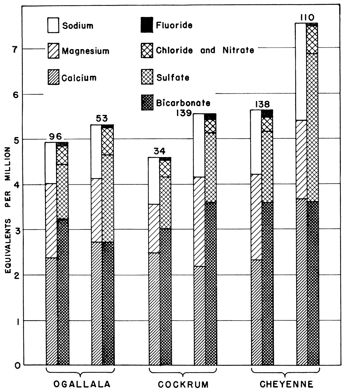
The water samples analyzed from the Ogallala formation contained 142 to 357 parts per million of hardness, the Cockrum waters 176 to 246 parts, and Cheyenne waters 203 to 379 parts. Because of the small number of samples from the Cheyenne formation, however, it is difficult to draw any conclusions as to the general range of hardness to be expected in these waters.
Prev Page--Geology || Next Page--Formations
Kansas Geological Survey, Geology
Placed on web Oct. 5, 2018; originally published November 1941.
Comments to webadmin@kgs.ku.edu
The URL for this page is http://www.kgs.ku.edu/Publications/Bulletins/37/05_gw2.html