![]()
Prev Page--Subdivisions--Wolfcampian || Next Page--Subdivisions--Guadalupian
Major Subdivisions, continued
Leonardian
Lithostratigraphic Units
The Kansas Geological Survey (Zeller, 1968; Sawin et al., 2008) divides the Leonardian rocks into the Sumner Group below and the Nippewalla Group above. This stratigraphic succession is shown in fig. 2. The former consists of three formations, in ascending order, the Wellington Formation with six members (two unnamed), the overlying Ninnescah Shale with two members (one unnamed), and the Stone Corral Formation. The Nippewalla Group consists of six formations with the Harper Sandstone and Blaine Formation subdivided into two and four members, respectively. In the subsurface the Wellington Formation, Ninnescah Shale, Stone Corral Formation, Blaine Formation, and Dog Creek Formation can be recognized, but the intervals between the Stone Corral and Blaine and the Blaine and Dog Creek are undifferentiated (Mudge, 1967, p. 109). The Stone Corral Formation is a very useful stratigraphic marker and has been used as the datum in numerous studies of the Permian in the Kansas subsurface.
Sumner Group
Wellington Formation--Marine, brackish, and freshwater fossils have been reported from the nearly 700-ft (214-m)-thick Wellington Formation with the marine deposits in the lower part (Zeller, 1968, p. 50). Three of the six members in the Wellington Formation are thin, argillaceous, dolomitic limestones: the Hollenberg and Carlton in the lower part and the Milan at the top of the formation.
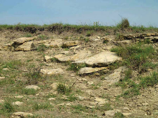
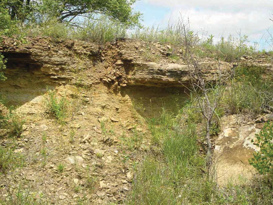
As reported by Zeller (1968, p. 50), the Hollenberg is 0.3-1.5 m (1-5 ft) thick, the Milan is up to 2.4 m (8 ft) thick, and the Carlton is lenticular (fig. 53). Fossil insects have been reported from the Carlton at some localities (Zeller, 1968, p. 50). The Milan Limestone Member is typically a succession of discontinuous, thin carbonate beds (Berendsen and Lambert, 1981; Watney et al., 2003).
Figure 53--Exposure of the Wellington Formation (Carlton Limestone Member) in a field on the south side of the road; near center of north line NW sec. 28, T. 16 S., R. 2 E., Dickinson County, Kansas.
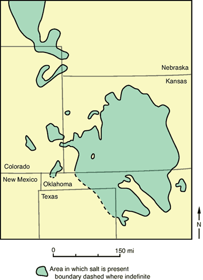
The two unnamed shale members of the Wellington separate the Hollenberg from the underlying Herington Limestone Member of the Nolans Limestone (Chase Group) and the Carlton from the Hollenberg. Overlying the Carlton and underlying the Milan is the thickest and economically most important member of the Wellington Formation, the Hutchinson Salt Member. The solubility of the salt precludes its exposure at the surface but it has been reported as 213 m (700 ft) thick in the subsurface of Clark County (Kulstad, 1959). The distribution of the Hutchinson Salt Member in Kansas is shown in fig. 54 (see also Watney et al., 1988). As noted by Mudge (1967, p. 109), the salt originally extended farther east but has been removed by erosion.
Figure 54--Distribution of the salt in the Wellington Formation in Kansas and adjacent areas (modified from Mudge, 1967, p. 109, fig. 37).
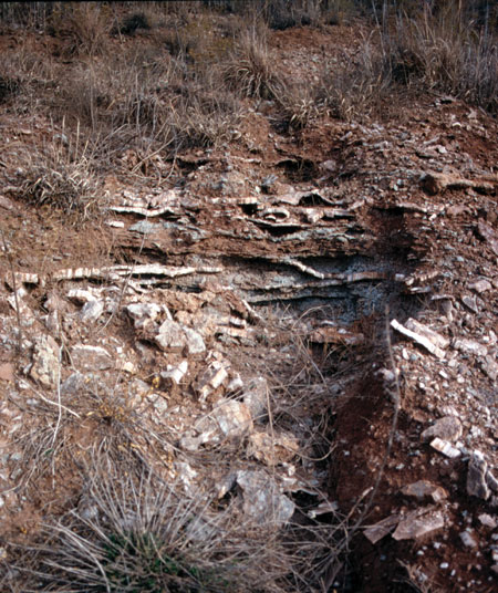
In general the lower part of the Wellington is gray anhydritic mudrock interbedded with anhydrite; the middle part, the thickest, is mostly red mudrock, anhydrite, and salt; and the upper part is interbedded gray anhydritic mudrock and red mudrock. The well-known and classic fossil-insect collection at Elmo, Kansas, the so-called "Elmo fossil bed" occurs along with plant fossils in the Carlton Limestone Member 76.2 to 91.4 m (250-300 ft) above the base of the Wellington Formation (fig. 55). An excellent synopsis of the history, biota, and literature of this classic locality at Elmo, Kansas, is given by Beckemeyer (2000). Beckemeyer and Hall (2005) and Hall et al. (2005) discussed the entomofauna and depositional aspects of these beds, respectively. Fossil insects, plant fossils, and conchostracans occur at several levels within the Wellington from Oklahoma well into Kansas (Tasch, 1958, 1961, 1963; Tanner, 1959; Tasch and Zimmerman, 1959, 1961). Tasch (1964) interpreted these as limnic deposits and described a paleolimnological cyclicity.
Figure 55--Gully exposures of the classic Elmo fossil insect beds, SW sec. 21, T. 16 S., R. 2 E., Dickinson County, Kansas.
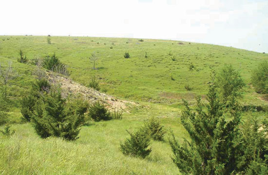
Ninnescah Shale--The Ninnescah Shale is 91.4 to 137.2 m (300-450 ft) of essentially red anhydritic, dolomitic, calcareous mudrock that thins to about 15.2 m (50 ft) in the subsurface near the Nebraska line (Zeller, 1968, p. 50-51; fig. 56). In northwestern Kansas, sandstones and sandy mudrocks are present, but interbedded salt, anhydrite, and mudrock occur in south-central and western Kansas where it is thickest (Martinez et al., 1996). Mudge (1967, p. 110, fig. 38) shows the distribution of salt in the Ninnescah Shale. Conchostracans ("clam shrimp") have been found in the non-red beds, and the "Red Jaw" country of Reno County is the result of the weathering of the middle part of this formation that contains calcareous concretions (Zeller, 1968, p. 50).
Figure 56--Exposure of the Ninnescah Shale in a road ditch looking northeast at the junction of K-14 and West Parallel Road; SW corner, sec. 34, T. 25 S., R. 8 W., Reno County, Kansas.
At the base of the Ninnescah Shale (Zeller, 1968) is an unnamed member that is overlain by the Runnymede Sandstone Member. The Runnymede sandstone is a 2-2.4-m (7-8-ft)-thick, gray to grayish-green siltstone to very fine sandstone (Zeller, 1968, p. 51). A disconformity separates this formation from the underlying Sumner Group and although the Runnymede is absent because of erosion in some areas, the Stone Corral Formation, which overlies the Runnymede, is commonly present (Rascoe, 1988). Rascoe and Baars (1972, p. 147, fig. 3) refer to this as an intra-Leonardian lacuna.
Stone Corral Formation--The Stone Corral Formation, at the top of the Sumner Group, is in surface exposures basically a dolomite to dolomitic mudrock with evaporites-anhydrite and gypsum (fig. 57). In the subsurface of south-central and west-central Kansas, near the depositional axis, the Stone Corral Formation includes thin halite beds that occur both above and below dolomite-anhydrite layers (Merriam, 1963). Because of the solubility of these evaporates, this unit is often vuggy in surface exposures. In the subsurface it may be mostly anhydrite (Mudge, 1967, p. 109). This 2-30.5-m (6-100-ft)-thick formation is an easily recognized "marker bed" in the red-bed sequence of Kansas.
Figure 57--Exposure of the Stone Corral Formation along the south side of Avenue Q, 1.6 mi (2.6 km) west of the McPherson/Rice County line; just west of the center of the north line, sec. 26, T. 20 S., R. 6 W., Rice County, Kansas.
Nippewalla Group
Harper Sandstone--Overlying the Stone Corral Formation is the Harper Sandstone, a formation 67.1 m (220 ft) thick of mostly red argillaceous siltstone and very fine silty sandstone (fig. 58). The two members, Chikaskia sandstone below and the Kingman sandstone above, are lithologically very similar. They are separated by a prominent 0.9-m (3-ft) bed of white, sandy siltstone.
Figure 58--Exposure of the Harper Sandstone in a bluff on the northwest side of US-54 east of Kingman, Kansas; near center sec. 33, T. 27 S., R. 7 W., Kingman County, Kansas; based on a section measured and described by A. Swineford on file at the Kansas Geological Survey.
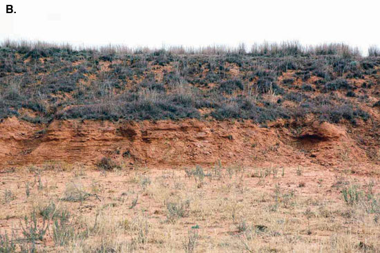
Salt Plain Formation--Above the Harper is the Salt Plain Formation, which is composed of silty mudrocks with beds of coarse silty sandstone (figs. 59A, B). Salt is associated with some of the mudrocks below the Crisfield sandstone bed in the lower part of the formation (Zeller, 1968).
Figures 59A, B--Exposure of the Salt Plain Formation looking north from near the center of south line, sec. 3, T. 32 S., R. 9 W., Harper County, Kansas; 59A is a general view of the exposure; 59B is a closer view of the sandy and silty beds; based on a section measured and described by A. Swineford on file at the Kansas Geological Survey; according to Bayne's (1960) geologic map of Harper County, this is an area where the Harper Sandstone and Salt Plain Formation are undifferentiated.
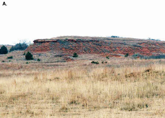
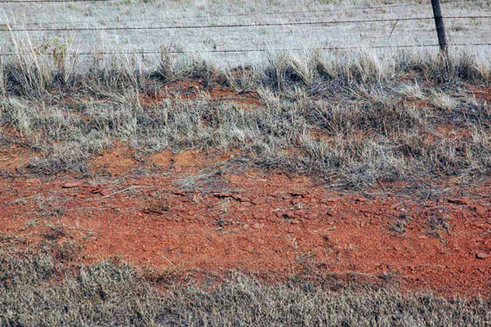
Cedar Hills Sandstone and Flower-pot Shale--Two formations are recognized above the Salt Plain Formation and below the Blaine Formation. These are the Cedar Hills Sandstone below (figs. 13, 60), and the Flower-pot Shale above (fig. 12). A thin, white sandstone at the base of the Cedar Hills separates it from the underlying Salt Plain. Both the Cedar Hills and Flower-pot are predominantly red mudrocks that contain gypsum (fig. 61).
Figure 60--Exposures of the Cedar Hills Sandstone along Gyp Hill Road looking southeast from near center of N/2 sec. 20, T. 32 S., R. 12 W., Barber County, Kansas.
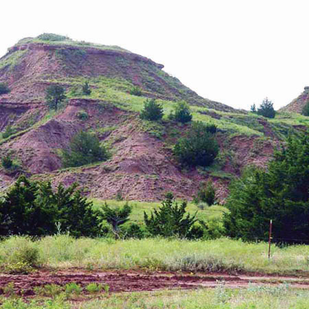
Figure 61--Natural outcrop of gypsum, upper Permian, Clark County, Kansas; from photo files of the Kansas Geological Survey.
Beds of gypsum are particularly conspicuous in the Flower-pot, as are thin beds of coarse siltstone and coarse to fine sandstone (fig. 12). Mudge (1967, p. 110) suggested that these coarser siliciclastics might be channel-fill deposits. The Flower-pot Shale contains up to 76.2 m (250 ft) of halite in northwestern Kansas in a localized basin called the Syracuse basin (Holdaway, 1978). The halite is distinctive, coarsely crystalline and clear, and has apparently displaced a red siltstone matrix, referred to as a chaotic red bed salt. The halite in the Flower-pot Shale is in marked contrast to the Hutchinson Salt Member that is typically a distinctively bedded, cloudy halite with thin continuous layers of gray mudrock. The distribution of salt in the Nippewalla Group is shown by Mudge (1967, p. 110, fig. 39) and is more extensive than the distribution of the salt in the Ninnescah Formation (Mudge, 1967, p. 110, fig. 38).
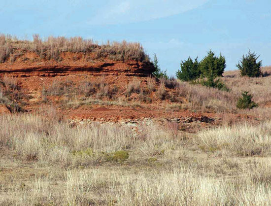
Blaine and Dog Creek Formations--The two uppermost formations of the Nippewalla Group are the Blaine below and the Dog Creek above (fig. 2). The Blaine Formation is essentially gypsum and anhydrite (Kulstad et al., 1956), but beds of gypsum and anhydrite also occur in the Dog Creek Formation. Thus, the base of the Blaine, and the top of the Dog Creek, are easily recognized in the subsurface, but it is hard to differentiate between the two; therefore, they are commonly lumped together in subsurface studies. Both are absent in northern Kansas, possibly as a result of pre-Jurassic erosion (Mudge, 1967, p. 110). The four gypsum members, separated by dolomite and red mudrock (Zeller, 1968, p. 52), compose the approximately 15.2-m (50-ft)-thick Blaine Formation (fig. 62). The Dog Creek is a maroon silty mudrock with siltstone; very fine grained, feldspathic sandstone; dolomitic sandstone; dolomite; and gypsum beds (Swineford, 1955, p. 91; Zeller, 1968, p. 52; fig. 15). Like the Blaine, the Dog Creek is up to 15.2 m (50 ft) thick, with 0.9 m (3 ft) of maroon mudrock normally occurring at the top, but locally, a red and white laminated gypsum bed 0.3 m (1 ft) thick can occur at the top (Zeller, 1968, p. 52).
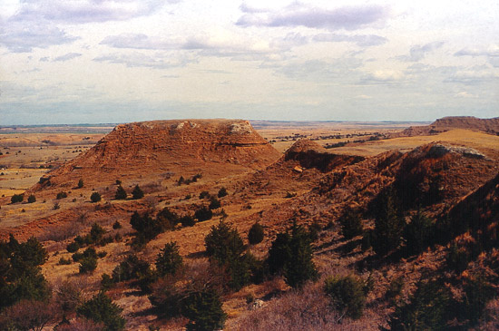
Figure 62--Permian red beds near Medicine Lodge, Barber County, Kansas; the light-colored "rim rock" is probably the Medicine Lodge Gypsum Member of the Blaine Formation above the red beds of the Flower-pot Shale; from photo files of the Kansas Geological Survey.
Upper Boundary of the Leonardian
A summary by Mudge (1967, p. 112 [his Interval B]) discusses the upper boundary of the Leonardian. As he pointed out, some argue the contact with the overlying Guadalupian rocks is conformable and others consider it a major unconformity. Difficulty in differentiating the Blaine from the Dog Creek in the subsurface does little to support either view. Mudge (1967) suggested that thinning of the Blaine and its absence, and that of the Dog Creek, in some areas is the result of wedging out rather than erosion. However, the Blaine Formation serves as an excellent regional marker bed in the subsurface, extending well north of Kansas into Wyoming and south through Oklahoma.
Lithofacies and Thickness of the Leonardian
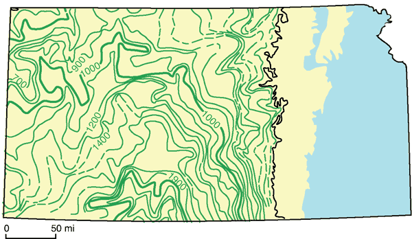
Siliciclastics and evaporites are the predominant Leonardian lithologies in Kansas, and their current thickness is largely the result of post-Permian (Mesozoic and Cenozoic) erosion. In northwestern Kansas the 106.7 m (350 ft) of Leonardian rocks are mainly sandstones, some siltstones, and evaporitic mudrocks. In south-central Kansas, where the Leonardian sequence is thickest, 731.5 m (2,400 ft), evaporites make up a large part of the succession; along the eastern outcrop, the rocks are largely evaporitic mudrocks. A well-log cross section (see Watney et al., 1988) encompassing the Leonardian extending from the updip landward margin to the thick axis of the depocenter indicates that the Hutchinson Salt Member composes most of Leonardian thickening with upper salt beds stepping basinward to the south. The Hutchinson Salt Member, although dominantly halite over much of its depositional area, grades southwestward to increasing proportions of anhydrite, a trend that continues basinward into Oklahoma. Halite thickness and proportions are greatest in central Kansas along a northwest-southeast elongated trend of thickening lying west of the city of Hutchinson and crossing the axis of the Central Kansas uplift. A thick correlatable anhydrite divides the Hutchinson Salt Member into an upper and lower interval. The depocenter of thick, clean halite in the upper Hutchinson Salt Member shifts southwestward relative to the lower interval, and the edges of the salt basin retreat basinward (southwest) indicative of regression (Watney et al., 1988). An isopach map of the Leonardian rocks in Kansas illustrates the large embayment centered in south-central Kansas (fig. 63); see Mudge, 1967, p. 107, fig. 35). Merriam (1963, p. 90, fig. 40) illustrated the lithologic variation of the Stone Corral Formation. The area of thick Leonardian rocks more or less parallels the western side of the Central Kansas uplift, the axis of the Kansas depositional basin (Mudge, 1967, p. 113). Leonardian rocks are also thicker in the Hugoton embayment after thinning slightly along the western edge, the Selden anticline, of the Kansas depositional basin (Mudge, 1967, p. 112).
Figure 63--Isopach map of Leonardian rocks in Kansas; contour interval = 100 ft, poor control where dashed; rocks older than Permian exposed in blue area (modified from Mudge, 1967, fig. 35, p. 107).
Depositional Environments and Source Areas of the Leonardian
Although some Leonardian rocks occur in the Salina and Sedgwick basins, they are particularly significant in the Central Kansas uplift, Kansas depositional basin (see Mudge, 1967), and Hugoton embayment. These three features were the major parts of a large depositional basin during Leonardian time and received siliciclastic sediment from two major source areas: the Front Range, especially the Wet Mountains, to the west, and Siouxia landmass to the north and northwest. Leonardian rocks originally covered a much larger area, but the area was reduced by post-Permian erosion. Swineford (1955, p. 164) indicated that most of the immature siliciclastics, such as feldspathic sandstones, came from the Wet Mountains. Mudge (1967, p. 113) suggested that some feldspathic debris could have come from the south and cited Swineford (1955, p. 164-166) as indicating that the coarseness of these siliciclastics increased in a southern direction and that certain grains were typical of second-cycle orthoquartzites, i.e., they might have had a Cambrian-Ordovician source. The Siouxia landmass supplied finer siliciclastics such as silt, very fine grained sand, and clay. It has been suggested that some of these finer siliciclastics are a result of eolian deposition (Parrish and Peterson, 1988; Johnson, 1989; Soreghan, 1992; Ziegler et al., 1997; Ziegler et al., 1998; Mack et al., 2003).
Structural features controlled the environments of deposition of Leonardian rocks (Mudge, 1967, p. 113). In general these environments alternated between marine, brackish-water, and continental, with coastal and continental environments becoming more dominant as the climate became more arid, and circulation more restricted, as the area was periodically isolated from the open ocean. The distribution and relationship between the different depositional environments inferred during Leonardian time is shown in fig. 64 (see McKee and Oriel, 1967, Plate 10A). Obviously, evaporation of marine water was a dominant process given the thick salt beds and the numerous beds of gypsum and anhydrite. Coastal-marine, alluvial and fluvial, and eolian environments are represented. Coastal-marine and fluvial deposits occur along the edges of the basin and near smaller, local source areas (islands). The basin was essentially a large alluvial plain with little relief. Of course, eolian deposits would have accumulated over the entire area, and this mechanism is now receiving more serious consideration as the depositional agent of the finer (silt and clay) siliciclastics.
Figure 64--Depositional environments during the Leonardian in Kansas (modified from McKee and Oriel, 1967, plate 10A).
Apparently the Syracuse basin developed in the late Leonardian creating accommodation space for the pronounced thickening of the Flower-pot Shale and associated halite. This basin is bordered by current-day structural features on the east (Oakley anticline) and on the west (Los Animas arch), representing a westerly shift in subsidence on the Kansas shelf, perhaps indicating further southwesterly migration of tectonism to the south.
Application of sequence stratigraphy to Leonardian rocks in Kansas is limited, and few have attempted to document the cyclicity of this stratigraphic interval. Mudge (1967) recognized two major cycles in the Kansas Leonardian, one from the top of the Wolfcampian to the top of the Stone Corral Formation and the other from the top of the Stone Corral Formation through the Dog Creek. "Each cycle closed with prolonged and widespread deposition under restricted-marine conditions" (Mudge, 1967, p. 114). The alternation of depositional conditions produced many small-scale cycles, but these have rarely been documented in detail. Tasch's studies (1958, 1961, 1963, 1964) of limnic sequences and his documentation of paleolimnological cycles is an obvious exception, as is the more recent study by Watney et al. (1988) on the origin and distribution of the Hutchinson Salt Member.
Using cores through the Hutchinson Salt Member, Watney et al. (1988) documented a high-frequency depositional cyclicity consisting from bottom to top of 1) a thin magnesite/dolomite bed, 2) a thin anhydrite bed, 3) a succession of thicker halite beds, and 4) a thin, gray silty mudrock bed often containing fractures filled with polyhalite and anhydrite. The thicker halite beds in number 3 above range from well-bedded, cloudy, fine- to medium-crystalline halite interrupted by multiple, thin, dark-gray mudrock beds to salt beds consisting of halite of varied crystal size with patches of clear large halite crystals and an irregular upper surface with occasional dissolution pipes or microkarst surfaces. The lower halite beds typically contain hopper and chevron halite crystals indicating primary deposition of halite crystals formed at the surface of the brine (hoppers) and on the seafloor (chevrons). When seen in roofs of the salt mines, discontinuous fractures in the cycle-capping mudrock bed (number 4 above) often form large meter-scale polygons, probably due to desiccation. The salt mines are located along the landward edges of the Kansas Permian salt basin where one would expect to find desiccation features. Dissolution along the upper surface of the halite beds may be related to either desiccation or influx of low-salinity water from runoff along the periphery of the salt basin.
The typical thickness of the halite-dominated cycles in the Leonardian is less than 15.2 m (50 ft), which is similar to those of underlying Wolfcampian carbonate-dominated cycles. Similar thicknesses of these marine cycles coupled with indications of rapid marine inundation and slower regression suggest that these halite cycles represent the continuation of a eustatic cycle similar to those in the Wolfcampian. However, restricted circulation in the Leonardian is inferred to have led to dominant hypersaline subaqueous conditions during each cycle accompanied by intermittent subaerial conditions, a feature common to both periods of time. The thin magnesite/dolomite and anhydrite bed at the base of the cycle likely represents transgressive to highstand marine conditions. Halite beds accumulated in a shallowing, hypersaline water body. Mixing with more-open-marine waters from the Permian seaway to the south precluded precipitation of potash salts in any of these cycles in Kansas. Limited occurrences of polyhalite accumulated as thin irregular beds and fracture filling during deposition of the upper halite beds suggesting maximum salinities were only slightly higher than that required for halite precipitation (Jones, 1965).
Correlation and subsurface mapping of the Hutchinson Salt Member, using over 3,700 wells, recognized six carbonate and anhydrite markers that delineate the transgressive bases of cycle sets. These marker beds represent periods of more prolonged and extensive open-marine (less-hypersaline) conditions. Each cycle set contains five or six higher-frequency cycles that are believed to be comparable to cycle sets in other Permian and upper Carboniferous (Pennsylvanian) strata (Watney et al., 1995).
The abrupt shift from carbonate-dominated Wolfcampian cycles to Leonardian halite cycles is attributed to rapid shallowing of the Palo Duro and Dalhart basins as they filled with sediment as tectonic subsidence decreased at the end of Wolfcampian (Hanford and Dutton, 1980). These southern basins continued to provide access of marine waters from the Permian basin to the Kansas shelf, but return circulation was restricted enough to produce increasingly hypersaline brines in most distal sectors of the basin in Kansas. This is consistent with the reflux model of Scruton (1953).
Depositional cycles are developed above the Hutchinson Salt Member in the upper Wellington and Ninnescah shales. These cycles consist of thin anhydrite or dolomite beds indicative of flooding followed by accumulation of marine mudrocks (Watney et al., 2003). The cycles are capped by poorly studied, variegated paleosols containing desiccation polygons, breccias, and ped structures. Halite accumulation in the Ninnescah Shale is limited to southwestern Kansas indicating a continued basinward shift in marine lithofacies and relative fall in sea level through the base of the Runnymede sandstone.
Recognition of paleosols requires carefully detailed study of lithologic characteristics. Such studies would enhance a sequence-stratigraphic approach and would provide some much needed information on the climate during this time interval. Thus, there is ample opportunity for further study of this interesting and challenging sequence.
The regionally significant Runnymede sandstone and Stone Corral Formation reflect a major marine inundation unconformably overstepping the "lowstand" marginal-marine to nonmarine red beds of the Ninnescah Shale. The Runnymede sandstone contains lithofacies consistent with eolian and fluvial deposition and may be the result of a climate change associated with a rise in sea level. Continued rise in sea level led to halite accumulation of the lower Cimarron Salt beds (Martinez et al., 1996) and the anhydrite and dolomites of the Stone Corral Formation. The succeeding red beds of the Nippewalla Group represent regressive conditions dominated by eolian siliciclastic and nonmarine evaporite accumulation across broad saline areas that were isolated from the marine source to the south.
The Blaine Formation, Flower-pot Shale, and Cedar Hills Sandstone represent another major marine inundation that overstepped the predominantly red-bed, nonmarine succession of the Nippewalla Group. Mobilized sand and a rising water table led to preservation of extensive deposits of the Cedar Hills Sandstone, equivalent to the widespread Glorieta Sandstone of Texas and New Mexico (Presley and McGillis, 1982). The Flower-pot Shale is a red-bed deposit containing a halite succession limited to western Kansas in the Syracuse basin where thicknesses are upwards of 76 m (250 ft; Holdaway, 1978). The basin was delimited by the Oakley anticline on the east, the Las Animas arch on the west and north, and a thick accumulation of Cedar Hills Sandstone on the south. Displacement growth of large, clear halite crystals in the silty red mudrocks of the Flower-pot Shale, isolation of the Flower-pot halite from a marine source, and low (<1 ppm) bromine content of the halite indicative of recycled halite support a nonmarine-halite accumulation. Halite was precipitated in the basin center through evaporation of hypersaline ground water. Again, climate change, concurrent with a sea-level rise, may have led to the rise in the water table (i.e., more rainfall). Eventually, marine transgression occurred, resulting in deposition of the regionally extensive anhydrite and dolomite of the Blaine Formation. The marine transgression associated with the Blaine Formation advanced onto the craton as far north as Wyoming.
Prev Page--Subdivisions--Wolfcampian || Next Page--Subdivisions--Guadalupian
Kansas Geological Survey, Geology
Placed on web April 27, 2010; originally published April 2010.
Comments to webadmin@kgs.ku.edu
The URL for this page is http://www.kgs.ku.edu/Publications/Bulletins/257/05_subd_2.html