Kansas Geological Survey, Bulletin 233, p. 44-62
by
Harold R. Wanless
Division of Marine Geology and Geophysics, Rosenstiel School of Marine and Atmospheric Science, University of Miami
The design of useful models for predicting sequences and facies patterns of sedimentary cycles depends on an observational foundation that includes the recognition and adequate understanding of fundamental depositional sequences. Six facets must be met. The modeler must have (1) adequate documentation of sequence character; (2) adequate characterization of spatial and directional variability and continuity of facies; (3) an adequate database on the influence of primary and secondary controls on sedimentation; (4) an understanding of interaction of controls on sedimentation; (5) an understanding of limits of physical, biologic, and chemical influences; and (6) an understanding of diagenetic modifications to sequence nature and thickness. In addition, the models should work from the fundamental depositional sequence. The modeler should use caution in applying models designed for one scale of sedimentary sequence to another scale. Examples illustrate the necessity for meeting each facet.
An Acrobat PDF file containing the complete paper is available (1.7 MB).
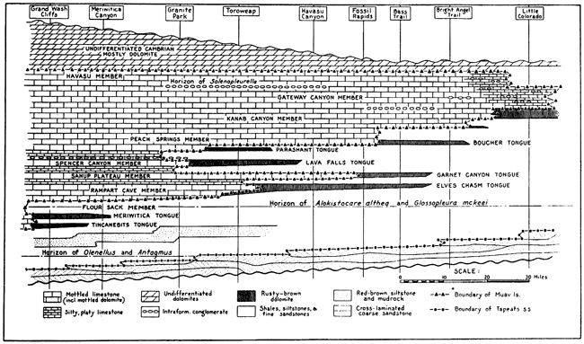
The late Edwin McKee conducted an extensive stratigraphic study of the Cambrian of the Grand Canyon along its length (McKee, 1945). He discovered two important things. First, he recognized repetitive shaly to nonshaly sequences with sharp caps--what we now would call cycles. Second, using fossil assemblage zones and stratigraphic units, he also found that distinctive outcrop features, such as the rusty-brown (crinoidal) dolomite cliffs in the western Grand Canyon, were separate lithologic units of a different age than the rusty-brown dolomite cliffs in the eastern Grand Canyon (fig. 1). McKee demonstrated through paleontologic evidence that these individual sequences were correlatable for 100-200 km (60-120 mi) across depositional strike but were diachronous--a time-transgressive sequence of the Middle Cambrian. These were important foundations.
Figure 1--East to west stratigraphic cross section of the Cambrian of the Grand Canyon, Arizona, from McKee (1945). By using traceable faunal and lithologic horizons, McKee showed that the sequence was time transgressive. Cycles within the sequence are equivalent to grand cycles and contain smaller fundamental depositional sequences. Thickness varies from 800 ft (240 m) in the east (right) to 1,500 ft (460 m) in the west.
Today we recognize that McKee's cycles, which are 10-70 m (30-230 ft) thick, are actually groupings of smaller-scale cycles (fig. 2; Wanless, 1973a,b). These smaller, 1-10m-thick (3-30-ft-thick) cycles represent the fundamental depositional sequence or cycle of sedimentation. Shale content decreases upward in each fundamental depositional sequence, and each has a sharp cap. Each of these fundamental depositional sequences appears to represent a shallowing-upward cycle (A → B), and many are capped by an exposure surface (C). Each fundamental depositional sequence can be correlated laterally, but the facies change across depositional strike (fig. 3). The upper parts of the cycles vary from fine silicic sands to glauconitic sands to skeletal and peloidal calcarenites to clean carbonate muds.
Figure 2--The Cambrian of the Grand Canyon is organized into a series of grand cycles, basically equivalent to the sequences recognized by McKee (1945). Each grand cycle contains a series of 1-8-m-thick (3-26-ft-thick) fundamental depositional sequences. These fundamental depositional sequences are cycles containing a sharp base, a lower shaly unit (a), an upper nonshaly unit (b), and a cycle cap (c). Shaly units dominate the fundamental depositional cycle in the lower part of a grand cycle. Nonshaly units dominate the upper portion of a grand cycle. See fig. 3 for facies types and lateral variability of the fundamental depositional sequence.
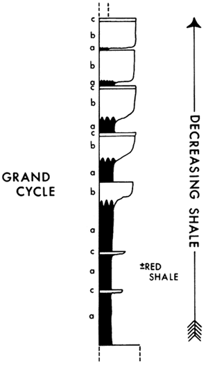
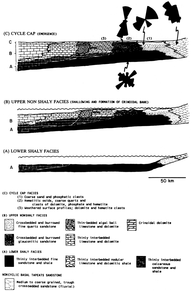
Figure 3--Individual fundamental depositional cycles in the Middle Cambrian of the Grand Canyon, Arizona, can be traced and correlated laterally across depositional strike. Each cycle increases in thickness from 1-3 m (3-9 ft) in the east (right) to 3-8 m (9-26 ft) in the west. The facies character of the lower (shaly) part of each cycle has a gradual lateral gradient. The upper nonshaly part of the cycle contains more pronounced lateral facies variation from fine quartz and glauconitic sands in the east to crinoidal and algal-ball limestones and dolomites in the middle to increasingly clean limestones to the west. Cycle cap facies represent exposure conditions (Wanless, 1973b). Paleocurrents are shown for the lower shaly units (as ripple crest trends) and the upper fine sandstone and glauconitic sandstone units (as crossbed dip directions). These marine facies are in marked contrast with the paleocurrent flow direction from the trough crossbedded basal Tapeats Sandstone of fluvial origin.
Fundamental depositional cycles commonly group into larger-scale sequences or cycles [grand cycles of the Middle and Upper Cambrian of southern Canadian Rocky Mountains (Aitken, 1966) and lower Paleozoic of the central Appalachians, eastern United States (Read, this volume)].
Although McKee's aggregate cycles and the grand cycles of Aitken (1966) contain a number of smaller fundamental depositional sequences of decreasing shale upward, the deeper shaly facies (A) dominate in the lower part of the aggregate or grand cycle and the shallower nonshaly facies (B) dominate in the upper part (fig. 2). Facies related to exposure (C) may cap the aggregate cycle. A random sampling through an aggregate or grand cycle would very likely miss the contained fundamental depositional sequences and would likely produce a confusing sequence of sedimentation. In fact, each fundamental depositional sequence in the Grand Canyon Cambrian strata is a shallowing-upward sequence, and many are capped by an exposure surface. The aggregate cycles are easily seen and traced from distant overviews of the Grand Canyon; the fundamental depositional sequences are seen only by detailed documentation of the complete sequence in steep, well-exposed outcrops or core borings.
Here, a fundamental depositional sequence is considered the smallest subdivision of lithofacies assemblages that includes the main recurring lithofacies. As such, it records the basic sequence of processes and environments that constitute the larger sequence. A fundamental depositional sequence may or may not be cyclic. The fundamental depositional sequences or cycles of sedimentation are the fundamental lithologic building block or sequence unit of stratigraphic sequences. As such, they are the unit from which cyclic (or noncyclic) sedimentation, basin architecture, and sequence stratigraphy must be modeled.
The term "parasequence" is a parallel term but has been avoided here because it is formally tied to sea-level dynamics, not defined with respect to scale, and is commonly used as a seismic expression of the basic unit of sedimentation. Similarly, the term "punctuated aggradational cycle" (PAC) (Anderson and Goodwin, 1978) is not used because it implies a genetic relation to sea-level change. Parasequence and PAC are specific interpretive types of fundamental depositional sequences. The building block for modeling must be based on lithologic sequences and should not be formally tied to any one depositional influence.
It should be recognized that some sequences may be composites of more than one fundamental depositional sequence or cycle. These interfacing sequences may or may not be in phase or of the same duration. For example, constructional-destructional phases of lobes of a prograding delta produce one group of fundamental depositional sequences; sea-level rise and fall may produce another (different time scales, no phasing relation). Or, ice-rafted sediment related to a cycle of polar ice buildup may interface with shelf or slope sedimentation influenced by sea-level rise and fall (same period of influence but not necessarily in phase).
In some sequences, event units (tempestites, turbidites, slumps) distinctly occur within fundamental depositional sequences (tempestites as part of a shallowing-upward sequence) or contain vertical trends in the nature of event units (sequence of fining-upward tempestite units). Other sequences may not display clear fundamental depositional sequences but may be composed of numerous event units. Finer-scale event sedimentation units may not be conducive to predictive modeling, especially if the driving forces are episodic.
It is my goal in this article to offer some guidance for the recognition of the small-scale fundamental depositional sequences or cycles of sedimentation and to provide an awareness of the variety of depositional factors that can dramatically influence the nature of the preserved facies and fundamental sequence. It is hoped that this will lead to improved modeling of sequences of sedimentation.
To get at the nature, variability, and meaning of the small-scale fundamental depositional sequences, it is necessary to look at three groups of observational foundations: descriptive characterization, understanding of influences, and incorporation of diagenetic modifications. Most fundamental to descriptive characterization is proper and adequate (1) characterization of the real-world sequences and (2) their lateral variability. To model a descriptive sequence so that its influences can be understood, one needs a good understanding of (3) the nature of controls on sedimentation, (4) the effects of their interaction with one another, and (5) the limits of a control's influence. Finally, one needs to have a good understanding of (6) diagenetic modifications to the nature of the sequence and to its thickness. Rather than trying to give an overview with lists of hundreds of things that might be influential, a few specific examples are offered under each observational foundation topic. Most are within my experience. Some examples are a bit unusual but should serve to titillate the reader's imagination for improved modeling efforts.
Sequence characterization must include (1) proper definition of the fundamental depositional sequence; (2) adequate statistical characterization of the vertical sequence; (3) proper definition of sequence boundaries; (4) definition of lateral facies continuity and boundaries; (5) clear differentiation of transgressive, regressive, and stillstand facies; and (6) differentiation of sheet deposition versus bank-mound-ridge accumulation of facies. This characterization must be based on lithologic studies of outcrops and/or cores. To build sequence models entirely on interpreted seismic information is to build models from models--most likely a house of cards.
Research on sequences should begin with proper documentation of the lithologic nature and variability of the fundamental depositional sequences, adequately evaluating the depositional environments and processes recorded by those sequences.
Example--At a recent conference on Mississippian oolites, Hunter (1989) led a portion of the field trip to the Ste. Genevieve Limestone in Indiana and offered strong evidence that significant portions of the shallowing-upward oolite cycles were eolian. This recognition revises the nature of the fundamental depositional sequence, completely changes the spatial relations of environments, changes conclusions about environments of ooid production, sediment budget, and transport processes, and thoroughly revises the possibilities for early diagenetic changes. It is thus important not only to recognize the fundamental depositional sequence but also to understand what it represents.
It is extremely important to determine whether a cyclic sequence really exists.
Example--In the "golden bible" of cyclic sedimentation (Merriam, 1964), several vertical ("stratigraphic") number sequences were taken out of the Lawrence, Kansas, telephone book, and geologists unwittingly generated cycles from these number sequences and then correlated them (Zeller, 1964). Some sequences have only motifs or patterns (Walker and Harms, 1971) but not cycles or trends.
In several cases sequences have been termed fining upward (because that is the type of sequence with which the geologist was familiar) when, in fact, the sequences are coarsening upward and the cycle boundary has been improperly placed. A supratidal facies zone can easily be called a cap to a shallowing-upward cycle, whereas it may actually represent either the transgressive beginning of a cycle or partly the cap of one cycle and partly the beginning of the next cycle of sedimentation.
It is crucial to understand how sequences and facies within a sequence laterally interrelate and change.
Example--The dramatic Waulsortian-type mud mound buildups of New Mexico are discrete features with a patchy distribution, high relief, and abrupt lateral boundaries with other facies (flanking grainstones) (Wilson, 1975). In contrast, the dolomitic crinoidal and algal-ball facies in the cyclic Cambrian of the Grand Canyon are broad, low-relief features (figs. 1 and 3). They are 1-5 m (3-16 ft) thick, laterally continuous (perhaps for hundreds of kilometers) along depositional strike, and 15-30 km (9-20 mi) wide perpendicular to depositional strike with gradational boundaries with the landward glauconitic sandstone facies, the seaward bedded limestone facies, and the underlying thinly interbedded sandstone and shale facies. One must model the nature and influence of these two buildups differently because of their different sediment body geometry, form, continuity, scale, and lateral boundaries.
Perhaps the most difficult problem is differentiation of transgressive, stillstand, and regressive deposits.
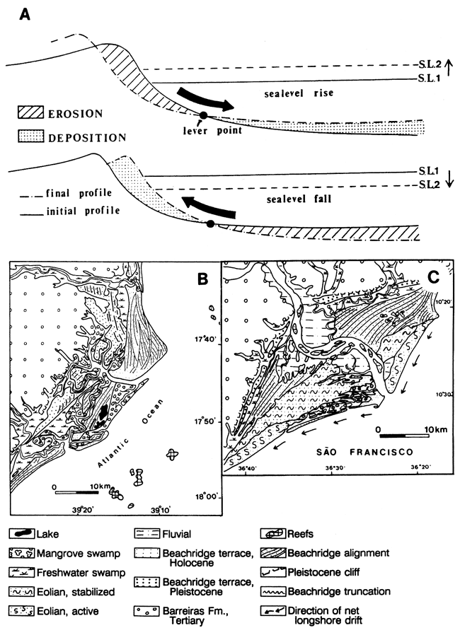
Example--In many models of clastic strand-plain sedimentation, current thinking is that sea level rises and then sedimentation (aggradation and progradation) occurs during a stillstand (Vail et al., 1977). In fact, Bruun's rule suggests that a significant portion of inner shelf sedimentation should occur during a rise in sea level (as sand is transferred from the shoreface to a deepening inner shelf) (Bruun, 1962; Schwartz, 1967; Swift, 1968; Dominguez, 1987; Dominguez, et al., 1987) and that shoreface progradation should occur during stillstand (longshore sediment supply) or falling sea level (sand transfer from the shallowing inner shelf to the shore) (Dominguez, 1987; Dominguez et al., 1987). Although erosion of the shoreface occurs with sea-level rise, the deepening inner shelf provides accommodation for sediment accumulation. This deposit of transgressive shelf sand may become an important part of the sedimentary sequence (fig. 4a). Dominguez (1987) and Dominguez et al. (1987) have shown this to be the case for the Holocene shelf and strand-plain sequence in Brazil. Transgressive and regressive shelf sand deposits can become an amalgamated subtidal sand unit that would be easy to misinterpret as entirely regressive, especially if the shelf was shallow. Calculated rates of sediment supply and the nature of facies deposition are different if deposition occurs during transgression.
Figure 4--(A) Application of Bruun's rule to rising (top) and falling (bottom) sea level [from Dominguez (1987)]. Landward-migrating barrier islands and shelf accretion characterize rising sea level as sand is transferred from the shore face to the inner shelf to restore an equilibrium profile; strand-plain progradation and shelf erosion characterize lowering of sea level as sand is transferred shoreward from the inner shelf in an effort to maintain a profile of equilibrium. (B) Sedimentary environments on Caravelas beach-ridge plain, southeastern coast of Brazil, a strand plain not directly associated with a river mouth [from Dominguez et al. (1987)]. (C) Sedimentary environments on Sao Francisco beach-ridge plain, eastern coast of Brazil. Progradation is associated with times of lowering relative sea level.
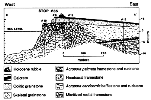
Example--It is also important to understand that there are expected facies successions that occur with time within transgressive, stillstand, and regressive deposits. For example, the Pleistocene and Holocene of the western portion of Caicos platform (southeast Bahamas) contains three reef to oolitic grainstone sequences (fig. 5) (Wanless et al., 1989). The two Pleistocene reef to ooid sequences are capped by calcrete exposure surfaces. Each sequence is a single cycle of sedimentation in which initial reef growth is eventually overwhelmed and smothered by oolitic sand. I have observed this reef to ooid sequence from the Lower Cambrian archaeocyathid banks to the Holocene. Some researchers have suggested the choice is reefs or ooids (Perkins, 1986) rather than reefs, then ooids. Models will differ greatly depending on the path chosen.
Figure 5--Lithostratigraphic cross section on shore of Boat Cove, West Caicos, at western margin of Caicos platform based on cores and underwater outcrops. Two Pleistocene reef to ooid sequences are recorded, each capped by an exposure calcrete. The nearby Holocene marine sediments are producing a third shallowing-upward reef to ooid sequence [from Wanless et al. (1989); see "R" in fig. 9 for location].
Example--Heckel (1978, 1983) has attempted to differentiate shoal carbonates formed by late highstand from carbonates formed during the following transgression. He has used stratigraphic relationships, succession of conodont biofacies, and diagenetic characteristics to differentiate transgressive and regressive portions of the cycles in the Pennsylvanian Captain Creek Limestone Member of southeastern Kansas. Transgressive facies include basal stromatolites, oolite, and phylloid mound facies and an absence of marine or meteoric diagenesis. Regressive carbonates record marine and meteoric diagenesis.
It is important to understand whether a deposit has the form of a sheet or a mound.
Example--The dolomitic crinoidal and algal-ball facies of the Grand Canyon Cambrian occur between the seaward bedded limestones and the landward glauconitic sandstones (fig. 3). The crinoidal and algal-ball facies appear to have formed as a broad, shallow bank. This dolomitic crinoidal bank appeared part way through a depositional cycle (fig. 3) and served largely to block the seaward transport of fine-grained sands and muds and to isolate a broad inner lagoon of glauconitic and quartz sands from the outer platform of carbonate deposition. Fine siliciclastic sand and glauconite extend westward into the dolomitic crinoidal facies and fade out. Crossbedded glauconitic and quartz sands in the inner lagoon are oriented in a north-south longshore direction, indicating energy for clastic sediment transport but seaward restriction to flow. The algal-ball facies formed as a synchronous or subsequent prograding seaward flank to the crinoidal bank. Recognition that a facies forms as a shoal bank rather than as a simple subtidal sheet greatly modifies the influence one must give to it in a sedimentary model. Exposure features may cap the inner clastic and bank parts of the cycle, and shale of the subsequent cycle can spread across the entire sequence, marking the synchronous initiation of a new cycle of sedimentation.
Example--This problem becomes particularly evident when evaluating why the carbonate sediments of the Great Bahama Bank form a broad subtidal sheet deposit, whereas those of Florida Bay and Biscayne Bay are organized into a variety of mound or bank complexes (fig. 6) (Wanless and Tagett, 1989; Wanless et al., 1989). The answer appears to lie in the influence of preexisting topography on circulation and sedimentation and the rates of flooding of the platforms. The Great Bahama Bank was inundated 5,500-7,000 years ago when the rate of relative sea-level rise was greater than 5 m (15 ft) per 1,000 years. During this time of flooding, topographic irregularities had such a rapidly changing influence on sedimentation that they had little overall influence on it. In contrast, Florida Bay and Biscayne Bay were inundated during the past 4,500 years when relative sea level was rising at less than 2.5 m (8 ft) per 1,000 years. Much of the growth of the south Florida mudbanks has been during the past 3,000 years, in association with a sea-level rise of less than 0.5 m (1.6 ft) per 1,000 years. These slower rates of sea-level rise have permitted shallowly submerged topographic irregularities to have a more prolonged, persistent influence on patterns of sedimentation. This appears to have been the primary cause for initiation and growth of south Florida's carbonate banks (Wanless and Tagett, 1989).
Figure 6--Zones of different dynamic growth history of carbonate mudbanks and coastal storm levees caused by differences in sediment supply, energy, and sea-level history in Florida Bay. Stratigraphic cross section A-A', across Russell Bank in central Florida Bay, is a migrating bank dominated by layered carbonate mudstone. Stratigraphic cross section B-B', across Dildo Key mudbank in western Florida Bay, shows that this broad bank initiated as four core banks of layered mudstone. Subsequent sedimentation filled the shallow bays in between, creating a broad coalesced bank. Map and cross sections are from Wanless and Tagett (1989).
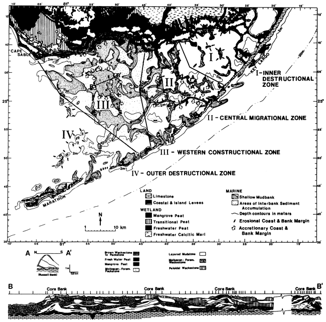
In addition, Florida Bay contains several different bank types. In central Florida Bay the banks are rather narrow (a few hundred meters wide) and are dynamic, actively migrating features. In cross section the mudbanks of central Florida Bay display southward- and westward-dipping stratigraphic units, indicating that the banks are migrating (fig. 6, cross section A-A'). In contrast, the mudbanks in western Florida Bay are as much as several kilometers across, and in stratigraphic cross section (Wanless and Tagett, 1989) it can be seen that bank size is due to the coalescence of several smaller core banks of layered mudstone resulting from infilling of the shallow interior basins (fig. 6, cross section B-B). Bank coalescence results from excess sediment input from the shelf to the west (James, 1984) and more intense sediment production associated with more open marine waters (Wanless and Tagett, 1989). These individual and coalesced banks would be extremely difficult to recognize in outcrop or core borings of ancient rock sequences because of the scale [1-2 m (3-6 ft) of relief over 0.5-3 km (0.3-2 mi)]. Nevertheless, they are banks, and they influence the nature of sedimentation in adjacent facies.
Accurate portrayal of the spatial and directional variability and continuity of facies and facies attributes is fundamental to modeling. Spatial variability of a facies and of fundamental depositional sequences reflects the nature of sedimentary processes, produces a spatial variability of diagenetic potential, and defines spatial continuity and variability in relation to economic resource distribution. Variability includes intracycle and intercycle variations in facies type, morphology, and growth habit with orientation of platform margin, coastline, or sediment body; intercycle variations in lateral facies shifts with variations in orientation; variations in early diagenesis with orientation; and variations in emergent topography with orientation.
An excellent example of how facies vary with position and orientation on a platform is seen in contrasting the tidal flat deposits of Andros Island, Great Bahama Bank; Caicos platform, British West Indies; and Chub Cay, Great Bahama Bank.
On Andros Island, the tidal flats face the platform interior to the west and northwest. Northwest wind pulses behind winter cold fronts provide repetitive bursts of onshore flooding of sediment-laden water onto the flats (Hardie, 1977). As a result, there are well-developed shore and channel-margin levees in which millimeter-thick laminae dominate (Hardie, 1977; Wanless, 1969). These levees and laminae are the result of frequent small sedimentation events (1-20 per year) that create a high levee profile of algal-bound millimeter-thick laminae. This influence dies out inland across the flats, and the inner pond and inland marsh receive sedimentation events only during major storms. Sediments of the inner marsh are similar to those described from Caicos platform.
The tidal flats of Caicos platform face the platform interior but, in contrast to Andros Island, face the south (Wanless, Tedesco, and Tyrell, 1988; Wanless et al., 1989). Northwesterly winds, following the passage of winter storms, blow off the Caicos flats, and winter storms produce no depositional events. The tidal flats over most of Caicos receive sedimentation events only during hurricanes (average of 1 every 5.5 years; Neumann et al., 1978). Hurricanes deposit centimeter-thick layers of carbonate grainstone or packstone and generate broad, low-relief levees (Wanless et al., 1988). The longer time between events permits a more mature algal-cyanobacterial marsh community and a thicker organic mat to form across nearly the entire flat. Orientation on a platform interior thus defines bedding character and organic content of a carbonate tidal flat. Similarly, the Southwestern portion of Andros Island faces southwest, is not a focus of frequent sedimentation events by winter storms, and has a broad, continuous shore levee built by less frequent hurricane flooding events.
On Chub Cay a tidal-flat setting occurs as a south-facing shore embayment, but one facing a narrow, sediment-starved platform margin. Here, there is an insufficient source of fine-grained carbonate sediment adjacent to the flat, and the sediment on the flats is entirely red mangrove peat (Wanless, 1974).
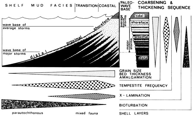
The spatial variability can result from one process, where the intensity of that process varies spatially. For example, the coarse tempestite deposits on the shelf of the Helgoland Bight (fig. 7) (Aigner and Reineck, 1982) display dramatic changes in texture, bed thickness, structure, and abundance, from proximal amalgamated sand beds to distal scattered sand layers in a shelf mud.
Figure 7--Lateral variation of tempestite influence on sedimentation from the shoreface to the deeper (distal) shelf of the Helgoland Bight, North Sea [from Aigner and Reineck (1982)].
Primary controls on sedimentation include sea-level dynamics; sediment supply; topography and physiographic setting; relative importance of prevailing energy, winter storms, hurricanes, ocean swells, and tides; tectonic pulses, flexures, and hinges; and climate, especially rainfall and temperature. These primary controls define a variety of secondary controls, including organism communities, biogenic sediment production, and water circulation and renewal. Lack of proper consideration of any one primary control can negate the validity of the resulting models. In this regard it is unwise to apply recognized controls on clastic sedimentation to carbonates and vice versa. Clastic and carbonate processes are commonly out of phase with respect to sea level.
It is easy to generate diagrams and lists summarizing the influences on sedimentation and sequence character. It is much more difficult to turn these into meaningful applications to a model.
Wright and Coleman (1973) offered a model, which has become widely used, to explain delta form and therefore the very nature of delta sequences. In this model they weigh the fluvial sediment discharge against reworking by waves [and other influences (Coleman and Wright, 1975)] to determine delta morphology, profile, and sediment type from the birdfoot delta of the Mississippi River as the muddy end member to the stacked strand-plain complex of the Sao Francisco River in Brazil as the coarse end member. They did not consider the role of sea level.
Dominguez (1987) and Dominguez et al. (1987) have subsequently shown that the Sao Francisco delta is one of a number of coastal strand-plain wedges on the Brazilian coast and that the strand plains reflect sea-level history more than interaction of river discharge and ocean processes (fig. 4c). More important, these strand plains occur along a coastal zone that does not have especially high energy, some strand plains are not directly associated with river discharge areas (fig. 4b) (Dominguez et al., 1987, p. 121), and the sand building the strand plains is largely derived from cannibalization of the inner shelf during the last 6,000 years as a result of the relative sea level lowering along the coast of Brazil (reverse of Bruun's rule during rising sea level) (Dominguez, 1987; Dominguez et al., 1987). The Sao Francisco delta is basically a prograding strand-plain deposit that formed under conditions of lowering sea level.
If you miss inputting an influential primary control on sedimentation, your interpretation (and model) can be completely misleading.
Another example on influences of sedimentation comes from Florida Bay. The patterns of modern carbonate mudbanks correlate extremely well with irregularities in bedrock topography. Cottrell (1989), Davies (1980), and Tagett (1989) have documented subtle topography on the surface of the underlying Pleistocene limestone-broad elongate troughs extending from Florida Bay northward into the adjoining swamp-marsh complex and embayments defined by small topographic steps. In addition, a coastal storm levee marl deposit formed at various positions of sea level. Cottrell (1989), Tagett (1989), and Wanless and Tagett (1989) have shown that, during the late Holocene transgression, mangrove and freshwater peats filled the limestone troughs, and coastal levees formed a retreating succession of resistant marl buildups along the northern margin of Florida Bay. With continued transgression the intervening marsh deposits were overridden by marine waters, leaving the more resistant elongate peat deposits and storm levee marls as emergent peninsulas extending into Florida Bay. Many of these peat peninsulas and coastal buildups have been dissected by coastal erosion. The emergent cap to most peninsulas, coastal buildups, and islands has migrated southward and westward in response to winter storms (Cottrell, 1989).
These dissected and partly eroded peat and coastal deposits have also served to define and initiate most of the subtidal carbonate mudbanks within Florida Bay (Cottrell, 1989; Tagett, 1989; Wanless and Tagett, 1989). This is an example of the dramatic control on sedimentation by even subtle preexisting topography. This influence is one that is not easily recognized in modern environments and would be extremely difficult in ancient rocks. Yet without the underlying topographic influence, the mudbanks may not have formed.
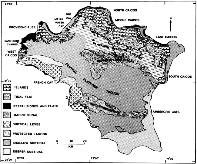
The oolitic sediment bodies of Caicos platform illustrate a different influence of preexisting topography. There, in the easterly Trade Winds, many of the oolite sediment bodies form because of protection and current flow defined by preexisting topography (fig. 8) (Wanless et al., 1989). Two oolitic grainstone banks have formed down-current from emergent islands on the windward side of Caicos platform (behind South Caicos and Ambergris Cay; fig. 8). Cross-platform current flow has streamlined these oolitic sands into elongate shoals (fig. 8, areas 1 and 3). The southerly bank (Ambrigris shoal; area 1 in fig. 8) extends across the entire platform, shedding sediment off the leeward platform margin (area 2 in fig. 8). The position of an emergent feature on the eastern side of Caicos platform defines not only the position of sediment bodies on the platform but also the focus of off-bank sediment transport on the opposite side of the platform. The northerly bank (midplatform shoal; area 3 in fig. 8) segregates a protected peloidal packstone-wacke stone lagoon to the north (area 4 in fig. 8) from the grainstones of the more open platform.
Figure 8--Physiographic map of Caicos platform, British West Indies, showing major sediment bodies. Numbers are explained in text [from Wanless et al. (1989)].
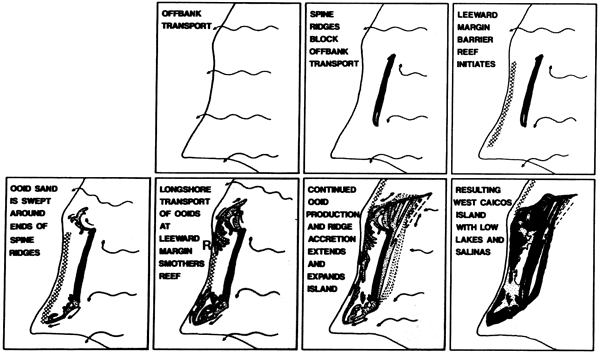
Near the northern and western margins of Caicos platform, emergent ridges of oolitic sand formed during the middle Pleistocene. Extensions to these ridges have been gradually closing off the leeward (western) margin during the late Pleistocene and Holocene (fig. 9) (Wanless et al., 1989). These ridges have permitted extensive barrier reef growth on the leeward margin during high sea-level stands by blocking the east to west transport of sediment across the bank, have initiated new sediment facies on the platform interior (e.g., the windward platform interior progradation of oolitic strand plains by production of ooids in the shore zone) (Lloyd et al., 1987), and have completely modified sedimentation in the adjacent basin by blocking and diverting cross-bank and off-bank transport (Wanless et al., 1989).
Figure 9--Gradual closing off of the leeward margin of Caicos platform by the appearance and expansion of emergent island of West Caicos and generation of reef to ooid sequences. Emergent topography of oolitic grainstone blocks off-bank transport of sediment and permits growth of a barrier reef at the leeward margin barrier reef growth (see fig. 5). Progressive expansion has occurred during several late Pleistocene interglacial highstands and the Holocene. Together with southward extension of Providenciales, a limestone island to the north, westward off-bank transport is now restricted to a narrowing channel to the north of West Caicos [from Wanless et al. (1989)].
A final example is the influence of organic deposits of mangrove peat that have formed because of the favorable influence of primary controls of sedimentation. In south Florida mangrove communities form a coastal swamp that ranges from a few hundred meters to tens of kilometers in width (Davis, 1940; Wanless, 1974; Wanless et al., 1989). The red mangrove community has produced extensive mangrove peats beneath these swamps. These peats form a major sediment body as much as 8 m (26 ft) thick and 0.1-15 km (0.06-9.3 mi) wide. This mangrove peat deposit is a significant sediment body separating the marine and freshwater deposits and environments and receives the brunt of hurricane energies. It produces acidic, tannic waters that corrode and dissolve both associated and underlying Holocene carbonate sediments and Pleistocene limestones and has deep-penetrating acidic root systems that can generate breccias in the Pleistocene limestone 2-5 m (7-16 ft) beneath the sediment surface (Wanless et al., 1989). Most important, through later oxidation and/or sulfate reduction, the mangrove peat deposit will most probably be obliterated and will not become part of the sedimentary record (Wanless et al., 1989). We are used to this concept with evaporites. It is just as important for this swamp deposit.
Interaction of primary controls on sedimentation commonly generates facies characteristics that would not be formed independently. Incorporation of two independent variables into a model may not be sufficient; their interaction may have to be defined. For example, sediment accumulation or loss rates and sediment texture are defined by the interaction of (1) rate of sediment dispersal by high-energy events and platform width, (2) potential sediment circulation by energy events and openness of platform margins, (3) rate of sediment production or supply and shallow-water bioerosion (loss of coarse particles) or dissolution (loss of fines), (4) energy potential for physical sediment transport and stabilization by vegetation or cementation, and (5) surficial sediment supply and subsurface excavation of the sequence by deep burrowers with or without storm infillings of chamber networks with sediment.
The decrease or increase in energy that permits the establishment of a sea grass (or crinoid) community is typically sufficiently minor that it would not, in and of itself, cause a significant change in bottom sedimentation or in the benthic environment. Once established on the bottom, however, sea grasses will function to significantly modify wave and current energy at the bottom (Scoffin, 1970), the stability of the bottom (Patriquin, 1975; Wanless, 1981; Wanless et al., 1989). the texture of the bottom sediments (Patriquin, 1975; Wanless, 1981; Wanless et al., 1989), the epifaunal and infaunal benthic community (Wanless, 1981), and the vertical sequences generated (Wanless, 1981; Wanless et al., 1989).
Within a setting of uniform energy, platform (or shelf) width may have a dramatic influence on sediment texture. Observations by Bagnold (1966), McCave (1971), Passega (1964), and Southard and Boguchwal (1990) suggest that we consider four dynamic populations of grain size:
>650 µm: tends to move as a true bedload
175-650 µm: mixed bedload and saltation load
40-175 µm: short-term or graded suspension load (drops out as current energy stops or detaches from bottom)
<40 µm: long-term suspension (remains in suspension for some time after currents stop or detach from bottom because of ambient turbulence in the water column)
On narrow shelf and platform margins energy events may be sufficient to move all these textural populations of sediment off the platform before final deposition. With increasing platform width, the coarsest textural group will be partly and then completely retained on the platform under the same intensity and frequency of energy events. As platform width further increases, the finer-grained populations will be partly and then completely retained on the shelf. Thus, on the interior of extremely wide platforms, such as the Cambrian cratonic margins, the fine silt and clay fractions may be nearly completely retained in the shallow-marine environment simply because the platform width is too great for effective sediment dispersal. Similar variation also could be achieved with a constant platform width and varying frequency and intensity of reworking, rate of sediment input, and presence of a seaward barrier to sediment dispersal. These factors interact to define the rate of accumulation and the texture of the deposits.
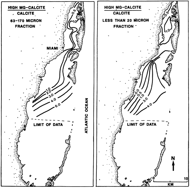
The carbonate muds of Biscayne Bay provide another example of the interacting influences of controls on sedimentation (fig. 10) [Burton (1984) and my observations]. Marine organisms in Biscayne Bay produce aragonite, high-magnesium calcite, and minor low-magnesium calcite. The sediments on the mudbanks forming the seaward boundary of Biscayne Bay contain predominantly high-magnesium calcite and aragonite. These components gradually decrease along a landward transect across the bay until only low-magnesium calcite is present in the landward 1-3 km (0.6-5 mi) (fig. 10). Although there is both biogenic production and storm dispersal of aragonite and high-magnesium calcite throughout this open bay, the inshore waters are seasonally of low salinity and tannin rich. These waters, together with decay processes in the upper part of the sediment sequence, promote selective dissolution of the less stable carbonate components. This dissolution is visible in the partly dissolved and crumbly skeletal macrofauna. Thus minor variation in the waters across Biscayne Bay is producing sediments with strikingly contrasting mineralogies, different rates of sedimentation, and different diagenetic potentials.
Figure 10--Calcite composition of the bottom sediment for two size fractions [fine-sand fraction (170-63 µm) and fine silt and clay fraction (<20 µm)] in Biscayne Bay, southeast Florida. Both show a landward decrease in high-magnesium calcite, expressed as ratio of high-magnesium calcite/calcite. Redrawn from Wanless et al. (1984).
Physical, biogenic, and chemical controls have discrete but subtle temporal and spatial boundaries to their influence. For example, winter storms, hurricanes, and other physical controls occur only over certain geographic ranges, and this range changes with geologic time. Subtle changes in water chemistry, temperature, and residence time define limits for various types of carbonate sedimentation and diagenesis (e.g., ooid production, bioerosion, intragranular and intergranular cementation).
Hurricanes and winter storms are dramatic influences on sedimentation, but both have defined spatial and temporal limits. Shallow-marine Holocene sedimentation in the Caribbean, Bahamas, or the Atlantic and Gulf coasts of the United States is strongly influenced by hurricanes (Neumann et al., 1978). The influence is present throughout these areas, although the statistical frequency and intensity spectrum vary from place to place. Shallow-marine Holocene sedimentation along the eastern coast of Brazil, however, is not influenced by hurricanes or winter cold fronts (Leao, 1982). There are large areas on the globe today where hurricane-type storms do not occur. The character of a reef sequence in Brazil (Leao, 1982) will be different from one in Bermuda, Bahamas, south Florida, and the Caribbean [e.g., Ball et al. (1967)].
Barron (1989) suggests that there were times in the Earth's history, such as the Eocene, when hurricanes were totally absent because the oceanic temperatures were not sufficient to maintain intense cyclonic circulation and perhaps other times when warm sea surface temperatures promoted more frequent and intense hurricanes than those occurring today. Barron also suggests that an absence of landmasses in polar latitudes may have limited the development of winter storm systems during certain periods (e.g., the Cretaceous). Winter storms are today a major influence on some carbonate depositional environments. The physical dynamics and sedimentary structures that characterize the channeled tidal flats on Andros Island, Bahamas, and the subtidal mudbanks in Florida Bay are largely a product of winter storm sedimentation (Ginsburg, 1956; Hardie, 1977; Enos and Perkins, 1979; Wanless and Tagett, 1989). What would be the nature of these depositional environments in the absence of winter storm and hurricane influences?
It is important to consider other high-energy-event influences in addition to or instead of local storms. Long-period swells moving across an ocean from distant storms may cause a sedimentation event on shelves, reefs, and shorelines equal to or greater than locally generated, shorter-period storm waves (Wanless et al., 1989). Similarly, tectonic activity generates intense local surges and far-reaching tsunamis.
Modeling of the nature and distribution of storm influences needs empirical verification. King (1990) recently suggested (through modeling) that the Mississippian Waulsortian carbonate mud mounds formed in a time and area where storms were absent--low latitude on the margin of the Laurussian shelf or seaway. Previously, Wright (1986) had documented (through field studies) that these ramped shelf sequences (in south Wales) were dominated by storm processes but that the Waulsortian mud mounds were positioned on the deeper outer shelf below storm wave base. It is fundamental to empirically test and calibrate models in the field or at least use the information that is provided in the literature.
Diagenetic modifications include syndepositional biogenic modifications through repetitive burrow excavations and infillings [causing transformation of an existing deposit by subsurface generation of facies with new sediment composition, texture, permeability, and diagenetic potential; loss of transgressive facies (Wanless and Tagett, 1986, 1989; Tagett, 1989); amalgamation of sedimentary cycles (Wanless and Tedesco, 1987); and replacement, transformation, or obliteration of the sediment facies that initiated or constructed a sediment body] and later stage compaction and pressure dissolution that reduces depositional thickness and modifies the fabric, mineralogy, and porosity and permeability of sequences.
The profound influence of diagenetic modifications on the nature of the sedimentary sequence is illustrated by several examples.
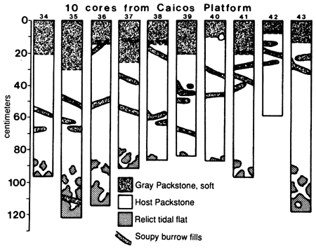
Excavating burrowers provide a dramatic example of the influence of early diagenetic modifications on both the nature of the preserved sequence and the subsequent diagenetic potential. Deep burrowers, such as Callianassa, are not mixers of the sediment; they are excavators of extensive open cavities that extend one to several meters beneath the sediment surface and may comprise as much as 10% of the sequence. Storms may produce catastrophic infilling of these open networks (fig. 11) (Wanless, Tedesco, and Tyrell, 1988). Repetitive excavation and infilling of the sequence can produce a sequence or portion of a sequence that is a new deposit produced in the subsurface by repetitive tubular tempestite infillings, completely replaces the precursor sequence, and has a depositional sediment fabric formed in the subsurface with only indirect relation to the syndepositional or precursor surficial depositional texture (Wanless, Tedesco, and Tyrell, 1988; Wanless et al., 1989; Tedesco and Wanless, 1991). Failure to recognize this will cause misinterpretation of the depositional environments and processes and misrepresentation of timing and rates of sedimentation. Repetitive deep excavation affects sedimentation rates by bringing fine sediment to the surface, providing repeated opportunities for sediment transport. Storm infilling of deep excavations with the coarser bedload material causes loss of a coarser lag that can inhibit surficial erosion during storms.
Figure 11--Distribution of new surficial and tubular tempestite deposits (gray packstone, soft) from Hurricane Kate in ten cores taken in the peloidal packstone environment approximately 1 km (0.6 mi) bankward (south) of North Caicos tidal flats, Caicos platform [star in fig. 8 (above "4")]. New tubular tempestite burrow fillings extend to 110 cm (43.3 in.) below the sediment surface and comprise 10% of the upper 75 cm (30 in.). Shell concentrations are in black. Unshaded circle is open burrow [from Wanless et al. (1989)].
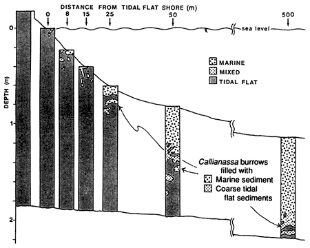
Repetitive excavation and infilling of open burrow networks can also partly to completely transform depositional cycles of sedimentation. The tidal flats on Caicos platform have deposited a 1-3-m-thick (3-9-ft-thick) sequence of tidal-flat peats and muds containing coarse cerithid gastropods. The tidal-flat shoreline facing the platform interior is gradually eroding, potentially producing a transgressive sequence. Within 0.5 km (0.3 mi) of the shoreline, however, the entire tidal-flat sequence is obliterated down to the Pleistocene limestone surface, not by physical erosion but by progressive transformation through repetitive excavation of burrow networks and subsequent storm infilling with marine sediments (fig. 12) (Wanless et al., 1989). Only scattered vestiges of the tidal-flat deposit and a concentration of the coarse tidal-flat fauna in the deeper burrow infills (where the Callianassa pack particles too coarse to expel) are testimony to the fact that this is a biogenically transformed sequence (Wanless et al., 1989). The basal coarse fauna could easily be misinterpreted as a basal transgressive lag to a marine sequence. In the absence of deep excavating burrowers, the Holocene transgression would have preserved a thick tidal-flat unit as the basal part of this cycle of sedimentation.
Figure 12--Core sequences taken bankward from the erosional south-facing tidal-flat coastline of North Caicos [see star in fig. 8 (above "4") for location]. Core sequences record progressive transformation of the transgressed tidal-flat deposit into a marine deposit by repetitive excavation and infilling of Callianassa burrow tubes and chambers. Coarse tidal-flat fauna, not expelled by excavation, is gradually worked toward the bottom of the sequence during this transformation [from Wanless et al. (1989)].
The implications of this facies transformation by burrow excavation and infilling are immense. In the Glen Rose Limestone (Lower Cretaceous), for example, fillings of Thallassinoides, an important unlined burrow excavation structure extending back to the Cambrian (Droser and Bottjer, 1988; Kepper, 1981), have generated or transformed significant portions of the sequence (Wanless and Tedesco, 1987). The Glen Rose contains numerous meter-scale, shallowing-upward sequences. In many of these, excavation and infilling have transformed the basal transgressive portion of the cycle. If the regressive (peritidal) cycle cap is not hardened by subaerial exposure or marine cementation, burrowers of the next cycle of sedimentation partly to completely obliterate the cycle boundary, causing local amalgamation of cycles.
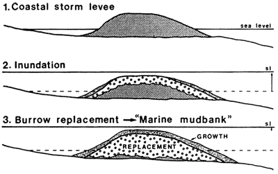
In the Holocene of Florida Bay, peritidal coastal mangrove peats and storm levee marls provide the initiation for many of the subtidal mudbanks [see last example (preexisting topography) on p. 471 (Wanless and Tagett, 1989). As sediment bodies, many of the mudbanks are simply transgressed coastal levees and mangrove peninsulas (Cottrell, 1989). In the inner parts of Florida Bay this transgression is commonly well preserved in bank stratigraphy because fluctuating salinity conditions inhibit a deep burrowing fauna. In central and outer Florida Bay, however, deep excavating burrowers are present and have transformed these transgressed coastal peat and marl deposits into marine mudbanks (Tagett, 1989) (fig. 13). That is, some mudbanks are sediment bodies generated as coastal peat-levee deposits but were subsequently transformed into marine mudbanks! Where completely transformed, the only evidence of precursor facies is the coarse skeletal concentrates of freshwater, paralic, and brackish fauna in lower burrow infills (Tagett, 1989; Wanless and Tagett, 1989). The origin of significant sediment bodies can be obscure.
Figure 13--Sequence of schematic cross sections of a coastal levee at the northern margin of Florida Bay as it becomes inundated by rising sea level and is gradually transformed into a marine mudbank by repetitive excavation and infilling of burrow complexes. As in fig. 12, the only evidence that this sediment body originated as a coastal levee buildup might be an anomalous coarse fauna concentrated at the base of the sequence.
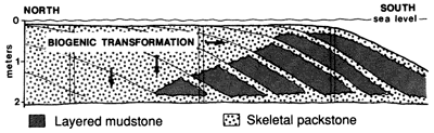
Similarly, many of the modern carbonate mudbanks build and expand by event deposition-layered mudstones in the banks of the coastal lagoons and packstone to grainstone tempestite units in the more exposed banks. As the banks build to sea level, the rate of vertical accretion of the bank interior (bank core) slows, and the underlying sequence can be partly to completely transformed by burrow excavation and storm infilling. Layered mudstones, packstones, and grainstones are commonly transformed into bioturbated skeletal packstones by repetitive burrow excavation and infill (fig. 14) (Tedesco and Wanless,1991; Wanless and Tagett, 1989). Such transformations also determine the sediment texture, fabric, and composition during the gradual vertical accretion of the core facies of modern (and ancient) mudbanks.
Figure 14--Biogenic transformation across a prograding carbonate mudbank in Florida Bay. Bank growth is primarily by deposition of layered mudstone units (some with an erosional base and a coarser lower part and/or stabilization by sea grass before deposition of the next layered mudstone). The sequence undergoes progressive biogenic transformation, forming a skeletal wackestone or packstone by repetitive excavation and infilling of deep, open burrow complexes and resulting in the complex facies patterns.
The New Market Limestone (Ordovician) of western Maryland contains striking carbonate cycles of sedimentation (Reinhardt and Hardie, 1976; Wanless, 1986). Figure 15 shows one measured cycle of sedimentation recorded from bottom to top as underlying supratidal dolomitic deposits (p); a deepening peritidal to shallow subtidal sequence of high-relief stromatolite heads with planar millimeter-thick laminae to high-relief pustular stromatolites (thrombolites) to microthickets of tiny corals (Lichenaria, Fletcheria, and Prismostylus; Neuman, 1951) in a thinly interbedded limestone and dolomite with burrow structures, gastropods, and other skeletal grains (A → B → C); a "deep" sequence of interbedded limestone and dolomite that contains no macrofauna and no trace fossils (D); a shallower subtidal sequence of interbedded limestone and dolomite in which gastropods, other skeletal grains, and burrowers reappear (E); a shallowing subtidal to peritidal sequence of thinly interbedded limestone and dolomite with microthickets of the corals to low-relief pustular stromatolites (thrombolites) to low-relief stromatolite sheets with millimeter laminae to desiccation cracks in low relief stromatolite sheets with millimeter-thick laminae (F → G → H); and increasingly dolomitic supratidal deposits (I and J). Note that the form of the stromatolites is high relief during the deepening (transgressive A → B) phase and low relief during the shallowing (regressive G → H) phase (Wanless, 1986).
Figure 15--Characteristics of one typical fundamental depositional sequence in the Ordovician New Market Limestone, western Maryland [in pasture 0. 5 mi (0. 8 km) southwest of St. Paul's Church, US-40, Washington County]. The left-hand side is measured section and distribution of pertinent characteristics. Units A to J are described in the text. The right-hand side is the uncompacted sequence obtained by expanding the section for the minimum observed thinning by pressure dissolution. Minimum water depths are indicated by the solid and dashed lines adjacent to the measured and uncompacted sections [diagram expanded from Wanless (1986)].
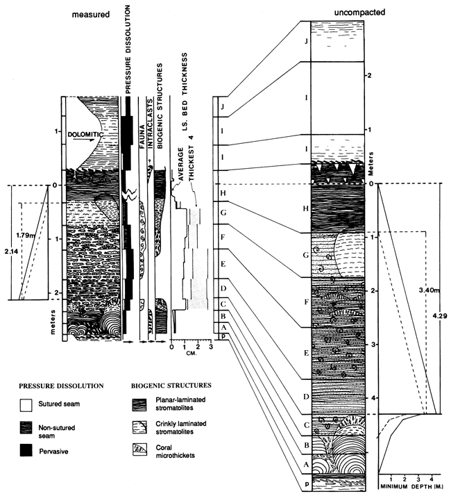
The described sequence forms an essentially symmetric cycle with the abiotic interbedded limestone and dolomite zone (D) representing the deepest portion of the cycle. This unit presumably represents a time of anoxic bottom waters because of the lack of macrofauna and lack of burrowers. The gastropods in the overlying units reflect the reappearance of algae as a bottom food source, and the burrowers reflect oxygenated bottom waters.
The vertical distance from the deepest portion of the cycle (D) to the overlying stromatolites with millimeter-thick laminae (base of H) is 1.8 m (5.9 ft); to the first desiccation cracks (middle of H) is 2.1 m (6.9 ft). If this represents the valid thickness of sediment accumulation from the deepest subtidal anoxic sedimentation to the supratidal, a fluctuation of sea level would seem necessary to generate this cyclic sequence. Anoxic bottom environments are not at all common in modern carbonate environments at depths of 1.8-2.1 m (5.9-6.9 ft). There are, however two critical flaws with this reasoning.
First, in evaluating cyclic sequences, it is critical to determine the decrease in thickness that has occurred because of later diagenesis, especially pressure dissolution. In the described cycle, a bed-by-bed examination was made to determine the minimum pressure dissolution that has occurred by sutured seam dissolution, nonsutured seam dissolution (microstylolites), and pervasive dissolution and dolomitization (Wanless, 1979). Thinning associated with larger sutured seams were defined by height in outcrop; thinning because of smaller seams, nonsutured seams, and pervasive dissolution thinning was assessed in thin section and by outcrop measurements of bed pinching. The result is that the sequence has thinned by at least 50% because of pressure dissolution (see fig. 15). Thus the sequence from "deepest" to peritidal was at least 3.4-4.3 m (11-14 ft). Anaerobic conditions occur in a number of modern coastal lagoons, bays, and estuaries at these water depths (Rossinsky, 1984; Wanless et al., 1984). Thus, by correcting for thickness reduction by subsequent pressure dissolution, other mechanisms for cycle generation become available for consideration. Sea-level fluctuations are not required to produce the observed cycles from the point of view of thickness of cycles.
Second, during and just after times of transgression and rising sea level, large volumes of nutrients can be expected to be released from coastal freshwater, paralic, and marine swamps, marshes, tidal flats, and upland soils (Hallock and Schlager, 1986). This may provide a phase of high nutrient stress to the coastal lagoons, bays, and estuaries. Thus, during and just after transgression, anoxia might form in shallower bays than would be the case during times of sea-level stability and regression. Study of modern environments, however, would not pick up this character because sea level has been stable to only gradually rising for the last 3,000 years (Wanless, 1981) and the protected coastal and adjacent freshwater environments mostly have not been transgressive (Wanless et al., 1989). Nutrient excess, even if not producing anoxia, is a well-recognized stress on carbonate production and even on the survival of carbonate platforms (Hallock and Schlager, 1986).
One must be careful in applying influences, patterns, and rates from one scale of sedimentation to another. Many fundamental controls on sedimentation have different effects on different scales of sedimentary cycles. The finer scales of sedimentation may not be conducive to predictive modeling, especially if the driving forces are episodic.
Holocene analogues represent sedimentary cycles in various stages of completeness. Integration with Pleistocene sequences are a first step toward assessing the duration necessary for generating complete fundamental depositional sequences and assessing usefulness of the Quaternary as analogues to times of dampened eustatic driving forces.
Most modeling efforts attempt to incorporate those influences that the modeler recognizes as important. It is hoped that this article has increased the modeler's awareness of influences on sedimentation, shown the importance of defining and working from the fundamental depositional sequence, demonstrated the need for field calibration and testing of models, and imposed caution in modeling similarly different scales of sedimentary cycles.
It is geologic observation at the scale of the fundamental depositional sequence that must be understood and used to properly design and implement useful models of sequence development. For example, the diagenetic processes affecting a reservoir facies may be strongly controlled by the continuity and form of facies (whether or not portions of an individual fundamental depositional sequence reached emergence), the pattern of marine diagenesis (cementation, dissolution, burrow transformation), and the textural and compositional sequence of the fundamental depositional sequence. At the scale of the fundamental depositional sequence the spectrum of depositional influences must be carefully considered. Fundamental depositional sequences commonly group into larger-scale sequences or cycles.
A model is heavily biased by the modeler's sphere of experience. One not familiar with the potential of nutrients will probably tend to downplay their importance. It is important that the spectrum of potential influences be carefully assessed for each modeling situation. This generally means that modeling cannot be a canned black box but needs an interdisciplinary group of scientists to weigh the influences of each modeling effort.
What the field sedimentologist must provide is accurate documentation of what influences sedimentation, the sedimentologic criteria to distinguish the various mechanisms, and an understanding of where and to what degree each mechanism should be expressed in the stratigraphic record.
The topics covered are the result of interactive research with many students and colleagues. Sections in the Ordovician of western Maryland were measured with T. Aigner. I acknowledge D. Cottrell, M. Tagett, L. Tedesco, and R. Warzeski (research on carbonate mudbanks), E. Barron, R. Parkinson, M. Perlmutter, and J. Rine (texture and storm sedimentation), E. Burton (sediment composition and dynamics), J. Dominguez (strand plains and sea level), R. Parkinson (sea level), J. Dravis and G. Grabowski (Caicos tidal flats), and M. Tagett and L. Tedesco (burrow fabric generation). Research was supported by the National Science Foundation under grant EAR-77-13707 (for Florida Bay), grant OCE-86-04449 (for hurricane effects on Caicos Platform), and grant EAR-89-17315 (for effects of burrow excavation and infilling). Facies studies on Caicos platform were conducted with grants from ARCO, Exxon Production Research Corp., and UNOCAL. Reviewers P. Enos, S. Schutter, and W. Ross provided major improvements to the manuscript, and their enthusiasm for this topic is greatly appreciated. I have included some examples and logic suggested by them. Most valuable is the recognition by W. Lynn Watney and Evan Franseen that modeling sedimentary sequences begins with lithologic calibration.
Aigner, T., and Reineck, H. E., 1982, Proximality trends in modern storm sands from the Helgoland Bight (North Sea) and their implications for basin analysis: Senckenbergiana Maritima, v. 14,p.183-215
Aitken, J. D., 1966, Middle Cambrian to Middle Ordovician cyclic sedimentation, southern Rocky Mountains of Alberta: Canadian Petroleum Geologists, Bulletin, v. 14, p. 405-441
Alderson, E. J., and Goodwin, P. W., 1978, Punctuated aggradational cycles (PACs) in Middle Ordovician and Lower Devonian sequences: Proceedings of the 50th Annual Meeting, New York State Geological Society, v. 50, p. 204-224
Bagnold, R. A., 1966, An approach to the sediment transport problem from general physics: U.S. Geological Survey, Professional Paper 422-I, 32 p.
Ball, M. M., Shinn, E. A., and Stockman, K. W., 1967, The geologic effects of hurricane Donna in south Florida: Journal of Geology, v.75,p.583-597
Barron, E. J., 1989, Severe storms during Earth history: Geological Society of America, Bulletin, v. 101, p. 601-612
Bruun, P., 1962, Sea level rise as a cause of shore erosion: Journal of Waterways and Harbors, v. 88, p. 117-130
Burton, E. A., 1984, X-ray diffraction of natural high and low Mg calcites: M.S. thesis, University of Miami, Coral Gables, Florida, 148 p.
Coleman, J. M., and Wright, L. C., 1975. modern river deltas--variability of process and sand bodies; in, Deltas--Models for Exploration, Broussard, M. L., ed.: Houston Geological Society, p.99-150
Cottrell, D. J., 1989, Holocene evolution of the coast and nearshore islands, northeast Florida Bay, Florida: Ph.D. dissertation, University of Miami, Coral Gables, Florida, 194 p.
Davies, T. D., 1980, Peat formation in Florida Bay and its significance in interpreting the recent vegetational and geological history of the bay area: Ph.D. dissertation, Pennsylvania State University, University Park, 306 p.
Davis, J. H., Jr., 1940, The ecology and geologic role of mangroves in Florida: Carnegie Institute, Publication 517, Papers from Tortugas Laboratory, v. 32, p. 303-412
Dominguez, J. M. L., 1987, Quaternary sea-level changes and the depositional architecture of beach-ridge strand plains along the east coast of Brazil: Ph.D. dissertation, University of Miami, Coral Gables, Florida, 288 p.
Dominguez, J. M. L., Martin, L., and Bittencourt, A. C. S. P., 1987, Sea-level history and Quaternary evolution of river mouth-associated beach-ridge plains along the east-southeast Brazilian coast--a summary; in, Sea-Level Fluctuation and Coastal Evolution, Nummedal, D., Pilkey, O. H., and Howard, J. D., eds.: Society of Economic Paleontologists and Mineralogists, Special Publication 4 1, p. 115-127
Droser, M. L., and Bottjer, D. J., 1988, Trends in depth and extent of bioturbation in Cambrian marine environments, western United States: Geology, v. 6, p. 233-236
Enos, P., and Perkins, R. D., 1979, Evolution of Florida Bay from island stratigraphy: Geological Society of America, Bulletin, v. 90,p.59-83
Ginsburg, R. N., 1956, Environmental relationships of grain size and constituent particles in some south Florida carbonate sediments: American Association of Petroleum Geologists, Bulletin, v. 40, p. 2,384-2,427
Hallock, P., and Schlager, W., 1986, Nutrient excess and the demise of coral reefs and carbonate platforms: Palaios, v. 1, p. 389-398
Hardie, L. A., 1977, Sedimentation on the modern carbonate tidal flats of northwest Andros Island, Bahamas: Studies in Geology 22, Johns Hopkins University Press, Baltimore, Maryland, 202 p.
Heckel, P. H., 1978, Field trip no. 2; in, Field Guide to Upper Pennsylvanian Cyclothemic Limestone Facies in Eastern Kansas: Kansas Geological Survey, Guidebook Series 2, 79 p. [available online]
Heckel, P. H., 1983, Diagenetic model for carbonate rocks in midcontinent Pennsylvanian eustatic cyclothems: Journal of Sedimentary Petrology, v. 53, p. 733-759
Hunter, R. E., 1989, Eolianites in the Ste. Genevieve Limestone of southern Indiana; in, Geometry and Depositional Environments of Ste. Genevieve (Mississippian) Oolite Bodies in Southern Indiana, Carr, D. D., and Hunter, R. E.: Indiana Geological Survey Guidebook, Bloomington, 19 p.
James, N. P., 1984, Introduction to carbonate facies models; in, Facies Models, Walker, R. G., ed.: 2d ed., Geoscience Canada Reprint Series 1, Geological Association of Canada, p. 209-211
Kepper, J. C., 1981, Sedimentology of a Middle Cambrian outer shelf margin with evidence for syndepositional faulting, eastern California and western Nevada: Journal of Sedimentary Petrology, v. 51, p.807-821
King, D. T., Jr., 1990, Early Carboniferous global paleogeography and the distribution of Waulsortian and Waulsortian-like carbonate mud mounds: Abstracts of Papers, 13th International Sedimentological Congress, Nottingham, England, p. 273-274
Leao, Z. M. de A. N., 1982, Morphology, geology, and developmental history of the southernmost coral reefs: Ph.D. dissertation, University of Miami, Coral Gables, Florida, 216 p.
Lloyd, R. M., Perkins, R. D., and Kerr, S. D., 1987, Beach and shoreface ooid deposition on shallow interior banks, Turks and Caicos Islands, British West Indies: Journal of Sedimentary Petrology, v. 57, p. 976-982
McCave, I. N., 1971, Sand waves in the North Sea off the coast of Holland: Marine Geology, v. 10, p. 199-225
McKee, E. D., 1945, Cambrian history of the Grand Canyon region--pt. 1, stratigraphy and ecology of the Grand Canyon Cambrian: Carnegie Institute Publication 563, 168 p.
Merriam, D. F., ed., 1964, Symposium on cyclic sedimentation: Kansas Geological Survey, Bulletin 169 (2 v.), 636 p. [available online]
Neuman, R. B., 1951, St. Paul Group--a revision of the "Stones River" Group of Maryland and adjacent states: Geological Society of America, Bulletin, v. 62, p. 267-324
Neumann, C. J., Cry, G. W., Caso, E. L., and Jarvinen, B. R., 1978, Tropical cyclones of the North Atlantic Ocean, 1871-1977: National Climatic Center, Ashville, North Carolina, Government Printing Office, 170 p.
Passega, R., 1964, Grain size representation by CM patterns as a geological tool: Journal of Sedimentary Petrology, v. 34, p. 830847
Patriquin, D. G., 1975, "Migration" of blowouts in seagrass beds at Barbados and Carriacou, West Indies, and its ecological and geological implications: Aquatic Botany, v. 1, p. 163-189
Perkins, R. D., 1986, The default concept in carbonate sedimentation (abs.): Society of Economic Paleontologists and Mineralogists, Annual Meeting, Abstracts, v. 3, p. 88
Reinhardt, J., and Hardie, L. A., 1976, Selected examples of carbonate sedimentation, lower Paleozoic of Maryland: Maryland Geological Survey, Guidebook 5, 53 p.
Rossinsky, V., Jr., 1984, Sedimentation and Holocene history of the Loxahatchee River Estuary, Jupiter, Florida: M.S. thesis, University of Miami, Coral Gables, Florida, 242 p.
Schwartz, M. L., 1967, The Bruun theory of sea-level rise as a cause of shore erosion: Journal of Geology, v. 75, p. 76-91
Scoffin, T. P., 1970, Trapping and binding of subtidal carbonate sediments by marine vegetation in Bimini Lagoon, Bahamas: Journal of Sedimentary Petrology, v. 40, p. 249-273
Southard, J. B., and Boguchwal, L. A., 1990, Bed configuration in steady unidirectional water flows--pt. 2, synthesis of flume data: Journal of Sedimentary Petrology, v. 60, p. 658-679
Swift, D. J. P., 1968, Coastal erosion and transgressive stratigraphy: Journal of Geology, v. 76, p. 444-456
Tagett, M. G., 1989, Stratigraphy, nucleation, and dynamic growth history of a Holocene mudbank complex, Dildo Key mudbank, western Florida Bay: M.S. thesis, University of Miami, Coral Gables, Florida, 210 p.
Tedesco, L. P., and Wanless, H. R., 1991, Generation of sedimentary fabrics and facies by repetitive excavation and storm infilling of burrow networks: Palaios (in press)
Vail, P. R., Mitchum, R. M., Jr., and Thompson, S., III, 1977, Seismic stratigraphy and global changes of sea level--pt. 3, relative changes in sea level from coastal onlap; in, Seismic Stratigraphy--Applications to Hydrocarbon Exploration, Payton, C. E., ed.: American Association of Petroleum Geologists, Memoir 26, p. 63-81
Walker, R. G., and Harms, J. C., 1971, The "Catskill delta"--a prograding muddy shoreline in central Pennsylvania: Journal of Geology, v. 79, p. 381-399
Wanless, H. R., 1969, Sedimentary structures and zonation on tidal levees, Andros Island, Bahamas (abs.): American Association of Petroleum Geologists Bulletin, v. 53, p. 748
Wanless, H. R., 1973a, Cambrian of the Grand Canyon--a reevaluation (abs.): American Association of Petroleum Geologists Bulletin, v. 57, p. 810-811
Wanless, H. R., 1973b, Cambrian of the Grand Canyon--a reevaluation of the depositional environment: Ph.D. dissertation, Johns Hopkins University, Baltimore, Maryland, 115 p.
Wanless, H. R., 1974, Mangrove sedimentation in geologic perspective; in, Environments of South Florida, Present and Past, Gleason, P. J., ed.: Miami Geological Society, Memoir 2, p. 190200
Wanless, H. R., 1979, Limestone response to stress-pressure solution and dolomitization: Journal of Sedimentary Petrology, v. 49, p. 437-462
Wanless, H. R., 1981 , Fining-upward sedimentary sequences generated in seagrass beds: Journal of Sedimentary Petrology, v. 5 1, p. 445-454
Wanless, H. R., 1986, Transgressive and regressive stromatolites (abs.): Society of Economic Paleontologists and Mineralogists, Annual Meeting, Abstracts, v. 3, p. 114
Wanless, H. R., and Tagett, M. G., 1986, Burrow-generated false facies and phantom sequences: American Association of Petroleum Geologists, Bulletin, v. 70, p. 660
Wanless, H. R., and Tagett, M. G., 1989. Origin, growth, and evolution of carbonate mudbanks in Florida Bay: Bulletin of Marine Science, v. 44, p. 454-489
Wanless, H. R., and Tedesco, L. P., 1987, Burrow-generated sedimentary sequences--an example from the Glen Rose Formation, Lower Cretaceous, Austin, TX (abs.): Society of Economic Paleontologists and Mineralogists, Annual Meeting, Abstracts, v. 4, p. 88-89
Wanless, H. R., Rossinsky, V., Jr., and McPherson, B. F., 1984, Sedimentologic history of the Loxahatchee River Estuary, Florida: U.S. Geological Survey, Water-Resources Investigations Report 84-4120, 58 p. [available online]
Wanless, H. R., Tedesco, L. P., and Tyrrell, K. M., 1988, Production of subtidal tubular and surficial tempestites by Hurricane Kate, Caicos platform, British West Indies: Journal of Sedimentary Petrology, v. 58, p. 739-750
Wanless, H. R., Cottrell, D., Parkinson, R., and Burton, E., 1984, Sources and circulation of turbidity, Biscayne Bay, Florida: Final Report to Dade County and Florida Sea Grant, 499 p.
Wanless, H. R., Tedesco, L. P., Rossinsky, V., Jr., and Dravis, J. J., 1989, Carbonate environments and sequences of Caicos platform with an introductory evaluation of south Florida: Field Trip Guidebook T374, American Geophysical Union, Washington, D.C., 75 p.
Wanless, H. R., Tyrrell, K. M., Tedesco, L. P., and Dravis, J. J., 1988, Tidal flat sedimentation from Hurricane Kate, Caicos Platform, BWI: Journal of Sedimentary Petrology, v. 58, p. 724738
Wilson, J. L., 1975. Carbonate facies in geologic history: Springer-Verlag, New York, 471 p.
Wright, L. D., and Coleman, J. M., 1973, Variations in morphology of major river deltas as functions of ocean wave and river discharge regimes: American Association of Petroleum Geologists, Bulletin, v. 57, p. 370-398
Wright, V. P., 1986, Facies sequences on a carbonate ramp--the Carboniferous limestone of south Wales: Sedimentology, v. 33, p. 221-241
Zeller, E. J., 1964, Cycles and psychology; in, Symposium on Cyclic Sedimentation, Merriam, D. F., ed.: Kansas Geological Survey, Bulletin 169, v. 2, p. 631-636 [available online]
Kansas Geological Survey
Comments to webadmin@kgs.ku.edu
Web version March 12, 2010. Original publication date 1991.
URL=http://www.kgs.ku.edu/Publications/Bulletins/233/Wanless/index.html