| Original published in D. W. Steeples, ed., 1989, Geophysics in Kansas: Kansas Geological Survey, Bulletin 226, pp. 165-176 | ||
1University of Kansas, 2Tenneco Oil Company, and 3Cornell University
The article is also available as an Acrobat PDF file.
COCORP deep seismic-reflection profiles in northeastern Kansas reveal a structurally complex Proterozoic crust, in which most prominent is the central basin and related features of the Keweenawan rift. The 40-km (24-mi)-wide rift basin is asymmetric, reaching a maximum depth of 8 km (5 mi) on its western side. The basin fill is characterized by a lower, layered sequence of strong west-dipping reflectors which may correlate with middle Keweenawan interbedded volcanic and clastic rocks exposed in the Lake Superior region. Overlying this layered sequence is a zone of weak, discontinuous reflectors correlated here with the predominantly clastic rocks which characterize the upper Keweenawan sequence near Lake Superior. The reflection character of the seismic data, the seismic-velocity distribution, and gravity modeling suggest that mafic intrusions lie beneath the main rift basin. Normal faults associated with the rift dip at moderate angles to the east. Palinspastic reconstruction indicates that the rift basin formed by the rotation of fault-bounded blocks during crustal extension. Relative to the area of the Keweenawan rift, the older 1.6-b.y.-old crust flanking the rift contains few prominent reflectors at depths less than 10 km (6 mi). However, those reflectors which are present, particularly in the area of the late Paleozoic Humboldt fault zone and the 1.3-b.y.-old Big Springs aeromagnetic anomaly, dip to the east, subparallel to the faults in the 1.1-b.y.-old rift basin. Thus, the east-dipping features appear to have been active during more than one episode of crustal deformation.
Between 1979 and 1981, the Consortium for Continental Reflection Profiling (COCORP) collected 317 km (190 mi) of deep seismic-reflection data in northeastern Kansas (fig. 1). These seismic data provide information on the mid-Proterozoic basement rocks of Kansas (Brown et al., 1983), the evolution and structure of the late Proterozoic Keweenawan rift (Serpa et al., 1984), and suggest that older basement structures influenced the Phanerozoic evolution of northeastern Kansas.
Figure 1--Structural contours (in thousands of feet) at the top of the Precambrian basement in northeastern Kansas (after Cole, 1976) showing the location of COCORP profiles. Numbers refer to the VP locations on the surface. Dark shading shows the inferred extent of the mafic rocks of the Keweenawan rift and dots represent the arkosic rocks of the Keweenawan (Bickford et al., 1979). Light shading marks the trend of the Big Springs aeromagnetic anomaly (Yarger, 1981; reproduced from Serpa et al., 1984).
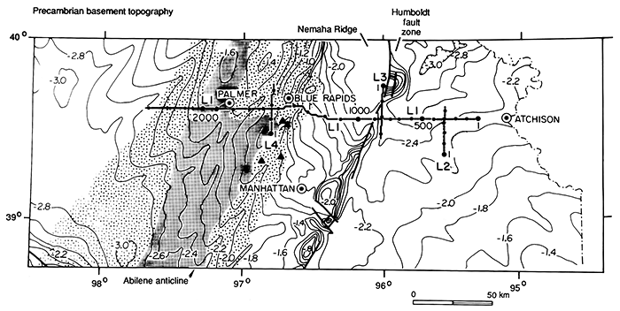
Crystalline basement rocks are not exposed in the area of the COCORP profiles because the region is covered by a thin veneer of predominately Paleozoic shallow marine sedimentary rocks (Merriam, 1963). However, the top of the Precambrian basement has been mapped from shallow well data (Bickford et al., 1979, 1981; Cole, 1976) and geophysical data (Steeples, 1976, 1982; Woollard, 1958; Yarger, 1981). This mapping indicates that the major east-west COCORP profile (line 1, figs. 1 and 2) crosses three major features in the shallow crystalline basement of Kansas. The most notable of these is the 1.1-b.y.-old Keweenawan rift, which is the source of the Midcontinent Geophysical Anomaly (MGA). The MGA consists of a linear trend of high gravity and aeromagnetic anomalies that can be traced from the area of Lake Superior (Thiel, 1956) into central Kansas and possibly as far south as southern Oklahoma (Yarger, 1981).
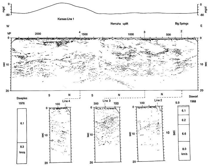
Figure 2--Line drawing of COCORP line 1 in northeastern Kansas. Gravity profile from Woollard (1958; reproduced from Serpa et al., 1984).
The late Paleozoic Nemaha Ridge is located to the east of the Keweenawan rift. The Nemaha Ridge is an approximately 40-km (24-mi)-wide basement uplift which extends to within 200 m (660 ft) of the surface on its eastern side (fig. 1). The eastern boundary of the Nemaha Ridge is the Humboldt fault zone, which appears to be nearly vertical in the shallow sedimentary rocks near the surface (Steeples, 1982).
Approximately 40 km (24 mi) east of the Humboldt fault zone are a series of circular aeromagnetic highs (Yarger, 1981), which are collectively referred to here as the Big Springs aeromagnetic anomaly. Drilling into the southern part of the anomaly indicates that the aeromagnetic highs are associated with 1.35 to 1.38-b.y.-old epizonal granites which intrude the 1.6-b.y.-old mesozonal granites of the northern Kansas basement (Steeples and Bickford, 1981). These epizonal granitic rocks appear to be related to the basement rocks in southern Kansas and, thus, may have been emplaced during the formation of the younger continental crust to the south of the study area (Bickford et al., 1981).
These three basement features are. subparallel, trending approximately north-south in the survey area (fig. 1). This trend is nearly perpendicular to the trend of other major Precambrian boundaries in the region, such as the suture between the 1.6-b.y.-old northern Kansas basement terrane and the 1.3-b.y.-old southern terrane (Bickford et al., 1981 ). The COCORP profiles indicate similarities in the orientation of structures associated with these three major features, which may be interpreted as evidence that the formation of the Humboldt fault zone and possibly the Keweenawan rift faults were controlled to some extent by structural trends which developed at least 1.35 b.y.B.P.
Approximately the first kilometer of the upper crust in the survey area consists of Phanerozoic layered sedimentary rocks. These sedimentary layers appear in the upper 0.6 sec of the seismic profiles (figs. 2 and 3) as three to five cycles of subhorizontal reflections, which are truncated at the Humboldt fault zone and seem to be absent over the Nemaha Ridge. The sedimentary rocks are present but unusually thin (approximately 200 m [660 ft] thick) in the area of the Nemaha Ridge because the late Paleozoic uplift of the crystalline basement exposed the overlying sedimentary rocks to erosion.
Wells that penetrate beneath the sedimentary cover outside of the area of the MGA commonly encounter approximately 1.6-b.y.-old granites with isolated occurrences of metasedimentary and metavolcanic rocks (Bickford et al., 1981). The subsurface extent of these granites may be indicated in the seismic data by an approximately 9-15-km (5-9-mi)-thick zone of relatively few reflectors recorded in the upper 3-5 sec of the seismic profiles (figs. 2 and 3). The only strong reflectors observed in the upper part of the crust seem to be related to the Keweenawan rift. Weak reflectors are present in the areas of the Nemaha Ridge and Big Springs aeromagnetic anomaly. These upper crustal features are discussed in subsequent sections of this paper.
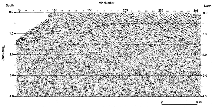
Figure 3--COCORP line 3 showing the general characteristics of the seismic data in northeastern Kansas. See fig. 1 for location of data.
This transparent upper crust is underlain at a midcrustal depth of between 9 and 15 km (5-9 mi; 3-5 sec) by a series of features which give rise to numerous strong, discontinuous reflections and diffractions in the seismic data (figs. 2 and 3). None of these midcrustal events can be traced to drillable depths and thus their source is uncertain. Three possible interpretations for these events, suggested by Brown et al. (1983), are 1) gneissic banding, 2) interlayering of granites and mafic rocks related to anatexis, and 3) the tops of diapiric mafic intrusions in the lower crust.
The strong midcrustal reflections become weaker and less continuous with increasing travel time in the crust and die out rapidly between 12 and 15 sec (36-45 km [22-27 mi]) in the seismic profiles. Refraction studies in northwestern Missouri (Stewart, 1968) and northwestern Kansas (Steeples, 1976) suggest that the base of the crust is at a depth of approximately 40 km (24 mi) in this region. Thus the loss of coherent reflections between 12 and 15 sec may be related to a transition zone between the lower crust and upper mantle (Serpa et al., 1984).
No strong reflections in the COCORP profiles can be clearly identified with the Mohorovicic discontinuity in Kansas and there appear to be only a few reflectors that have travel times consistent with their location in the upper mantle. The deep features of the crust and upper mantle are described in detail by Brown et al. (1983) and Serpa et al. (1984). The remainder of this paper addresses the shallow basement structure where well control provides some constraints on the nature of the subsurface features imaged in the COCORP seismic data.
One of the most prominent features on COCORP line 1 is the 40-km (24-mi)-wide wedge of reflectors between vibrator points (VP's) 1550 and 1950 (fig. 1). Based on the location of these events directly beneath the 70-mgal gravity high of the MGA, nearby well data (Cole, 1976; Bickford et al., 1979), and the mapped stratigraphy of rocks associated with the MGA near Lake Superior (Halls, 1966), these reflectors are interpreted as a sequence of volcanic and clastic rocks (fig. 4) deposited during the formation of the Keweenawan rift approximately 1.1 b.y.B.P. These depositional reflectors are truncated on the east and west by east-dipping reflectors which are interpreted as fault-plane reflections. Other east-dipping events are observed beneath the inferred rift-basin deposits and to the west of the main rift basin. On the basis of a palinspastic reconstruction of the apparent pre-rift configuration (fig. 5), these east-dipping events are also interpreted to be normal faults related to the Keweenawan rifting.
Figure 4--Migrated seismic data from line 1 in the area of the MGA. The upper section shows the interpretation and the lower section is unmarked (reproduced from Serpa et al., 1984).
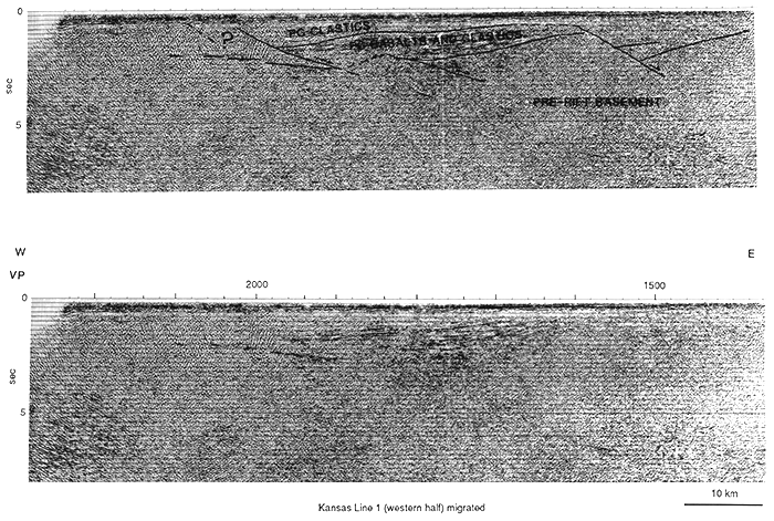
Figure 5--Geologic model for the present rift structure (bottom) and the interpreted evolutionary history during the opening of the rift basin determined by palinspastic reconstruction (reproduced from Serpa et a!., 1984).
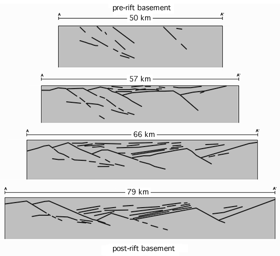
Gravity modeling of the inferred volcanic rocks within the basin does not produce a gravity anomaly that is of sufficient size to explain the 70-mgal gravity high of the MGA. Thus, the main source of the high anomaly appears to lie beneath the basin. Lateral variations in the seismic velocities measured during the processing of the COCORP data in the area of the MGA and changes in the seismic character of lower crustal reflections are consistent with the interpretation of a zone of mafic igneous rocks in the deep crust beneath the rift basin. The interpretation of mafic igneous rocks beneath the basin is similar to the model proposed for the northern part of the Keweenawan rift by Ocola and Meyer (1973).
Many features of the Keweenawan rift in Kansas, such as the apparent change in the nature of the basin fill from interlayered clastic and volcanic rocks in the lower part of the basin to predominantly clastic rocks in the upper part of the basin and the interpretation of mafic intrusions deep in the crust, are similar to features mapped or interpreted for the Keweenawan rift in the vicinity of Lake Superior (e.g., Halls, 1966; Van Schmus and Hinze, 1985) and, possibly, beneath the sediments of the Michigan basin (Zhu and Brown, 1986; Brown et al., 1982). Thus some of those features imaged in the Kansas seismic data may be characteristic of the entire Keweenawan rift (Serpa et al., 1984).
The area between VP's 910 and 1350 on profile 1 (figs. 1 and 2) covers the subsurface extent of the late Paleozoic Nemaha uplift. The COCORP seismic line crosses the eastern boundary of the Nemaha Ridge near VP 900 (fig. 1). The upwarp and general disruption of the otherwise flat, layered reflections from the Phanerozoic sediments (fig. 6) clearly indicates that the Humboldt fault zone (i.e. the eastern boundary of the uplift) is located between VP's 900 and 910.
Figure 6--Section of COCORP profile 1 in the vicinity of the Humboldt fault zone. Arrows indicate possible reflections in the crystalline basement area.
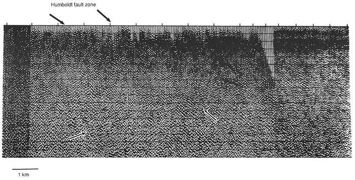
It has long been recognized that the eastern border of the Nemaha Ridge is sharply faulted. The Humboldt fault zone appears to dip at a relatively high angle where it offsets the sedimentary rocks (e.g., Steeples et al., 1979), but its deeper geometry has never been clearly defined. Because several historical earthquakes have occurred in the vicinity of the Humboldt fault zone, the nature of that structure is of regional interest. Thus, one of us, T. Setzer, conducted a detailed study of that part of the seismic data where the Humboldt fault zone is located. The following is a summary of that unpublished work.
Several weak, east-dipping reflections (15-30°) are observed on the migrated seismic section in the vicinity of the Nemaha Ridge and Humboldt fault zone (fig. 6). Because some of these reflections project toward the eastern edge of the Nemaha uplift, as defined by the disrupted sedimentary section, they are inferred to be the most probable seismic image of the Humboldt fault zone. The possibility that the steeply dipping faults in the Phanerozoic sediments continue with their near-vertical orientation into the basement appears to be eliminated by the presence of a west-dipping reflector (between 2 and 3 sec of two-way travel time) directly beneath the shallow location of the fault zone (fig. 6). Similarly a west-dipping fault zone seems to be unlikely because there are no suitably oriented reflectors, and west-dipping reverse faults would be inconsistent with the sense of drag indicated by the upwarp of the sedimentary section.
The inferred geometry of the Humboldt fault zone (i.e. moderately east-dipping with the hanging wall down) indicates that in the area of the seismic profiles the Humboldt fault zone is extensional. Well data (Cole, 1976) indicate that the surface of the Nemaha Ridge tilts to the west in a manner similar to the faulted basement blocks in the older Keweenawan rift basin located to the west of the Nemaha Ridge (fig. 1). This similarity in fault geometry and block tilting between the late Paleozoic Nemaha Ridge and the Precambrian Keweenawan basin suggests that the Humboldt fault zone reactivated preexisting Keweenawan structures in this area.
Profile 1 (fig. 1) crosses one of the circular aeromagnetic highs associated with the Big Springs aeromagnetic anomaly near VP 300. Strong reflections might not be expected to result from the juxtaposition of the 1.35-b.y.-old granitic intrusive body against the older 1.6-b.y.-old granitic basement rocks of the surrounding regions because of the similarity in lithologies of the two units. However there is a single, clear east-dipping reflector (fig. 7) in the area where the intrusion intersects the top of the basement, and this reflector can be traced discontinuously to a depth of approximately 7 km (4 mi) before it passes out of the area of seismic coverage in Kansas.
Figure 7--Section of COCORP profile 1 in the vicinity of the Big Springs aeromagnetic anomaly. Arrows indicate a possible reflection in the crystalline basement area.
The apparent dip of this Big Springs reflector is approximately 30° east. Thus its dip is similar to that measured on both the Humboldt fault zone reflectors and the faults in the vicinity of the Keweenawan rift. If this reflector is related to the 1.35-b.y.-old intrusion, then it indicates that there may have been east-dipping structures in the crust prior to the formation of the Keweenawan rift, which could have influenced both the Keweenawan rifting and the uplift of the Nemaha Ridge.
COCORP line 1 crosses three major, shallow basement structures in Kansas: the 1.35-b.y.-old granitic intrusions related to the Big Springs aeromagnetic anomaly, the late Paleozoic uplifted basement of the Nemaha Ridge, and the 1.1-b.y.-old Keweenawan rift. Although these features developed separately over a time span of approximately 1 b.y., the seismic data suggest they include reflectors of strikingly similar orientation.
A reflector in the area of the Big Springs aeromagnetic anomaly (fig. 7) dips approximately 30° east. The Pennsylvanian Humboldt fault zone dips approximately 25° east in the seismic section and the faults associated with the 1.1-b.y.-old Keweenawan rift appear to dip approximately 35° east. The palinspastic reconstruction of the Keweenawan rift (fig. 5) suggests that the east-dipping faults originally dipped more steeply (i.e. 50° east) than they do at present and that they were rotated toward the horizontal during rifting. The 25° dip of the Humboldt fault zone (fig. 6) is consistent with its interpretation as a reactivated Keweenawan fault, which was further rotated toward the horizontal. However, if the reflector in the area of the Big Springs anomaly is characteristic of the pre-rift structures, then its dip is 20° less than that predicted for initial configuration of the Keweenawan faults. This inconsistency may indicate that 1) the pre-rift structures had a wide range of attitudes, 2) the Big Springs structure has been modified by the post-1.35-b.y. history of the region, or 3) that the similari ty of the Big Springs reflector to the apparent fault-plane reflections in the Keweenawan rift and the Humboldt fault zone is coincidental. Because the three basement features also trend subparallel to each other, it seems unlikely that the similarities in both the trends and dips of the features are coincidental. Thus we infer that the Humboldt fault zone and the faults of the Keweenawan rift in the area of the COCORP profiles were influenced by older zones of weakness in the crust. These zones of weakness appear to have formed at least 1.35 b.y.B.P. and may be as old as the 1.6-b.y.-old crust in the region.
The COCORP project is supported by National Science Foundation grants EAR80-18363 and EAR80-25361. Data collection was carried out by crew 6834 of the Petty-Ray Geophysical Division of Geosource, Inc. The data were processed on the COCORP MEGASEIS (Trademark Seiscom Delta) system.
Bickford, M. E., Harrower, K. L., Nusbaum, R. L., Thomas, J. J., and Nelson, G. E., 1979, Preliminary geologic map of the Precambrian basement rocks of Kansas: Kansas Geological Survey, Map M-9, scale 1:500,000. [available online]
Bickford, M. E., Harrower, K. L., Hoppe, W. J., Nelson, B. K., and Thomas, J. J., 1981, Rb-Sr and U-Pb geochronology and distribution of rock types in the Precambrian basement of Missouri and Kansas: Geological Society of America, Bulletin, v. 92, p. 323-341.
Brown, L., Jensen, L., Oliver, J., Kaufman, S., and Steiner, D., 1982, Rift structure beneath the Michigan basin from COCORP profiling: Geology, v. 10, p. 645-649.
Brown, L., Serpa, L., Setzer, T., Oliver, J., Kaufman, S., Lillie, R., Steiner, D., and Steeples, D., 1983, Intracrustal complexity in the U. S. midcontinent-preliminary results from COCORP surveys in northeast Kansas: Geology, v. 11, p. 25-30.
Cole, V. B., 1976, Configuration of the top of Precambrian rocks in Kansas: Kansas Geological Survey, Map M-7, scale 1 :500,000. [available online]
Halls, H. C., 1966, A review of the Keweenawan geology of the Lake Superior region; in, The Earth Beneath the Continents, J. S. Steinhart and T. J. Smith, eds.: American Geophysical Union, Geophysical Monograph Series 10, p. 3-27.
Merriam, D. F., 1963, The geologic history of Kansas: Kansas Geological Survey, Bulletin 162, 317 p. [available online]
Ocola, L. C., and Meyer, R. P., 1973, Central North American rift system, l=-Structure of the axial zone from seismic and gravimetric data: Journal of Geophysical Research, v. 78, p. 5,173-5,194.
Serpa, L., Setzer, T., Farmer, H., Brown, L., Oliver, J., Kaufman, S., Sharp, J., and Steeples, D., 1984, Structure of the southern Keweenawan rift from COCORP surveys across the Midcontinent Geophysical Anomaly in northeastern Kansas: Tectonics, v. 3, no. 3, p. 367-384.
Steeples, D. W., 1976, Preliminary crustal model for northwestern Kansas (abs.): EOS, American Geophysical Union, Transactions, no. 57, p. 961.
Steeples, D. W., 1982, Structure of the Salina-Forest City interbasin boundary from seismic studies: University of Missouri Rolla, Journal, no. 3, p. 55-81.
Steeples, D. W. and Bickford, M. E., 1981, Piggyback drilling in Kansas--an example for the Continental Scientific Drilling Program: EOS, American Geophysical Union, Transactions, v. 62, no. 18, p. 473-476.
Steeples, D. W., DuBois, S. M., and Wilson, F. W., 1979, Seismicity, faulting, and geophysical anomalies in Nemaha County, Kansas--relationship to regional structures: Geology, v. 7, p. 134-138.
Stewart, S. W., 1968, Crustal structure in Missouri by seismic refraction methods: Seismological Society of America, Bulletin, v. 58, p. 291-293.
Thiel, E., 1956, Correlation of gravity anomalies with Keweenawan geology of Wisconsin and Minnesota: Geological Society of America, Bulletin, v. 67, p. 1,079-1,100.
Woollard, G. P., 1958, Bouguer gravity anomaly map of Kansas: Kansas Geological Survey, Bulletin 137, plate 1.
Van Schmus, W. R., and Hinze, W. J., 1985, The midcontinent rift system: Annual Review of Earth and Planetary Science, v. 13, p.345-383.
Yarger, H. L., 1981, Aeromagnetic survey of Kansas: EOS, American Geophysical Union, Transactions, v. 62, no. 17, p. 173- 178.
Zhu, T., and Brown, L. D., 1986, Consortium for Continental Reflection Profiling Michigan surveys-reprocessing and results: Journal of Geophysical Research, v. 91, p. 11,477-11, 495.
Kansas Geological Survey
Comments to webadmin@kgs.ku.edu
Web version Oct. 11, 2013. Original publication date 1989.
URL=http://www.kgs.ku.edu/Publications/Bulletins/226/Serpa/index.html