| Original published in D. W. Steeples, ed., 1989, Geophysics in Kansas: Kansas Geological Survey, Bulletin 226, pp. 303-305 | ||
University of Southwestern Louisiana
The article is also available as an Acrobat PDF file.
It has been proposed in previous publications that a portion of a major late Precambrian-early Paleozoic strike-slip fault, the North American transcontinental transform fault (NATTF) exists in Kansas. A major conclusion of the fault hypothesis is that the Central North American rift system (CNARS) is discontinuous in central Kansas. In fact, the CNARS predates the NATTF. so that the original continuation of the CNARS is 800 km (480 mi) to the northwest underneath the Hartville uplift. Subsequent structural activity in Kansas has resulted in the Nemaha Ridge system. which is continuous across the NATTF and probably resulted in the development of gravity and magnetic patterns in southern Kansas. The patterns indicate tectonism approximately colinear with the extension of the CNARS. The NATTF should be considered in exploration because it implies continuation of the CNARS under the Hartville uplift; many northwest-southwest faults in the Central Kansas uplift may be related to the NATTF: and the NATTF offers a likely conduit for the penetration of deep mineralizing fluids into the shallower crust.
Evidence has been presented by many authors (Bevis and Gilbert, 1984; Fisk, 1944; and Sykes, 1978) that the continents are fundamentally fractured and that the North American continent in particular is pervaded by a pair of fracture sets striking predominantly northwest and northeast. Others have argued that large-scale, strike-slip fault zones roughly parallel to the northwest set of fractures exist in the North American crust (Anderson and Schmidt, 1983; Diment et al., 1980; Muehlberger, 1980).
The largest of these proposed faults and the one of particular interest to this conference is the North American transcontinental transform fault (NATTF), independently proposed by Carey (1976) and Kinsland (1982, 1983a, b, 1984a, b) and illustrated in fig. 1. (Kinsland, 1982, had incorrectly indicated a late Paleozoic age for this fault. Kinsland, 1983a, acknowledged the error and concluded the likely age is late Precambrian-early Paleozoic.) General evidences for and discussions of the proposed fault have been presented in these publications. The present paper will address the implications of such a fault to the understanding of basement geology and of petroleum and minerals exploration in Kansas.
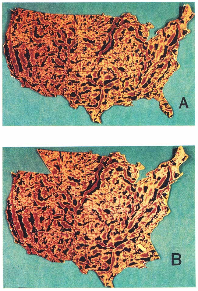
Figure 1--A) Reproduction of the wavelength-filtered (250-km [150-mi] cutoff, short wavelengths passed) Bouguer gravity map of Hildenbrand et al. (1982). B) Data of fig. 1A cut and recombined to imply a left-lateral strike-slip fault of approximately 800-km (480-mi) offset. A circular arc was chosen to facilitate the display. Certainly, a fault system is neither such a simple curve nor as narrow. Better correlations can be made for individual regions by more realistic cuts. For example, the cut in the Hartville uplift region falls slightly too far north, being within Black Hills structures.
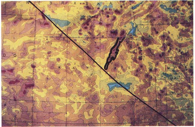
If the Central North American rift system (CNARS) does not terminate in central Kansas, it certainly changes considerably there. The rock types which are characteristic of the CNARS do not exist at the surface of the basement in southern Kansas (Bickford et al., 1979). Figs. 2 and 3 illustrate that both the gravity and magnetic signatures characteristic of the CNARS terminate in central Kansas. If the CNARS continues through southern Kansas, then the surficial basement-rock types and the gravity and magnetic signatures of the continuation are markedly different from those of the CNARS where its existence is well established.
Figure 2--Enlarged central region of fig. 1A.
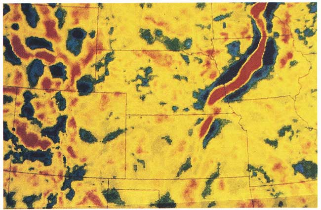
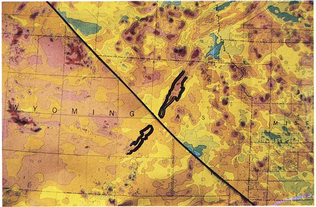
Figure 3--Kansas region of the National Magnetic Anomaly Map, Zietz (1982). The CNARS anomaly in Kansas is outlined and the line of the NATTF indicated.
Figs. 2 and 5 illustrate the gravity and magnetic signatures of the Hartville uplift in Wyoming (the location of the Hartville uplift is shown in fig. 4). Among the uplifts of the Wyoming area, the Hartville uplift is unusual in that it is a relatively minor uplift, yet it has a large, distinct gravity anomaly and a well-defined, narrow, magnetic anomaly. In fig. 2 the gravity anomaly of the Hartville uplift merges with that of the Black Hills; however, there is a discontinuity in gravity-anomaly pattern and trend coincident with the structural discontinuity between the Hartville uplift and the Black Hills.
Figure 4--Wyoming area structural uplifts after Seyfert and Sirkin (1979).
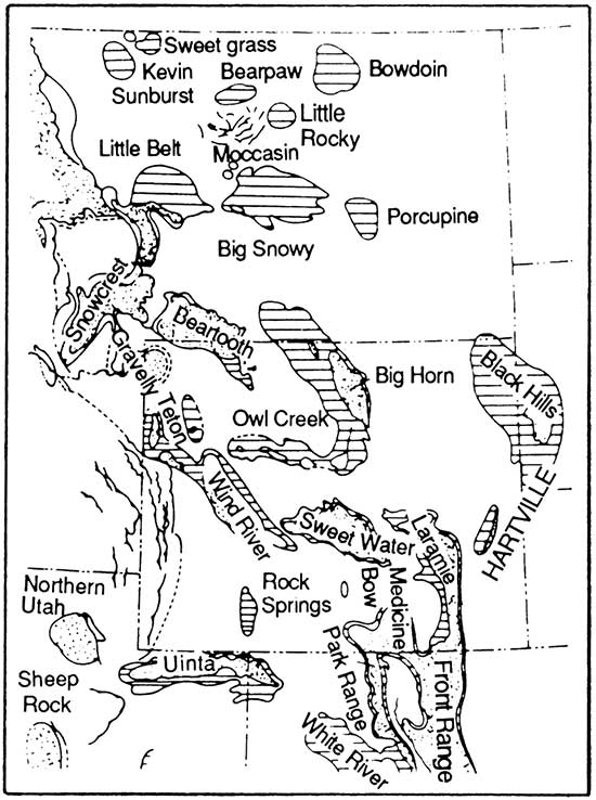
Figure 5--Correlation of anomalies of the CNARS in Kansas and the Hartville uplift in Wyoming after offset of the National Magnetic Anomaly Map (Zietz, 1982) along the inferred NATTF. The cut of this map was produced under the same criteria as that of fig. 1b and deserves the same comment.
Both the CNARS and the Hartville uplift exhibit discontinuities at the proposed NATTF. Fig. 1b shows the correlation of gravity anomalies of the CNARS and the Hartville uplift, when palinspastic reconstruction along the NATTF is performed. Fig. 5 illustrates the correlation for magnetic data.
The implication of the reconstruction is that the Hartville uplift is the continuation of the ancient (about 1,100 m.y.B.P.) CNARS. The gravity signature of the Hartville uplift is relatively large for the size of uplift, possibly due to the existence of a separate. buried. high-density body. as is true of the gravity anomaly of the CNARS (Somanas et al., this volume; Serpa et al., this volume). rather than being due to simple uplift of deeper, denser rocks. The sharp, well-aligned, magnetic anomaly of the Hartville uplift, which is uncharacteristic of the Wyoming area uplifts, may also result from a separate high-susceptibility source. much as the magnetic anomaly of the CNARS is thought to be due to rift-phase, basic intrusives emplaced above the Curie isotherm (Somanas et al., this volume).
Humphris and Kinsland (1987) have performed numerical gravity and magnetic modeling comparisons of the CNARS and the Hartville uplift. These studies show that the hypothesis of similar rift origin for the two features is consistent with all available geologic. gravity, magnetic. and seismic data. (However. other hypotheses also are consistent with the same data.)
Yarger (this volume) presents magnetic evidence in southern Kansas of features paralleling the CNARS trend. Even at the resolution of figs. la and 2, gravity anomalies are apparent in southern Kansas generally paralleling the CNARS, though they are of quite different style.
I believe these evidences of CNARS extension are due to relatively minor reactivation of the CNARS after the offset along the NATTF. Development of the Nemaha Ridge system in the mid- to late-Paleozoic indicates tectonic activity in both northern and southern Kansas well after the proposed NATTF event, an event lasting 20-40 m.y., assuming an offset rate of 2-4 cm/yr (.8-1.6 inches/yr) for the approximately 800-km (480-mi) offset. Since structural and proximity relationships suggest that the Nemaha structures and the CNARS may be related, development of the Nemaha during the Paleozoic in both north and south Kansas may well have been accompanied by activity along the CNARS trend, specifically in southern Kansas. Thus, the crust of southern Kansas may be affected by mid- to late Paleozoic CNARS activity resulting in the observed anomalies.
If further study establishes the existence of the NATTF, there will be implications for exploration in Kansas. One implication is that prospects related to the CNARS may terminate in Kansas but continue in Wyoming. Another is that the many northwest-southeast-trending, high-angle basement faults which exist in the Central Kansas uplift (CKU) may be related to the many subparallel faults which are typical of large strike-slip fault zones, e.g., the many basin-forming faults of the San Andreas fault system. If the relationship is recognized, then predictive capability in CKU petroleum exploration will be enhanced. That such a fault zone as the NATTF would likely serve as a conduit for emplacement of mineralizing fluids derived from the deep crust and/or mantle is a third implication.
The existence of the NATTF is by no means proved nor has it been disproved; consequently, it remains as a valid scientific hypothesis. This paper shows that the continuation of the CNARS from northern Kansas into southern Kansas may be consistent with the NATTF theory. Indeed, the NATTF offers a viable explanation for the marked change in the CNARS in central Kansas.
Anderson, T. H., and Schmidt, V. A., 1983, The evolution of middle America and the Gulf of Mexico-Caribbean Sea region during Mesozoic time: Geological Society of America. Bulletin. v. 94, p. 941-966.
Bevis, M., and Gilbert, L., 1984, The regional fracture fabric of the southeast U. S. (abs.): EOS. American Geophysical Union, Transactions, Spring Annual Meeting. v. 65.
Bickford, M. E., Harrower, K. L., Nusbaum, R. L., Thomas, J. J., and Nelson. G. E., 1979. Preliminary geologic map of the Precambrian basement rocks of Kansas: Kansas Geological Survey, Map M-9 scale 1:500.000, 1 sheet. [available online]
Carey, S. W., 1976. The expanding earth--developments in geotectonics: Elsevier Scientific Publishing Co., Amsterdam, no. 10, p. 377-380.
Diment, W. H., Muller, D. H., Lavin, P. M., 1980, Basement tectonics of New York and Pennsylvania as revealed by gravity and magnetic studies; in, The Caledonides in the United States of America, D. R. Wones, ed.: Department of Geological Sciences. Virginia Polytechnic Institute and Slate University, Memoir no. 2, p. 221-227.
Fisk, H. N., 1944, Geological investigation of the alluvial valley of the lower Mississippi River: U.S. Army Corps of Engineers, Mississippi River Commission, 78 p.
Hildenbrand, T. G., Simpson, R. W., Godson, R. H., and Kane, M. F., 1982, Digital colored residual and regional Bouguer gravity maps of the conterminous United States with cut-off wavelengths of 250 km and 1.000 km: U. S. Geological Survey, Geophysical Investigations, Map GP-953-A. [available online]
Humphris, D. D., and Kinsland, G. L., 1987. Possibilities of similar rift histories for the Central North American Rift System in Kansas and the Hartville uplift in Wyoming (abs.): 7th International Conference on Basement Tectonics, Program; paper to appear in conference proceedings.
Kinsland, G. L., 1982. Transcontinental transform? (abs.): American Geophysical Union, Spring Meeting, Program and Additional Abstracts, p. 49.
Kinsland, G. L., 1983a, Transcontinental strike-slip fault (abs.): EOS. American Geophysical Union, Transactions. v. 64. no. 18, p. 320.
Kinsland, G. L., 1983b, Transcontinental strike-slip fault across North America; in, Proceedings of the 5th International Conference on Basement Tectonics, S. Riad and D. L. Baars, eds.: International Basement Tectonics Association, Publication No. 5, p. 267-284.
Kinsland, G. L., 1984a, Color cover and caption: EOS, American Geophysical Union, Transactions. v , 65, no. 35.
Kinsland, G. L., 1984b, Basement structure of the Gulf coast--interpretation of gravity anomalies supported with structural, magnetic, and seismic data: Gulf Coast Association of Geological Societies, Transactions, v. 34, p. 85-94.
Muehlberger, W. R., 1980, Texas lineament revisited; in, New Mexico Geological Society Guidebook, 31st Field Conference, Trans Pecos Region, p. 113-121.
Seyfert, C., and Sirkin, L., 1979, Earth history and plate tectonics--an introduction to historical geology: Harper and Row Publishers, Inc., New York, 409 p.
Sykes, L. R., 1978, Intraplate seismicity, reactivation of preexisting zones of weakness, alkaline magnetism, and other tectonism post-dating continental fragmentation: Reviews of Geophysics and Space Physics, v. 16, no. 4, p. 621-688.
Zietz, I., 1982, Composite magnetic anomaly map of the United States, conterminous United States: U. S. Geological Survey, Geological Investigation, Map GP-954-A, part a. [available online]
Kansas Geological Survey
Comments to webadmin@kgs.ku.edu
Web version Sept. 17, 2013. Original publication date 1989.
URL=http://www.kgs.ku.edu/Publications/Bulletins/226/Kinsland/index.html