![]()
Prev Page--Geography || Next Page--Sections, Johnson Co.
Stratigraphy
The oldest rocks exposed in the Johnson and Miami County area belong to the division of rocks called the Pennsylvanian system, so named because of their great development in Pennsylvania. These rocks consist in eastern Kansas of interbedded layers of shale, limestone, and sandstone. Most of the formations were deposited in the sea, a conclusion well supported by the occurrence in them of abundant shells of marine animals.
Other deposits are glacial gravels and clay that were brought to the valley of Kansas river by a vast ice sheet, a continental glacier, that covered much of the upper part of the Mississippi Valley region during a part of the Pleistocene epoch. These gravels contain fragments of quartzite of the kind found as bedrock in southwestern Minnesota and adjacent parts of South Dakota and Iowa. Ice-transported boulders and pebbles of this rock are common in glacial deposits of Iowa, Missouri, Nebraska, and northeastern Kansas. Deposits of loess blown from the river flood plains along Missouri and Kansas rivers and redeposited on the uplands bordering the valleys occur in northern Johnson County. The loess of this area is connected in origin with the ice invasion and is composed in part of the finely ground rock dust brought from the northern area by the glacier. Younger deposits of recent age collectively make up the soil covering and flood-plain alluvium.
Pennsylvanian System
The thin beds of alternating shale, limestone, and sandstone that appear at the surface in eastern Kansas and adjacent parts of Missouri, Oklahoma, and Nebraska belong to the Pennsylvanian system. In much of the area of the Mid-Continent Coal Basin the rocks of Pennsylvanian age have generally been divided into two groups or series, the Des Moines series below and the Missouri series above. According to this classification of the strata, the Des Moines series is composed of the Cherokee and Marmaton groups, named in order from older to younger rocks. The Missouri beds, as defined in the past, include five groups, named in order upward, Kansas City, Lansing, Douglas, Shawnee, and Wabaunsee. Each of the groups contains a number of formations and many of these in turn are made up of smaller named units, called members.
The old classification of the Pennsylvanian rocks of the northern Mid-Continent region is unsuitable in several respects, and recent work has shown that it is based in many cases upon false premises. In order to formulate a more natural system of classification, one that is based upon modern knowledge of Mid-Continent stratigraphy, R. C. Moore has advanced a new classification of the Pennsylvanian system for the northern Mid-Continent region. [Moore, R. C., Guidebook, Sixth Annual Field Conference, Kansas Geol. Soc., 1932.]
Hinds and Greene have made known the occurrence of a major unconformity in the † Pleasanton formation, supposedly coincident with a widespread faunal break. [Hinds, Henry, and Greene, F. C., The stratigraphy of the Pennsylvanian series in Missouri: Missouri Bur. Geology and Mines, vol. 13, 2d ser., pp. 75-102, 1915. In accordance with a revised code of Rules of Stratigraphic Nomenclature recently formulated by a national committee of geologists, abandoned stratigraphic terms are designated by a dagger (†) preceding the term.] At this unconformity Moore proposes to place the lower limit of the Missouri series as redefined.
In their study of the Pennsylvanian rocks of Missouri, Hinds and Greene" also discovered a great channel sandstone lying between the Stanton and Oread formations in Platte county, Missouri, and the region about Leavenworth, Kan. [Hinds, Henry, and Greene, F. C., The stratigraphy of the Pennsylvanian series in Missouri: Missouri Bur. Geology and Mines, vol. 13, 2d ser., pp. 170-171, 1915.] This sandstone deposit was traced by J. M. Jewett and me across Wyandotte County. In the present study it was found that the sandstone, marking the base of the Stranger formation of this report, is continuous across Johnson and Franklin counties, and it has subsequently been traced into Oklahoma. In southeastern Kansas' sandstones of the Stranger formation produce a high escarpment that affords an abundance of good exposures. The formation extends almost continuously as a great sandstone sheet across Kansas, resting unconformably upon older rocks, in most places upon the clayey Weston shale, but in Leavenworth, Wyandotte, and northwestern Johnson counties lying in many localities on the upper member of the Stanton. In Leavenworth county the unconformity rises to the northward from the surface of the Stanton to a horizon above the Iatan limestone, showing conclusively that the Iatan was deposited before the widespread emergence. The stratigraphic interval which the unconformable contact overlaps amounts to more than seventy feet in the Leavenworth region. This unconformity has been selected by Moore as the upper limit of his Missouri series as redefined. In most of northeastern Kansas the upper boundary of the Missouri series coincides with the top of the Lansing group of older writers, but in northwestern Missouri and probably in southeastern Kansas -strata as young as the Iatan limestone lie below the unconformity. For the Pennsylvanian strata above the unconformity just described, Moore has proposed the term Virgil series.
It was discovered in the study of Johnson and Miami counties that certain miscorrelations have been made by previous geologists between the classic exposures at Kansas City and type localities in southeastern Kansas. My correlations were made by continuous tracing of outcrops, and were verified by Dr. R. C. Moore, state geologist. The evidence for the present correlations is presented under the descriptions of formations in the following pages. J. M. Jewett, who is engaged in a study of the Bronson group, has made certain observations in southeast Kansas which affect the nomenclature of some of the formations.
In a recent publication J. M. Jewett proposed to abandon the term Hertha on the basis that it is a synonym of Bethany Falls. [, Jewett, J. M., Some details of the stratigraphy of the Bronson group of the Kansas Pennsylvanian Kansas Acad. Sci., Trans., vol., 86, pp. 131-186, 1983.] At the same time he introduced a number of terms for what he considered to be several disconnected lenticular limestones of slightly different stratigraphic position. F. C. Greene, R. C. Moore, and I have concluded, from an examination of field evidence, that possibly some errors were made by Jewett. It appeared to us that the Hertha limestone of general usage in the Kansas City is in reality part of the type Hertha. The problem is too involved to discuss at length here, but the classification of the lower Bronson units given in the present report is correct for northeastern Kansas and northwestern Missouri.
Some of the changes in correlation that affect classification and nomenclature of the rocks in Johnson and Miami counties are summarized as follows. The "Drum" limestone of Kansas City does not occur south of Martin City, Jackson county, Missouri (except possibly very locally in Miami County), and is not the equivalent of the type Drum limestone. The Cement City limestone of the Kansas City region is continuous with part of the type Drum, and the name Cement City is retained for the lower member of the Drum formation. The Raytown limestone is the exact equivalent of the upper part of the Iola limestone. The so-called Iola limestone at Kansas City does not occur at Iola, but is a previously unnamed unit. The Farley limestone coalesces in Miami County with the "Iola" of the Kansas City area to form an indivisible unit which contains the so-called Lansing brachiopod Enteletes throughout. The Kansas City and Lansing groups of authors cannot be divided either faunally or lithologically over much of eastern Kansas. The original description of the Stanton limestone refers to the previously named Plattsburg. It is proposed here, however, to retain the terms Plattsburg and Stanton in their current usage, because by so doing there is a minimum of confusion. The unconformity that occurs in the part of the section lying between the Stanton and Oread formations is easily recognized throughout most of eastern Kansas. It marks the base of a more or less continuous sandstone sheet older than the Lawrence and younger than the type Iatan. The limestone at Lawrence which marks the lower boundary of the Lawrence shale is not the Iatan, because it is well above the unconformity. Moore has termed this limestone at the base of the Lawrence the Haskell limestone.
Moore has suggested that the beds above the Des Moines-Missouri unconformity to the top of the Pleasanton of authors constitue a natural stratigraphic unit consisting mostly of shale. [Moore, R. C., A reclassification of the Pennsylvanian system in the northern MidContinent region, Guidebook, Sixth Annual Field Conference, Kansas Geol, Soc., pp. 79-97, 1932.] This he terms the Bourbon formation. For the persistent limestones and shales above the Bourbon to the top of the Winterset he has revived Adams' term, "Bronson," employing it in the original sense as regards stratigraphic boundaries, but classing it as a group rather than a formation. The highly variable and dominantly shaly strata between the top of the Winterset and the base of the Plattsburg formation he calls the Kansas City group. It will be noted that this involves revision of both the lower and upper boundaries of the Kansas City beds as proposed by Hinds and Greene, but it is the view of a large number of Mid-Continent geologists that it is preferable to retain this familiar name in a revised sense rather than to drop it in favor of an entirely new term. The persistent limestone strata between the base of the Plattsburg and the top of the Stanton are termed by Moore the Lansing group.
| Generalized section of the Pennsylvanian rocks exposed in Johnson and Miami counties | Feet | ||||
|---|---|---|---|---|---|
| Virgil series: | |||||
| Douglas group: | |||||
| Stranger formation: | |||||
| Sandstone, buff, soft, cross-bedded, erosion remnant | 40+ | ||||
| Unconformity | |||||
| Missouri series: | |||||
| Pedee group: | |||||
| Weston shale | 0-40 | ||||
| Lansing group: | |||||
| Stanton limestone: | |||||
| Little Kaw limestone member: | |||||
| Limestone, bluish-gray, blocky | 2± | ||||
| Victory Junction shale member: | |||||
| Shale below, and brown sandstone above | 3-14 | ||||
| Olathe limestone member: | |||||
| Limestone, bluish-gray, thin-bedded, wavy | 11-15 | ||||
| Eudora shale member: | |||||
| Shale, carbonaceous, black | 4-11 | ||||
| Captain Creek limestone member: | |||||
| Limestone, dark-gray, even-bedded | 4-10 | ||||
| Vilas shale: | |||||
| Shale, gray, arenaceous | 5-30 | ||||
| Plattsburg limestone: | |||||
| Spring Hill limestone member: | |||||
| Limestone, drab or buff, even-bedded | 10± | ||||
| Hickory Creek shale member: | |||||
| Shale, yellowish, nodular, locally with a carbonaceous layer | 1± | ||||
| Merriam limestone member: | |||||
| Limestone, gray, blocky, even-bedded | 3± | ||||
| Kansas City group: | |||||
| Bonner Springs shale: | |||||
| Shale, olive-green, argillaceous, maroon layer near top | 25± | ||||
| Wyandotte limestone: | |||||
| Farley limestone member: | |||||
| Limestone, light-gray, thin-bedded, wavy | 10± | ||||
| Island Creek shale member: | |||||
| Shale, gray, limy, absent in Miami County | 0-5 | ||||
| Argentine limestone member: | |||||
| Limestone, light-gray, thin-bedded, wavy | 25± | ||||
| Quindaro shale member: | |||||
| Shale, gray, argillaceous or limy | 3± | ||||
| Frisbie limestone member: | |||||
| Limestone, gray, even, blocky, in one layer | 2± | ||||
| Lane shale: | |||||
| Shale, gray or buff, argillaceous, sandy where thick | 16-105 | ||||
| Iola limestone: | |||||
| Raytown limestone member: | |||||
| Limestone, bluish-gray, even-bedded | 5-13 | ||||
| Muncie Creek shale member: | |||||
| Shale, carbonaceous where thick, argillaceous where thin, with spherical phosphatic concretions | 0.5-3 | ||||
| Paola limestone member: | |||||
| Limestone, bluish-gray, even, blocky | 1.5 | ||||
| Chanute shale: | |||||
| Shale, lower half argillaceous, upper half arenaceous (Cottage Grove sandstone), Thayer coal bed near the middle in southern Miami County | 8-38 | ||||
| Drum limestone: | |||||
| Cement City limestone member: | |||||
| Limestone, ferruginous, drab or brown, thick-bedded | 2-10 | ||||
| Quivira shale: | |||||
| Shale, black, carbonaceous, argillaceous above and below | 4-11 | ||||
| Westerville limestone: | |||||
| Limestone, drab, irregular, oolitic where thick | 0-20 | ||||
| Wea shale: | |||||
| Shale, argillaceous or calcareous, greenish or gray | 10-30 | ||||
| Block limestone: | |||||
| Limestone and calcareous buff shale, more shaly in Johnson County | 6± | ||||
| Fontana shale: | |||||
| Shale, gray or buff, argillaceous or calcareous | 5-25 | ||||
| Bronson group: | |||||
| Dennis limestone: | |||||
| Winterset limestone member: | |||||
| Limestone, gray, even, thin-bedded | 30 | ||||
| Stark shale member: | |||||
| Shale, black, carbonaceous below, argillaceous above | 4-7 | ||||
| Galesburg shale: | |||||
| Shale, buff, argillaceous or calcareous | 2-3 | ||||
| Swope limestone: | |||||
| Bethany Falls limestone member: | |||||
| Limestone, drab, massive, oolitic above | 13-27 | ||||
| Hushpuckney shale member: | |||||
| Shale, black, platy, with clay layer above and below | 5 | ||||
| Middle Creek limestone member: | |||||
| Limestone, bluish, even, blocky, two beds generally | 2 | ||||
| Ladore shale: | |||||
| Shale, buff, argillaceous, calcareous below | 7± | ||||
| Hertha limestone: | |||||
| Sniabar limestone member: | |||||
| Limestone, thick-bedded, ferruginous | 6 | ||||
| Bourbon formation: | |||||
| Shale, limy, ferruginous | 4± | ||||
| Limestone, nodular, ferruginous, very persistent | 2± | ||||
| Shale with channel sandstones, which possibly represent the Des Moines-Missouri boundary | 80± | ||||
Missouri Series
The term Marmaton was applied by Haworth to a thick limestone and shale succession lying between the Cherokee and the top of the Des Moines series as generally defined. Following the new usage proposed by Moore the upper limit of the Marmaton is lowered to the unconformity some scores of feet below the Kansas City group of current usage.
The Marmaton group is divided into several formations. These are, in ascending order: Fort Scott limestone, Labette shale, Pawnee limestone, Bandera shale, Altamont limestone, Nowata shale, Lenapah limestone, and Dudley shale. Because the Des Moines-Missouri boundary lies within and probably near the base of the Dudley shale it is advisable to abandon the term Dudley.
At one locality in Miami County, described below, there occurs just below the limestones of the Bronson group or lower "Kansas City" a local sandstone, seemingly a channel filling. It has not been determined as yet whether or not this channel marks the Des Moines-Missouri unconformity, but I am inclined to believe that it is stratigraphically higher than the base of the Missouri series. Thin fossiliferous limestones seen south of the Miami area and apparently occurring below the horizon 01 the channel sandstone alluded to above have not yielded Des Moines guide fossils. In the present discussion, therefore, it will be assumed that the lowest shale exposed in the area under consideration is the Bourbon shale, belonging in the Missouri series, and that the channel sandstone in southeastern Miami County does not mark the Des Moines-Missouri boundary.
The term Missouri was proposed by Keyes to include the "upper Coal Measures," that is, the higher part of the Pennsylvanian section as developed in northwestern Missouri. [Keyes, C. R., The geological formations of Iowa: Iowa Geol. Survey, vol. 1, pp. 85- 114, 1893.] Through usage the term has come to be applied to all of the Upper Pennsylvanian rocks in the northern Mid-Continent. Moore has redefined the term Missouri to apply to strata between the two extensive unconformities in the mid portion of the Mid-Continent Pennsylvanian, namely that above the Marmaton and the break shortly above the Stanton limestone.
The term Pottawatomie, from Pottawatomie creek in eastern Kansas, was applied by Haworth to strata included in Moore's Missouri series. [Haworth, E., Univ. Geol. Survey of Kansas, vol. 3, p. 94, 1898.] The term Pottawatomie, however, in the original sense does not apply to a natural unit, and the section along Pottawatomie creek is neither a desirable one for a type section nor does it include all of the strata of Haworth's Pottawatomie formation. Moore has deemed it more desirable to retain the widely used name Missouri than to revive Haworth's little-used term.
Hinds proposed to divide the old Pottawatomie formation into two divisions, the Kansas City and Lansing. [Hinds, Henry, Coal deposits of Missouri: Missouri Bur. Geology and Mines, vol. 2, 2d ser., p. 7, 1912.] This course was seemingly substantiated by both lithologic and faunal evidence and the classification has come into general usage. It is shown below, however, that the Kansas City division over great areas cannot be separated from the Lansing, either lithologically or faunally.
It is partly upon evidence presented in the following pages that Moore proposes to divide the redefined Missouri series into five groups, called Bourbon, Bronson, Kansas City, Lansing, and at the top Pedee. Kansas City and Lansing have been previously employed in a somewhat different sense.
Bourbon Formation
For the beds, consisting chiefly of shale in most places, between the unconformity at the base of the Missouri series and the base of the Hertha limestone, Moore proposes the term Bourbon, from a county in eastern Kansas. [Moore, R. C., Op. cit., p. 90.] As explained under the discussion of the Missouri series, the thick shale around La Cygne and in southeastern Miami County belongs largely or entirely to the Bourbon formation.
Lithologic character and thickness. In Miami County the lower part of the Bourbon is not shown, being below drainage level. A channel sandstone occurs in the upper part of the formation near the middle of the south edge of section 9, T. 19 S., R. 25 E. The deposit consists of soft cross-bedded sandstone having an estimated thickness of possibly fifty feet or more and a breadth at the outcrop of about a quarter of a mile. At other places in southeastern Miami County and at La Cygne, in Linn County, there is at the same horizon buff arenaceous shale and thin beds of sandstone. The shale succeeding the channel deposit in Miami County is generally arenaceous with intercalated layers of clay. It is about thirty feet or so thick.
The base of the Bourbon is not exposed in the vicinity of Miami County, so it is impossible to obtain the exact thickness from surface data. There is, however, about ninety feet of the formation exposed along the tributaries of Marais des Cygnes river in the southeastern part of the county. Near the top of the Bourbon formation there is a thin bed of nodular, ferruginous tan limestone, one or two feet thick, bearing, at least locally, specimens of a large Bellerophon, as does the overlying Sniabar. This limestone is the one called Critizer by Jewett. [Jewett, J. M., Kansas Acad. Sci., Trans., vol. 36, p. 134, 1933.] The term Critizer possibly cannot rightly be applied to this limestone because it seemed to F. C. Greene, R. C. Moore, and me that the limestone near Critizer in Linn County is another one. The upper shale of the Bourbon in Miami County consists of four feet or less of nodular greenish clay.
Since the Bethany Falls limestone is the lowest rock exposed in Johnson County, the Bourbon does not crop out within the limits of that county.
Detailed sections. Sections including part of the Bourbon formation are given under numbers 125, 158, and 159 at the end of the report.
Plate III--Exposures of the Swope formation, SE cor. sec. 36, T. 19 S., R. 24 E., Linn County. A--Bethany Falls limestone. B--Middle Creek limestone (type exposure) above pavement and Hushpuckney shale above.
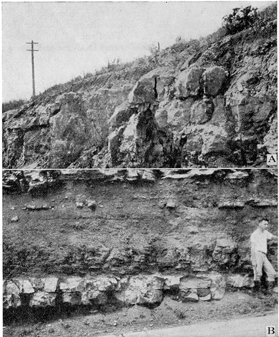
Plate IV--A--Drum limestone. Local cross-bedded limestone at the top. SE cor, sec. 31, T. 16 S., R. 24 E., Miami County. B--Characteristic Drum limestone at the middle of the west edge sec. 21, T. 17 S., R. 23 E., Miami County.
Bronson Group
The name Bronson was used by Adams for three principal limestones, and included shales. [Adams, G. I., U. S. Geol. Survey, Bull 238, pp, 17, 18, 1904.] above the "Dudley" shale in southeastern Kansas. At first he thought that the limestone should be correlated with the Hertha, Dennis, and Drum, but before the description of the Bronson was published he was acquainted with the true correlation of the units with which he was dealing and made the proper corrections in an inserted list of errata in this publication. Thus, Adams meant to include three principal limestones and contained shales in his Bronson up to the top of the Dennis limestone, or Winterset of modern writers.
Hertha Limestone
The name Hertha was introduced by Adams "for the limestones succeeding the upper Pleasanton shales as exposed in the vicinity of Hertha," Neosho county, Kansas. [Adams, G. I., in Adams, Girty, and White, Upper Carboniferous rocks of the Kansas section: U. S. Geol. Survey, Bull. 211, p. 35, 1903.] Jewett rightly concluded that the limestone to which the name Hertha was applied at Hertha by Adams in 1903 is the Bethany Falls limestone. [Jewett, J. M., Kansas Acad, Sci., Trans., vol. 36, p. 134, 1933.] It is possible to determine the exact bed at Hertha referred to by Adams in this publication because an areal map of eastern Kansas, showing the distribution of the Hertha and other limestone outcrops, accompanied the original definition.
A year after the first definition of Hertha, Adams published maps of the area immediately north of Hertha in which the first limestone below the Bethany Falls (= Mound Valley limestone) was indicated as Hertha. [Adams, G. I., in Adams, Haworth, and Crane, Economic geology of the Iola quadrangle, Kansas: U. S. Geol. Survey, Bull. 238, pp. 14 and 16, 1904.] This lower limestone is the six-foot limestone cropping out at Hertha, and not the one shown as Hertha in the previous publication. The reason for this confusing change in mapping was not given in the accompanying text. In the application of the term Hertha the early Kansas Survey followed this second usage of Adams so that, excepting for the original definition, the name Hertha has been consistently applied to the lower limestone of the Bronson group.
It was discovered by F. C. Greene, R. C. Moore, and me, in a special field investigation of the Hertha problem that the lower limestone cropping out at Hertha is continuous across eastern Kansas, and, contrary to Jewett's conclusion, it is in part equivalent to the limestone at Kansas City that has in the past been called Hertha. [Jewett, J. M., Kansas Acad, Sci., Trans., vol. 36, p. 134, 1933.]
It does not seem advisable to suppress the name Hertha on the grounds that it is a synonym of Bethany Falls. In Adam's final usage and subsequent work it appears that there has been a consistent application of the name to one limestone unit, the lower of the Bronson or "triple system" of the early writers. I propose here to retain the term Hertha in a formational sense for the limestone cropping out at Hertha, and for its immediate correlatives.
In tracing the Hertha southward from Kansas it was discovered by Greene, Moore, and me that the unit is added to above so that over much of eastern Kansas it is divisible into two members of unlike lithologic character, commonly separated by some shale. The upper member was thought to be Jewett's Schubert Creek limestone and the lower one, so well-developed in northeastern Kansas and adjoining parts of Missouri, is here termed the Sniabar limestone from exposures along Sniabar creek in southeastern Jackson county, Missouri. A characteristic exposure may be seen along the highway one half mile north of Knobtown, Jackson county, Missouri.
Lithologic character and thickness. The Sniabar limestone is exposed at a few places in the southeastern part of Miami County. It is commonly covered by the large slumped blocks of the Bethany Falls limestone above. The Sniabar limestone consists of thick-bedded, ferruginous, fine-grained limestone, generally drab or gray where fresh, and brown on weathered surfaces. The uppermost part of the limestone is granular and contains Osagia sp. readily visible on fresh surfaces. The member generally consists of a single bed of limestone, and only exceptionally are bedding planes shown. It averages six feet thick in Miami County, although at one locality in sec. 10, T. 19 S., R. 24 E., it is only five feet thick. The unit is rather unfossiliferous. A careful search in Miami County for fusulinids in the Sniabar limestone has been fruitless.
Distribution. The outcrop of the Sniabar limestone is restricted in Miami County to the (1) valley of Sugar creek and the lower part of its principal tributaries, (2) the lower part of Middle creek, (3) the valley of Marais des Cygnes river, extending to the northeast part of township 18 south, range 23 east, and (4) Hushpuckney creek valley in township 19 south, range 23 east. The formation does not crop out in Johnson County.
Detailed sections. Sections of the Sniabar limestone are given under numbers 122, 124, 125, 152, 157, 158, and 159 in the register at the end of the report.
Ladore Shale
The term Ladore was applied by Adams to the shale between the Hertha and Mound Valley (Bethany Falls) limestones as shown near Ladore. [Adams, G. I., in Adams, Haworth, and Crane, U. S. Geol. Survey, Bull. 238, map opposite p. 14, 1904.] Since the upper limestone layers of the Hertha appear generally to be lacking in northeastern Kansas, the Ladore shale may include slightly lower beds than in southern Kansas, but, on the other hand, Middle Creek limestone and overlying Hushpuckney shale which may be represented by the upper Ladore in southern sections are excluded from the Ladore in the north. The Ladore shale of northeastern Kansas is not nearly as thick as it is in southeastern Kansas.
Lithologic character and thickness: The Ladore shale crops out in Miami County, where it consists chiefly of buff to gray argillaceous shale. Generally the lower part is limy and nodular. The upper portion locally contains thin lenticular shaly limestones, but more commonly it is argillaceous throughout. The formation ranges in thickness from five to twelve feet, but averages about five and one half feet. A typical section at the west edge of the NE of sec. 10, T. 19 S., R. 23 E. shows two feet of greenish-buff, limy shale, overlain by five inches of soft, gray, argillaceous limestone, and three feet three inches of argillaceous, gray shale with a thin limestone at the middle. The formation is relatively thick at the middle of the south edge of sec. 18, T. 18 S., R. 24 E., where it reaches a thickness of twelve feet.
Swope Limestone
The term Swope, from Swope Park, Kansas City, Mo., is proposed by Moore and Newell for the persistent limestones and thin shales from the top of the Ladore shale to the top of the Bethany Falls limestone. The units of the Swope are, in ascending order: Middle creek limestone, Hushpuckney shale, and Bethany Falls limestone.
Lithologic character and thickness. The lowest member of the Swope, the Middle creek limestone, is named from the exposures on the east side of Middle Creek at the highway three miles east of La Cygne, Linn County, Kansas. The member is exceedingly uniform throughout Kansas and Missouri. It consists generally in Miami County of two even layers of dark bluish-gray, dense, and brittle limestone. Only locally in the area are the two layers separated by shale, as at the west edge of the NE sec. 10, T. 19 S., R. 23 E., where the section from the base upward is one and one half feet of bluish-gray, lithographic even limestone, five inches of limy buff shale with batostomellids, overlain by four and one half inches of bluish-gray dense limestone. At some localities the upper surface of the lower bed of the Middle Creek limestone is covered with a peculiar twig-like form which recalls certain types of the alga Lithothamnion. The member is quite uniform in thickness, ranging in this region from about one foot four inches to a maximum of two feet three inches. Where there is no included shale the Middle Creek is commonly one foot eight inches thick. The Middle Creek limestone strikingly duplicates in its physical characters and in its> position immediately beneath black fissile shale the "middle limestone" members of the limestone formations in the Shawnee group, where Moore has defined the typical sequence of units in regularly repeated sedimentation cycles. In terms of this cycle, therefore, the Middle Creek member may be classed as a "middle limestone."
The Hushpuckney shale, here named from a creek south of Fontana, in Miami County, is similar to many of the thin carbonaceous shales in the Mid-Continent region. It is typically shown at a railroad cut, center north side sec. 13, T. 19 S., R. 23 E. (Loc. 124). It consists typically of two parts, the upper half being gray, argillaceous shale, and the lower half black, platy shale. Locally a thin layer of argillaceous, greenish shale underlies the black shale, and less commonly the upper part of the member consists of carbonaceous, blocky shale. The carbonaceous parts of the unit are not very fossiliferous, but in places they yield orbiculoid brachiopods. At Middle creek, about one fourth of a mile east of the SW cor. sec. 22, T. 18 S., R. 24 E., a few impressions of the scales of a large ganoid fish occur in the black platy shale. Small phosphatic nodules are rather common in the carbonaceous part of the shale. The thickness of the Hushpuckney member ranges from four and one half to five and one half feet, the average being closer to the latter figure.
The Bethany Falls limestone, named by Broadhead from exposures at the falls of Big creek, near Bethany, Mo., is an easily recognized unit where it is fairly well exposed. [Broadhead, G. C., Coal Measures in Missouri: St. Louis Acad. Sci., Trans., vol. 2, p, 320, 1868 (read May 5, 1862, first issued July 27, 1865).] The member in Miami County is similar to exposures in the vicinity of Kansas City and elsewhere in eastern Kansas. The upper part is massive, drab or light gray, oolitic, and cross-bedded. Locally, there is a thin layer of loose limestone nodules at the top. The uppermost part of the massive bed is at a few places mottled with bluish-gray spots. The oolitic part is quite unfossiliferous, and locally contains peculiar vertical tubular cavities measuring as much as five feet in length by two inches in diameter. Generally the cavities are lined by iron-stained calcite crystals, and less commonly they are nearly or entirely filled with calcite. Where the rock is weathered the oolitic grains have in most cases been removed by solution, leaving minute spherical cavities surrounded by the limestone matrix. The massive upper part of the Bethany Falls weathers in great rounded masses, which creep down the slopes in huge blocks, or it crops out as a massive ledge along valley slopes. There is considerable variation in the thickness of this part of the member. It ranges from about one foot at the center of the south edge of sec. 18, T. 18 S., R. 24 E., to thirteen feet at the west edge of the NE sec. 10, T. 19 S., R. 23 E. In fact, most of the variation in thickness of the member is due to the irregularity of the oolitic part. The upper massive part of the Bethany Falls is commonly about seven feet thick.
The lower part of the member is quite distinct from the upper. It is composed of thin-bedded, even, whitish or light-gray limestone, containing an occasional light-colored chert nodule and a few brachiopods of the Productus type. A small fusulinid of the appearance of Triticites irregularis occurs here, the first appearance of Triticites in the section. This limestone generally weathers buff, especially below, where occur a few thin shale partings. This part of the member ranges between ten and nineteen feet, but most commonly measures about fourteen feet. The greatest thickness of the entire member in Miami County was measured at the west edge of the NE sec. 10, T. 19 S., R. 23 E., where it is twenty-seven feet thick. The member is thinnest at the center of the north edge of sec. 13, T. 19 S., R. 23 E., at a railroad cut, where it measures thirteen feet. Generally the member measures about eighteen feet in Miami County.
The lower thin-bedded Triticites-bearing part of the Bethany Falls member is entirely similar in physical and faunal characters and in its position above black platy shale to the so-called "upper limestone" of the limestone formations in the Shawnee group. The remaining upper part of the Bethany Falls, which is irregular in thickness and in various portions massive, oolitic, or nodular, is probably chiefly of algal origin. It duplicates characters that are typical of what Moore has termed the "super limestones" in the sedimentary cycle exhibited by the Shawnee group limestone formations. The Bethany Falls limestone thus contains both the "upper" and "super" elements of the cyclic succession of beds as described by Moore.
The outcrops of the Bethany Falls limestone extends into Johnson County from Missouri for a short distance along the lower part of Indian creek. Only the upper part of the member is exposed on the Kansas side. Very good exposures of the entire Swope formation occur a short distance to the east along Big Blue river in Jackson county, Missouri. The Bethany Falls limestone, which is the oldest member exposed in Johnson County, shows the characteristic features at the Indian creek exposure. It weathers in large, rounded masses, displaying few joints. The upper few feet of the member consists of drab, soft, highly nodular and rather unfossiliferous limestone. In near-by areas where the entire member is exposed, the upper part of the Bethany Falls is very massive and is oolitic or nodular. This part of the formation has a tendency to form large slumped blocks which hide the lower and less massive part. This peculiar feature of weathering is excellently displayed in the outcrops in Swope Park in Kansas City and to the southward along the valley of the Big Blue. The lower part of the Bethany Falls in the Jackson county exposures resembles the exposures in Miami County, consisting of even-bedded, gray limestone with a few thin shale partings. The entire Swope limestone is about twenty feet thick in the exposures nearest the Johnson County line.
Distribution. The Swope formation crops out in Miami County along the principal streams in the southeastern part. On Sugar and Middle creeks it extends to about the middle of township 18 south, and along Marais des Cygnes river to a point west of the center of township 18 south, range 23 east, where it is seen at the water's edge beneath the highway bridge in section 17. On Mound creek, southeast of Beagle, the formation is exposed as far as the western edge of range 23 east.
In Johnson County the Swope limestone is exposed near stream level on Indian creek at the state line. At other places in the county it is covered by younger formations.
Detailed sections. Sections of the Swope are given under numbers 121, 122, 123, 124, 125, 126, 130, 152, 154, 157, 158, and 159.
Galesburg Shale
The Galesburg shale was named by Adams from Galesburg, Neosho county, Kansas. [Adams, G. I., Stratigraphy and paleontology of the Upper Carboniferous rocks of the Kansas section: U. S. Geol. Survey, Bull. 211, p. 36, 1903.] According to Adams' original definition, it includes "the rocks occupying the interval between the Hertha limestone and the Dennis limestone." It has been generally assumed that Adams overlooked the Bethany Falls limestone at Galesburg, since that formation lies between the Hertha and the Dennis. Because the term Ladore was used for the shale between the Hertha and Bethany Falls the name Galesburg was restricted by the early Kansas Survey to apply to the strata between the Mound Valley (Bethany Falls) and the Dennis limestones.
In southeastern Kansas, extending as far north as Linn County, there is a thin, blocky, blue limestone below the Winterset limestone, separated from it by a thin black shale. This limestone was known to the older writers and to Hinds and Greene. [Hinds, Henry, and Greene, F. C., The stratigraphy of the Pennsylvanian series in Missouri: Missouri Bur. Geol. and Mines, vol. 13, 2d ser., Table Opp. p. 119, 1915.] Jewett has determined that the limestone is absent in northern Linn County and that it makes its appearance to the southward. This limestone, called Canville by Jewett, and the black shale above lie at the horizon of the upper part of the so-called Galesburg in the Kansas City region. In northeastern Kansas the section above the Bethany Falls is as follows: a thin layer of buff or gray clay shale is overlain by two or three feet of black fissile shale, which is in turn overlain by a thin layer of buff or gray clay. The Winterset overlies this clastic succession.
According to Jewett, the situation at Galesburg is as follows. A thick shale and sandstone section, the Galesburg shale, is overlain by a limestone formation which consists of three parts; a lower thin, blocky limestone, overlain by a thin shale containing a layer of black fissile shale, succeeded by a thick limestone. The older writers did not mention any limestone or black shale in the typical Galesburg, and it is almost certain that the rather obscure black shale layer and basal limestone were grouped with the main limestone above under the term Dennis. This succession, which occurs at Dennis as well as Galesburg, is not easily recognized at all exposures because the lower units are commonly hidden by slumped blocks of the much thicker upper member.
The shale below the thin basal limestone has thinned in the vicinity of Uniontown from over seventy feet to about ten feet. Farther north the unit thins even more, to less than three feet in Miami County. The view is here taken that this shale in Miami County is the true Galesburg shale, on the basis of stratigraphic continuity and because the black shale above, which in southeastern Kansas is underlain by a thin limestone, belongs genetically with the limestone above. The thin blocky limestone is replaced by shale to the northward, so that in Miami and Johnson counties the Galesburg is directly overlain by the black shale which Jewett has called the Stark shale. The Canville limestone and Stark shale are classed with the Winterset limestone as members of the Dennis limestone.
Lithologic character and thickness. The Galesburg is fairly uniform in its characters in Miami County. The unit is underlain by the Bethany Falls member of the Swope and overlain by black fissile shale, the Stark. A characteristic section of the Galesburg occurs two and one half miles east of La Cygne, Linn County. From the base upward there is two feet four inches of buff, limy, nodular shale, and four inches of buff, limy, hard shale, rarely bearing Leiorhynchus rockymountanum. The hard shale is probably the equivalent of the dense, blue Canville limestone that occurs at this horizon a short distance to the south.
The Galesburg is not well exposed in Johnson County and, like the Bethany Falls, crops out only at the NW cor. sec. 11, T. 12 S, R. 25 E., in the bed of Indian creek. The formation is generally about two feet thick in near-by areas and becomes increasingly argillaceous and less calcareous toward Kansas City.
Distribution. In Miami County the formation crops out along the major streams in the southern part of the county. The Galesburg extends along the forks of Sugar creek almost to the middle of township 18 south. It crops out along Middle creek to a point north of the center of township 18 south, range 24 east, and extends nearly to the west edge of range 23 east on Marais des Cygnes river, where the formation dips below the plain southeast of Henson. On Mound creek the Galesburg crops out upstream to about the west edge of range 23 east.
The only occurrence of the Galesburg in Johnson County is given above.
Detailed sections. Sections of the Galesburg are given under locality numbers 121, 122, 123, 124, 130, 152, 154, and 159.
Dennis Limestone
The term Dennis, from a town in Labette county, Kansas, was applied by Adams to a formation which he considered to be the same as the previously named Mound Valley limestone. [Adams, G. I., Stratigraphy and paleontology of the Upper Carboniferous rocks of the Kansas section: U. S. Geol. Survey, Bull. 211, p. 36, 1903.] The Kansas Survey, however, maintained that the Mound Valley, or Bethany Falls of modern writers, and the Dennis were different formations. Later it was found that the Winterset limestone of Iowa geologists could be correlated with the Dennis, and the older term Winterset was retained. [Tilton, J. L., and Bain, H. F., Geology of Madison county: Iowa Geol. Survey, vol. 7, pp. 517-519, 1897.] As explained under the discussion of the Galesburg, Jewett has found that the type Dennis consists of more than the Winterset limestone as interpreted by Missouri geologists. The limestone at Dennis contains three divisions. These are a basal, blocky, thin limestone, overlain by black fissile shale, and thick limestone. This is a duplication of the cycle exhibited by the Swope limestone. The basal limestone at Dennis extends northward along the outcrop as far as southern Linn County, beyond which it changes to limy shale. The black shale member, which Jewett calls the Stark, from a town in Neosho county, has always been considered a part of the Galesburg in the Kansas City region. [Jewett, J. M., Kansas Acad. Sci., Trans., vol. 36, p. 133, 1938.] In northeastern Kansas, including Johnson and Miami counties, the Stark is the lowermost member of the Dennis formation, since the basal limestone found in southeastern Kansas is unrecognizable in the northern area. The uppermost and most persistent member is the Winterset of standard usage. The Dennis formation as here used includes in northeastern Kansas the Stark shale below and the Winterset limestone above. In southeastern Kansas a third member, a basal, thin limestone, the Canville, occurs below the Stark. [Jewett, J. M., Kansas Acad. Sci., Trans., vol. 36, p. 133, 1938.]
Lithologic character and thickness. The Stark shale, lowermost member of the Dennis in northeastern Kansas, is generally quite uniform. It consists of black fissile shale below, overlain by a slightly thicker amount of gray or buff argillaceous shale. In Miami County the carbonaceous part of the member is two and one half to three feet thick and contains an abundance of phosphatic concretions. The upper part of the member consists of four and one half feet of buff and gray limy shale.
The member presents about the same character at the few outcrops in Johnson County. The upper part of the member is generally yellowish and underlain by gray argillaceous shale. The entire unit is about four feet at exposures in eastern Johnson County and adjoining parts of Missouri.
The Winterset limestone is more regular in Miami and Johnson counties than the Bethany Falls, with which it might be confused, but has characters less striking. In both counties the Winterset consists of gray, thin-bedded, even limestone, fine-grained or dense at the middle and veined or coarse below. In Miami County the uppermost part consists of dark-gray or nearly black, fine-grained limestone bearing a characteristic faunal assemblage. At one locality, just west of the NE cor. section. 11, T. 18 S., R. 23 E., a relatively thick shale parting was observed near the top of the formation. Elsewhere the member seems to be rather free from shale. Near the top and especially at the middle part there are generally a great many large chert nodules. Locally these may be dark-gray or black, but in Miami County they are mostly buff, brown, or gray. Near the top and below the black limestone stratum a thin layer of oolite, with a few oolitic chert nodules, is observed in many places. Locally below the oolite there are a few thin layers of light-gray, lithographic, siliceous limestone, containing a few silicified pleurotomarids. The lower part of the member is somewhat thicker bedded and consists of dark-gray, fine-grained, veined limestone. The upper part of the member in Miami bears a prolific fauna, consisting chiefly of Triticites irregularis, Derbya cf. crassa, Juresania nebraskensis, and a very large variety of Composita. The fauna of the lower part of the Winterset includes several productids. The member is about thirty feet thick in Miami County.
There are no good exposures of the Winterset limestone in Johnson County. The member crops out for a short distance in the county along Turkey and Indian creeks. The rock is dove-gray for the most part, somewhat argillaceous, even-bedded, and contains a few scattered nodules of black flint near the top. A short distance to the east along Big Blue river in Missouri, in the vicinity of Martin City and elsewhere, the upper part of the Winterset is oolitic and might easily be mistaken for a local facies of the Westerville limestone. In the northern part of Johnson County a prolific molluscan fauna occurs at the top of the member, but the rock is only obscurely oolitic. The complete thickness of the member cannot be measured in Johnson County. A short distance into Missouri it measures a little more than twenty-five feet in thickness.
As was noted in describing the Swope formation, it is easy also to recognize units in the Dennis formation that correspond to the "middle," "upper," and "super" limestones of the Shawnee limestone formations. The Canville limestone is a characteristic "middle." At most outcrops in Johnson and Miami counties the Winterset limestone is an "upper," but where the oolitic limestone is present at the top of the Winterset the "super" also is represented. The Dennis limestone may thus be recognized as containing most of the units of the sedimentation cycle (all of the limestones but the "lower") that are found in the Shawnee group.
Distribution. The Dennis formation crops out in the southeastern part of Miami County along Sugar and Middle creeks for a short distance above the middle of township 18 south, and along Marais des Cygnes river to the west edge of range 23 east. On Mound creek the formation dips beneath the flood plain south of Beagle.
The outcrop of the formation in Johnson County is confined to the middle of the east edge, along Indian creek, and the uppermost part of the Winterset is exposed in the' bed of Turkey creek near the northern line of the county.
Detailed sections. See locality numbers 67, 68, 120, 121, 122, 123, 124, 127, 129, 150, 152, 153, 154, and 159.
Kansas City Group
In the reclassification of the Pennsylvanian of the northern Mid-Continent, Moore proposes to restrict the term Kansas City to the irregular and dominantly shaly strata between the Dennis and Plattsburg formations. [Moore, R. C., Kansas Geol. Soc., Guidebook 6th Ann. Field Conference, p. 91-92, 1932.] The Kansas City contrasts strikingly in its greater irregularity with the exceedingly persistent divisions of the Bronson and Lansing groups. The Kansas City group as redefined contains, in ascending order, the Fontana shale, Block limestone, Wea shale, Westerville limestone, Quivira shale, Drum limestone, Chanute shale, Iola limestone, Lane shale, Wyandotte limestone, and Bonner Springs shale. The strata between the top of the Winterset and the base of the Drum limestone are apparently the correlatives of the Cherryvale shale of southeastern Kansas.
The Cherryvale shale was named by Haworth for the thick shale between the Winterset and the Drum limestone at Cherryvale, Kan. [Haworth, E., Stratigraphy of the Kansas Coal Measures: Kansas Univ. Geol. Survey, vol. 3, p. 483, 1896.]
The strata at Kansas City for so long classed as Cherryvale are the equivalent of the lower part of the typical Cherryvale. This miscorrelation is one of the results of the misidentification of the Drum limestone in northeastern Kansas. This will be discussed more fully under the description of the Drum limestone. The unit called Cement City in the Kansas City region is the equivalent of the lower part of the Drum limestone of southeastern Kansas. [Hinds, Henry, and Greene, F. C., The stratigraphy of the Pennsylvanian series in Missouri: Missouri Bur. Geol. and Mines, vol. 13, 2d ser., Table Opp. p. 27, 1915.] The outcrop is continuous across Kansas and no place is known where the Cement City is less than one foot thick. [Recent work proves that the Central City locally cut out by unconformity in southeastern Kansas.] Between Paola and Cherryvale, Kan., it is generally less than six feet thick.
The Westerville limestone, or "Kansas City oolite," for so long erroneously correlated with the Drum limestone because of a similar local fauna and lithologic facies, extends no farther to the southwest than Martin City, Jackson county, Missouri, and is equivalent to part of the Cherryvale, since it lies below the Cement City member of the Drum.
In Miami County there occurs a limestone bed of some prominence about fifteen feet, more or less, above the Winterset. This limestone, here called Block after a hamlet in Miami County, has considerable persistence throughout northeast Kansas and adjoining parts of Missouri.
The Block and Westerville limestone provide a five-fold division in northeastern Kansas apparently corresponding to the Cherryvale interval. In order from older to younger these are: Fontana shale, Block limestone, Wea shale, Westerville limestone, and Quivira shale.
The exact limits of Cherryvale equivalents in northeastern Kansas and Missouri may be open to some question, as suggested to me by Moore, on the following basis. In the bluffs west of Coffeyville, Kan., the Winterset limestone is overlain immediately by thin-bedded, bluish, flaggy limestone typical of one variety of "super" bed of the limestone cycle. The Winterset in this area, so far as yet known, does not contain limestone of the "super" type. Northward toward Cherryvale the bluish Baggy limestone beds seem to diverge greatly from the Winterset so that the genetic relationship between these beds and the Winterset is obscure. To the northward from Cherryvale the Baggy beds disappear. It is Moore's suggestion that they may correlate with the oolitic "super" rock which appears in the Winterset in northeastern Kansas. If this interpretation can be demonstrated the greater part of the type Cherryvale shale might be included in the Winterset limestone.
Fontana Shale
The term Fontana is employed here for the fifteen-foot argillaceous shale immediately above the Winterset limestone in the vicinity of Fontana, Miami County, Kansas. Typical exposures occur in road cuts at the NE cor. sec. 11, T. 18 S., R. 23 E., and at the middle of the west side of the NW of sec. 36, T. 18 S., R. 23 E., near Fontana.
Lithologic character and thickness. In Miami County the formation is quite uniform, exhibiting but little variation in lithologic character or thickness. Wherever it is exposed it is a greenish-gray or buff argillaceous shale, and generally contains a few widely scattered and very small calcareous nodules. At one locality, a road-cut west of the NE cor. sec. 11, T. 18 S., R. 23 E., a thin layer of ferruginous, limy shale occurs near the base. The formation is relatively barren of fossils. The minimum thickness measured was at a locality one fourth of a mile west of the center of the west edge of sec. 18, T. 19 S., R. 23 E., where the formation is twelve feet thick. The greatest observed thickness of eighteen feet occurs at the center of the west edge of the NW of sec. 36, T. 18 S., R. 23 E.
The Fontana shale is considerably thinner in Johnson County than it is to the south. In fact, there seems to be a more or less uniform thickening of the member from Kansas City, where it is about five feet, to northern Linn County, where it is over twenty-five feet thick. The Fontana is poorly exposed in Johnson County, cropping out only along the lower parts of Big Blue river, Indian creek, and Turkey creek. In southeastern Johnson County it consists of argillaceous, gray or buff shale, ranging in thickness from six to ten feet. A characteristic zone of Chonetina flemingi var. plebeia Dunbar and Condra occurs at the top of the shale wherever it is exposed in Johnson County and in the Kansas City region. In the northern part of Johnson County the Fontana is generally buff and somewhat limy with occasional nodules of limestone. In this area the formation is about six feet thick.
Distribution. The Fontana shale crops out in Miami County for a short distance up the eastward flowing streams near the state line in township 16 south, range 25 east. In the southern part of the county the Fontana crops out to the middle of township 18 south on the branches of Sugar creek, and to the northeast part of township 18 south, range 24 east along Middle creek. On Marais des Cygnes river the shale crops out along the valley walls to Osawatomie and extends a short distance above the fork of Wea and Bull creeks at Paola. The formation crops out along Mound creek to a point south and west of Beagle.
In Johnson County the Fontana shale is generally not well exposed. Consequently its surface distribution must be inferred largely from the outcrop of the Winterset limestone. The outcrop of the Fontana is restricted to the valley of Big Blue river in township 14 south, range 25 east, an area along Kansas river east of Holliday, the valley of Indian creek, in township 13 south, range 25 east, and Turkey creek in township 12 south, range 25 east.
Detailed sections. For sections including the Fontana shale see the following numbers at the end of this report: 40, 67, 68, 117, 120, 127, 129, 150, 153.
Block Limestone
The term Block limestone is here introduced for a thin limestone about fifteen feet above the Winterset limestone cropping out just east of the hamlet of Block in eastern Miami County. In northern Linn and Miami counties this limestone is a fairly prominent unit, attaining a thickness of five feet or more. It thins northward somewhat and splits into several thin beds of limestone, separated by limy shale. The Block includes practically all of the limestone in the lower part of the so-called Cherryvale shale at Kansas City. According to observations by R. C. Moore, this limestone is a compact, clearly recognizable unit near Gallatin and Bethany in northern Missouri, and it probably extends into Iowa.
Lithologic character and thickness. This formation is uniform in Miami County, in contrast to its irregularity in Johnson County. It is characteristically composed of bluish-gray, even, thin-bedded limestone with a few thin, fossiliferous shale partings which are locally absent. Upon weathering the limestone becomes broken into blocky, angular fragments having a light-gray color. The texture of the rock is fine-grained or sugary. There are no particularly characteristic fossils, but Marginifera wabashensis and Triticites irregularis were noticed at several localities. The Block limestone ranges in thickness from three to eight feet, but is not as irregular as this would suggest, since in most places it is generally about four feet thick. A thickness of three feet was observed at the east side of the NE of sec. 15, T. 19 S., R. 22. E. The greatest thickness of eight feet occurs at a locality one fourth of a mile west of the middle of the west edge of sec. 18, T. 19 S., R 23 E. Where the formation is unusually thin it has little or no included shale.
In Johnson County the Block limestone splits up into two or more thin, lenticular, buff limestones, separated by thin shaly partings. It is difficult to correlate these separate limestone beds from place to place, but the base of the lower one is well marked by a persistent zone of Chonetina flemingi var. plebeia Dunbar and Condra. Since these thin limestones are always closely associated and include about all of the limestone between the Winterset and Westerville, it seems logical to assume that they mark the northern extension of the Block limestone. The most southern outcrop of the Block limestone in Johnson County occurs at the SE cor. sec. 10, T. 14 S., R. 25 E. At this place the Chonetina zone underlies a six-inch blocky limestone that resembles in color and texture the Block limestone in Miami County. Apparently there is no more limestone between this thin bed and the Westerville limestone above. The Winterset is not exposed here but crops out a short distance downstream.
Distribution. The Block limestone crops out in eastern Miami County for a short distance up the principal eastward-flowing creeks in township 16 south, range 25 east. In the southern part of the county the member extends to the middle of township 18 south on the main forks of Sugar creek. Along Middle creek the outcrop reaches into section 12, township 18 south, range 24 east. On Marais des Cygnes river and the Pottawatomie the formation crops out as far west as Osawatomie. Along Mound creek it extends to the middle of range 22 east.
In Johnson County the outcrop of the Block is coextensive with that of the Fontana shale; that is, along the lower part of Big Blue river, Indian creek, Turkey creek, and along Kansas river east of Holliday.
Detailed sections. For sections of the Block limestone see numbers 40, 67, 98, 101, 117, 120, 127, 129, 131, 134, 143, 150, and 153, at the end of this report.
Wea Shale
The term Wea shale from Wea creek in northeastern Miami County is here employed for a shale bed between the Block limestone and the black Quivira shale above. In Johnson County the Westerville limestone separates the Wea and Quivira, but in Miami County the Westerville is only locally present. The Wea is typically exposed at the SE cor. of sec. 31, T. 16 S., R. 24 E. (sec. 166) and at the center of the east side of sec. 12, T. 18 S., R. 22 E. (sec. 129). Since the Westerville limestone disappears in southwestern Jackson county, Missouri, it is possible that the Wea shale in Miami County is the equivalent of the Westerville limestone and the shale below it in the Kansas City region. There is evidence, on the-other hand, that the Westerville is entirely younger than the Wea shale. The limestone does not grade laterally into shale but pinches out rather abruptly. Also there are deposits of conglomerate and indications of at least local disconformity at this horizon in northwestern Miami County. In any case, the Wea shale is a distinct lithologic unit.
The Wea shale is somewhat irregular in Miami County. It consists mostly of olive-green argillaceous shale. Locally, as at the NW cor. of sec. 7, T. 18 S., R. 25 E., there is a thin layer of maroon shale near the top. Excepting one place, the Westerville limestone is absent in Miami County, so that the Wea is in direct contact with the black Quivira shale. The single exception occurs at the locality given just above. Here the Westerville consists of two feet four inches of conglomeratic, thinly cross-bedded limestone. South and west of Paola the Quivira shale loses its characteristic black or maroon color and cannot be distinguished from the Wea. In this case, the two shales may be classed together as the Wea-Quivira shale. A thin sandstone occurs above the middle of the Wea at the south side of the SW sec. 6, T. 18 S., R. 24 E., where the greatest thickness of the Wea-Quivira was measured. The maximum thickness of about twenty-two feet was measured for the Wea at the center of the east edge of sec. 12, T. 18 S., R. 22 E. The Wea shale varies in thickness from place to place in Miami County with little or no regularity.
The Wea shale in southeastern Johnson County consists of argillaceous shale with an increase in calcareous material toward the north. The thickness ranges from about ten to over thirty feet, the greatest thickness being along Indian creek and Big Blue river in the eastern part of the county.
Distribution. In Miami County the Wea shale crops out in the eastern and southern parts of the area in a band nearly coextensive with the outcrop of the Block limestone.
As in the case of the Fontana shale, the Wea is poorly exposed in Johnson County, consequently the distribution is best inferred from the outcrop of the Westerville and Winterset limestones. The Wea shale is exposed along Big Blue river in township 14 south, range 25 east, along Kansas river below Holliday, along Indian creek in township 13 south, range 25 east, and on Turkey creek in township 12 south, range 25 east.
Detailed sections. Sections of the Wea shale are given under 37, 38, 40, 55, 66, 67, 68, 98, 99, 101, 106, 109, 117, 129, 131, 132, 136, 142, 150, 155, 161, and 166 at the end of this report.
Westerville Limestone
The Westerville limestones was named by Bain from Westerville, Iowa. [Bain, H. F., Am. Jour. Sci., 4th ser., vol. 5, pp. 437, 439, 1898.] For many years an oolitic limestone at Kansas City has been erroneously correlated with the Drum limestone of southeastern Kansas. The correlation has been made chiefly on faunal grounds and lithologic similarity, in spite of the well-known fact that facies faunas like those found in oolitic limestones cannot generally be employed for exact correlations. In recent years the Nebraska Survey has correlated the so-called Drum limestone at Kansas City with the Dekalb of Iowa. [Bain, H. F., Geology of Decatur county; Iowa Geol. Survey, vol. 8, p. 278, 1897.] Since Dekalb antedates Drum there has been a tendency to drop the term Drum in recent publications. In October, 1932, Dr. R. C. Moore, in company with Dr. G. E. Condra and Dr. F. C. Greene, traced the so-called Drum limestone of the Kansas City area to Winterset, Iowa. They determined that the type Dekalb limestone is the Winterset limestone. The latter name being the oldest, the term Dekalb must be dropped. They also found by study of exposures near Westerville that Bain's Westerville limestone is the same as that called Drum limestone at Kansas City.
Successful attempts have not been made in the past to trace the outcrop of the Westerville southward to the type region of the Drum. Although there is no considerable difficulty attendant to tracing it southward from Kansas City, the Missouri geologists were led into error by overlooking the fact that the Westerville limestone abruptly changes to shale or pinches out at Martin City, Jackson county, Missouri.
The oolitic facies of the upper part of the Westerville at various localities in Kansas City has long been considered highly characteristic of the unit as a whole. Actually few of the exposures in southern Kansas City, Missouri, show the oolitic facies. The nonoolitic lower part of the Westerville, locally called the "Bull ledge," is the most persistent part of the formation and retains its characters fairly well, whereas the upper part is highly irregular or absent.
The most recent published work involving the Westerville limestone in Kansas is a faunal study by Sayre which treats of the stratigraphy in rather an incidental manner. [Sayre, A. N., Fauna of the Drum limestone: Kansas Geol. Survey, Bull. 17, 1930.] Sayre was misled in several instances by his conviction that the oolitic facies is characteristic of the Drum limestone across Kansas. He erroneously correlated the limestone at Kansas City, here called Westerville, with the typical Drum, and at some localities he mistook the oolitic portions of the Bethany Falls and Winterset limestones for the Drum.
The Westerville is one of the most variable units cropping out in Johnson County. Where it is thick it is oolitic and cross-bedded, and where it is thin the formation is very massive and even-bedded, and commonly nonoolitic, In the northern part of Johnson County the upper part of the Westerville consists of thin beds of alternating shale and limestone. The formation ranges in thickness from over twenty feet in section 35, T. 12 S., R. 25 E., to four feet along Big Blue river. The greatest variation takes place apparently in Ts. 12 and 13 S., R. 25 E., and in T. 12 S., R. 23 E. Near the highway just east of Holliday at the creek bridge, the Westerville is fairly well exposed. The upper nine feet consists of gray, calcerous shale and interbedded limestone. After comparing this exposure with the section at the quarry near Morris, Wyandotte County, the upper contact of the Westerville was placed considerably above the main limestone bed, the latter actually representing only the lower part of the formation. The main limestone of the Westerville at Holliday consists of very fossiliferous oolite, underlain by a foot or so of hard, gray limestone. The exposure just off the intersection of the highway with the county line, at the middle of the north edge of sec. 6, T. 12 S., R. 24 E., resembles the exposures at Morris and Holliday. At a quarry near the state line, NW cor. sec. 35, T. 12 S., R. 25 E., the Westerville is unusually thick, although the beds above it are characteristic. At this place the formation consists of about twenty feet of oolitic limestone, cross-bedded on a large scale. The limestone is here rather unfossiliferous, although the Cement City limestone above it is quite fossiliferous. According to drill records at this locality, the Winterset limestone seems to lie unusually close to the base of the Westerville. At a creek bridge near the NW cor. of sec. 15, T. 13 S., R. 25 E., the Westerville is a massive, gray limestone, dense, weathers drab, and has a thickness of four feet. The identification rests on the characteristic aspect of the overlying beds. Eight feet of fossiliferous cross-bedded oolite are exposed at a creek crossing, NW cor. sec. 25, T. 12 S., R. 23 E. The bed is too poorly exposed to determine its relative position in the Westerville, but it is probably the exact equivalent of the oolite at Holliday. At a road cut near the SE cor. sec. 34, T. 13 S., R. 25 E., the Westerville is a four and one half foot bed of dark-gray, massive limestone.
In much of southeastern Johnson County and adjoining parts of Jackson county, Missouri, the Westerville limestone resembles very closely the Cement City member of the Drum limestone of the same region. In some exposures the only characteristic difference is in the fossil content. A large variety of Triticites is sparsely distributed through the Westerville (nonoolitic part) but is totally lacking in the Drum. A variety of Campophyllum torquium occurring sparsely in the formation is highly characteristic of the Drum in northeastern Kansas and is lacking from the Westerville.
A fine exposure including strata from the Winterset to the Drum occurs about three and one half miles northeast of Martin City, Jackson county, Missouri. The exposure is seen at a road cut just east of the intersection of the paved roads 1-E and 10-S, about one fourth of a mile east of an entrance to Red Bridge Farm. At this place the Westerville and Drum are each about five feet thick, separated by the characteristic greenish Quivira shale containing a thin carbonaceous layer near the middle. A similar development is seen one half of a mile north and one half mile east of Martin City, about a half mile east of the highway intersection. A maroon layer near the base of the Chanute shale affords a convenient key; horizon in this region. At a bluff south of a creek at the pavement intersection two miles south of Martin City, the Westerville limestone is gone, represented only by a few limestone concretion at the base of the black Quivira shale.
Farther to the southwest in Miami County, the Westerville limestone is entirely missing except for one isolated locality, one fourth of a mile south of the NW cor. of sec. 7, T. 18 S., R. 25 E. At this place a gray, conglomeratic, thin-bedded limestone occurs below the black shale of the Quivira. The thickness of the Westerville lentil is about two feet four inches. About five and one half feet below this limestone at the above locality there occurs a thin local layer of maroon clay.
Distribution. The Westerville limestone extends only a short distance west of Holliday before dipping below the flood plain of Kansas river. Rather surprisingly the outcrop of the member extends far up Mill creek to sec. 35, T. 12 S., R. 23 E., indicating a structural "high" in the lower drainage of the stream. The formation crops out along Turkey creek as far upstream as sec. 5, T. 12 S., R. 25 E., but no good exposures of the Westerville are encountered in this area. A small outcrop of this limestone occurs on Brush creek, secs. 2, 3, and 10, T. 12 S., R. 25 E. The Westerville is well exposed on the valley in secs. 30, 27, 26, and M, T. 12 S., R. 25 E., but since it is the lowest bed cropping out along the creek within the county, the outcrop extends upstream but a short distance. The Westerville is fairly well exposed along Big Blue river for a short distance from the state boundary. In other parts of Johnson County the formation is buried beneath younger sediments.
As already noted, the Westerville limestone has been found at only one place in Miami County.
Detailed sections. Sections of the Westerville limestone are given at the end of the report under numbers 1, 8, 37, 38, 40, 41, 43, 48, 50, 52, 55, 65, 66, 67, 68, and 161.
Quivira Shale
The term Quivira, after Quivira Lake on Kansas river east of Holliday where the formation is exposed below the dam, is applied here to the thin argillaceous and bituminous shale lying between the Westerville and Cement City limestones. The formation is also typically shown at the east edge of Holliday, Kan. This unit was erroneously considered to be the lower part of the Chanute shale by Missouri geologists. Since, however, it rests beneath the Cement City member of the Drum, the Quivira is the equivalent to the upper part of the type Cherryvale shale.
The Quivira is somewhat irregular in Miami County, but has characters so striking that it can be readily identified. With but a few exceptions the bed has at the base either a thin layer of black carbonaceous shale or a streak of maroon clay. These two kinds of shale occur at nearly the same horizon, but were not seen together at the same locality. Generally above this horizon the member consists of olive-colored, argillaceous shale. Where the maroon phase occurs the Wea shale below is limy and locally ferruginous and buff. At Paola and south of Hillsdale, and southeast of Osawatomie, the carbonaceous layer occurs at the base of the member. The same facies also occurs at Somerset, northeast of New Lancaster, and at the east side of range 33 east just across the line in Linn County. West of Osawatomie, at Block, south of Beagle, and east of New Lancaster the black shale is absent and its place is taken apparently by a thin layer of maroon clay. The black layer generally contains brachiopods of the orbiculoid type. The Quivira shale is generally about four feet thick, the upper three feet being greenish, argillaceous shale, and the lower foot either black fissile shale or maroon clay.
In Johnson County the Quivira is characteristically an olive-green, limy or argillaceous shale with a carbonaceous layer near the middle. In some parts of northwestern Missouri as well as to the south of Johnson County a maroon shale layer seemingly takes the place of the carbonaceous bed. Along Big Blue river the formation is about five feet thick, increasing northward to eleven feet at Kansas river.
Distribution. The outcrop of the Quivira shale in Miami County is practically coextensive with that of the Drum limestone. In the northern part of the county the formation extends up the valley of the Wea to the center of the north edge of sec. 32, T. 16 S., R. 24 E., and to sec. 35 of the same township. On Bull creek the bed crops out nearly to the center of township 16 south, range 23 east. A reentrant of the Quivira occurs along the north edge of township 18 south, ranges 24, 25 east, extending out of the state into Missouri at the north edge of section 14, township 18 south, range 25 east. The formation reaches nearly to the west line of range 22 east on Marais des Cygnes and Pottawatomie rivers. On Mound creek the Quivira crops out to a point southwest of Beagle.
In Johnson County the Quivira crops out along the valley of Kansas river as far west as Holliday and enters Johnson County along Turkey creek and all of the principal streams in the eastern part of the county.
Detailed sections. Sections of the Quivira shale are given under numbers 1, 8, 37, 38, 40, 41, 43, 48, 50, 52, 55, 65, 66, 67, 68, 78, 92, 98, 99, 101, 106, 109, 117, 129, 131, 132, 136, 142, 150, 155, 151, and 166 at the end of this report.
Drum Limestone
The Drum was named by Adams from Drum creek in the region about Cherryvale and Independence in southeastern Kansas. [Adams, G. I., Stratigraphy and paleontology of the Upper Carboniferous rocks of the Kansas section: U. S. Geol. Survey, Bull. 211, p. 37, 1903.] There is a great deal of variation in the Drum of the type region, for it ranges from eight feet of nonoolitic blue-gray limestone just north of Cherryvale to more than sixty feet of granular and oolitic limestone near Independence. The oolitic part, for which Moore proposes the term Corbin City, from a suburb of Cherryvale, lies unconformably upon the nonoolitic or Cement City member. It seems that the nonoolitic facies is equivalent to only a lower part of the great mass at Independence, and for this reason the upper limit of the Drum varies considerably in age within the type region. Apparently the formation increases in thickness by replacement of the Chanute shale.
In connection with the study of Miami and Johnson counties it .was determined that the unit at Kansas City known as the Cement City limestone is continuous across eastern Kansas with the lower part of the type Drum limestone at Drum creek. The peculiar molluscan fauna of the oolitic facies of the Drum is a facies fauna that is quite as local in its distribution as oolite. Such faunas are far less reliable in correlation than are the faunas of persistent lithologic types. My conclusion that the Cement City is the basal part of the typical Drum was verified in the field by R. C. Moore. From Miami County to Cherryvale the Drum is an obscure unit, exhibiting but poor topographic expression. It is generally a little thicker than two feet.
Lithologic character and thickness. The Drum limestone is one of the most uniform and most easily recognizable units in Miami County. It is well exposed at a number of localities. The formation consists generally of a single layer of massive, fine-grained, drab or brown ferruginous limestone. Locally the upper part of the formation is shaly and granular, and contains a species of Osagia. In some artificial exposures the rock breaks up into very thin beds and shows obscure cross-bedding. A characteristic feature of the bed is the occurrence of small, white crinoid segments scattered rather evenly through the limestone. These are quite noticeable against the brown or buff color of the rock in which they occur. Ramose bryozoans are not uncommon on the weathered surface of the formation. Toward the southern border of Miami County the formation tends to become more coarsely granular. In fresh exposures the rock commonly shows a pale olive-drab or drab color, which is changed to a brown on weathered surfaces. At two localities limestone lentils are associated with the formation. One of these, just west of Somerset on the highway, occurs just above the massive ledge of the Drum, separated from it by a thin shale. This upper limestone, which may be considered a northern equivalent of the Corbin City, is cross-bedded and coarse-grained, and about five feet thick. It was not observed at any other place. At a locality one quarter of a mile south of the NW cor. sec. 7, T. 18 S., R. 25 E., a thin-bedded limestone conglomerate occurs below the Drum, separated from it by the thin black shale of the Quivira. This lentil is about two and one half feet thick at the above locality. Since this lies at the horizon of the Westerville limestone, it is probable that it is a southern representative of that formation.
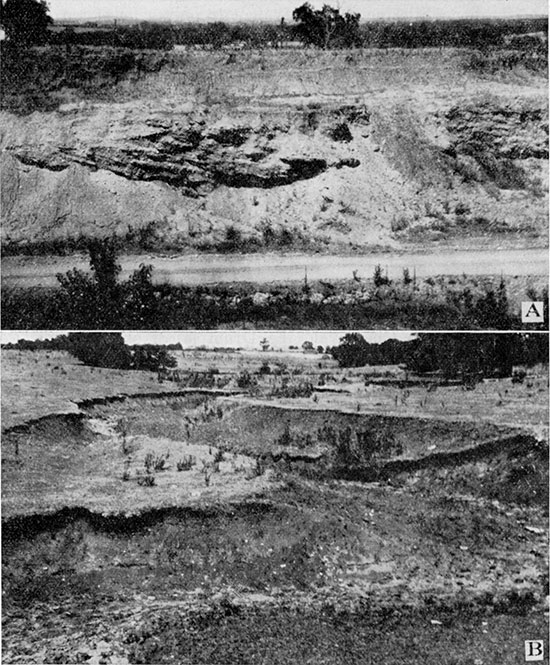
Plate V--A--High terrace gravel, near Holliday, Johnson County. B--Recent gully, middle south side sec. 22, T. 13 S., R. 24 E. Relief about five feet.
Although these local occurrences of limestones associated with the Drum indicate lack of uniform environment before and after deposition of the Cement City member, the member itself shows little irregularity. The greatest thickness occurs in township 18 south, range 22 east near Osawatomie, where the bed ranges from four to six feet. Generally, however, it averages about two and one half feet. The least thickness observed is one foot nine inches. This occurs about one fourth of a mile south of the NW cor. of sec. 7, T. 18 S., R. 25 E. The formation measures as little as two feet at many localities.
The Drum undergoes changes in thickness and lithologic character from north to south across Johnson County. Along Kansas river, Turkey creek, and part of the valley of Indian creek, in the northeast part of the county, the unit is characteristically light-gray to whitish in color. It is thin-bedded and wavy, with a massive layer at the top and the base. In this area the upper third contains scattered nodules of gray and brown chert. A thin layer of ferruginous or limy, granular, and locally cross-bedded limestone, possibly the Corbin City member, is in places seen above the main part, separated from it by a fossiliferous limy shale which is locally replete with Teguliferina armata. A persistent zone of Campophyllum torquium appears near the top of the main bed of the Drum throughout the northern part of Johnson County. This coral appears in no other formation in the county and consequently serves as a good horizon marker. Associated with this fossil in the limy shale at the top of the Drum is a faunule of bryozoans. In Johnson County the thickness of the formation is uniformly about ten feet. Toward the south it becomes massive, loses the cherty character and distinctive fossil zones. On Tomahawk creek the bed has a thickness of ten feet, is very massive, drab, weathers buff, and is rather unfossiliferous. Along Big Blue river it is markedly thinner. Here it measures about five feet and is a buff, somewhat ferruginous, and thin-bedded limestone. At this place a massive, gray layer occurs at the top.
Distribution. The Drum limestone crops out over a large part of Miami County, extending up Wea creek to the center of the north edge of sec. 32, T. 16 S., R. 34 E., and to sec. 35 of the same township along a westward-flowing tributary. Along Bull creek the formation crops out nearly to the center of T. 16 S., R. 23 E., and a reentrant occurs along the north edge of T. 16 S., R. 23 E., extending into Missouri at the north edge of sec. 14, T. 18 S., R. 25 E. On Marais des Cygnes and Pottawatomie rivers the formation extends nearly to the west line of range 22 east. In the valley of Mound creek the Drum crops out to a point southwest of Beagle.
The formation extends up Kansas river in Johnson County to the bend in the river at Bonner Springs, where it is fairly well exposed at the flood-plain level on the south side of the river. The formation extends a short distance up Mill creek and crops out in all of the valleys in the northeastern and eastern parts of the county.
Detailed sections. Sections of the Drum limestone are given in the register at the end of the report under numbers 1, 7, 8, 37, 38, 40, 41, 43, 48, 50, 52, 55, 59, 65, 66, 67, 68, 78, 81, 92, 94, 97, 98, 99, 101, 106, 109, 117, 129, 131, 132, 136, 139, 140, 141, 142, 147, 149, 150, 155, 156, 159, 160, 161.
Chanute Shale
The term Chanute was introduced by Haworth and Kirk for the thick shale underlying the town of Chanute in Neosho county, Kansas. [Haworth, E., and Kirk, M. Z., The Neosho river section: Kansas Univ. Quart., vol. 2. p. 109, 1894.] The formation as originally defined includes the interval between the Drum and Iola limestones. Because of miscorrelation of both the Drum and Iola limestones at Kansas City, the boundaries of the Chanute shale have been badly confused at that place. The present study has shown that the Cement City limestone of authors is the basal part of the Drum as originally defined, and the Raytown is part of the Iola; consequently the intervening shale is the equivalent of the typical Chanute.
Lithologic character and thickness. The Chanute shale, although somewhat irregular in Miami County, can be recognized easily in most places. Over a large part of the area of outcrop the formation contains a thin coal bed, which has a fairly uniform thickness, but occurs at different positions with respect to the formational boundaries. Where the formation is thin the coal occupies a higher position than otherwise, and the thinning seems to be chiefly the result of lensing out of the sandy layers above the coal. North of Osawatomie and at the north edge of Paola the coal is almost directly overlain by the Iola limestone. The coal bed ranges from about four to eight inches thick in Miami County. The part of the Chanute formation above the coal consists of buff sandstone and sandy shale. The part below the coal is composed of greenish, argillaceous shale with limestone nodules, and locally a layer of maroon shale. At some places the lower division is highly calcareous or slightly arenaceous, and in such cases is buff or greenish-buff. In a few instances a thin, nodular, argillaceous limestone overlies the maroon shale. In general the calcareous nodules are more abundant near the base. The term Thayer, which was a synonym of Chanute, is restricted to the persistent coal bed in the Chanute shale. For the upper sandstone mass the term Cottage Grove is here applied from a township in Allen county, Kansas. The coal bed has been traced as far south as Independence and it may extend farther. This is one of the beds that have long been mined near Chanute and Thayer.
The Cottage Grove sandstone at the top of the Chanute is generally soft, light-buff, and cross-bedded or even-bedded. The member ranges from less than a foot to thirty feet in thickness, being thinnest near Osawatomie and Paola where it wedges out northward. This sandstone thickens southward to a maximum near the county line southwest of Beagle. Locally an obscure coal streak occurs near the top, but this is not to be confused with the thicker persistent coal below. Apparently the sandstone is a deltaic deposit which was formed by sediments derived from the south.
The upper arenaceous part of the formation is about twenty feet thick in most places. The lower and more argillaceous part generally measures about twelve feet or so, although locally it increases to as much as sixteen feet. Where the formation is less than ten feet thick the coal bed is missing and the entire unit consists of greenish, argillaceous shale with calcareous nodules. Were it not for the even contact with the Iola above, one might conclude that the local thinning of the Chanute indicates an unconformity at the top. The formation ranges in thickness from eight and one half feet at the SE cor. of sec. 10, T. 17 S., R. 23 E., to thirty-eight feet in the southwest part of T. 17 S., R. 24 E. A peculiar feature is the distribution of the thinner development of the Chanute. A narrow band reaching from the northeast corner of township 17 south, range 23 east, extending through the northeast and southwest corners of township 19 south, range 22 east, includes an area where the Chanute is less than fifteen feet thick, and most commonly about ten feet thick. Elsewhere in the county the formation averages about thirty-two feet in thickness.
Although comparatively uniform in most of its characters in Johnson County, the Chanute increases in thickness toward the south. It ranges from about nineteen feet along Kansas river to more than thirty feet along Big Blue river. It is predominantly argillaceous, although an arenaceous shale or sandstone locally occurs near the middle. Of considerable interest is a layer of maroon shale near the base of the formation. This layer ranges in thickness from less than one foot to more than five feet, but it is commonly about two feet thick. It is underlain by a thin layer of olive-green, argillaceous shale, and is overlain commonly by a thin bed of marlite. [Hinds, Henry, and Greene, F. C., U. S. Geol. Survey, Geol. Atlas, Leavenworth-Smithville folio, p, 3, 1917.] The term marlite is applied to thin layers of yellowish-brown or greenish, nodular, and "spongy" rock that ranges from a ferruginous, argillaceous limestone to a calcareous shale. Beds of marlite commonly overlie some of the thin and persistent maroon shales in eastern Kansas.
Distribution. The outcrop of the Chanute shale in Miami County occurs in an area about the same as that of the overlying Iola limestone. On Bull creek the formation crops out to the northeast corner of township 16 south, range 22 east, and to Hillsdale. On Wea creek and its tributaries the bed extends a short distance beyond Somerset, follows Bull creek southward to Block and thence eastward around Middle creek to New Lancaster, and northeastward out of the county into Missouri in sec. 11, T. 18 S., R. 25 E. The outcrop of the formation enters the southern part of the county along Mound creek in sec. 16, T. 19 S., R. 22 E., and extends northeastward to about the middle of township 18 south, range 23 east. The outcrop extends up the Marais des Cygnes and Pottawatomie rivers to the west edge of range 22 east.
In Johnson County the Chanute extends up the valley of Kansas river nearly to the mouth of Cedar creek on the south side of the river, considerably farther than on the north side. All of the larger valleys in the northeastern and eastern parts of the county contain the outcrop of the Chanute.
Detailed sections. Sections of the Chanute shale are given under localities 7, 8, 37, 38, 39, 40, 41, 50, 52, 55, 58, 67, 68, 78, 79, 80, 81, 92, 93, 94, 96, 97, 98, 99, 100, 106, 108, 109, 111, 117, 118, 129, 131, 132, 135, 136, 137, 139, 140, 141, 142, 147, 149, 150, 156, 161, and 162.
Iola Limestone
The Iola limestone formation was named by Haworth and Kirk from exposures at Iola, Allen county, Kansas. [Haworth, E., and Kirk, M. Z., The Neosho river section: Kansas Univ. Quart., vol. 2, p. 109, 1894.]
Since the early days of geological work in Kansas, there has been a general misunderstanding regarding the Iola limestone and associated formations in northeastern Kansas. Because of excellent exposures of rocks and accessibility the Kansas City area has been visited by many geologists, and the classic section exposed at this place has become the standard section for many units within the Missouri series. Through the work of pioneer investigators, principally that of Bennett, the early Kansas Survey correlated various of the beds exposed at Kansas City with units named from localities in southeastern Kansas a hundred or so miles away. The correlations were made on lithologic similarity, sequence, and presumably by tracing the outcrops in the field.
In the present investigation the so-called Iola limestone (Frisbie-Argentine) was traced southwestward from Kansas City. The limestone was found to pinch out in the vicinity of Greeley, Anderson County, Kansas, therefore not reaching the type locality of the Iola limestone. On tracing the typical Iola limestone northward from Iola, where it is a thick, prominent unit, I found that the main upper part of the formation is continuous with the Raytown limestone of Hinds and Greene. [Hinds, Henry, and Greene, F. C., The stratigraphy of the Pennsylvanian series in Missouri: Missouri Bur. Geology and Mines, vol. 13, 2d ser., p. 27, 1915.] The correlation of Raytown with the upper part of typical Iola limestone was confirmed in the field by Doctors R. C. Moore and John L. Rich.
In the Kansas City area the Raytown is underlain by one to three feet of shale containing a black, fissile layer. Above the carbonaceous layer occurs a few inches of argillaceous shale bearing small phosphatic concretions having a diameter of one half inch to one inch or more. Below the shale is a thin blocky bed of bluish-gray dense to lithographic limestone a foot or less thick. This limestone is characterized by abundant laminated Cryptozoon-like structures. Through careful tracing it was discovered that the thin blocky limestone is the basal layer of the typical Iola and therefore the black shale is included in the Iola formation. Because the three divisions of the formation have been recognized throughout almost all of the outcrop in eastern Kansas and adjoining parts of Missouri, I propose to name the basal bed Paola limestone, from the town Paola in Miami County, and the middle shale the Muncie Creek, after a stream in southern Wyandotte County east of the town Muncie. As originally defined the Raytown consists of a single massive layer of dark-gray and buff limestone.
The Iola limestone, especially in the Kansas City region, displays in part the cyclic sequence so typical of the Shawnee limestone formations. The blocky, dense limestone at the base has all of the lithologic characters of a "middle" limestone of such formations as Oread or Deer Creek. The black, fissile layer of the Muncie Creek, as in the Oread or Deer Creek, lies upon dense, blue, blocky limestone. The Raytown limestone is similar to those members of the Ore ad or Deer Creek which overlie black fissile shale. Locally at the top of the Raytown, as for example at Iola, Kansas, there is a layer of algal limestone containing mollusks. Again this feature has its homologue in the Shawnee formations, where the uppermost limestone, as for example the Kereford member of the Oread limestone, contains algal limestone and remains of mollusks.
Lithologic character and thickness. The black, carbonaceous shale of the Muncie Creek member thins out southward from the northeast corner of Johnson County, and a six-inch bed of gray or buff clay containing spherical phosphatic nodules remains, separating the upper limestone from the lower. I have traced the Iola continuously from Wyandotte County to Mildred, Allen county, Kansas, and thence to Iola. Throughout this wide area the thin Muncie Creek clay with black phosphatic concretions occurs about two feet from the base. The Paola limestone below the shale parting is always darker and more dense than the limestone above. It generally weathers as a single massive layer, whereas the limestone above the shale weathers in irregular thin layers.
In Johnson County the Raytown member is composed of fairly even-bedded, rather massive, gray limestone. This member is generally fossiliferous and is characterized by numerous large productids, especially Echinoconchus semipunctatus and Linoproductus spp. The species Spirifer dunbari is usually abundant and robust at this horizon. The upper part of the limestone becomes brown and is broken down into small angular fragments as a result of prolonged weathering. Fresh exposures of the rock show a very fine-grained and "sugary" texture. The Raytown is about five feet thick throughout Johnson County.
The thin Muncie Creek shale separating the upper and lower Iola members is generally buff or gray and argillaceous. Invariably it contains more or less abundant phosphatic concretions which are small (one half to one inch in diameter) and spherical or ellipsoidal. Weathering changes the black color of the concretions to white or light gray, but the interior remains black or dark gray. The shale ranges from about four to eight inches in thickness in Johnson County.
The Paola limestone is composed of a single layer of very dense, dark, bluish-gray limestone. The rock is very brittle and weathers in angular blocks. The upper surface of the bed is highly irregular and pitted, and generally contains openings to iron-stained tubes which extend a short distance into the rock. This layer is always characterized by the coils and stringers of banded calcite which resemble forms of calcareous algae. The Paola is uniformly one and one half feet thick.
In Miami County the Iola is the most distinctive and one of the most easily traced formations. In the northeastern part of the county and as far south as Paola the formation is in no respects different from the Iola in southeastern Johnson County, but south and west of Paola it thickens uniformly. West of Bull creek the recognition of the Iola is made much easier by the great thickening of the Lane shale, giving the Iola limestone and the Wyandotte limestone above a good topographic expression and separating their outcrops more widely. From Osawatomie or Lane, the formation can be traced southward easily to Mildred and Iola, the outcrop lying east of the prominent Wyandotte and Plattsburg escarpments.
In Miami County, as in Johnson County, the formation consists of three parts: (1) an upper, thick, even-bedded unit, the Raytown, composed of more or less fossiliferous, buff or whitish, fine-grained limestone, (2) a thin gray shale, the Muncie Creek, containing phosphatic nodules, and at the bottom (3) a massive even layer of brittle, blocky, dense, and dark-gray or bluish limestone, the Paola. In the northeastern part of the county the Raytown is typically a thick-bedded gray or buff limestone with a thickness of about six feet. Near the middle there generally occurs a zone of large productids, the same as that which has caused the ledge to be called the "large fossil" bed at Kansas City. Toward the south the Raytown becomes more thinly bedded until at Paola the layers are about six inches thick. In the vicinity of Osawatomie and farther south the member becomes even more thinly bedded.
Throughout the northern half of the county the thin Muncie Creek shale with the phosphatic nodules is about five inches thick and the lower blocky Paola limestone measures about one and one half feet. This lower bed has certain characters which are remarkably persistent and easily recognized. Typically the limestone is bluish-gray, and at the top dense, becoming fine-grained in the lower half. The bed is very brittle, commonly weathers light gray, and breaks into angular blocks. The upper portion contains an abundance of the borings of annelids or some other organism. These are irregular tubes about a quarter of an inch or so in diameter and may be as much as six inches long. They are generally hollow and coated with iron stain, and communicate with the upper surface of the bed. This surface has peculiar low rounded irregularties consisting of pits and knobs, which suggest the term "hummocky." Associated with the lithographic texture occur numerous irregular banded "marklets" of calcite. These are possibly the remains of calcareous algae. Southward from Osawatomie the Paola limestone becomes less distinctive, loses the lithographic texture and weathers into thin plates. The color is dark gray and the algae and "worm-borings" are less obvious. The most constant part of the formation is the thin Muncie Creek shale with its phosphatic nodules. The southward increase in thickness of the Iola takes place mainly by thickening of the Raytown limestone. South of the Marais des Cygnes this member becomes whitish, crystalline, and thin bedded. The most abundant fossil is a species of Marginifera. North of Marais des Cygnes river the Iola measures from eight to ten feet, but at the west edge of township 16 south, range 23 east it is thirteen feet thick. South of this river the formation is thicker, becoming fourteen and one half feet thick in township 18 south, range 21 east. At Osawatomie and westward a sponge resembling Heierocoelia beedei makes its appearance in the base of the Iola and is locally fairly common.
Distribution. The Iola limestone has an extensive outcrop in Miami County. The outcrop enters the southwestern part of the county in sec. 16, T. 19 S., R. 22 E., and extends into township 18 south and range 23 east in the drainage area of Mound creek, thence following the valley of Pottawatomie creek westward a short distance out of the county. On the Marais des Cygnes the formation dips beneath the flood plain southeast of Stanton, but appears in the river channel at the bridge near the county line. On Bull creek and its tributaries the formation crops out to sec. 2, T. 16 S., R. 22 E., and to a point just northeast of Hillsdale. On the Wea creek drainage it extends to a locality just above Somerset. A small reentrant of Iola enters the county along the creek in township 16 south, range 25 east. From the valley of Marais des Cygnes river the outcrop extends eastward from Block across the northern part of township 18 south around the Middle creek and Sugar creek drainage, passing out of the county in sec. 11, T. 18 S., R. 25 E.
In Johnson County the Iola extends as far up Kansas river as the east shore of the mouth of Cedar creek. It is well exposed as an inlier along an anticline far up the valley of Cedar creek to a point a short distance northwest of Olathe. The Iola is well exposed along Mill creek, Turkey creek and along all the principal streams in the eastern part of the county.
Detailed sections. Sections of the Iola are given under numbers 7, 8, 14, 18, 19, 33, 34, 37, 39, 40, 50, 52, 55, 58, 59, 78, 79, 80, 88, 92, 93, 94, 95, 96, 97, 98, 99, 100, 106, 107, 108, 109, 110, 111, 118, 133, 135, 136, 137, 139, 141, 142, 147, 148, 149, 151, 156, and 162 at the end of the report.
Lane Shale
The thick shale bed lying between the Iola limestone and the so-called †Allen limestone at the town of Lane, Franklin county, was termed the Lane shale by Haworth. [Haworth, E., The stratigraphy of the Kansas Coal Measures: Kansas Univ. Quart., vol. 3, p. 277, 1895.]
The Lane shale was erroneously supposed by the early workers in northeastern Kansas to occupy that interval between the Iola limestone and the Allen, or lower Garnett limestone above (Plattsburg) . Haworth applied the name Lane to 100 feet of sandy shale between two prominent limestones near the town of Lane. The lower limestone, near flood-plain level, I have found was correctly identified by Haworth as Iola. The upper limestone, capping the scarp at Lane, is not, however, the Allen (Plattsburg limestone) as Haworth thought, but is a third limestone lying between the Iola and Plattsburg. This limestone, the Wyandotte of this report, although very prominent around Lane and northward to Kansas City and beyond, pinches out near Greeley in northeastern Anderson County. It is clear from the writings of the early workers that only two limestone formations were recognized in the section immediately succeeding the Lane shale, whereas there are three in northeastern Kansas.
The shale formation at Iola that is generally called Lane includes strata between the Iola and Plattsburg limestones and comprises equivalents of the type Lane shale, Wyandotte limestone, and Bonner Springs shale of this report. Adams once applied the geographic name Concreto, from a locality in the outskirts of Iola, to this shale. [Adams, G. I., Economic geology of the Iola quadrangle, Kansas: U. S. Geol. Survey, Bull. 238, p. 20, 1904.] This name is not synonymous with Lane, as has been supposed by other writers, and may properly be used for beds between the top of the Iola and the base of the Plattsburg. It seems preferable, however, to indicate the combined Lane and Bonner Springs shales. by the hyphenated term Lane-Bonner Springs shale, thus avoiding the necessity of using a geographic name that gives no indication of its stratigraphic relation to correlative units. Furthermore, if the practice is adopted of using a different name for every combination of shale units that is encountered through local disappearance of limestones, an almost endless number of new names with only local application would be required.
The shale bed at Kansas City, called the upper Chanute shale by Hinds and Greene, is the exact equivalent of the Lane shale. [Hinds, Henry, and Greene, F. C., The stratigraphy of the Pennsylvanian series in Missouri: Missouri Bur. Geology and Mines, vol. 13, 2d ser., p. 407, 1915.]
Lithologic character and thickness. The Lane shale undergoes considerable change in thickness and character from the east to the west half of Miami County. In the eastern part of the county the formation is a gray or buff argillaceous shale about twenty feet in thickness. Westward, across almost the mid-line of the county, the shale increases to about five times this thickness and assumes a dominantly arenaceous character. The thick sandy shale contains carbonaceous streaks, which, however, are not distinct coal beds. At Paola the formation is a little less than 100 feet thick, but a mile east of town at the SE cor. of sec. 10, it has decreased to thirty-three feet. In many exposures of the formation near the southeast corner of township 17 south, range 23 east, the thickness is twenty feet and reaches the minimum of 16 feet at the NE cor. sec. 2, T. 18 S., R. 23 E. On the other hand, the increase westward from Paola is not so abrupt. The formation measures 105 feet a mile west of Paola, about one fourth of a mile west of the NE cor. sec. 19, T. 17 S., R. 23 E., and does not vary as much as ten feet from this thickness at any observed exposure in the southwestern part of the county. A line drawn from the west edge of Paola north across the county seems to approximate the 100-foot thickness contour, the formation measuring more than this to the west of the line and less to the east of it. At Paola the unit is argillaceous and is used for making brick. To the west the formation is more arenaceous, especially in the vicinity of Stanton, where the upper part of the formation has many thin layers of soft, buff sandstone. At the top there is generally a zone of sandy, argillaceous, gray shale containing thin flakes of limy, ferruginous shale, giving a peculiar banded effect, the gray being broken by thin knife-edges of brown. Where the Lane shale is thin it has no special characteristics other than the homogeneity of the clay shale and the gray or buff color. Seldom is the shale arenaceous where it is less than thirty feet thick.
In Johnson County the Lane consists of uniform argillaceous, bluish-gray and buff shales more arenaceous toward the south. This formation, which has yielded such a prolific fauna of crinoids at Kansas City, is seemingly barren of invertebrates in Johnson County. Toward the southern part of the county a small amount of fragmental plant material occurs in the Lane. The formation is somewhat irregular in thickness, ranging from seventeen feet in township 14 south, range 24 east to over forty feet in the central and northeastern parts of the county.
Distribution. In the western part of Miami County, where the formation is thick, the band of outcrop is fairly broad, being two or three miles in places, terminating in a high and pronounced eastward-facing escarpment capped by the Wyandotte limestone. In the southwest corner of the county the formation enters on, the divide between Pottawatomie creek and Mound creek. Also a small tongue of the outcrop extends into the county between Pottawatomie creek and Marais des Cygnes river. North of the Marais des Cygnes the outcrop enters the county west of Stanton, follows the valley to Paola and extends up the valley of Bull creek almost to the northwest corner of the county and to the western edge of township 15 south, range 24 east. On the Wea and its tributaries the outcrop reaches to the northeast corner of township 16 south, range 24 east, and to a point southeast of Louisburg, extending well up all but the smallest streams. The outcrop follows a sinuous course across the southern part of township 17 south, ranges 24 and 25 east, and then bends northward, following the state line to the northeast corner of the county and leaving the county nearly precisely at the corner.
The Lane shale has a wide outcrop in Johnson County. It extends up the valley of Kansas river nearly to Cedar Junction, dipping below the flood plain at the west side of the valley of Cedar creek. There is a small inlier of the Lane a short distance above the mouth of Kill creek, exposed by a structural "high." The Lane extends up Mill creek to the northeast part of township 13 south, range 23 E, and enters the county again along Turkey creek. The formation is exposed along all of the principal tributaries in the eastern part of the county.
Detailed sections. Sections of the Lane shale are given under localities 14, 16, 18, 19, 33, 34, 37, 42, 77, 84, 87, 88, 95, 98, 102, 104, no, 112, 119, 135, 137, 138, 141, 142, 143, 144, 145, 146, 147, 148, 151, 164.
Wyandotte Limestone
As a result of the miscorrelation by the early Kansas Survey of the Iola limestone with certain beds exposed in the bluffs at Kansas City, several of the adjacent units, both below and above; were also miscorrelated. The shaly beds and limestones between the so-called Drum limestone at Kansas City and the prominent limestone above, thought to be Iola, were classed as Chanute shale regardless of the complete lack of lithologic similarity between these beds and the typical Chanute shale of southeastern Kansas. Because the Lane shale was supposed to lie between the Iola and Plattsburg limestones, all strata lying between the so-called Iola and Plattsburg limestones at Kansas City were classed as Lane shale.
For some reason, not now apparent, the pioneer geologists in attempting to trace and map the Iola limestone northward toward Kansas City from the type locality were confused in the neighborhood of Osawatomie and Paola in Miami County and changed from the typical Iola to the next higher limestone. This confusion which led to mistaking a younger limestone with the true Iola occurred at about the place where the Iola and Lane thin appreciably. The topographic expression of these units northward from central Miami County is less prominent than to the southward. Northward the limestone overlying the Lane shale splits into four limestones separated. by thin shales across Johnson and Wyandotte counties and into Missouri. The lower two limestones and included shale, locally missing, were classed by Kansas and Missouri geologists as Iola limestone. The upper two limestones and included shale bed, likewise locally absent, were called Farley limestone by Hinds and Greene from a hamlet in Platte county, Missouri. [Hinds, Henry, and Greene, F. C., The stratigraphy of the Pennsylvanian series in Missouri: Missouri Bur. Geology and Mines, vol. 13, 2d ser., p. 29, 1915.] These limestones were thought to lie within the Lane shale because of their place between the "Iola" and the Plattsburg.
It seems consistent to regard these closely associated limestones in the section between the Iola and Plattsburg limestones as a formational unit correlative with Drum, Iola, Plattsburg, Stanton, etc. There are two reasons why such a procedure seems logical. In the first place the limestone is an indivisible unit across Miami and Franklin counties. There are no shale partings, nor is there other basis, either lithologic or faunal, for a recognition of subdivisions. Secondly, in the area northeast of Miami County where the shale beds appear the limestone divisions exhibit the curious succession shown by many of the other limestone formations in the Missouri series. At the base there is a thin, blocky, bluish-gray limestone similar to the basal member of the Swope, Dennis, Iola, or Stanton limestone formations. Next is a thin shale which is locally carbonaceous at the base, corresponding to the second member, carbonaceous shale, of the Swope, Dennis, Iola, and Stanton formations. Thirdly, ascending in the column, there is a relatively thick, twenty to thirty feet, unit of thin-bedded, wavy, and cherty limestone similar to that of the main limestone member of the Swope, Dennis, Iola, and Stanton limestones. The upper limestone, commonly in two parts and separated from those below by shale, is like the upper limestone layers of the aforementioned limestone formations in being locally oolitic and at such places bearing a molluscan fauna. Because no other name has been suggested for the limestone formation in the interval between the Iola and Plattsburg limestones, I propose to apply to it the name Wyandotte, from the county of that name in northeastern Kansas. The five subdivisions, three of limestone and two of shale, are recognizable throughout northeastern Kansas north of Miami County and far into northwestern Missouri.
The lower blocky limestone, one to three feet thick, is called the Frisbie limestone, from Frisbie, Johnson County, Kansas. It is exposed at the middle of the north side of sec. 17, T. 12 S., R. 23 E. This unit is recognizable farther into northwest Missourri and farther southward into Miami County, Kansas, than any other member of the Wyandotte formation. [Hinds, Henry, and Greene, F. C., The stratigraphy of the Pennsylvanian series in Missouri: Missouri Bur. Geology and Mines, vol. 13, 2d ser., p. 119, 1915.] The next unit above the Frisbie, a thin argillaceous, limy, or carbonaceous shale is called the Quindaro shale, from a political township in Wyandotte County, Kansas. It is typically shown in the floor of Boyn's quarry, near the northwest cor. sec. 30, T. 10 S., R. 25 E. The next member constitutes the main part of the so-called "Iola" limestone of Missouri and northeast Kansas. This limestone, twenty to thirty feet thick, is named the Argentine limestone, from Argentine railway station, Kansas City, Kan. An exposure in a quarry south of Twenty-sixth and Metropolitan avenue may be considered the type exposure. The shale above the Argentine limestone is commonly less than eight or ten feet thick and is argillaceous or limy. It receives its name from Island creek in northern Wyandotte County. The member is typically exposed west and south of Wolcott. The upper member, with a thin included shale, was named Farley limestone by Hinds and Greene, the name being derived from a hamlet in Platte county, Missouri. [Hinds, Henry, and Greene, F. C., The stratigraphy of the Pennsylvanian series in Missouri: Missouri Bur. Geology and Mines, vol. 13, 2d ser., p. 29, 1915.] Southward from Johnson County the Farley limestone coalesces with the Argentine limestone to form an indivisible unit, which finally disappears near Greeley, in Anderson County.
In the vicinity of Stanton in western Miami County the Wyandotte limestone contains the brachiopod Enteletes, and southward beyond Lane this fossil is abundant in the formation. Apparently this brachiopod did not live in the Argentine sea farther north than the Stanton region, but it occurs sparingly in the Farley limestone in Johnson County. The top of the Argentine limestone ("Iola") was selected by Hinds and Greene as the upper limit of the original Kansas City formation. [Hinds, Henry, and Greene, F. C., The stratigraphy of the Pennsylvanian series in Missouri: Missouri Bur. Geology and Mines, vol. 13, 2d ser., p. 7, 1915.] It was claimed that the beds above and below this boundary were lithologically and faunally distinct. The brachiopod genus Enteletes was supposed to be specially diagnostic of horizons above the Argentine and had never been cited from lower beds in Kansas or Missouri. Enteletes is common in the Wyandotte beds from bottom to top in Miami and Franklin counties, but does not occur farther north except for the rare occurrence in the Farley limestone, mentioned above. Because the upper limit of the Argentine limestone can not be distinguished in Miami County and southward, where the Argentine and Farley come together, there is no lithologic basis for recognition of the boundary of the original Kansas City and Lansing formations.
Lithologic character and thickness. The Wyandotte limestone is generally quite easily identified in Miami County, but it is in some respects highly irregular. Commonly the formation is composed of light-gray or whitish, wavy and thin-bedded limestone, fine-grained and brittle. Locally the formation is very cherty, crystalline, and may have a blocky oolitic or Osagia limestone layer at the base. In the central part of Miami County and near the middle of the western boundary the formation is ferruginous near the middle and weathers in thin, platy fragments. At many localities it is stained buff or brown by the ferruginous partings at the bedding planes. In township 15 south, ranges 23, 24, and 25 east a thin shale parting occurs locally above the middle, probably a southward continuation of the Island Creek shale from Johnson County. South of Louisburg the formation has a basal layer of fine-grained bluish limestone, the Frisbie, separated from the main ledge by a few feet of limy shale. The shale at this place contains a small fauna of sponges. In the eastern part of the county the formation is generally very cherty, and it is interesting to note that in this same area the Plattsburg limestone is also cherty. Throughout the remainder of the outcrop of the Wyandotte in the county it has only a small amount of chert in the form of nodules. In township 17 south, ranges 21, 22 east the formation simulates the Plattsburg in having a basal oolitic bed. This lower bed, however, unlike the lower part of the Plattsburg, rarely contains fossils of any kind, and the remainder of the formation is distinctive. In the southwest corner of the county the formation thickens and becomes more evenly bedded and massive.
Of great interest are certain faunal characteristics of the Wyandotte in Miami County. Fusulinids, which are rare or absent from the formation in Johnson County, and entirely lacking in Wyandotte and in Jackson county, Missouri, make their appearance in considerable abundance in the northeastern part of Miami County. The guide fossils Enteletes hemiplicatus var. plattsburgensis and E. pugnoides make their appearance in the formation just west of Paola and a short distance north of Stanton. [Newell, N. D., New Schizophoriidae and a trilobite from the Kansas Pennsylvanian: Jour. Paleontology, vol. 5, pp. 260-269, 1931.] Toward the southwest part of the county Enteletes hemiplicatus var. plattsburgensis becomes abundant and is the most common fossil in the Wyandotte at Lane, in Franklin county. It is rather remarkable that elsewhere in the county the species is unknown below the Plattsburg limestone, although a careful search was made for it. The single known occurrence of Enteletes hemiplicatus var. plattsburgensis from the Farely limestone in the northeast part of Johnson County is of interest in this connection.
In Miami County the Wyandotte formation ranges in thickness from about twelve feet to over thirty feet. At localities in township 15 south, range 22 east, and township 17 south, range 22 east a minimum thickness of twelve feet occurs. In general, the formation is not greater than fifteen feet thick throughout the northwest part of the county. In township 15 south, range 23 east the formation thickens to the eastward and a thin shale parting divides the limestone in two parts. This is the southward continuation of the Island Creek shale that occupies a place in the formation to the north. The scarcity of good exposures in this part of the county prevents locating accurately the most southern extension of the shale. The wedging out of the shale, however, takes place three or four miles north of Louisburg, since the member is gone at that town and occurs at the south edge of township 15 south, range 25 east. In the last-mentioned area the upper part of the Wyandotte, the Farley member, is fifteen feet thick, thin-bedded, and composed of whitish and buff limestone. At the base of the Farley there is a thin stratum of oolitic limestone, beneath which lies five inches of argillaceous shale. The upper layer of the Argentine is also oolitic, while the remainder of the member is even, heavy-bedded, and cherty. In the northeast part of the county, north of Louisburg the Wyandotte ranges from twenty to thirty feet in thickness, thinning toward the south so that south of Louisburg the limestone is generally a little less than twenty feet thick.
In Johnson County the Frisbie limestone occurs at the base of the Wyandotte formation as a single layer of fine-grained, bluish-gray even limestone. It ranges in thickness between about one and five feet, but is generally about two feet thick. Fine exposures of this member may be seen at the localities described at the end of the report under sections 16, 19, 21, and 53.
Above the Frisbie in Johnson County occurs a thin layer of greenish, argillaceous, or buff, calcareous shale, the Quindaro. Locally, as at the exposures on Cedar creek west of Olathe, there occurs a thin layer of carbonaceous shale at the base of the Quindaro. Generally the shale ranges between one and six feet in thickness.
The Argentine limestone member is somewhat irregular in thickness and lithologic character in Johnson County. In the northern part, along Kansas river, Cedar creek, and Mill creek, the member is composed of whitish, hard, cherty and thin-bedded limestone, except at the top where it is commonly rather massive. In weathered exposures the lower portion has a tendency to be worn back farther than the upper ledge, the latter locally making bold benches and steep rocky bluffs. The upper layer of the Argentine is generally oolitic or granular, and bears a molluscan fauna. In places this bed contains an abundance of Myalina ampla. Silicified specimens of Fistulipora sp. locally occur associated with Myalina. The bedding of the members is characteristically wavy and irregular.
The overlying Farley limestone might in many places be easily mistaken for the Argentine. The two members are separated by the Island Creek shale ranging from a foot to fifteen feet in thickness, which thins gradually toward the south and southwest. In the southwest part of the county, where the Argentine and Farley limestones are indistinguishable, the entire interval of limestone is cherty, thin-bedded, and wavy, composed of white, hard limestone, which is generally stained yellowish-brown by numerous thin, ferruginous shaly partings.
In the southeast part of Johnson County the lower massive Frisbie commonly is not separated from the Argentine by a shale parting, and is not as distinctive as it is elsewhere. The Farley limestone is only locally cherty, and is generally more abundantly veined and crystalline than the Argentine. Ordinarily it is thinner than the latter and displays a fragmental or pseudo brecciated appearance. The most positive identification of these two units, as a rule, is based on a recognition of the local stratigraphic sequence. The beds above and below these two limestones can usually be recognized easily.
In the northern and central parts of the county, the Argentine generally has a thickness of twenty-five to twenty-eight feet. In township 14 south, range 25 east it is quite thick, measuring over thirty-five feet in several places along Big Blue river. In this area the Argentine and Farley limestones, separated by a thin shale, make an unusually thick limestone section, measuring as much as sixty feet. In the southwest part of the county the single unit composed of the combined limestone members of the Wyandotte is little more than twenty feet thick.
The Island Creek member throughout Johnson County is quite thin, and uniform in its characters. The shale is generally argillaceous where thickest and is bluish-gray or buff. Where it is thin it is fossiliferous, and in many localities limy. The member ranges in thickness from six to fifteen feet in the northeastern part of the county, and thins to little over a foot toward the south. In the exposures along the upper part of Kill creek and Cedar creek, the unit is generally about two feet thick. It is noteworthy that locally this member contains great numbers of well-preserved fenestrated bryozoans and other invertebrates.
The characters of the Farley limestone are constant over most of the county. The member is, however, irregular in township 12 south, range 23, 24, and 25 east, where it consists of two thin, massive beds of limestone and a thin bed of shale, and in the vicinity of De Soto where variable cross-bedded, irregular limestones make up a considerable part of the member.
In the northeastern part of the county the Farley consists of three beds, two of limestone and one of shale. The lower of these is a massive, bluish-gray limestone, which commonly weathers buff. At the center of sec. 7, T. 12 S., R. 24 E., the thickness is about six feet. The bed is five feet thick at at the NW cor, sec. 10, T. 12 S., R. 24 E., and is suboolitic, This represents an intermediate stage between the oolitic facies found in Wyandotte County and the nonoolitic condition characteristic of the bed in Johnson County. At the west side of sec. 17, T. 12 S., R. 24 E., the lower Farley consists of a two-foot bed of massive, dark, brittle limestone.
The middle of the three beds of the Farley in the northeastern part of the county consists of variable shale. At the center of sec. 7, T. 12 S., R. 24 E., the shale has a thickness of four feet, and is argillaceous. The bed at the NW cor. sec. 10, T. 12 S., R. 24 E., consists of greenish-buff, arenaceous and micaceous shale, with a layer of limonite concretions near the middle. Here the bed is ten feet thick. At a locality on Little Mill creek the shale has the same thickness, but peculiarly contains a thin streak of maroon shale near the middle, overlain by a thin marly layer which in turn is overlain by greenish, argillaceous shale. The occurrence in a small area of the sequence in ascending order of green clay, maroon clay, "marlite," and green clay, so persistent at other horizons, is unusual. To the west the middle Farley thins and finally disappears near the middle of township 12 south, range 23 east.
The upper Farley in the northeast corner of the county is a massive bed of dark-gray limestone, usually brittle, and weathers into thin, irregular plates. The bed has a considerable range in thickness over a distance of a few miles. A short distance southeast of Holliday it has a thickness of nearly ten feet. To the east and north of this locality, into Wyandotte County, the upper Farley thins and becomes uniform in thickness. Northwest of Shawnee it is two feet thick. At the west edge of sec. 17, T. 12 S., R. 24 E., the bed contains Enteletes hemiplicatus var. plattsburgensis. This is the lowest known occurrence of this fossil in Johnson County.
The Farley limestone underlies layers of limestone conglomerate and shell breccia in the vicinity of De Soto. It is probable that the conglomerate was derived by the erosion of the upper surface of the Farley bed to the north of Kansas river in the vicinity of Loring, and at De Soto west of Kill creek, since there is evidence of a post-Farley pre-Plattsburg unconformity at these places. The breccia and conglomerate are younger than the Farley.
At the quarry near Loring on the north bank of Kansas river the Bonner Springs shale is one foot thick. At De Soto and at a point a mile west of Bonner Springs at the county line, the Plattsburg limestone directly overlies thinly cross-bedded, oolitic and coquina-like limestone. Directly beneath this lies the Farley limestone. A line drawn on a map from the cement plant at Bonner Springs through Wilder, following the south and east bluff of the valley of Kansas river to the mouth of Kill creek, follows a course of moderate variation in thickness of the Bonner Springs shale. Along this line the Bonner Springs is thick, ranging from twenty-five to over thirty-five feet. The course of the river from Bonner Springs to Cedar Junction is at right angles to the direction of convergence of the Farley and Plattsburg limestones. It has been shown by Jewett and Newell that the peculiar course of Kansas river at this place is accordant with anomalies in the structure of the underlying rocks. [Jewett, J. M., and Newell, N. D., The geology of Wyandotte County, Kansas: This bulletin, p, 151.]
It seems probable that during Bonner Springs time slight warping with considerable vertical movement occurred in the area of De Soto, Lenape, and Bonner Springs, slightly to the west of the present course of the river. The amount of uplift was sufficient at least to bring the sea floor locally above wave base and permit the removal of the Bonner Springs shale, if it were ever deposited, and production of shallow water or. shoal gravels, contemporaneously with deposition of part of the Bonner Springs shale. By Plattsburg time deposition was once more continuous across the anticline.
Over the greater part of the area in which the Farley limestone crops out, including (1) the area covered by the headwaters of Kill creek and Cedar creek, (2) an area in township 13 south, ranges 22, 23 east, (3) that area drained by the upper half of Mill creek, and (4) the southern half of the county, the member consists of a single limestone bed with no included shale. In lithologic character and locally in thickness the Farley resembles closely the Argentine limestone. Generally the former is thinner, less cherty, more regularly bedded, less fossiliferous, and darker in color than the latter. The Farley commonly displays a fragmental or pseudo-brecciated character, together with an abundance of veinlets of dark calcite. Generally the layers are wavy, but have a fairly uniform thickness at any single exposure of the member. In general, however, the best method of distinguishing the Farley rests upon the recognition of the beds above and below it. At the fine exposures along Cedar creek, on the highway west of Olathe, the Farley is about twenty feet in thickness, and in the southeast part of the county it measures about the same. The great thickness of limestone in the latter area is largely produced by a local thickening of the Argentine. West of Spring Hill the Farley cannot be differentiated from the lower members of the Wyandotte, the divisions occurring as a single limestone unit with a thickness not greater than twenty-five feet.
Distribution. The Wyandotte limestone crops out widely in Miami County. In township 17 south, ranges 24 and 25 east, the formation occupies much of the high stream divides and is generally exposed along the tributaries in the northeast part of the county. The formation extends out of the county along all of the principal streams in the northern part of the county and occurs along the valley of Bull creek as far as Paola and up the valley of Marais des Cygnes beyond the county line. In the southwest part of the county the formation enters just east of the corner, extends around the head drainage of Mound creek and continues out of the county along Pottawatomie creek to the west. The outcrop of the Wyandotte limestone in Johnson County extends up the valley of Kansas river to De Soto. The formation outcrops far up Kill and Cedar creeks, and extends up Mill creek nearly to Olathe, and occurs in the river bluff as far east as Rosedale with a reentrant on Turkey creek extending beyond Merriam. In the eastern part of Johnson County the Wyandotte extends a considerable distance up all of the larger streams, and forms a marked bench in the valley walls. In the southwestern part it extends a short distance into the county along the major tributaries.
Detailed sections. For sections of the Wyandotte see numbers 3, 4, 5, 6, 9, 10, 11, 12, 13, 14, 16, 17, 18, 19, 21, 22, 24, 27, 29, 30, 31, 33, 34, 36, 37, 42, 46, 47, 49, 51, 53, 56, 62, 69, 71, 75, 77, 82, 83, 84, 85, 87, 88, 90, 91, 95, 102, 104, 110, 112, 113, 114, 119, 135, 137, 138, 139, 142, 143, 144, 145, 146, 147, 148, 151, 163, 164, 165 at the end of this report.
Bonner Springs Shale
The term Bonner Springs is here applied to the shale between the Farley and the Plattsburg limestones, generally referred to erroneously as the upper Lane shale. The name is derived from a town in Wyandotte County, and is typically exposed at the cement plant northeast of the town. Under the discussion of the Lane it was shown that the Lane shale is an older formation than the unit here called Bonner Springs.
Lithologic character and thickness. Although the Bonner Springs shale is rather irregular in its characters, usually it may be recognized easily. In Miami County a soft, buff sandstone layer ranging from five to ten feet or so in thickness generally occurs at the base. Locally, as at the NE corner of sec. 13, T. 17 S., R. 21 E., and at the SE corner of sec. 19, T. 15 S., R. 23 E., the sandstone is replaced by greenish and argillaceous shale; or, as at the SE corner of sec. 22, T. 15 S., R. 22 E., it is partly replaced by arenaceous shale. Above the arenaceous division there is commonly a bed of olive-green, argillaceous shale, ranging in thickness from approximately four to ten feet. This is succeeded, except south of township 18 south, by a thin layer of maroon clay, generally about a foot thick, but ranging from six inches to sixteen feet, the latter thickness being measured in the SE cor. of sec. 19, T. 15 S., R. 23 E. As a rule the maroon layer is not thicker than one and one half feet. This maroon shale is an extremely important key horizon if it is not confused with similar shales in formations lower in the section. Although the maroon layer is locally lacking, it is extraordinarily persistent from northwestern Missouri to the south boundary of township 18 south in Miami County. The southernmost known occurrence of the maroon layer of the Bonner Springs is one quarter of a mile north of the SW corner of sec. 32, T. 18 S., R. 22 E. Above the maroon bed there is commonly a thin layer of argillaceous nodular limestone or limy shale, generally stained ocher-yellow or greenish. For convenience this highly characteristic rock is called "marlite." The marlite is generally overlain by a six-foot layer of greenish argillaceous shale which locally contains small irregular limestone nodules. At a few places this bed is arenaceous and buff or gray.
The Bonner Springs is highly irregular in thickness in Miami County, ranging from five and one half to thirty-two feet. In Johnson County the formation is fairly uniform in lithologic character, but somewhat irregular in thickness.
Certain peculiarities make the Bonner Springs shale easily recognizable, except locally, wherever it crops out in the county. Although the different parts of the shale are somewhat irregular, the sequence of the parts is practically the same from place to place over a large area in Johnson County, being about the same as in Miami County. The lower half of the formation is generally buff, or greenish-buff, micaceous sandstone or arenaceeous shale. This part frequently contains plant fossils, but no marine shells, and ranges in thickness from five to fifteen feet. The upper part of this portion of the Bonner Springs grades into a more argillaceous, greenish shale which is overlain generally by a thin layer of maroon, argillaceous shale. The latter layer is in most places less than two feet thick. Locally the maroon shale may be absent. Above it is an almost equally persistent layer of marly, ocher or brown, nodular and often spongy limestone. Frequently this "marlite" has a tinge of green. Above the marlite layer generally occurs a bed of olive-green, highly argillaceous shale which ranges up to five feet in thickness. Occasionally this is overlain by a thin layer of limy and arenaceous buff or gray shale. The formation averages about 25 feet in thickness, but locally ranges from 0 to 45 feet. The greatest variation occurs in township 12 south, ranges 22 and 23 east, and in township 13 south, ranges 22 and 23 east. In township 14 south, range 24 east, the formation is quite thick, measuring about forty-five feet. In township 15 south, range 23 east the formation is only thirteen feet thick, while in township 15 south, range 22 east it approximates twenty-five feet. Locally in township 12 south, range 22 east the formation is missing, having been eroded before deposition of the Plattsburg.
At De Soto, exposed along the railroad tracks, the Plattsburg unconformably overlies the Wyandotte limestone, the Bonner Springs being entirely missing. A similar situation occurs a half mile west of Bonner Springs. At both localities there occurs a thin, cross-bedded, granular limestone between limestone of characteristic Farley lithology and the characteristic Merriam member of the Plattsburg.
The key to the difficult stratigraphy of the De Soto region seems to lie in the section at Penner's ford at the east bluff of Kill creek, 0.6 mile west of the NE corner of sec. 4, T. 13 S., R. 22 E. At this locality it is easily demonstrated that the sponge fauna of the De Soto region occurs in the Merriam member of the Plattsburg. The Merriam limestone is underlain by a five-foot bed of limestone and shell breccia containing a prolific and characteristic pelecypod fauna. At several localities in the De Soto region the Merriam is underlain by this shell breccia. The latter is also well developed at the exposure on the highway one half mile west of Bonner Springs.
Much confusion in identification of beds is introduced by the local thickening of the Hickory Creek shale member of the Plattsburg limestone from the characteristic thicknesss of a foot or so to twenty feet, as at the Kill creek bridge one half mile east of De Soto, on the highway. At the same locality the shale portion of the Bonner Springs is lacking, either from erosion or nondeposition, and the breccia bed of the Bonner Springs lies directly on the Farley.
Along the tracks at De Soto the Hickory Creek shale attains its common thickness of a few inches, and as at the above localities there is no shale in the Bonner Springs. The limestone exposure along the tracks at De Soto includes the Farley and Plattsburg, with the Argentine and Island Creek just below the level of the railroad. The section above the Plattsburg is normal.
Apparently the breccia in the Bonner Springs represents material, perhaps shoal gravels, derived from limestone older than the Bonner Springs formation. The absence locally of the Bonner Springs shale may have been caused either by nondeposition or by erosion.
At the large railroad quarry between Lenape and Loring, northeast of De Soto, the Bonner Springs shale is very thin and apparently contains no limestone.
Distribution. The Bonner Springs shale has a wide distribution in both Miami and Johnson counties. This can best be appreciated by reference to the areal maps. In Miami County the formation crops out along all of the principal streams in the western half and the northern half of the county. Exposures of the Bonner Springs shale may be found in Johnson County along Kansas river and its tributaries below De Soto and on the streams in the eastern part and southern part of the county.
Detailed sections. For sections of the Bonner Springs shale see localities 2, 3, 4, 5, 9, 10, 11, 13, 14, 15, 16, 17, 18, 19, 21, 22, 23, 24, 25, 26, 27, 29, 31, 35, 42, 47, 49, 53, 54, 56, 60, 62, 69, 70, 72, 74, 75, 77, 82, 83, 84, 85, 86, 88, 90, 91, 102, 103, 105, 113, 114, 115, 148, 165.
Lansing Group
The term Lansing was introduced by Hinds for strata between the top of the Argentine limestone of the present report and the top of the Stanton formation. [Hinds, Henry, Coal deposits of Missouri: Missouri Bur. Geol. and Mines, vol. 2, 2d ser., p. 7, 1912.]
The boundary between the Kansas City and Lansing divisions as originally defined cannot be recognized in Kansas south of Johnson County. In northeastern Johnson and south-central Wyandotte counties the middle shale of the Farley wedges out so that the Farley limestone becomes a single unit to the southward. The Island Creek shale below the Farley limestone thins southward across Johnson County, eventually wedging out completely in northern Miami County. Where the Farley coalesces with the "Iola," or Argentine limestone of this report, the old boundary between the Kansas City and Lansing groups cannot be recognized, either lithologically or faunally. The single limestone, Wyandotte, formed by the union of the Argentine and Farley members changes to shale in Anderson County, to reappear no more to the south.
On the evidence here presented, Moore proposes to redefine the term Lansing to include only the Plattsburg, Vilas, and Stanton formations. [Moore, R. C., Kansas Geol. Soc., Guidebook 6th Annual Field Conference, pp. 92, 93, 1932.] This usage corresponds to the old Garnett limestone of the early Kansas Survey. The revival of Garnett might not be desirable, however, inasmuch as the term has been used for several different units and has never had wide acceptance.
The grouping of the persistent and relatively uniform Plattsburg and Stanton formations sets them off from the less regular and generally less persistent units of the Kansas City group below.
Plattsburg Limestone
The Plattsburg formation was named by Broadhead 52 in 1862. [Broadhead, G. C., Coal measures in Missouri: St. Louis Acad. Sci., Trans., vol. 2, pp. 317-327, 1868 (read May 5, 1862).] The type locality is Plattsburg, Clinton county, Missouri. The early Kansas Survey, upon the advice of Bennett, correctly correlated the so-called lower Garnett limestone or Allen limestone with the previously named Plattsburg limestone of Missouri, but for some reason did not adopt Broadhead's term. The correlation was made by Bennetts from field studies in Leavenworth, Johnson, Wyandotte, and Miami counties. [Bennett, John, Kansas Univ. Geol. Survey, vol. 1, p, 71, 1896.]
The Plattsburg limestone is strikingly constant in its characters over a wide area in northeastern Kansas and adjacent parts of Missouri. Fossil zones occur at the same relative position in the formation, associated in each case with distinctive lithologic divisions.
The Plattsburg is readily divisible into three parts, a basal, thin, blocky limestone, a thin shale parting, and a relatively thick upper limestone. The lower member is here termed the Merriam limestone, from exposures at the town Merriam, in Johnson County. The middle shale is termed Hickory Creek, from a stream near Peoria in Franklin county. The upper and principal member is named from exposures at the town Spring Hill in southern Johnson County.
Lithologic character and thickness. The Plattsburg limestone is one of the most distinctive formations in the Missouri series. Through most of northwestern Missouri and northeastern Kansas the unit retains its characters with but little variation in lithologic character. The formation displays locally, however, a considerable range in thickness.
At the base is the Merriam member, which is perhaps the most characteristic part of the Plattsburg. Locally the member might be confused with the Paola limestone at the base of the Iola. Where the Plattsburg has undergone considerable weathering, as on hilltops, the lower member is frequently the only recognizable part of the formation.
The Merriam limestone consists in many places of two distinct divisions. The lower of these is a blocky, even layer, less commonly cross-bedded limestone, drab to light gray in color, which generally weathers gray to white. This division is often highly fossiliferous, in which case species of the Productidae are abundant. The small ellipsoidal alga Osagia is always present in sufficient quantities to constitute an appreciable part of the limestone. The large pelecypod Myalina ampla is characteristic and usually well-preserved as internal molds. A zone of Composita sp. in many localities occurs at the base. Locally the bed is oolitic. In some cases this lower layer is absent, especially in southern Miami County. This part of the Merriam ranges from a few inches to five feet or more in thickness, but it is commonly about eighteen inches thick. Locally in northeastern Johnson County the bed makes very good dimension stone.
The next stratum of the Merriam, in ascending order, is quite distinct from that described above. This limestone is fine-grained to dense, gray, massive, blocky, and occurs in one layer. It is seldom very fossiliferous, but typically contains in the upper part numerous, irregularly-disposed, hollow tubes. These tubes are cylindrical, have a diameter of a fourth of an inch and a length of two to four inches or more. To some extent they seem to be vertically directed, and in some cases open at the upper surface. Generally the walls of the tubes are stained yellowish-brown, and the tubes themselves are frequently filled with ferruginous clay. This layer closely resembles the Paola limestone, but is less dense, lighter in color, and seems to lack the profuse development of Cryptozoan-like structures so typical of the former. The upper bed of the Merriam is generally about a foot thick. In its physical characters the upper blocky, dense layer of the Merriam resembles a typical "middle" limestone of the limestone cycle in the Kansas Pennsylvanian, homologous to such beds as the middle Oread, Leavenworth member. Like the Leavenworth the Merriam underlies, at least locally, black fissile shale.
The upper and lower members of the Plattsburg are separated by a foot or so of shale, the Hickory Creek, which only locally is absent. In the northern part of Johnson County, and in Wyandotte County, the shale contains a black carbonaceous layer, but to the south it becomes gray or yellowish and argillaceous. In some instances, as at the south edge of sec. 29, T. 13 S., R. 23 E., the shale is overlain and underlain by a peculiar ochery, shaly limestone or calcareous shale. In such case, for convenience, the yellowish shaly layer is considered as the division between the upper and lower Plattsburg.
The upper limestone, or Spring Hill member, seems to be just as well differentiated into lithologic and faunal zones as the Merriam, but is seldom as accessible to study. The lower part of the member in most of Johnson County consists of thin-bedded and even, bluish-gray, brittle and fine-grained limestone. In fresh exposures this limestone locally is massive, and the bedding planes are marked by narrow carbonaceous streaks. This bed contains a zone of Enteletes hemiplicatus var. plattsburgensis, and in many places the brachiopod Marginifera wabashensis is quite abundant. This division of the Spring Hill averages about five feet in Johnson County, but is rarely over a foot or so thick in Miami County. A bed of oolitic limestone commonly occurs above it. The oolite is thickest in the southern part of Johnson County and is of variable thickness, but is generally about two feet. The upper part of the member is very massive, and is granular, drab, argillaceous, occasionally dove-colored, and commonly contains a large quantity of fragmental fossil material. The limestone contains an abundance of the spines of Echinocrinus spp. and a zone of Composita sp. in which is found a particularly large and robust variety. Locally and more particularly toward the southern part of Johnson County, a layer of dark-gray, granular limestone overlies the Composita zone. The thickness of the limestone above the oolitic stratum is about five feet.
It is clear that the Spring Hill member is a composite unit in terms of the limestone cycle. The lower half or less consists of even, gray limestone containing brachiopods and bryozoans. This part is lithologically like an "upper" limestone of the cycle, and like homologous units overlies, at least locally, black fissile shale. The remainder of the Spring Hill is oolitic or granular and contains a large molluscan element. Obviously this division is by position, lithologic character, and faunal content a typical "super" limestone of the limestone cycle. Like other limestone formations in the Missouri series, a "lower" limestone of the cycle appears to be lacking.
The thickness of the Plattsburg limestone has a considerable range in both Johnson and Miami counties. In this respect it is more irregular than might be expected. The greatest thickness occurs in the vicinity of De Soto, where the formation is twentyeight feet thick. Here it resembles the exposure of the Plattsburg at the Loring quarry in Leavenworth county. At Holliday the Plattsburg approximates sixteen feet, and northwest of Shawnee ten and one half feet. The thinnest development of the formation in Johnson County seems to be along Little Mill creek in township 12 south, range 24 east, where a thickness of nine feet and less was measured. The Plattsburg is fifteen feet thick along Mill creek in sec. 13, T. 13 S., R. 23 E.; eleven feet at the head of Cedar creek, T. 13 S., R. 23 E., nine feet at the NW cor. of sec. 22, T. 13 S., R. 22 E., and twelve feet thick in T. 15 S., Rs. 22-23 E. Near Frisbie, in T. 12 S., R. 23 E., the Plattsburg is eleven feet thick. Just east of Prairie Center the formation seems to be uncommonly thick, although the measured thickness of twenty feet may be too great, due to slumpage. The local variation in thickness is likewise considerable in Miami County. The thinnest development observed in the county was ten feet in the NW, of sec. 5, T. 16 S., R. 22 E. The thickest Plattsburg section was found at the middle of the west edge of sec. 31, T. 15 S., R. 23 E. Commonly a thickness of eleven or twelve feet is encountered.
In the study of Miami County stratigraphy information was obtained that throws new light on certain correlations made by the early Kansas Survey. In the description of the Stanton limestone, Swallows! made the often-quoted statement: "This limestone is well exposed in the eastern bluff of the Marais des Cygnes; in the highest points north of the 'Devil's Backbone' above Stanton." [Swallow, G. C., Geological report of Miami County, Kansas: Kansas Geol. Survey, p. 75, 1865.] Swallow called the formation which makes the "Devil's Backbone" and upon which the town of Stanton is built the Cave Rock. In his generalized section of Miami County Swallow represented the Stanton limestone as the first limestone above the Cave Rock formation.
Until the present study it has not been realized that there are three limestone formations above the Iola in the vicinity of the towns of Stanton and Lane. The Cave Rock of Swallow, as described in the Stanton region, is the Wyandotte of the present report, and his Stanton limestone is beyond any question the Plattsburg of the modern classification. That Swallow realized the existence of a limestone immediately above his Stanton is clearly shown in his generalized section of Miami County.
Because of established usage, however, the present misapplication of the term Stanton should not be stressed. Broadhead's term Plattsburg was first published in the same year as Swallow's Stanton. The terms Stanton and Plattsburg are both securely established in geological literature and there has never been any serious question as to their usage. Therefore, in spite of the availability of Adams' term Piqua, for the limestone above the Plattsburg, it would obviously be unwise to disturb the present usage of the term Stanton.
Distribution. The Plattsburg formation is widely exposed in the western and northern parts of Miami County. The formation generally produces an escarpment flanking the higher uplands, the closely associated Stanton having been in many cases weathered back from the Plattsburg. On Wea and Bull creeks and their tributaries and along the valley of Marais des Cygnes the Plattsburg is well exposed.
In Johnson County the Plattsburg is exposed far up the valleys of Captain's creek, Kill creek, Cedar creek, Mill creek, and Turkey creek in the northern part of the county. The formation occurs in the bluffs of Kansas river valley, rising above the flood plain near the mouth of Captain's creek, and finally occupying the highest position in the bluff north of Shawnee. The escarpment crosses the eastern part of the county, extending through township 12 south, range 25 east, and townships 13, 14, and 15 south, range 23 east. The outcrop of the Plattsburg extends into the county a short distance along the streams in township 15 south, ranges 22, 23, and 24 east.
Detailed sections. Sections including the Plattsburg limestone are given at the last part of the report under Nos. 2, 4, 5, 9, 10, 11, 13, 14, 15, 17, 19, 21, 22, 23, 24, 25, 26, 27, 29, 31, 32, 45, 53, 54, 60, 61, 62, 69, 70, 72, 73, 74, 75, 77, 82, 83, 84, 85, 86, 88, 89, 90, 91, 102, 103, 105, 113, 114, 115, 116, 148, and 165.
Vilas Shale
The Vilas shale was named by Adams in 1898, from Vilas, in Wilson county, Kansas. [Adams, G. L, The stratigraphy of the Kansas Coal Measures: Kansas Univ, Geol. Survey, vol. 3, p. 51, 1898.] The formation lies between the Plattsburg and Stanton limestones. The Vilas in Johnson and Miami counties is rather uniform in its characters.
Lithologic character and thickness. As a rule the formation can be readily distinguished from other associated shales. It is grayish-buff in color with, in some localities, a faint greenish tint. Throughout Johnson County the bed is arenaceous, with generally a thin bed of gray, hard, ripple-marked sandstone near the top or at the middle. The Vilas formation is free from fossils, and averages about fifteen feet in thickness. Some variation occurs in township 13 south, ranges 22 and 23 east, where it ranges from thirteen feet to nearly twenty feet.
In Miami County there is somewhat more variation in the formation. At many exposures in the western part of the county it contains a considerable amount of reddish-brown sandstone and sandy shale. In the vicinity of Pressonville there occurs an impure thin limestone near the base, separated from the Plattsburg by four feet of green clay. At a few places, as at the center of the west edge of sec. 31, T. 15 S., R. 23 E., the Vilas is as thin as five and one half feet. Where the formation is thin, it contains but little sand. The thickest section of Vilas in the county occurs at the county line west of Pressonville, where it is over thirty feet thick. This formation seems to be a good reservoir for water at some points in Johnson County and good wells have been secured by drilling at a point down the dip from the outcrop.
Distribution. The outcrop of the Vilas occupies essentially the same area as that of the Plattsburg limestone.
Detailed sections. Sections of the Vilas are given at the end of the report under numbers 2, 4, 10, 13, 15, 17, 20, 21, 22, 23, 24, 25, 44, 54, 70, 72, 73, 86, 89, 90, 113, 115, 116.
Stanton Limestone
The term Stanton was used first by Swallow for a limestone formation at the town of Stanton, Miami County, Kansas. [Swallow, G. C., Geological report of Miami County, Kansas: Kansas Geol. Survey, p. 75, 1865.] As already indicated, Swallow's original Stanton is equivalent to what is now called Plattsburg limestone. Usage has transferred application of the name Stanton to the limestone formation next above the Plattsburg, and accordingly as used in this report Stanton now applies to three limestone and two shale members that are the exact equivalents of the formation described as Stanton by Hinds and Greene in the Leavenworth-Smithville area. [Hinds, Henry, and Greene, F. C., U. S. Geol. Survey, Geol. Atlas, Leavenworth-Smithville folio, 1917.] Recently Condra and Bengston, and Condra proposed names for stratigraphic units in Nebraska, which Condra has since correlated with the five members of the Stanton limestone of northeastern Kansas. [Condra, G. E., Correlation of the Pennsylvanian beds in the Platte and Jones Point sections of Nebraska: Nebraska Geol. Survey, 2d ser., Bull. 3, 57 pp., 1930.] With but one exception the terms used by the Nebraska Survey for the subdivisions of the Stanton are derived from the Platte Valley region in Nebraska where the beds are isolated in an inlier from the main outcrop in Kansas and Missouri. Since the Platte Valley units cannot be traced into Kansas, and since there is only a vague lithologic resemblance between the Nebraska and Kansas exposures, any correlations between them must be considered as uncertain at the present time. Accordingly it seems better to use local names for the Kansas units. The terms employed here for the subdivisions of the Stanton are, in upward order: Captain Creek, Eudora, Olathe, Victory Junction, and Little Kaw. The term Captain Creek is derived from a stream near Eudora, Douglas county, Kansas, and applies to the lower limestone of the Stanton. Condra named the Eudora shale from exposures near Eudora, Kan. [Condra, G. E., Correlation of the Pennsylvanian beds in the Platte and Jones Point sections of Nebraska: Nebraska Geol. Survey, 2d ser., Bull. 3, p. 12, 1930.] The name Olathe is here suggested for the second of the three limestones of the Stanton. The name is taken from Olathe, Johnson County, Kansas. The Victory Junction shale is named for the hamlet in western Wyandotte County. The member is well exposed at a number of places just west of Victory Junction. The upper member of the Stanton formation is referred to here as the Little Kaw limestone from Little Kaw creek north of Loring, Leavenworth county, Kansas.
Lithologic character and thickness. The Captain Creek limestone is the most easily recognizable unit of the Lansing group in northeastern Kansas. In the area under discussion it is composed of gray to dark-gray, massive and evenly bedded limestone. The individual beds of limestone are ordinarily more than eight inches thick. In texture the limestone is sugary to dense. The upper layer of the Captain Creek has frequently a peculiar brecciated appearance, looks siliceous, and is mottled bright blue and pink. The color is better described by these terms than is usually the case in limestone. A zone of the striking form Enteletes pugnoides is well developed in the Captain Creek in much of the northeastern Kansas. The species is confined to a narrow vertical range in the member, occurring about one fourth to one half of the distance from the top. Locally the limestone at this horizon is largely composed of this brachiopod. Individuals of Enteletes hemiplicatus var. plattsburgensis are relatively rare. A robust species of Triticites occurs on the bedding planes of the member. The Captain Creek limestone is frequently entirely covered by slumped material from the overlying Olathe limestone. The thickness ranges in Johnson County from four and one half to five and one half feet. The member increases southward to ten feet in sec. 3, T. 17 S., R. 22 E., Miami County.
The Eudora shale is remarkably constant in northeastern Kansas. The member consists of argillaceous shale, greenish-gray to gray in color, with a thin layer of black, fissile shale below the middle. Where the member is thinnest, the carbonaceous layer is relatively thick. The thickness of the Eudora shale in Johnson County ranges from six feet in the northeast part to about eleven feet in the central and southeast part. In Miami County there is some variation in thickness. The member is five and one half feet thick in sec. 4, T. 17 S., R. 22 E. and eleven feet in sec. 26, T. 16 S., R. 21 E.
In view of the considerable thickness and wide surface distribution of the Olathe limestone, it is strikingly unfossiliferous as compared to the other limestone members of the Stanton. The unit is composed of thin-bedded and wavy limestone, bluish-gray in color, and the individual beds are separated by thin limy partings. The limestone is commonly fine-grained, and weathered surfaces are typically dark-buff. The thickness ranges from about fifteen feet along Captain creek, in the northwestern part, to eleven feet in the southwestern corner of Johnson County. Owning to its thinness, the Little Kaw limestone above usually is gone from the dissected uplands, baring the Victory Junction shale and Olathe to erosion. Almost all of the upland surface in the western half of the two counties owes the low relief to the resistance of the Olathe limestone.
In Johnson County the Victory Junction is composed predominantly of reddish-brown to dark-buff sandstone. The rock generally is even-bedded and massive. The presence of marine fossils distinguishes the bed from the younger Stranger sandstone. Commonly a thin layer of greenish or gray clay underlies the sandstone of the Victory Junction. The sharp and somewhat uneven contact between shale and sandstone suggests a disconformity. Good exposures of the Victory Junction shale are quite uncommon, but the member seems to be very irregular in thickness. Near the mouth of Captain creek it is nearly fourteen feet thick; in sec. 24, T. 13 S., R. 21 E. it is only three feet thick. The member is not exposed in Miami County.
The Little Kaw limestone in Johnson and Miami counties represents the end of a cycle of marine sedimentation. Above the Little Kaw limestone is the obscure but nevertheless widespread Missouri-Virgil unconformity.
The Little Kaw generally is composed of one or two beds of dark-gray, fine-grained limestone, the lower part of which is, as a rule, arenaceous. Locally the unit is made up of two thin beds of limestone and an included thin bed of buff sandstone and arenaceous shale. In this case the limestone is rather arenaceous throughout and is not very fossiliferous. Where the member is fossiliferous, Meekella striaticostata and Triticites cf. moorei generally dominate the fauna. At the west side of township 14 south, range 22 east the Little Kaw consists of two limestone beds and an included shale, which have a total thickness of four feet. In township 13 south, range 21 east the thickness is five feet, the middle shale bed being somewhat thicker in this area. In the vicinity of Edgerton, the member consists apparently of a single limestone bed four feet thick.
Distribution. In Miami County the Stanton occurs only in the northwest and southwest corners of the county, having been stripped away by erosion in other parts of the county. In all occurrences the formation crops out in the high uplands, generally at some distance from the principal valleys.
In Johnson County the formation underlies the great plain that covers almost all of the western part of the county.
Detailed sections. The sections of the Stanton are given under the following numbers at the end of the report: 2, 4, 15, 17, 20, 21, 23, 24, 25, 28, 44, 54, 70, 72, 73, 86, 89, 90, 113, 115, and 116.
Pedee Group
For the dominantly shaly strata between the Stanton and the base of the Virgil series, Moore is introducing the term Pedee, from a stream near Weston, opposite Leavenworth, on the Missouri river. [Moore, R. C., Kansas Geol. Soc., Guidebook, Sixth Ann. Field Conf., p, 93, 1932.]
The basal formation of the Pedee, the Weston shale, occurs in southwestern Johnson County. The higher formations of the group were eroded before deposition of the basal sandstone of the Virgil series. Northward across Johnson County the Missouri-Virgil unconformity converges with the Stanton, so that in the northern part of township 14 south, ranges 21 and 22 east the Stranger formation of the Virgil rests directly upon some part of the Stanton, generally the Little Kaw. Northward to Lansing and beyond the Stranger rests unconformably upon the Stanton or Weston.
Although exposures are not good in southwestern Johnson County, it was estimated that the Weston reaches a thickness of forty feet or more before the outcrop of the ever-thickening formation leaves the county into Douglas county. The Weston is composed of bluish-gray clay shale, with limonite concretions scattered through it at intervals. It has been eroded from Miami County and the Stanton is now the youngest Pennsylvanian formation exposed.
Virgil Series
The term Virgil is being introduced by R. C. Moore for the Pennsylvanian strata lying unconformably on the Pedee group. [Moore, R. C., Kansas Geol. Soc., Guidebook, Sixth Ann. Field Conf., p. 88, 1932.] The term Virgil is derived from a town in Greenwood county, Kansas.
Stranger Formation
At the base of the Virgil is the formation here called the Stranger, after Stranger creek near Tonganoxie, Kan. The formation is typically exposed along the east side of sec. 3, T. 12 S., R. 21 E. This is the youngest Pennsylvanian formation cropping out in Johnson County and it is not exposed in Miami County.
Henry Hinds and F. C. Greene, pioneers in the modern school of Mid-Continent stratigraphy, were the first to discover an unconformity in beds which they supposed to be the Lawrence shale. In 1915 these geologists in their scholarly "Stratigraphy of the Pennsylvanian series in Missouri" gave a detailed account of a thick sandstone in the vicinity of Leavenworth, Kan., and adjoining parts of Missouri. This deposit was described as channeling down through the Iatan and Weston formations. Hinds and Greene found that the heavy sandstone is sharply limited on the north, and not knowing its great areal extent to the southward they concluded that the sandstone constitutes the filling of a local channel.
While engaged in a study of areal geology in Wyandotte County just south of the Leavenworth region in 1929 and 1930, J. M. Jewett and I had occasion to trace the divisions outcropping in the Leavenworth quadrangle southward across Wyandotte County into Johnson and Douglas counties. We found that the channel sandstone of Hinds and Greene is a continuous sheet across this area, measuring from 50 to 100 feet or more in thickness. The Weston shale and Iatan formations are absent, except for thin local remnants of Weston just above the Stanton formation, and the sandstone rests unconformably, but with relatively even contact, on the Stanton. Lenses of hard limestone conglomerate, derived from the eroded Iatan limestone, are quite common. at the base of the sandstone.
The relatively even contact of the sandstone on the Stanton in the region around Lawrence delayed the recognition of the unconformity and led the earlier geologists to class these beds overlying the Stanton as Weston. A thin limestone at Lawrence for so long classed as Iatan limestone, we concluded must be a younger bed than the Iatan, because at Lawrence the limestone occurs a hundred feet above the unconformity, whereas the Iatan of the type region occurs beneath the break.
In 1930, while engaged in a regional study including the Lansing beds and Weston shale, I continued the earlier investigation on the unconformity begun with Jewett. The heavy sandstone deposits first above the Stanton limestone in Douglas county were traced into Franklin county west of Ottawa, where a thick clay shale like the typical Weston wedges in between the Stanton and the unconformable sandstone. By this time the unconformity at the base of the Stranger formation had been traced almost half way across Kansas and its continuance southward was anticipated. In 1931 I mapped the scarp formed by the lower part of the Stranger sandstone across Franklin county, and while engaged in other work in Wilson county around Fredonia I incidentally recognized the same sequence as that already worked out in Franklin county. At the same time Doctors Moore and Condra observed unconformable relations at the same horizon in Montgomery county.
In the summer of 1932 I mapped the base of the Stranger entirely across the state and discovered abundant evidence of unconformity at many places. While this mapping was in progress I made a reconnaissance study of the section up to the base of the Oread and discovered an almost equally well-defined and extensive unconformity within the typical Lawrence shale. This unconformity was already known to other geologists, particularly Dr. John L. Rich and several subsurface workers, but it was confused by most of these persons with the one at the base of the Stranger.
The Stranger appears to be a series of more or less disconnected channel deposits of sandstone and sandy shale extending from Leavenworth, Kan., southward into Oklahoma. It is proposed to place the upper limit of the Stranger at the base of the thin limestone which underlies the Lawrence shale at Lawrence, Kan. This limestone is the one which has for many years been incorrectly called Iatan, for as Hinds and Greene62 have shown, the Iatan is stratigraphically below the unconformity and the limestone at Lawrence below the Lawrence shale is accordingly very much younger than the true Iatan. [Hinds, Henry, and Greene, F. C., The stratigraphy of the Pennsylvanian series in Missouri: Missouri Bur. Geol. and Mines, vol. 13, 2d ser., p. 170, 1915.] The term Haskell has been applied by Moores to the thin limestone below the Lawrence shale. [Moore, R. C., Kansas GeoL Soc., Guidebook, Sixth Ann. Field Conf., p. 93, 1932.]
The Stranger sandstone is, of course, limited below by an unconformity and lies on various parts of the Pedee and Lansing groups. In most of Johnson County the formation generally rests directly on the Little Kaw limestone, which is only locally breached by pre-Stranger erosion.
Lithologic character. Good exposures of the Stranger formation in Johnson County are scarce. Although it covers a large area in Johnson County, there generally remains only a thin mantle of sandstone and sandy shale overlying the Stanton limestone. At the southwest edge of the county sandstone at the base of the Stranger produces low, rolling hills. Elsewhere the formation produces but little effect on the topography.
The sandstone and shale are uniformly buff, soft, and micaceous. The sandstone is usually massive and cross-bedded. In some places fossil plants occur, but fossils of marine invertebrates are lacking. The Stranger resembles to some extent the Victory Junction shale. In good exposures, however, they can be distinguished from one another. The sandstone of the Victory Junction is frequently reddish-brown and locally contains marine fossils. Only a thin remnant of Stranger occurs in Johnson County, probably attaining at no place a thickness greater than twenty or thirty feet.
A persistent coal bed occurs eight to ten feet beneath the Haskell limestone. I have traced this coal from Iatan, Mo., to western Franklin county, Kansas. The name Sibley coal has been applied to this bed by J. M. Patterson. [Patterson, J. M., The Douglas group of the Pennsylvanian system in Douglas and Leavenworth counties, Kansas; Master's Thesis, University of Kansas, p. 11, 1933. Not published.] The marine shale between the Sibley coal and the Haskell limestone has been called the Vinland shale. [Patterson, J. M., The Douglas group of the Pennsylvanian system in Douglas and Leavenworth counties, Kansas; Master's Thesis, University of Kansas, p. 17, 1933. Not published.] Sibley and Vinland are villages in Douglas county, Kansas, southeast of Lawrence. The dominantly sandy and nonmarine beds from the top of the Sibley coal to the base of the Stranger formation were termed Tonganoxie by Patterson, from a town in Leavenworth county.
Quaternary System
Pleistocene Deposits
Deposits of Pleistocene age, for the most part unindurated, are restricted chiefly to the northern part of Johnson County. These consist of high terrace gravels, near Holliday, and glacial drift consisting of (1) reworked till, on the south side of Kansas river valley, and (2) scattered erratics, very rare south of township 12 south. Loess deposits cover a considerable area near Kansas river, occupying a narrow band of upland adjoining the river valley. It is supposed generally that the greater part of the loess reached its present position soon after the retreat of the glacier.
High Terrace Gravels
A very thick deposit of gravel occurs in the northeast corner of township 12 south, range 23 east in Johnson County. The gravel is composed of rounded fragments of local limestone and shale, intermingled with comparatively rare erratics. The material ranges in size from sand grains to boulders, but small pebbles predominate. The gravel deposit occupies much of the lower part of the valley of Clear creek in secs. 2, 3, 10, and 11, T. 12 S., R. 23 E. A gravel pit worked by Edwin Ahlskog in section 11 of the above township affords an opportunity to study the deposit in detail. The thickness of the deposit is unknown, but in the vicinity of the gravel pit it must exceed eighty feet. Near the middle of the deposit occurs a zone of consolidated gravel. Here the gravel has been cemented by calcium carbonate into a hard, firm conglomerate. A section of the deposit at the Edwin Ahlskog gravel pit is given as follows:
| Section of the gravel deposit at the Edwin Ahlskog pit, NE cor. sec. 11, T. 12 S., R. 23 E. Feet. | Feet |
|---|---|
| Sand; reddish-brown, with clay; contains small subangular cherts and rarely small rounded quartzite pebbles; bedding obscure, glacial till? | 20.0 |
| Gravel; contains small cobbles, pebbles, and sand, steeply cross-bedded, approximately 35°, dips nearly north; upper part of the beds truncated, bedding laminae curve outward below to form thin horizontal bottomset bed; bedding of the foreset beds accentuated by a concentration of the coarser material in regularly recurring zones; no erratics observed | 18.0 |
| Gravel; subhorizontally bedded, lenticular beds; gradation from pebbles and sand near the top to large cobbles and pebbles below; erratics of Sioux quartzite, rhyolite, rotten granite, mica schist; erratics less than 1 percent of total; cobbles mostly of limestone; lower part irregularly consolidated | 20.0 |
| Sand; brown and buff, contact with the above irregular, foreset and bottomset bedding, steepest dip about 35°, dips east of north, upper part of beds truncated, grains angular and coarse, consolidated in places | 10.0 |
| Sand and gravel; grains rounded, poorly sorted; erratics observed, three feet exposed | 3.0 |
| 71± |
My attention was recently directed to a reference by Darton in which a possible origin of these terrace gravels is given. [Darton, N. H., Guide-book of the western United States: U. S. Geol. Survey BUll. 613, footnote p. 9, 1915.] The interpretation by Darton is not appreciably different from that here given.
At a stage of glaciation, probably near the end of the Kansas epoch, the ice sheet extended to Loring, Bonner Springs, and Muncie on the north side of Kansas river, as shown by abundant glacial striae along the north side of the valley. No striae have been found on the south side opposite these points. Undoubtedly a great quantity of ice and drift choked the valley wherever the ice sheet extended to, or across it, effectively interfering with the drainage. At times doubtless the river was sufficiently obstructed that long, sinuous temporary lakes were formed.
A glance at the Kansas City sheet of the topographic maps of the United States Geological Survey shows the interesting topographic feature that Clear creek in secs. 9 and 13, T. 12 S., R. 23 E. makes an abrupt bend directly away from the river, and flows eastward into Mill creek. An obscure gap produced by Pleistocene Clear creek occurs at the center of the south edge of sec. 8, T. 12 S., R. 23 E. It seems likely that this gap was produced in the divide between Clear creek and Kansas river when the dammed up water of Kansas river above Wilder overflowed the valley walls, finding an outlet at the site of the present wind gap above Wilder, flowing eastward through the valley of Clear creek to Mill creek and thence into the normal course at Holliday. The escaping water quickly enlarged the valley of the little tributary to Mill creek, depositing a thick delta near the confluence with the parent stream. The normal channel of Kansas river was not obstructed for long, since the gap of Pleistocene Clear creek is now barely distinguishable in the divide. It is possible that the river overflowed the divide in more than one place. If this occurred, recent erosion has removed recognizable traces of such gaps.
Glacial Drift
Unconsolidated deposits of weathered till occur in Johnson County along .the top of the south bluff of Kansas river. The material generally consists of reddish-brown sand and erratic pebbles. The deposits are everywhere thin, commonly less than five feet. Erratics as large as cobbles are rare.
Small erratics, probably stream transported, occur as far south as the middle of township 12 south. No evidence was recognized that establishes beyond question that the ice extended beyond the present valley of Kansas river into Johnson County. The till deposits at De Soto and Cedar Junction resemble closely similar deposits that overlie glacial striae directly across the river at the Loring quarry, but no striae have been discovered in the former area.
Loess Deposits
A thin veneer of loess occupies a narrow band adjoining the valley of Kansas river. The loess is most extensive in the northwestern part of Johnson County. In this area the thickness of the loess attains as much as fifteen feet and consists of a fine, homogeneous, arenaceous material, showing no stratification. In fresh exposures the loess shows a tendency to stand in vertical sections. The material is reddish-brown to dark-buff, slightly darker than much of the typical loess from the valley of the Missouri.
The deposits of loess in the northern part of Johnson County have been derived mostly from the flood plain of Kansas river. At the end of Pleistocene time, streams draining the glaciated area were heavily burdened with the products of glaciation. This material being deposited on the flood-plain was picked up by winds of ordinary velocity and blown upon the sides of the valleys.
The distribution of the loess in Johnson County has been mapped in detail in a government soil survey of Johnson County. [Knobel, E. W., and Davis, R. H., Soil survey of Johnson County, Kansas: U. S. Dept. Agr., ser. 1928, no. 17, 32 pp., 1931.] Four types of soil developed over loess have been mapped in the county. These are Marshall silt loam, Knox silt loam, Knox silty clay loam, and Clinton silt loam.
The distribution of loess in Miami County is but imperfectly known. The loess occurs as a thin sheet in the high uplands, possessing a grayish-buff color rather than the familiar reddish or buff of Kansas river loess. Much of the loess in Miami County may be of Recent origin.
Recent Deposits
The deposits of Recent age in Johnson and Miami counties consist of (1) flood-plain accumulation of alluvium, (2) colluvial deposits of talus and soil at the foot of slopes, and (3) residual soil and clay deposits. The latter type of deposit is particularly widespread and thick on the high upland of the southwest quarter of Johnson and the northwest quarter of Miami counties, where the drainage is not well developed and consequently erosion has been relatively slight. The residual soil derives its characters from the bedrock beneath. Where the soil overlies sandstone or arenaceous shale, it is sandy; and where it overlies argillaceous shale, or limestone, it has a large proportion of lime and clay.
Deposits of Unknown Age
In southern Johnson County and Miami County the bedrock of the upland areas is covered with a thin mantle of unconsolidated materials. Overlying the weathered surface of Pennsylvanian rocks occurs a thin zone of scattered chert pebbles not derived from the neighboring rocks. Overlying the chert pebbles is a thin layer, one or two feet thick, of silty gray to buff soil. Because of its position above the layer of transported chert pebbles, the upper soil covering is certainly not residual. Probably this deposit is loess, even now being accumulated during occasional dust storms. The origin of the chert pebbles is not clear. The fragments are scattered, and all trace of original bedding has been destroyed. It is possible that these pebbles are derived from old stream deposits and have been redistributed by gravity and sheet wash as the general surface is being lowered.
Prev Page--Geography || Next Page--Sections, Johnson Co.
Kansas Geological Survey, Geology
Placed on web Feb. 18, 2014; originally published May 1935.
Comments to webadmin@kgs.ku.edu
The URL for this page is http://www.kgs.ku.edu/Publications/Bulletins/21_1/03_strat.html