![]()
Prev Page--Introduction || Next Page--Biostratigraphy
Geology
The Ogallala Formation in Central North America
The Ogallala Formation was named by Darton (1899) from a locality in southwestern Nebraska that he later (1920) referred to as Ogallala Station. Elias (1931, 1932, 1935, 1942) made detailed studies of the Ogallala in western Kansas and described fossil endocarps, nutlets, and anthoecia from the formation while Lugn (1938, 1939) studied the Ogallala of Nebraska. In 1956, Frye, Leonard, and Swineford further described the Ogallala Formation in northwestern Kansas and maintained it as a formation consisting of three members, which, in ascending order, are the Valentine, Ash Hollow and Kimball. Since then Frye and Leonard (1957, 1959, 1964, 1972), and Leonard, Frye, and Glass (1975) Lave contributed a number of significant papers primarily concerned with the stratigraphy of the Ogallala Formation throughout the High Plains of central North America. More recently other authors (Zehr, 1974; Boellstorff, 1976; Breyer, 1975) have presented evidence that the stratigraphy of the Ogallala Formation as previously understood is subject to question.
Deposits of the Ogallala Formation consist of both consolidated and unconsolidated sediments derived from the Rocky Mountains and carried eastward onto the High Plains. The tectonic events that controlled the Late Tertiary history and sedimentation in the region are not fully understood (Frye, 1971), but they reflect in part a massive uplift during the Rocky Mountain orogeny (Cook, 1960) and climatic changes (Smith, 1940; Voorhies, 1971). These and probably other events combined to change an environment of widespread erosion to one of equally widespread deposition. The resulting deposits extend over an area 800 by 400 miles and as such are the largest expanse of almost continuously exposed nonmarine Miocene and Pliocene sediments on the North American continent (Frye, Leonard, and Swineford, 1956). Presently the deposits vary from a thin veneer to a thickness of more than 300 feet. In the past they may have been as thick as 600 feet (Bretz and Horberg, 1949).
Tertiary Deposits in Ellis County, Kansas
Introduction and General Description
Although Tertiary sediments have been recognized in western Kansas for some time (Mudge, 1874; Haworth, 1897; Johnson, 1901, 1902) those of Ellis County have not been studied previously in any detail. Bass (1926) briefly mapped and described outliers of Ogallala deposits in northern Ellis County, Kansas. He reported that these outliers consisted of about 75 feet (23 m) of sand, gravel, silt, and clay loosely cemented in part with limy material to form "mortar beds." Later, Frye, Leonard, and Swineford (1956) examined a single site during a study of Tertiary deposits in northwestern Kansas. More recently Zehr (1974) described the Clarendonian Hamburg local vertebrate fauna and deposits from the western edge of Ellis County, but did not discuss the Ogallala of the remaining parts of Ellis County.
Present studies indicate that the Tertiary deposits in Ellis County attain a maximum thickness of at least 115 feet (35 m). They lie unconformably on the Niobrara Formation of Cretaceous age and occupy primarily the ridges between major drainage systems. The sediments probably represent at least two distinct lithological and mappable units. The upper of these consists of sands, silts, conglomerates, marls, and volcanic ashes (Fig. 4A-E) and are tentatively assigned to the Ogallala Formation. Zehr (1974, personal communication) feels there are no equivalent sediments in Nebraska and suggested the possibility that all the Ellis County deposits represent a new formation. If the sediments in Ellis County can be assigned within the Ogallala framework, then they most likely represent Ash Hollow strata. There is considerable question, however, as to the applicability of the Valentine, Ash Hollow, Kimball sequence in a regional sense outside Nebraska (Gregory, 1942; Zehr, 1974; Thomasson 1976b). Breyer (1975) concludes the Kimball Formation does not exist and that sediments assigned there are not distinguishable from those of the Ash Hollow Formation. He therefore combined these two formations into a single Ash Hollow Formation.
The lower Tertiary strata in Ellis County, basically clays and lenticular sands (Fig. 4F), are atypical of sediments described elsewhere for the Ogallala Formation, and represent a distinct rock-stratigraphic unit, possibly of formational rank.
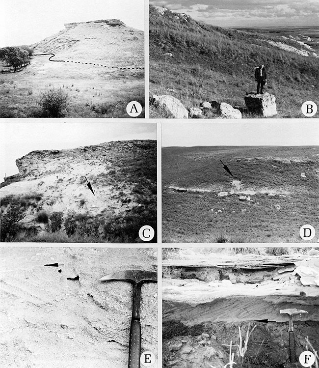
Figure 4--Characteristic exposures of Late Tertiary strata in Ellis County, Kansas, showing stratigraphic and topographic features. A. View east towards exposure of Tertiary strata along small creek. Sediments exposed as the bluff and upper slope represent consolidated deposits characteristically assigned to the Ogallala Formation. Lower half of slope is composed predominantly of well-sorted clays unlike sediments of the Ogallala Formation. Contact between Tertiary and Cretaceous strata is marked by the black line (Site 6). B. Typical weathering of consolidated sediments into large blocks (Site 47). C. View south towards characteristic bluff. Area by screens (arrow) is a quarry from which the vertebrates in Table 4 were recovered. This is also the type locality of Nassella pohlii sp. nov. (Site 39). D. View south towards Bemis Local Fauna locality (arrow) showing rolling topography and typical "mortar" beds. E. High-angle cross beds and clay drape (arrow) in conglomeratic sands bed (bed 1 at site 9a). F. Sand lens illustrating high-angle cross beds resting on well-sorted clays at a distinct erosional surface (arrow). Such sand lens are found in the lower, predominantly clay, Tertiary strata in western Ellis County (bed 3 at site 42).
Description of Sediments
"Algal" (psiolitic) limestone was noted at seventeen localities in Ellis County. At some localities the characteristic pink concentric structural nature (see Swineford, Leonard, and Frye, 1958) of the limestone was brilliantly developed while at other sites it was only faintly noticeable. This unit is now considered by most workers to be an edaphic structure formed as a result of climatic events of the Quaternary (Frye et al., 1974; Boellstorff, personal communication, 1975). For a review of the various early hypotheses regarding its origin, consult Bretz and Horberg (1949) or Swineford, Leonard, and Frye (1958).
A very distinctive horizon of opal with black dendrites, "moss agate," caps the sequence of Tertiary sediments at a number of sites in Ellis County. Similar rocks were noted by Elias (1931) in Wallace County. "Moss agate" appears to be of no stratigraphic significance and it apparently is a product of weathering.
The bulk of the deposits in the upper half of sequences in Ellis County consists of silts, sands, and conglomerates. They may variously be poorly to well sorted. The sediments consist predominantly of quartz grains, which contrasts somewhat with findings of other workers (Frye, Leonard, and Swineford, 1956). Primary structures such as imbrication and low and high angle cross beds were observed (Fig. 4E). The volcanic ash beds and marls noted in Ellis County occur in these upper, coarser sediments. Most fossils were recovered from the upper sequence of deposits (Fig. 5A-D). Fossils were found predominantly in the sands and silts, although they were found in the conglomerates as well. These beds are often densely cemented and form prominent outcrops which have been referred to in the literature as "mortar" beds (Fig. 4A-D).
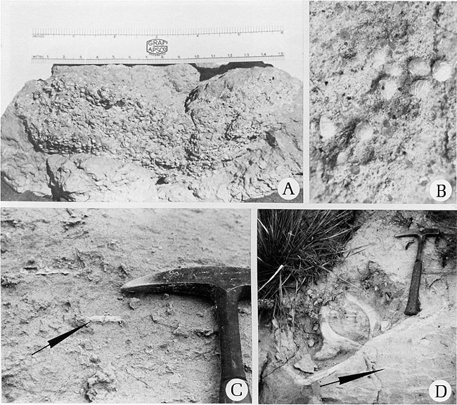
Figure 5--Typical occurrences of fossils. A. Mass accumulation of Berriochloa tuberculata Elias, probably a coprolite. Graminophyllum kansasensis sp. nov. was isolated from this mass (bed 2 at site 2). B. Small cluster of Biorbia fossilia (Berry) Cockerell (bed 4 at site 9a). C. Lenticular aggregations of organic matter of unknown origin (arrow). These fossils have been referred to in the literature as "Daemonelix" (bed 4 at site 9a). D. Large, thin-shelled tortoise (? Geochelone) with portions of carapace and pelvic girdle exposed. Note lenticular organic matter below carapace (arrow) (bed 2 at site 41).
Volcanic ash beds have been widely reported in late Tertiary deposits in the High Plains (Swineford and Frye, 1946; Carey et al., 1952; Frye and Leonard, 1955) and have been used recently in interpreting the stratigraphic successions of deposits in the High Plains, utilizing data from fission-track dating of volcanic glass shards (Boellstorff, 1976). Although one ash bed has been reported in nearby Trego County (Wilson, 1969), no previous reports of volcanic ash beds have been made in Ellis County. Tuffs have been discovered at a number of sites. At sites 21 and 28 the lower levels of the ash beds are extremely pure. These beds were apparently deposited very quickly with no subsequent reworking. At sites 9, 13, and 29 among others, this was not the case, as considerable contaminating sand is present. One pure sample was submitted for K/Ar age determination by Teledyne Isotopes. The results are presented in Table 2. All samples were done in duplicate. As the volume of radiogenic argon or the potassium content decreases, the size of the analytical error naturally increases. Although the potassium content of the rocks analyzed turned out to be favorable, the fine grain size resulted in a rather high atmospheric argon correction relative to the radiogenic argon. For this reason no less than the 20% error was reported. If material with well-defined crystals, especially with biotite or sanadine could be found, more reliable dates could be realized.
Table 2--Age determination of volcanic ash from site 21.
| Isotopes sample No. |
Isotopic age (m.y.) |
40 Rad scc Ar/gm x 10-5 |
40 % Ar Rad |
% K |
|---|---|---|---|---|
| KA 74-155 | 18±3.6 | .38 | 19.6 | 4.54 |
| .28 | 4.1 | 4.56 | ||
| The constants used for the age calculations are: λβ = 4.72 X 10⁻¹⁰ yr-1; λe = 0.585 x 10⁻¹⁰ hr-1 and K40 = 1.19 X 10⁻⁴ atom percent of natural potassium. | ||||
Extremely well-sorted clays were noted at a number of sites in Ellis County. These were generally restricted to the lower half of the sequence of sediments in Ellis County sections and represent depositional environments contrasting strongly with those represented by the sands and conglomerates higher in the sections. Erosional contacts between the clays and other sediments present were distinct (Fig. 4F). Elias (1931) noted similar clay beds in the lower portions of sequences of Tertiary deposits in Wallace County, and Russell (1929) noticed similar strata in Trego County. Elias called the beds in Wallace County "Woodhouse Clays," considering them a lateral lithofacies of deposits there. This does not seem likely in Ellis County deposits because of their consistent lower position. They more likely represent a different depositional period than the coarser sediments above. Possibly these clays might be sufficiently distinct and mappable to assume a formational status. I have seen no deposits in sediments considered "Ogallala" in Nebraska which approach these clay strata in size and extent. Breyer (1975) reported no clay beds in his studies of the Ogallala sediments in western Nebraska. Future detailed studies of this problem are needed.
Correlations and Age of Deposits
Definitions and utilization for correlation purposes of subdivisions within the Ogallala have been in the past and continue to be a problem. Some workers (Moore et al., 1951; Merriam, 1963; Zeller, 1968) consider the subdivisions of the Ogallala, i.e., Valentine, Ash Hollow, and Kimball (from oldest to youngest) to be members whereas others consider them to be formations (Lugn, 1939; Elias, 1942; Schultz and Stout, 1961; Voorhies, 1971). Where the type localities for subdivisions were designated in Nebraska they are lithologically distinct and can be used for local correlations (Elias, 1942). However, as one leaves these areas the distinctive lithologies disappear (Gregory, 1942; Zehr, 1974) and the subdivisions are either redefined on the basis of floral zones (Frye and Leonard, 1959) or they are considered to be probably inapplicable outside of the type localities or areas (Zehr, 1974).
The most intensively studied localities during the course of this investigation were those in Ellis and one (site 4) in adjoining Rooks counties, Kansas. Additional sites were studied in other parts of Kansas, Nebraska, and Colorado. As a result of these studies, it is now possible, at least in Ellis and Rooks counties, Kansas, to propose correlations of the deposits there (Pl. I). Comments on the relationships of more widely distributed deposits at sites in Nebraska and Colorado will be briefly summarized and possible correlations will be noted.
A general coarsening upward sequence of sediments was noticed in Ellis County deposits (Pl. I, graphic sections 6, 42, 9a-c). In the basal portions were brown and green clays which were often extremely well sorted. Within the clay beds, lenses of densely cemented sands were often present (Fig. 4F) These clays were best exposed at sites 6, 9, and 42. The medial portions of deposits were composed of silts and sands. Characteristically, these were reddish brown to grayish or cream in color and were less well sorted than the lower clays. It is these deposits that comprise the bulk of the Prolithospermum johnstonii-Nassella pohlii Zone. Finally, in the uppermost beds at a number of sites were coarse sands and conglomerates. These were poorly sorted with gravel to 15 cm in diameter noted at site 10. These beds are particularly well exposed at sites 7, 8, 9a, 9b, and 42.
A sequence similar to those noted in Ellis County was reported by Elias (1931) in Wallace County and by Russell (1929) in Trego County. I have also measured an exposure at Castle Rock in Gove County that displays the same coarsening upward sequence. Whether the deposits in Wallace, Trego, and Gove counties are genetically related to those in Ellis County is not known at this time.
Correlations in Ellis County were made on the basis of both lithology and floras wherever possible. The deposits represented at sites 42, 9a-c, 7, 8, and 33 are the most securely correlated. Especially valuable lithologically at these sites was the presence of a massive fine-medium sandy to silty bed (bed 4 at site 9a) characterized by being well to extremely well sorted. Often, but especially at site 8, well-sorted medium to coarse sand lentils a few cm long and perhaps 1 to 2 cm thick were also observed. Not infrequently the anthoecia, nutlets, achenes, and endocarps occurred in this bed as distinct lentils, clusters, or ? coprolites (Fig. 5A, B). Dense aggregations of root material were common in the upper half of this bed (Fig. 5C). Basically, the taxa of plant fossils in this bed included Berriochloa minuta, Prolithospermum johnstonii, and Nassella pohlii. Quite diagnostic but less frequent in occurrence was N. reynoldsii. Remains of thin-shelled tortoises were also characteristically found in this bed (Fig. 5D).
Another group of sites almost equally well correlated is 28, 29, and 21. The principal basis of this correlation lithologically is the tuff bed at each site. At 28 and 21, this tuff grades downward into pure volcanic ash and rests directly on fine sandy-silts.
Outside of the two previously mentioned groups, other sites in Ellis County are less securely correlated. Possible correlations, however, are indicated on Plate I.
At least a probable correlation can be drawn between groups of securely correlated sites (42, 7, 8, 9a, 9b) in northwestern Ellis County and those sites (28, 29, 21) in west central Ellis County. This correlation is based primarily on fossil plant evidences. Characteristic species of Nassella, either N. pohlii or N. reynoldsii, occur at the sites. Both species have been collected together at site 9, and I interpret their absence in collections where one occurs and the other is absent as a collecting artifact. Additionally, sequences of deposits in both areas are quite similar lithologically although absolute correlations on this basis are not yet possible.
One site in Nebraska is possibly correlated with deposits in Kansas. At UNSM collection site Ft-40 (site 35), an excellently preserved flora of anthoecia, endocarps, and nutlets was collected by Harry D. Gross, Russell Thomasson, and me from mortar beds to the east and stratigraphically above the main quarry (Thomasson, 1977a). The flora includes Prolithospermum johnstonii, Panicum elegans, Biorbia fossilia, and Celtis willistonii. Based strictly on this collection, and fully realizing the possibility for error, it would appear that the deposits at UNSM-FT40 are perhaps contemporaneous with those in the Prolithospermum johnstonii-Nassella pohlii zone in Ellis County, Kansas.
Near Wray, Colorado (site 45) a flora was collected by Mark Mathisen and me which included Berriochloa minuta, B. cf. intermedia, Biorbia fossilia, Cryptantha coroniformis, and Celtis willistonii. Sediments there are also somewhat similar to those in Ellis County. Possibly this site might be remotely correlated with deposits in Ellis County but further studies are necessary before this can be considered as affirmed.
Finally, some time was spent at the type locality (designated as sites 43, 44) of the Ash Hollow Member (Formation, Nebraska sense). Both the floras and sediments appear distinct from those in Ellis County and it may eventually be proven that deposits of the two regions cannot be correlated. Studies of anthoecia from the Ash Hollow type locality are presently the subject of a separate study by me.
At my suggestion, Steven B. Selva, Iowa State University, has conducted a biostratigraphic study of the diatoms from several freshwater limestones in the study area (Selva, 1976). He has indicated (personal communications, 1976) that the results of his studies with respect to the correlation of involved sediments are inconclusive at this time.
An important new vertebrate fauna was discovered at site 29 in Ellis County. This site is stratigraphically at about the middle of P. johnstonii-N. pohlii Zone. Vertebrate forms represented (Table 3) have been provisionally assigned a Hemphillian land mammal age (Tallan, 1978), which geochronologically would be considered late Miocene (Berggren and Van Couvering, 1974). This vertebrate fauna is well above the Hamburg local fauna described by Zehr (1974), which was assigned a Clarendonian land mammal age (middle to late Miocene). Turtle and snake remains from site 39 (Table 4) appear to indicate a late Miocene-early Pliocene age (J. A. Holman, Michigan State University, personal communication, June, 1976).
Table 3--Fossil vertebrates from the Bemis local fauna (JRT site 29) (from Tallan, 1978).
| Sternberg Memorial Museum (FHSM) |
JRT No. | Specimens |
|---|---|---|
| 14193-1 | 29-1 | Teleoceros |
| 14193-40 | 29-40 | Teleoceros |
| 14193-48 | 29-48 | Aphelops |
| 14193-51 | 29-51 | Teleoceros |
| 14193-38 | 29-38 | Prostennhops |
| 14193-2 | 29-2 | Megatylopus |
| 14193-6 | 29-6 | Megatylopus |
| 14193-20 | 29-20 | Dinohippus |
| 14193-41 | 29-41 | Leptarctus |
| 14193-9 | 29-9 | Ambystoma |
Table 4--Identified fossil vertebrates recovered at site 39.
| JRT Specimen No. |
Specimen | Remarks |
|---|---|---|
| 39-4, 39-5, 39-8, 39-10, 39-11, 39-12 | Snake elements (Elaphe aff. nebraskensis and vulpina); trunk vertebrae | All snake elements are probably from a single individual (personal communication, J. Alan Holman, 15 June 1976) |
| 39-6, 39-7, 39-9, 39-24, 39-25 | Same as above but cervical vertebrae | |
| 39-20, 39-30, 39-43, 39-50 | Same as above but caudal vertebrae | |
| 39-26, 39-28, 39-32, 39-33, 39-25, 39-39, 39-41, 39-42, 39-44, 39-45, 39-46 | Same as above but ribs | |
| 39-2 | Mole (? Hesperoscalops) humerus | |
| 39-1 | Ground squirrel (Spermophilus); lower jaw with teeth | |
| 39-no number | Large tortoise (? Geochelone) carapacial fragments |
In recent years absolute age determination of Tertiary deposits has been undertaken utilizing the fission-track analysis on various mineral crystals of volcanic ash beds. No age determinations using this method are yet available on volcanic ash from deposits in Ellis County. But, a significant number of dates have been made of many ashes of the late Tertiary deposits in the High Plains that contain vertebrate remains contemporaneous with those from Ellis County deposits. Ashes bracketing sediments considered as Ash Hollow have been dated at 6.8 ± 0.3 and 10.6 ±m.y. (Boellstorff, 1976) which would be late Miocene. A fission-track age determination of zircons from an ash in the Kimball member of the Ogallala Formation gave an age of 4.6 ± 1.0 m.y. (Izett, 1975) which would be late Miocene-early Pliocene.
In summary, sediments that are present in Ellis County appear to be of late Miocene-early Pliocene age.
Prev Page--Introduction || Next Page--Biostratigraphy
Kansas Geological Survey, Geology
Placed on web May 1, 2009; originally published September 1979.
Comments to webadmin@kgs.ku.edu
The URL for this page is http://www.kgs.ku.edu/Publications/Bulletins/218/03_geol.html