Kansas Geological Survey, Bulletin 212, originally published in 1976
Originally published in 1976 as Kansas Geological Survey Bulletin 212. This is, in general, the original text as published. The information has not been updated.
Soil profile descriptions often need to be interpreted and used by people with no extensive experience in working with the soil survey. Thus, public health officials investigating septic tank seepage fields, planners of developing urban areas, extension service workers, highway and construction engineers, students beginning training in soils, and many others need to be able to understand the different soils they encounter in their work (Olson, 1974). This publication provides these people with a single reference for the mechanics of making and interpreting a soil profile description.
This work was compiled from sources describing official procedures of the Soil Conservation Service (SCS) of the U.S. Department of Agriculture (USDA), including the Seventh Approximation and Soil Taxonomy (Soil Survey Staff, 1960, 1970, 1973), the Soil Survey Manual (Soil Survey Staff, 1951) and Supplement (Soil Survey Staff, 1962), from notes and outlines of Dr. M. G. Cline (Cline, 1964), and from many other sources. In most cases parts of this text were taken directly from the cited references. In some cases minor changes in organization and grammar were made, with no change in content of the subject matter.
Soils vary. The differences may range from very striking texture variations to more subtle minor variations of color. Soil differences dictate that the soils must be managed differently and will behave differently when used for agriculture, forestry, sewage disposal, foundations, pavements, and other things.
The basis for classification and understanding soils is the soil profile description made in the field, where soils occur. A soil profile is a vertical cut exposing the various parts of the soil. Laboratory investigations only supplement understanding of soil profile descriptions made in the field. As soil mapping is based on landscape occurrence of the same or similar soil profiles, it is important to realize that a soil profile description represents an actual area of soil (pedon or segment of the landscape), although a soil profile description is normally made in a single vertical cut, pit, or trench.
Many different methods are used for describing and studying soils (Clarke, 1957; Smyth, 1965; Nikol'skii, 1959; Low, 1954; Taylor and Pohlen, 1962; Brewer and Sleeman, 1963). The method most widely used and accepted is that developed during the mapping of soils since 1899 by the U.S. Department of Agriculture (Soil Survey Staff, 1951, 1960, 1962). This is the method presented in this publication. This standard method allows comparison and classification of different soils, even though the descriptions might have been made by different people at different times in different geographic areas.
The procedure for making and interpreting a soil profile description consists simply of comparing various properties of parts of an individual soil profile with descriptive standards that have been established for these various properties for all soil profiles. Obviously some people will have greater skill in making and interpreting descriptions than others, particularly due to the amount of experience in working with a wide range of different soils. Careful selection of standards for description, however, enables anyone with a willingness to learn to compare properties of soils with the clearly defined standards, and thus make and interpret a soil profile description.
A soil profile description can conveniently be made by following the official SCS form (Soil Survey Staff, 1951) for that purpose. This form consists of two parts:
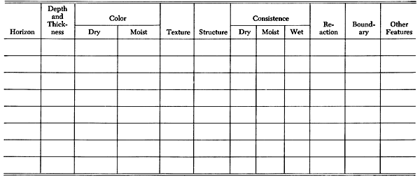
Table 1 illustrates the form for description of the environment. Table 2 gives the form for description of the various horizons into which the soil profile is subdivided. It is readily apparent that conscientious description of all the items in Tables 1 and 2 depicts the landscape and the soil quite comprehensively, in adequate detail for all interpretations except those involving special research projects. From this basic record of soil and environment data much information can be derived. The soil profile description indicates drainage and other characteristics that help show how the soils can best be used (Olson, 1964). The described soil factors include:
Table 1--Form for describing environment around the site (cut, pit, or trench) for a soil profile description (adapted from Soil Survey Staff, 1951).
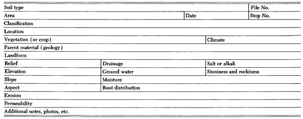
Table 2--Form for describing horizons of a soil profile (adapted from Soil Survey Staff, 1951).
The assembly of data recorded for a soil profile in Tables 1 and 2 and their statistical or computer analyses (Swanson, 1973) may take many forms. Table 3 illustrates the typical style of organization of the information. This is close to the style in which the soil profile description appears in the technical description of a published soil survey report (Tomasu and Roth, 1968). Table 4 illustrates a very detailed soil profile description made as part of a special research project studying a Williamson soil. The description in Table 4 is in greater detail than generally necessary for most soil studies. When considered with the other soils of New York State, it could be abstracted into simplest terms (Cline, 1963) by describing the Williamson soils under the headings:
| Soils on fine sorted material, mainly lacustrine but including loess and older alluvium | ||
| Alfisols, with fragipans in moderately well and imperfectly drained members; silt loam or very fine sandy loam, low in clay | ||
| Deep deposits--Moderately well-drained member of drainage sequence | ||
Table 3--Official soil profile description (revised 20 July 1967) of Richfield silt loam in northeast corner of section 12, township 28 south, range 36 west in Grant County, similar to that described in southwest corner of section 13, township 28 south, range 30 west, Gray County, Kansas (Tomasu and Roth, 1968).
| Horizon | Depth (in.) | Description |
|---|---|---|
| Ap | 0-6 | Grayish-brown (10YR 5/2) silt loam, very dark grayish-brown (10YR 3/2) moist; weak fine granular structure; slightly hard, friable; neutral; clear smooth boundary; horizon 4 to 8 inches thick. |
| B2t | 6-16 | Dark grayish-brown (10YR 4/2) heavy silty clay loam, very dark grayish-brown (10YR 3/2) moist; moderate medium subangular blocky structure; hard, firm; mildly alkaline; gradual smooth boundary; horizon 8 to 14 inches thick. |
| B3ca | 16-20 | Grayish-brown (10YR 5/2) silty clay loam, dark grayish-brown (10YR 4/2) moist; weak medium subangular blocky structure; hard, firm; contains few soft bodies of CaCO3; moderately alkaline, calcareous; clear smooth boundary; horizon 4 to 12 inches thick. |
| C1ca | 20-30 | Light gray (10YR 7/2) light silty clay loam, grayish-brown (10YR 5/2) moist; weak granular structure; slightly hard, friable; contains soft bodies of CaCO3; moderately alkaline, calcareous; gradual smooth boundary; horizon 8 to 20 inches thick. |
| C2 | 30-60 | Very pale brown (10YR 7/3) silt loam, brown (10YR 5//3) moist; structureless, massive; slightly hard, friable; porous; strongly alkaline, calcareous. |
Table 4--Soil profile description of Williamson silt loam from a pit dug in an apple orchard one mile east of the village of Alton in Wayne County, New York (Jha and Cline, 1963).
The Williamson silt loam soil profile consists of four principal horizons from the surface downward:
The profile description follows:
| Horizon | Depth (in.) | Description |
|---|---|---|
| An | 0-12 | Dark grayish-browb (10YR 4/2) silt loam; weak fine granular; friable; many fine roots; pH 5.0; abrupt wavy boundary; 8 inches thick at the edge to 14 inches thick in the middle of the apple-tree row. |
| B2 | 12-15 | Brown (7.5YR 5/4) silt loam; very weak very fine granular within very weak medium plates; very friable; many fine roots; pH 5.2; clear wavy boundary; 2 to 7 inches thick. |
| A'2 | 15-20 | Light brown (7.5YR 6/3) silt loam enclosing irregular-shaped bodies of pinkish-gray (7.5YR 6/2) very fine sandy loam (A'2e) 2 to 10 inches across that connect with parting planes between prisms of fragipan below; strong thin platy; firm; common vertical round holes 1 to 3 mm in diameter without smooth linings and surrounded by 2 to 3 mm of dark brown (7.5YR 4/4) to yellowish-brown (10YR 5/6) silt loam; common slightly firm to firm dark brown nodules in the pinkish-gray bodies; common fine roots; pH 5.2; abrupt wavy boundary; 2 to 8 inches thick. |
| B'21x | 20-32 | Dark brown (7.5YR 4/4) silt loam prisms separated by wedge-shaped extensions of pinkish-gray (7.5YR 6/2) very fine sandy loam bodies of A'2e. Prisms bounded by 1/4-inch rim of strong brown (7.5YR 5/6) silt loam; includes thin discontinuous horizontal bands and crudely vertical sheets of pinkish-gray (7.5YR 6/2) very fine sandy loam comparable to B'21e; nearly massive; very firm; few discontinuous vertical cleavage faces coated with a thin black skin; many 2 to 4 mm vertical holes with smooth clay linings; many 1/2-mm spherical voids with smooth clay linings; few roots; these penetrate less than 3 inches. Pinkish- gray material between prisms (B'21e) 2 inches wide at top; 1/2-inch wide at 32 inches; common slightly firm to firm 1 to 2 mm nearly black nodules; common vertical 2 mm holes with dark brown rims; locally nearly black coats on discontinuous cleavage faces at contact with the prism. Roots follow prism faces; pH 5.3; gradual wavy boundary; 10 to 15 inches thick. |
| B'22x | 32-44 | This is comparable to B'21x above, differing in having coarser prisms (12 to 24 inches across), thinner and fewer pinkish- gray sandy interprism zones, and fewer and less conspicuous dark coats on parting planes; pH 5.3; diffuse boundary; 10 to 13 inches thick. |
| B'3x | 44-56 | Dark brown (7.5YR 4/4) silt loam with few pinkish-gray (7.5YR 6/2) 1/4-inch horizontal bands of very fine sandy loam with many coarse 7.5YR 5/6 mottles; extensions of a few cleavage planes from prisms above divide the horizon into prisms 30 to 50 inches across; common 2 to 4 mm vertical holes lined with wax-like clayey material are bounded by 1/8-inch of 7.5YR 6/2 very fine sandy loam with a 1/4-inch band of 7.5YR 5/6 silt loam and extend through both sandy and silty layers; firm; pH 5.2; few roots in cleavage planes; abrupt smooth boundary; 11 to 12 inches thick. |
| C1 | 56-72 | Layers of brown (7.5YR 4/3) silt loam 2 to 6 inches thick separated by 1/8- to 1/4-inch layers of pinkish-gray (7.5YR 6/2) loamy very fine sand; common vertical 2 to 4 mm cylinders of 10YR 6/2 very fine sand bounded by 1/4-inch of 7.5YR 5/8 silt loam extend through all layers; common coarse 7.5YR 5/4 mottles; layers are massive; slightly firm; no roots; pH 5.2; arbitrarily divided from layer below. |
| C2 | 72-84 | Similar to C1. Arbitrarily divided for sampling. |
A soil profile description-properly made, understood, and interpreted-supplies a wealth of information about internal and external characteristics of the segment of the landscape with which it deals. By studying the soil profile description and accompanyiing data, one can tell what the landscape looks like and what its subsurface composition is. Interpretations can be made for all uses to which the soils must be put. Maps made by classifying similar soil profiles of a landscape show exactly which soils are located in each area. Profile descriptions representing soils from different places can be compared and classified--enabling each soil to be better understood in the natural order of things. The soil profile description in Table 5 illustrates how the descriptive methods can be applied to soils of far-away places in order to better understand them and compare them with soils with which we are more familiar.
Table 5--Soil profile description of Regur soil from pit near buildings on the State Experimental Farm at Achalpur, Madhya Pradesh, India (Simonson, 1954).
1. Typical Regur soil profile from traprock--near buildings on the State Experimental Farm at Achalpur, Madhya Pradesh, India.
| Horizon | Depth (in.) | Description |
|---|---|---|
| A11 | 0-8 in. | Very dark grayish-brown (10YR 3/2) clay; slightly hard, friable, plastic, sticky; moderate medium granular structure; few fine roots; medium and coarse lime concretions common to few; few fine traprock pebbles. |
| A12 | 8-30 in. | Very dark grayish-brown (10YR 3/2 to 3/4) clay; hard, friable, plastic, sticky; compound structure of moderate fine blocky peds crushing under some pressure to moderate medium granular peds; few fine roots; few medium lime concretions and fine traprock pebbles. |
| A3 | 30-38 in. | Dark grayish-brown (10YR 4/2) to brown (10YR 4/3) clay; slightly hard, friable, plastic, sticky; weak fine to medium blocky structure; few fine roots, few medium line concretions and fine traprock pebbles; this is a gradual horizon from the solum to the weatliered rock. |
| Cca | 38-52 in. | Mottled light yellowish-brown (10YR 6/4), light brownish gray (10YR 6/2), and pale brown (10YR 7/2) loam; mottles are fine to medium, distinct, and numerous; soft, friable, slightly plastic; the light colored patches seem to be mainly lime accretions; a few roots and a few traprock pebbles. This layer appears to be well weathered rock with a lime accumulation. |
| C | 52-80 in. | Dark yellowish-brown (10YR 4/4) loam flecked and mottled with light brownish-gray (10YR 6/2); mottles are distinct, fine to medium, and common; soft, friable, slightly plastic; essentially structureless in place but with weak fine granular peds when removed, few traprock pebbles. This seems to be well-weathered rock. |
This publication is intended to be a comprehensive guide for making and interpreting a soil profile description. Tables 6 and 7 and Appendix Table 1 list abbreviations and notations suggested for use with the forms in Tables 1 and 2. The forms have proved extremely useful as a guide for describing soils. The procedures will probably be modified, however, as our knowledge of soils increases. People describing and using soils should not be bound by convention, but should use their initiative freely to describe special and significant soil features in terms communicable to other scientists. The use of special tools (such as photography) must be fully employed for description and study of soils, and for communication of soils information to other scientists and laymen.
Table 6--Abbreviations and notations for making a soil profile description, suggested for use with the form in Table 1 (adapted from Soil Survey Staff, 1951, p. 140 and 141).
Table 7--Abbreviations and notations for making a soil profile description, suggested for use with the form in Table 2 (adapted from Soil Survey Staff, 1951, p. 139 and 140).
|
Horizon--Use standard horizon nomenclature (Soil Survey Staff, 1962). Depth--In inches or centimeters from the top of the A1, or surface mineral horizon, except for the surface of peat or muck soils (Soil Survey Staff, 1951, p. 185). Thickness--Average thickness and range, as 6 (4-8) inches. The range should be observed for each cut, pit, or trench described and as published gives thickness range for the survey area. Color--Soil colors are indicated by using the appropriate Munsell notation such as 5YR 5/3. If the soil mass is one solid color, only one notation is required. If the outsides of aggregates differ significantly from their interiors, both colors are needed. The description of mottled soil horizons needs to include the color of the matrix and the color, or colors, of the principal mottles plus a description of the pattern of mottling. Colors can be given in terms of the Munsell notation or linguistic equivalents, if exact measurement is not possible or necessary. The pattern may be noted as follows:
Thus a medium gray soil horizon mottled with yellow and reddish brown could be noted as 10YR 5/1, c3d, 10YR 7/6 and 5YR 4/4 or 10YR 5/1, c3d, yellow and reddish brown. Texture--The following notations are suggested:
Structure--Use standard terms (Soil Survey Staff, 1951, p. 228).
Consistence--The notation of consistence varies with moisture content (Soil Survey Staff, 1951, p. 231-234).
Reaction--Use pH figures. Indicate effervescence with HCI as:
Boundary--The lower boundary is described for each horizon according to:
Thus an abrupt irregular boundary could be described as ai. Special features
Other special features may be described as additional notes. |
The description of a soil profile consists mainly of individual examination of its separate horizons (Soil Survey Staff, 1962). Appendix Table 2 lists and briefly describes symbols used to designate soil horizons. A soil horizon is a layer of soil, approximately parallel to the soil surface, with characteristics produced by or influencing soil forming processes. One soil horizon is commonly differentiated from an adjacent one at least partly on the basis of characteristics that can be seen in the field. Laboratory data also are required sometimes for the identification and designation of horizons for their more detailed characterization. The soil profile, as exposed in a road cut or pit, includes the collection of all the genetic horizons, the natural organic layers on the surface, and the altered and geologic materials and other layers that influence the genesis and behavior of the soil. The profile representing soil map units must be characteristic of pedons representing large areas of the same kind of soil.
Many soils have horizons inherited from stratified geologic deposits, in addition to genetic soil horizons. In making soil examinations, all distinguishable horizons are separately described regardless of genesis. These descriptions must be completely objective. They are the basis of soil classification. Nothing can substitute for them. Laboratory data on collected samples make soil descriptions more valuable. Without the soil descriptions the laboratory data cannot be safely interpreted.
Profiles of soils have properties different from those of the original geologic material. Thus a soil profile in an alluvial terrace has characteristics partly due to alluvial stratification and partly due to soil forming processes, acting concurrently or at different times. A soil with a well-developed profile may be gradually covered with volcanic ash, loess, windblown sand, or alluvium without seriously injuring the vegetation. The surface horizon may become thickened in these cases as the lower part of the soil profile gradually passes beyond reach of active soil forming processes.
Soil profiles vary widely in thickness, from mere films to profiles many feet thick. Thickness differences are due to degree of weathering of the original geologic material. Generally, in temperate regions, soil profiles need to be examined to depths of three to five feet. Soils are generally thinner toward the poles and thicker toward the equator. Even in temperate regions, however, deeper horizons and geologic deposits to six feet or more may be very important for many different kinds of soil uses.
Soil profiles also vary widely in the degree to which genetic horizons are expressed. On nearly fresh geologic deposits (new alluvial fans, sand drifts, blankets of volcanic ash) no genetic horizons may be distinguished at all. As soil formation proceeds, changes in the geologic deposits may be detected in their early stages only by laboratory study of the samples, and then later with gradually increasing clarity in the field. In describing a soil profile, one usually locates the boundaries between horizons, measures their depth, and studies the profile as a whole before describing and naming individual horizons. The blanks in the form in Table 1 are filled out at this time.
It is not absolutely necessary to name the various soil horizons in order to make a good description of a soil profile (Soil Survey Staff, 1962). Yet the usefulness of profile descriptions is greatly increased by the proper use of genetic designations (like A, B, C). Such interpretations show the genetic relationships among the horizons within a profile, whereas simple numbers or undefined letters tell nothing but depth sequence. The genetic designations make possible useful comparisons among soils. For example, it is not possible to usefully compare arbitrarily defined 12-24 inch layers of different soils, but B horizons can be usefully compared.
Horizon designations are symbols indicating the judgment of the person describing the soil relative to kind of departure from the original geologic material from which the soil formed. Each symbol indicates an estimate, not a proven fact. The symbol implies that one must reconstruct mentally the character of the original geologic material.
Master horizons are designated as O, A, B, C, and R. Criteria for naming the master horizons are (Soil Survey Staff, 1962):
O--Organic horizons of mineral soils that are:
The O horizons may be present at the surface horizon of mineral soils, or at any depth beneath the surface in buried soils, but they have been formed from organic litter derived from plants and animals and deposited on the surface. The O horizons do not include soil horizons formed by illuviation of organic material into mineral material, nor do they include horizons high in organic matter formed by a decomposing root mat below the surface of mineral material. Organic horizons at the surface may be rapidly altered in thickness. Thus thickness of organic horizons that are at the surface are always measured upward from the top of the underlying mineral material.
Two subdivisions of 0 horizons are recognized:
A--Mineral horizons consisting of:
Mineral horizons contain less than 30 percent organic matter if the mineral fraction contains more than 50 percent clay or less than 20 percent organic matter if the mineral fraction has no clay. Intermediate clay content requires proportional content of organic matter.
A1--Mineral horizons, formed or forming at or adjacent to the surface, in which the feature emphasized is an accumulation of humified organic matter intimately associated with the mineral fraction.
The mineral particles of A1 horizons have coatings of organic material, or the soil mass is darkened by organic particles; the horizon is as dark as, or darker than, adjacent underlying horizons. The mineral fraction may be unaltered or may have been altered in a manner comparable to that of A2 or B horizons. The organic fraction of A1 horizons is assumed to have been derived from plant and animal remains deposited mechanically on the surface of the soil, or deposited within the horizon without translocation of humified material through an intervening horizon that qualifies for a horizon designation other than A1.
A2--Mineral horizons in which the feature emphasized is loss of clay, iron, or aluminum, with resultant concentration of quartz or other resistant minerals in sand and silt sizes.
Such A2 horizons are commonly but not necessarily lighter in color than an underlying B. In some soils the color of the A2 horizon is determined by that of the primary sand and silt particles, but in many soils, coats of iron or other compounds, apparently released in the horizon and not translocated, mask the color of the primary particles. An A2 horizon is most commonly differentiated from an overlying A1 by lighter color and is generally measurably lower in organic matter. An A2 horizon is most commonly differentiated from an underlying B in the same profile by lighter color, or coarser texture, or both. A2 horizons are commonly near the surface, below an O or A1 horizon and above a B, but the symbol A2 may be used either above or below subsurface horizons; position in the profile is not diagnostic. In bisequal soils a prime symbol designates a horizon of the lower sequence (A'2). For horizons at the surface that would qualify equally well as either A1 or A2, the designation A1 is given preference over A2.
A3--A transition horizon between A and B dominated by properties characteristic of an overlying A1 or A2 but having some subordinate properties of an underlying B.
No distinction is made between the different kinds of horizons that are transitional from A1 or A2 to different kinds of B. Obviously they may be quite unlike one another, but the burden of characterization rests on the description of the transitional horizon, plus inferences that can be made after noticing the symbols assigned to the overlying and underlying horizons. The symbol A3 is normally used only if the horizon is underlain by a B horizon. However, where the profile is truncated from below in small places by rock, so as to eliminate the horizon that would be designated B, the symbol A3 may be used for the horizon that is above the rock. For example, in one part of a pedon, a horizon may be transitional between A and B, and thus be appropriately designated A3. But, in another part of the same pedon, the same horizon rests on rock and may appropriately be called A3, even though there is no underlying B.
The symbol A3 is confined to those kinds of transitional zones in which some of the properties of the underlying B are superimposed on properties of A throughout the soil mass. Those kinds of transitional horizons in which parts that are characteristic of A enclose parts characteristic of B are classified as A and B.
AB--A horizon transitional between A and B, having an upper part dominated by properties of A and a lower part dominated by properties of B, but the two parts cannot conveniently be separated into A3 and B1.
Such combined horizons are normally too thin to separate.
A and B--Horizons that would qualify for A2 except for included parts constituting less than 50 percent of the volume that would qualify as B.
Commonly, A and B horizons are predominately A2 material partially surrounding thin, columnar upward extensions of the B or wholly surrounding small isolated spheres, ellipsoids, or other bodies that would qualify as B. In such horizons the A2 appears to be encroaching on an underlying B.
AC--A horizon transitional between A and C, having subordinate properties of both A and C, but not dominated by properties characteristic of either A or C.
B--Horizons in which the dominant feature is one or more of the following:
It is obviously necessary to be able to identify the kind of B before one can establish that a horizon qualifies as B. There is no common diagnostic property or location in the profile by means of which all kinds of B can be identified. Marginal cases exist in which a horizon might qualify as either of two kinds of B. In such cases, the horizon description should indicate the kind of B that characterizes the dominant condition, in the judgment of the person describing the soil. Laboratory work may be needed for identification of the kind of B, or even to determine that a given horizon is a B.
B1--A transitional horizon between B and A1 or between B and A2 in which the horizon is dominated by properties of an underlying B2 but has some subordinate properties of an overlying A1 or A2.
An adjacent overlying A1 or A2 and an adjacent underlying B2 are essential to characterization of a horizon as B1 in a virgin soil. In a few instances the horizon may still be recognized in a truncated soil by comparing the truncated profile with an undisturbed profile of the same soil. The symbol B1 is confined to those kinds of transitional horizons in which some properties of the overlying adjacent A1 or A2 are superimposed on properties of B throughout the mass of the transitional horizon. Those kinds of transitional horizons containing parts characteristic of B, separated by abrupt boundaries from parts characteristic of an overlying A2, are classified as B and A.
B and A--Any horizon qualifying as B in more than 50 percent of its volume including parts that qualify as A2.
These horizons commonly have many vertical tongues of A2 material that extend downward into the B from the A2 or they have thin horizontal bands of A2 material that lie between thicker bands of B and are connected with tongues extending from the A2. Tubes filled with A1 material, as in krotovinas or earthworm channels, in a B horizon should be described but should not be designated as B and A. Many B horizons have A2 material in widely spaced narrow cracks. Such features should be described, but the horizon should be designated as B and A only if the A2 material constitutes more than 10 percent of the volume of the horizon.
B2--The part of the B horizon where the properties on which the B is based are without clearly expressed subordinate characteristics indicating that the horizon is transitional to an adjacent overlying A or an adjacent underlying C or R.
This does not imply that the B2 horizon in a given profile must express to a uniform degree the properties diagnostic of B or that it must be confined to a zone of maximum expression in the absolute sense. The B3 horizon, which is transitional from B2 to C, commonly exhibits the subordinate properties of C by expressing in lower degree the properties of an adjacent B2. Before the designation B3 is justified, the degree of expression of B2 horizon characteristics must be low enough that the properties of C are clearly evident. The definition does not imply that a given kind of B2 has the same degree of expression in all profiles. In some profiles the most strongly expressed part of the B horizon, which would be designated B2, may be as weakly expressed as B3 in other profiles. The designation B2 is used strictly within the frame of reference of a single profile and not in an absolute sense of degree.
B3--A transitional horizon between B and C or R in which the properties diagnostic of an overlying B2 are clearly expressed but are associated with clearly expressed properties characteristic of C or R.
The designation B3 is used only if there is an overlying B2, even if the properties diagnostic of B are weakly expressed in the profile. Where an underlying material presumed to be like the parent material of the solum is absent (as in A-B-IIC profiles) B3 is used below B2 in the sense of a horizon transitional to an assumed original parent material. Use of the symbol IIC involves an estimate of at least the gross character of the parent material of the horizons above it. B3 in such cases is based on this estimate of the properties of the parent material of the B. B3 is not used as a horizon transitional from B2 to IIC or IIR.
C--A mineral horizon or layer, excluding bedrock, that is either like or unlike the material from which the solum is presumed to have formed, relatively little affected by pedogenic processes, and lacking properties diagnostic of A or B but including materials modified by:
This definition is intended to exclude horizons that meet the requirements of A or B but to include certain kinds of alteration that, historically, have been considered to be little influenced by the activity of organisms. These alterations include chemical weathering deep in the soil. Some soils are presumed to have developed in materials already highly weathered, and such weathered material that does not meet requirements for A or B is considered C. Development of the firmness, brittleness, and high density characteristic of fragipans is, by itself, not a criterion of A or B. Fragipans that have distinct silicate clay concentrations are to be indicated as Bx or simply as B. Fragipans lacking such clay concentration, however, are considered to be within the definition of C and are designated Cx. Accumulations of carbonates, gypsum, or more soluble salts are permitted in C horizons if the material is otherwise considered to be little affected by other processes that have contributed to genesis of associated horizons. Such horizons are designated Cca, Ccs, or Csa. Even induration by such materials is permitted and this can be indicated by the suffix m, as in Ccam. Induration by alkali-soluble siliceous material is also permitted and may be indicated by Csim. Induration by iron and silica does not exclude the horizon from C, and horizons or layers thus indurated would be designated Cm. Horizon C, as defined, is intended to include the diagnostic horizons indicated by ca, cs, and sa, and the alkali-soluble pans, the iron-silica pans, and the fragipans, provided these layers do not meet the requirements of B. C horizons may include contrasting strata of unconsolidated material, and gleyed horizons that cannot be designated as A or B. The C horizon has often been incorrectly called parent material, but it is really impossible to find the parent material from which the A and B horizons have developed since that material has been altered. Arabic numerals applied to C horizons indicate only vertical sequence within the C.
R--Underlying consolidated bedrock, such as granite, sandstone, or limestone. If presumed to be like the parent rock from which the adjacent overlying laver or horizon was formed, the symbol R is used alone. If presumed to be unlike the overlying material, the R is preceded by a Roman numeral denoting lithologic discontinuity. An R horizon is generally composed of hard rock (lithic contact with overlying soil) but may also be soft rock (paralithic contact with overlying soil) such as marl or soft shale.
Subordinate symbols are used as suffixes after master horizon designations to indicate dominate features of different kinds of master horizons.
b--Buried soil horizon.
The symbol b is added to the designation of a buried genetic horizon or horizons. Horizons of another solum may or may not have been formed in the overlying material, which may be similar to or different from the assumed parent material of the buried soil.
ca--An accumulation of carbonates of alkaline earths, commonly of calcium.
This symbol is applied to A, B, or C horizons. Possible combinations are A1ca, A3ca, B1ca, B2ca, and B3ca. An A2ca horizon is also possible where accumulation has occurred in an A2 formed under different conditions, but it is not common. The presence of secondary carbonates alone is not adequate to justify the use of the ca symbol. The horizon must have more carbonates than the parent material is presumed to have bad.
cs--An accumulation of calcium sulfate.
This symbol is used in a manner comparable to that of ca. Calcium sulfate accumulations commonly occur in the C below ca accumulations in cherozemic soils, but may occur in other horizons as well. If the symbol cs is used, the horizon must have more sulfates than the parent material is presumed to have had.
cn--Accumulations of concretions or hard nonconcretionary nodules enriched in sesquioxides with or without phosphorus.
The nodules indicated by the symbol cn must be hard when dry but need not be indurated. The horizon description should characterize the nodules. Nodules, concretions, or crystals do not qualify as cn if they are of dolomite or more soluble salts, but they do qualify if they are of iron, aluminum, manganese, or titanium.
f--Frozen soil.
The suffix f is used for soil that is thought to be permanently frozen.
g--Strong gleying.
The suffix g is used with a horizon designation to indicate intense reduction of iron during soil development, or reducing conditions due to stagnant water, as evidenced by base colors that approach neutral, with or without mottles. In aggregated material, ped faces in such horizons generally have chroma of two or less as a continuous phase, and commonly have few or faint mottles. Interiors of peds may have many prominent mottles but commonly have a network of threads or bands of low chroma surrounding the mottles. In soils that are not aggregated, a base chroma of 1.0 or less, with or without mottles, is indicative of strong gleying. Hues bluer than 10Y are also indicative of strong gleying in some soils. Horizons of low chroma in which the color is due to uncoated sand or silt particles are not considered to be strongly gleyed. Although gleying is commonly associated with wetness, especially in the presence of organic matter, wetness by itself is not a criterion of gleying. The symbol g may be applied to any of the major symbols for mineral horizons and should follow the horizon designations, as A2g, A21g, A3g, B1g, B2g, B3g, and Cg. Bg may be used if gleyed B horizons cannot be subdivided into B1, B2, and B3.
No lower case letter is used as a suffix with horizon designations to indicate reduction of iron less intense than that indicated by g. Conditions not given a special designation but described in detail are those associated with:
h--Illuvial humus.
Accumulations of decomposed illuvial organic matter, appearing as dark coatings on sand or silt particles, or as discrete dark pellets of silt size, are indicated by h. This suffix follows the letter B or a subdivision of B, as Bh or B2h.
ir--Illuvial iron.
Accumulations of illuvial iron as coatings on sand or silt particles or as pellets of silt size. In some horizons the coatings have coalesced, filled pores, and cemented the horizon.
m--Strong cementation, induration.
The symbol m is applied as a suffix to horizon designations to indicate irreversible cementation. The symbol is not applied to indurated bedrock. The symbol is confined to indurated horizons that are essentially (more than 90 percent) continuous, though they may be fractured.
p--Plowing or other disturbance.
The symbol p is used as a suffix with A to indicate disturbance by cultivation or pasturing. Even though a soil has been truncated and the plow layer is clearly in what was once B horizon, the designation Ap is used. When an Ap is subdivided, the arabic number suffixes follow, as Ap1 and Ap2, because the Ap is considered comparable to A1, A2, or B2.
sa--An accumulation of salts more soluble than calcium sulfate.
This symbol may be applied to the designation of any horizon and in its manner of use is comparable to that described for ca or cs. If the symbol is used, the horizon must have more salt than the parent material is presumed to have had.
si--Cementation by siliceous material, soluble in alkali. This symbol is applied only to C.
The cementation may be nodular or continuous. If the cementation is continuous the symbol sim is used.
t--Illuvial clay.
Accumulations of translocated silicate clay are indicated by the suffix t (German ton, clay). The suffix t is used only with B horizons (as B2t) to indicate their nature. The ratio of the clay content of the eluvial horizon to the illuvial horizon needs to be 1.2 or larger.
x--Fragipan character.
The symbol x is used as a suffix with horizon designations to indicate genetically developed properties of firmness, brittleness, high density, and characteristic distribution of clay that are diagnostic of fragipans. Fragipans, or parts of fragipans, may qualify as A2, B, or C. Such horizons are classified as A2, B, or C, and the symbol x is used as a suffix to indicate fragipan character. Unlike comparable use of supplementary symbols, the symbol x is applied to B without the connotative arabic numeral normally applied to B. Arabic numerals used with C to indicate only vertical subdivision of the horizon precede the x in the symbol, as C1x and C2x.
In a single profile it is often necessary to subdivide the horizons for which designations are provided (Soil Survey Staff, 1962). Horizons like Ap, A1, A2, A3, B1, B2, B3, or C can be subdivided so that detailed studies of morphology, sampling, and similar work can be correctly recorded. In some cases, such subdivision is arbitrary in relation to differences observable in the field. In other cases it may be necessary to differentiate within a horizon on bases not provided by unique horizon symbols. In all such cases, the subdivisions are numbered consecutively, with arabic numbers, from the top of the horizon downward, as B21, B22, and B23. If the suffixes consisting of lower case letters are being used, the arabic numbers precede all lower case suffixes except p as B21t, C1g, C2g, but Ap1 and Ap2.
Roman numerals are prefixed to the appropriate horizon designations when it is necessary to number a series of layers of contrasting material consecutively from the surface downward (Soil Survey Staff, 1962). A soil that is all in one kind of material is all in material designated by the numeral I. This numeral therefore can be omitted from the symbol, as it is understood that all the material is I. Similarly, the uppermost material in a profile having two or more contrasting materials is always designated I. Consequently, for the topmost material, the numeral I can be omitted from the symbol because it is always understood. Numbering starts with the second layer of contrasting material, which is designated II, and each contrasting material below this second layer is numbered consecutively, III, IV, and so on, downward as part of each horizon designation. Even though a layer below a horizon designated by II is similar to the topmost horizon it is given the appropriate consecutive number in the sequence. Where two or more horizons developed in one of the numbered layers, the Roman numeral is applied to all the horizon designations in that material.
Following are two examples of horizon sequences using this convention:
A1 - A2 - B1 - B21 - IIB22 - IIB3 - IIC1 - IIIC2
A1 - A2 - B1 - B2 - IIA'2 - IIB'X - IIC1x - IIIC2x - IIIC3 - IVR
In the first example, the first contrasting layer is unnumbered; the second layer, starting in the B2, is indicated by Roman numeral II, as IIB22; the third, within the C, by the symbol IIIC. In the second example, the first contrasting layer is unnumbered; the second, starting at the top of the A'2 horizon, is numbered II; the third, starting in the middle of the fragipan, is numbered III, even though the fragipan is partly in C material; and the fourth, starting below the C, is indicated by IVR. Arabic numerals are used independently of the Roman numerals, in the conventional manner, both as connotative symbols and for vertical subdivision.
A lithologic discontinuity is a significant change in particle size distribution or mineralogy that indicates a difference in the material from which the horizons have formed. A change in the clay content associated with an argillic horizon (textural B) does not indicate a difference in parent material. Appearance of gravel, or a change in the ratios between the various sand separates, will normally suggest a geologic difference in parent materials. One purpose in identifying lithologic discontinuities is to distinguish between those differences between horizons that are pedogenic and those that are geologic. Consequently, a designation with a different Roman numeral would not normally be used for a buried soil in a thick loess deposit. The difference between the properties of the buried soil and the overlying loess are presumably pedogenic. But a stone line usually indicates a need for another Roman numeral. The material above the stone line is presumed to be transported. If the transport was by wind or water, one must suspect that during the movement there was some sorting of the material according to size.
Profiles of soils having well-developed microrelief cannot be satisfactorily described from pits (Soil Survey Staff, 1962). To describe such soils, or to understand how one soil profile merges into another at the soil boundary, a long trench is dug so that horizons may be measured, described, sketched, and sampled at appropriate horizontal intervals. Small stakes may be set on the margin of the trench at 6 or 12 inch intervals as reference points. Using one stake as a zero point, the relative elevations of the others can be measured with an ordinary surveyor's level or Y-level.
In order to observe any horizontal cracking or patterns in the soil, it is often revealing to remove soil horizons, one by one from the top down, from an area of a square yard or more. One may, for example, discover gross hexagonal cracking of hardpans or claypans, unsuspected from the vertical cut alone, that suggests previous influence of freezing, moistening, or desiccation that have been interrupted by coverings now changed to a part of the soil profile.
Historical and logical usage determines the following six conventions (Soil Survey Staff, 1962) for use of symbols:
Depth and thickness of soil horizons must be carefully observed and recorded in making a soil profile description (Soil Survey Staff, 1962). The description of the profile as a whole can be aided greatly by a scaled diagram, sketch, or photograph on which the horizon boundaries are shown (Nikiforoff, 1936). Range in thickness is conventionally given for each horizon in each description, but when published in a soil survey report it covers the range in thickness of horizons for that soil for the entire survey area.
If the sets of figures for depth and thickness vary widely, it will be necessary to give the two sets separately to avoid confusion. The upper boundary of a B2 horizon, for example, may lie from 10 to 18 inches beneath the top of an A1 horizon, and the lower boundary may lie from 20 to 32 inches below the top of the A1; the thickness may vary from 8 to 16 inches, not 2 to 22 inches as might be interpreted from the figures for depth below the top of the A1 (Soil Survey Staff, 1962). Even the figures for thickness and for depth do not describe very irregrular horizons adequately. The main body of the A2 of a Podzol, for example, may be 5 to 8 inches thick, with an upper boundary 0 to 1/2-inch deep, and a lower boundary generally 5 to 8 inches deep but with irregular tongues extending down to 18 inches. The lower boundary of the underlying B2 may vary similarly from as little as 10 inches deep to as much as 24 inches, but with a thickness of only 4 inches to not more than 12 inches.
In sandy Spodosols with microrelief it is not unusual to find tongues of A2 actually bending under the B2 in such a way that a vertical cut into the soil will pass through A1, A2, B2, back into a bulging tongue of A2, then into B2 again, and finally through the B3 into the C. This example illustrates the need for a trench for examining soil profiles and especially for taking samples, to prevent serious errors in interpreting what one sees. Many soil horizons have similar tongues or other discontinuities.
Nearly every soil profile consists of several horizons differing in color. The complete color description must be presented for every soil horizon examined and described in the field (Soil Survey Staff, 1960, 1951).
Soil colors are most conveniently measured by comparison with a color chart (Soil Survey Staff, 1960). Appendix tables 3 and 4 and appendix figures 1-11 summarize methods of describing soil colors and soil color chart pages. The color chart generally used with soil is a modification of the Munsell color chart (Munsell Color Company, 1954, online at http://www.xrite.com/top_munsell.aspx) and includes only that portion needed for soil colors, about one-fifth of the entire range of color. It consists of some 175 different colored papers, or chips, systematically arranged, according to their Munsell notations, on cards carried in a loose-leaf notebook. The arrangement is by hue, value, and chroma--the three simple variables that combine to give all colors. Hue is the dominant spectral (rainbow) color; it is related to the dominant wavelength of the light. Value refers to the relative lightness of color and is a function (approximately the square root) of the total amount of light. Chroma (sometimes called saturation) is the relative purity or strength of the spectral color and increases with decreasing grayness.
In the soil color chart, all colors on a given card are of a constant hue, designated by the symbol in the upper right-band corner of the card. Vertically, the colors become successively lighter by visually equal steps as their value increases. Horizontally, they increase in chroma to the right and become grayer to the left. The value and chroma of each color in the chart is printed immediately beneath the color. The first number is the value, and the second is the chroma. As arranged in the chart the colors form three scales:
The nomenclature for soil color consists of two complementary systems:
Neither of these alone is adequate for all purposes. The color names are employed in all descriptions for publication and for general use. The Munsell notation is used to supplement the color names wherever greater precision is needed, as a convenient abbreviation in field descriptions, for expression of the specific relations between colors, and for statistical treatment of color data. The Munsell notation is especially useful for international correlation, since no translation of color names is needed. The names for soil colors are common terms now so defined as to obtain uniformity and yet accord, as nearly as possible, with past usage by soil scientists. Bizarre names like rusty brown, tan, mouse gray, lemon yellow, and chocolate brown should never be used.
The Munsell notation for color consists of separate notations for hue, value, and chroma, which are combined in that order to form the color designation. The symbol for hue is the letter abbreviation of the color of the rainbow (R for red; YR for yellow-red, or orange; Y for yellow) preceded by numbers from 0 to 10. Within each letter range, the hue becomes more yellow and less red as the numbers increase. The middle of the letter range is at 5; the zero point coincides with the 10 point of the next redder hue. Thus 5YR is in the middle of the yellow-red hue, which extends from 10R (zero YR) to 10YR (zero Y).
The notation for value consists of numbers from 0 (for absolute black) to 10 (for absolute white). Thus a color of value 5/ is visually midway between absolute white and absolute black. One of value 6/ is slightly less dark, 60 percent of the way from black to white, and midway between values of 5/ and 7/.
The notation for chroma consists of numbers beginning at 0 for neutral grays and increasing at equal intervals to a maximum of about 20, which is never really approached in soil. For absolute achromatic colors (pure grays, white, and black), which have zero chroma and no hue, the letter N (neutral) takes the place of a hue designation.
In writing the Munsell notation, the order is hue, value, chroma, with a space between the hue letter and the succeeding value number, and a virgule between the two numbers for value and chroma. If expression beyond the whole numbers is desired, decimals are always used, never fractions. Thus the notation for a color of hue 5YR, value 5, chroma 6, is 5YR 5/6, a yellowish red. The notation for a color midway between the 5YR 5/6 and 5YR 6/6 chips is 5YR 5.5/6; for one midway between 2.5YR 5/6 and 5YR 6/8, it is 3.75YR 5.5/7. The notation is decimal and capable of expressing any degree of refinement desired. Since color determinations cannot be made precisely in the field (generally no closer than half the interval between colors in the chart), expression of color should ordinarily be to the nearest color chip.
In using the color chart, accurate comparison is obtained by holding the soil sample above the color chips being compared. Rarely will the color of the sample be perfectly matched by any color in the chart. The probability of having a perfect matching of the sample color is less than one in one hundred. It should be evident, however, which colors the sample lies between and which is the closest match. The principal difficulties encountered in using the soil color chart are:
In addition, the chart does not include some extreme dark, strong (low value, high chroma) colors occasionally encountered in moist soils. With experience, these extreme colors lying outside the range of the chart can be estimated. Then, too, the ability to sense color differences varies among people, even among those not regarded as color blind.
While important details should be given, long involved designations of color should generally be avoided, especially with variegated or mottled colors. In these, only the extreme or dominant colors need be stated. Similarly, in giving the color names and Munsell notations for both the dry and moist colors, an abbreviated form, such as reddish brown (5YR 4/4; 3/4, moist), simplifies the statement.
By attempting detail beyond the allowable accuracy of field observations and sample selection, one may easily make poorer soil descriptions than by expressing the dominant color simply. In all descriptions, terms other than the ones given on these charts should be used only in rare instances, and then only as supplemental expressions in parenthesis where some different local usage is common.
A single horizon may be uniform in color or it may be streaked, spotted, variegated, or mottled in many ways (Soil Survey Staff, 1960). Local accumulations of lime or organic matter may produce a spotted appearance. Streaks or tongues of color may result from the seepage downward from overlying horizons of colloids, organic matter, or iron compounds. Certain combinations of mottled colors, mainly the grays and browns, indicate impeded drainage. The word mottled means marked with spots of color. Some mottled colors occur unassociated with poor drainage, either past or present. A mottled or variegated pattern of colors occurs in many soil horizons and especially in parent materials that are not completely weathered.
Mottling in soils is described by noting:
The color of the mottles may be defined by using the Munsell notation, as with other soil masses, but usually it is sufficient and even better to use the standard linguistic equivalents, because precise measurement of the color of the mottles is rarely significant. In fact, descriptions of soil horizons containing several Munsell notations are difficult to read rapidly. The pattern of mottles can be conveniently described (Simonson, 1951) by three sets of notations:
1. Contrast--Contrast may be described as faint, distinct, or prominent as follows:
2. Abundance--Abundance of mottles can be indicated in three general tentative classes as few, common, or many, based upon the relative amount of mottled surface in the unit area of the exposed soil horizon, as follows:
3. Size--Size refers to the approximate diameters of individual mottles. Three relative size classes can be used as follows:
In the detailed examination of some soil horizons, it may be necessary to add still further notes on the mottling to indicate whether or not the boundaries of the mottles are sharp (knife-edge), clear (less than 2 mm wide), or diffuse (more than 2 mm wide). Although many mottles are roughly circular in cross section, others are elongated and merge into streaks or tongues. Although, normally, mottling carries no inferences of differences in texture as compared to the matrix, many soils show mottling in a freshly exposed horizon because of the slicing of incipient concretions. In soil descriptions the mottling can be most conveniently expressed by describing the mottles as to abundance, size, contrast, and color, as in the following example:
. . . brown silt loam with a few, fine, distinct reddish-brown and dark gray mottles.
In verbal descriptions of soil mottling intended for the general reader, part of the elaboration needed in detailed soil morphology and correlation may be omitted. Thus, starting with the classes according to abundance, descriptions may be written, for example, as follows:
If contrast is not clearly shown by the color names, the word faintly or prominently may be added. Faint mottling can be implied as in the following phrase:
. . . brown silt loam, mottled with shades.
If size is important, the word finely or coarsely may be added, as in the following phrases:
... coarsely mottled red and yellow clay. . . . brown silt loam finely and slightly mottled with reddish brown.
Usually such distinctions are more confusing than helpful to the lay reader.
In the description of soil color, special notice should be taken of any relationships between the color pattern and structure or porosity. Structural aggregates in the soil must be broken to determine whether the color is uniform throughout. The black or dark brown surface color of soil granules is often due to a thin coating, though the basic color of the soil material is brown or yellow. When such granules are crushed, the mass of soil is lighter in color than the original surfaces of the aggregates. Marked contrast between the color of the soil aggregates and the color of the soil when crushed is common. Coatings of red color often cover structural particles or sand grains. Gray coatings may be due to a thin film of leached soil around darker aggregates.
Soil color changes with the moisture content, very markedly in some soils and comparatively little in others (Soil Survey Staff, 1960). Between dry and moist, soil colors commonly are darker by 1/2 to 3 steps in value and may change from -1/2 to +2 steps in chroma. Seldom are they different in hue. Some of the largest differences in value between the dry and moist colors occur in gray and grayish-brown horizons having moderate to moderately low contents of organic matter.
Reproducible quantitative measurements of color are obtained at two moisture contents:
The latter may be obtained with sufficient accuracy for color measurements by moistening a sample and reading the color as soon as visible moisture films have disappeared. Both the dry and the moist colors are important. In most notes and soil descriptions, unless stated otherwise, colors are given for moist soils. Comparisons of color among widely separated soils are facilitated by using the color designation of freshly broken surfaces of air dry samples. Official descriptions for technical use, such as series descriptions, should include the moist colors, and preferably, both dry and moist colors if significantly different.
Texture refers only to size of mineral particles comprising soil horizons (Soil Survey Staff, 1960). Texture is the most permanent and probably the most important of all soil characteristics. Appendix Table 5 is a simplified list of terms describing soil texture, coarse fragments, stones, and rocks.
Soil separates are the individual size groups of mineral particles below 2 mm in diameter (Soil Survey Staff, 1960). Many of the chemical and physical reactions in soils occur mainly on the surface of the mineral particles-thus the finer particles are relatively more important than the larger particles, which may be relatively inert. Only 4 pounds of dry clay particles having a diameter of 0.001 mm have a total surface area of about an acre. The amount of surface exposed per unit weight drops very rapidly with increasing diameter until above 0.005 mm in diameter the differences are small.
The size limits of soil separates are:
| Name of separate | Range in diameter of separate (mm) |
|---|---|
| Very coarse sand | 2.0-1.0 |
| Coarse sand | 1.0-0.5 |
| Medium sand | 0.5-0.25 |
| Fine sand | 0.25-0.10 |
| Very fine sand | 0.10-0.05 |
| Silt | 0.05-0.002 |
| Clay | Less than 0.002 |
Soil samples rarely consist of only one separate (Soil Survey Staff, 1960). Classes of soil texture are based on different combinations of sand, silt, and clay.
The basic classes of soil texture, in order of increasing proportions of the fine separates, are:| Basic soil textural class names |
|---|
| Sand |
| Loamy sand |
| Sandy loam |
| Loam |
| Silt loam |
| Silt |
| Sandy clay loam |
| Clay loam |
| Silty clay loam |
| Sandy clay |
| Silty clay |
| Clay |
The sand textural class has modifiers for very fine, fine, coarse, or very coarse sand. Modifiers for coarse fragments larger than 2 mm in diameter are also used. Thus a gravelly sandy loam has about 20 percent or more gravel in the surface soil horizon. Some regions may have soil textures that can be described by other modifiers, like mucky.
The basic soil textural class names are defined in terms of size distributions as determined by mechanical analysis in the laboratory (Kilmer and Alexander, 1949). Definition of the basic classes are set forth in graphic form in Figure 1 and Appendix Figure 12.
Figure 1--Textural triangle showing the percentages of clay (less than 0.002 mm), silt (0.002-0.05 mm), and sand (0.502.0 mm) in the basic soil textural classes (adapted from Soil Survey Staff, 1951).
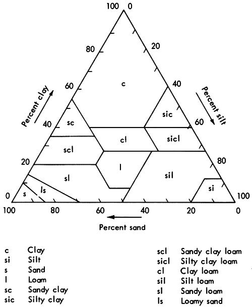
Verbal definitions (Soil Survey Staff, 1960) of soil textural classes, defined according to size distribution of mineral particles less than 2 mm in diameter, are as follows:
The need for fine distinctions in the texture of soil horizons causes a large number of soil textural classes (Soil Survey Staff, 1960). Often it is convenient to speak generally of a broad group of textural classes. An outline of acceptable general terms in relation to the basic soil textural class names, in three and five classes, follows:
| General terms | Textural class names | |
|---|---|---|
| Sandy soils | Coarse textured soils | |
| Sand | ||
| Loamy sand | ||
| Loamy soils | Moderately coarse textured soils | |
| Sandy loam | ||
| Fine sandy loam | ||
| Medium textured soils | ||
| Very fine sandy loam | ||
| Loam | ||
| Silt loam | ||
| Silt | ||
| Moderately fine textured soils | ||
| Clay loam | ||
| Sandy clay loam | ||
| Silty clay loam | ||
| Clayey soils | Fine textured soils | |
| Sandy clay | ||
| Silty clay | ||
| Clay | ||
Field determination of texture often differs from mechanical analyses of soil samples, even by experienced soil scientists. Often these field errors are due to content of organic matter, kind of clay, and size and shape of soil particles. Errors in laboratory analysis also may be due to dispersion differences, temperature variations, different methods of analysis, and other factors. Nevertheless, it is the duty of each soil scientist to adjust his judgments of field texture with familiar samples that have been analyzed in the laboratory.
The following definitions (Soil Survey Staff, 1960; Shaw, 1928) enable some judgment of the basic soil textural classes in terms of field experience and feel:
Coarse fragments (Soil Survey Staff, 1960) should be estimated for each soil horizon, as well as for the soil surface. Even estimates are not very reliable., and wherever necessary coarse fragments can be sampled, weighed, or volumes measured. Significant proportions of fragments coarser than very coarse sand and less than 10 inches (if rounded) or 15 inches along the longer axis (if flat) are recognized by an appropriate adjective in the textural soil class name. Such fragments are regarded as a part of the soil mass. They influence moisture storage, infiltration, and runoff. They influence root growth, especially through their dilution of the mass of active soil. They protect the fine particles from washing and blowing. They are moved with the soil mass in tillage.
Many names and standards have been proposed by geologists and soil scientists for these fragments. Fine distinctions are easily made, but not always easily mapped, because the fragments are easy to see; but finer distinctions than those set forth in Table 8 have little or no real significance to soil genesis or behavior. Other variables, like the mineralogy of the clays or the nature of the organic matter, are far more important. The scientist must guard against making finer distinctions among the coarse fragments than those of real significance, simply because he can see them easily in the field.
The accepted adjectives to include in textural soil class names and the size limits of classes of coarse fragments are set forth in outline form in Table 8. This Table includes the probable maximum of detail required for detailed basic soil surveys. In situations where no useful purpose is served by developing separate map units to indicate the separate classes, the classes are grouped and a name is given to the soil type or soil phase that most clearly indicates the situation. Thus a cobbly loam or a stony phase may include other fragments also listed in the two right hand columns. In this section only fragments smaller than stones are discussed.
The adjectives listed in the first two columns of Table 8 are incorporated into the soil textural class designations of horizons when the soil mass contains significant proportions of the fragments, above 15 to 20 percent by volume, depending upon the other soil characteristics. These class names become parts of soil type names. Where the coarse fragments make up 90 percent or more of the soil mass by volume in the upper eight inches, the land is classified in the appropriate miscellaneous land type. If necessary to make distinctions of clear significance, another subdivision can be made of the coarse fragments at about 50 percent to give, for example, gravelly loam (20-50 percent gravel) and very gravelly loam (50-90 percent gravel). The other defined fragments may be handled similarly.
Table 8--Names for coarse fragments in soils (Soil Survey Staff, 1960).
| Shape and kind of fragments |
Size and name of fragments | ||
|---|---|---|---|
| Up to 3 inches in diameter |
3-10 inches in diameter |
More than 10 in. in diameter |
|
| Rounded and subrounded fragments (all kinds of rock) |
Gravelly | Cobbly | Stony or bouldery* |
| Irregularly shaped angular fragments: | |||
| Chert | Cherty | Coarse cherty | Stony |
| Other than chert | Angular gravelly | Angular cobbly | Stony |
| Up to 6 inches in length |
6-15 inches in length |
More than 15 in. in length |
|
| Thin flat fragments: | |||
| Thin, flat sandstone, limestone, and schist |
Channery | Flaggy | Stony |
| Slate | Slaty | Flaggy | Stony |
| Shale | Shaly | Flaggy | Stony |
| *Bouldery is used where stones are larger than 24 inches. | |||
The recommended terms to apply to soil containing above 15 to 20 percent and less than 90 percent coarse fragments smaller than stones are defined as follows:
Stones larger than 10 inches in diameter and rock outcrops are not regarded as part of the soil mass as defined by soil textural classes (Soil Survey Staff, 1960). They have an important bearing on soil use, however, because of their interference with the use of agricultural machinery and their dilution of the soil mass. In fact, stoniness, rockiness, or both, are the differentiating criteria between classes of arable soil and between arable and nonarable soil in many places. In large part the soils developed from glacial till, for example, especially where the till is thin, have characteristics that make them highly responsive to management, except for stoniness. Soil scientists have sometimes neglected this factor, perhaps in part because it is a difficult problem to deal with in the field. Several otherwise useful published soil surveys have failed in their objectives because of the failure to establish meaningful classes of stoniness. Although detailed attention was given soil color, texture, geology, slope, erosion, depth, and the like, stoniness was so carelessly evaluated that the maps cannot be used to distinguish between potential cropland, pasture land, and forest land, in descending order of intensity.
The suggestions that follow differentiate between loose stones and fixed stones and provide classes within each as required in basic detailed surveys. Admittedly the suggestions are especially aimed to deal with the most complicated situations--where both loose stones and fixed stones exist and influence soil-use capability differently and where the soils are otherwise suitable for intensive use. Generally, loose stones are scattered over the soil, while rock ledges are more concentrated in strips with relatively rock-free soil between. Such situations are most common in glaciated regions with thin drift, as in New England and parts of the northern Lake States.
Outside the glaciated regions, loose stones are less abundant, although by no means uncommon. In some sections of the country, soils containing fixed stones (rocky soils as here defined), some loose fragments 3 to 10 inches in diameter, and some stones have been called stony for many years. Where no useful purpose is served by dividing into additional types and phases, it should not be done. Thus the classes proposed for stoniness and rockiness may be grouped in the definition of any individual map unit.
Stoniness (Soil Survey Staff, 1960) refers to the relative proportion of stones over 10 inches in diameter in or on the soil. The significance of a given number or amount of stones may depend upon the other soil characteristics. If a soil is exceedingly responsive to management for lawns or improved pasture, differences between even high degrees of stoniness are significant and may warrant separate map units, as for example an extremely stony phase of a soil type differentiated from the miscellaneous land type of stony land.
The limits of the classes of stoniness are defined broadly in absolute terms and more specifically in terms of soil use wherever the other soil characteristics are favorable for crops or improved pasture. The able soil classifier avoids fine distinctions according to stoniness where they are not significant as clearly as he recognizes them where they are significant. This mean.s that in the descriptive soil legend and in the soil survey report, stony phases need to be defined within the soil series and types. The classes of stoniness are used in definitions of all units of soil classification and may become one criterion for soil series as well as the sole criterion for distinctions among phases within the soil series or soil types.
Classes of stoniness are:
It should be emphasized that these classes are for general application in soil descriptions. They may or may not be used as phase distinctions. In other words a map unit may be defined in terms of more than one class of stoniness. Some individual soils may be defined in terms of classes of stoniness, classes of rockiness, and classes of coarse fragments. Stoniness is not a part of the soil textural class. The terms stony, very stony, or extremely stony may modify the soil textural class name in the soil type, but this is simply a brief way of designating stony phases. Soil series descriptions need to include the range of stoniness in terms of classes 0, 1, 2, and 3.
Rockiness (Soil Survey Staff, 1960) refers to the relative proportion of bedrock exposures, either rock outcrops or patches of soil too thin over bedrock for use, in a soil area (soil map unit). The word rocky is used arbitrarily for soils having fixed rock (bedrock). The word stony is used for soils having loose detached fragments of rock.
The classes of rockiness, as of stoniness, are given broad definitions in absolute terms and more specific definitions in terms of soil use for those soils otherwise suitable for crops or improved pasture. Soil areas having the same definitions in terms of area of bedrock exposure may vary widely in the depth of soils between the rock outcrops. Such distinctions need to be made within the soil series definitions and map unit descriptions. As with stoniness, the classes of rockiness are used in soil series descriptions and can become one criterion for series distinctions or the sole criterion for phase distinctions. Two or more classes may be combined in one map unit. Some map units may also have classes of stoniness and of coarse fragments.
The relationships to soil use suggested in the definitions of the classes apply mainly to areas of soil in humid regions that are otherwise responsive to management. The definitions of actual soil phases must take account of the alternative management practices that can be used for seeding, harvesting, weed control, and the like.
In each descriptive legend and soil survey report, rocky phases need to be defined specifically within each soil map unit and soil type.
The classes of rockiness are:
Soil structure (Soil Survey Staff, 1960) refers to the aggregation of primary soil particles into compound particles, or clusters of primary particles, which are separated from adjoining aggregates by surfaces of weakness. The exteriors of some aggregates have thin, often dark colored, surface films which perhaps help to keep them apart. Other aggregates have surfaces and interiors of like color, and the forces holding the aggregates together appear to be wholly internal. Appendix Table 6 lists terms used to describe soil structure, and Appendix Figures 13-16 give size limits for different types of structure.
An individual natural soil aggregate is called a ped, in contrast to:
The importance of soil structure in soil classification and in influencing soil productivity can scarcely be overemphasized. The capability of any soil for the growth of plants and its response to management depends as much on its structure as on its fertility. Generally, in the United States, soils with aggregates of spheroidal shape have much pore space between aggregates, have more rapid permeability, and are more productive than soils of comparable fertility that are massive or even coarsely blocky or prismatic. In other parts of the world, some soils are overgranulated. Some soils in the tropics have such well-developed spheroidal peds that the moisture holding capacity is low, too few contacts exist between roots and soil, and as a consequence the soils are relatively unproductive.
Field descriptions of soil structure note:
Field terminology for structure consists of separate sets of terms designating each of these three qualities, which by combination form the names for structure. Shape and arrangement of peds are designated as type of soil structure; size of peds, as class; and degree of distinctness, as grades (Nikiforoff, 1941). The structural pattern of a soil horizon also includes the shapes and sizes of pore spaces as well as those of the peds themselves.
There are four primary types of structure (Soil Survey Staff, 1960):
Each of the last three types have two subtypes. Under prismlike the subtypes are prismatic (without rounded upper ends) and columnar (with rounded caps). The subtypes of blocklike are angular blocky (bounded by planes intersecting at relatively sharp angles) and subangular blocky (having mixed rounded and plane faces with vertices mostly rounded). If the term blocky is used alone, angular blocky is understood. Spheroidal is subdivided into granular (relatively nonporous) and crumb (very porous). Each type of structure includes peds that vary in shape, and detailed soil descriptions may require supplemental statements about the shape of the individual peds.
The names in the preceding paragraph placed in italics are the terms most used in descriptions of soil horizons. The word nut has been used for blocklike peds, but is not recommended; the word nuciform has been an optional alternative for subangular blocky, but subangular blocky is recommended. It is difficult for many to dissociate a size connotation from terms like nut and nuciform. For this reason some confuse very fine blocky with granular. Terms used to designate types of soil structure refer only to shape and arrangement and do not specify size.
Five size classes are recognized in each of the primary types. The names of these and their size limits, which vary with the four primary types for shape and arrangement, are given in Table 9.
Table 9--Types and classes of soil structure (Soil Survey Staff, 1960).
| Class | Type (Shape and arrangement of peds) | ||||||
|---|---|---|---|---|---|---|---|
| Platelike with one dimension (the vertical) limited and greatly less than the other two; arranged around a horizontal plane; faces mostly horizontal. | Prismlike with two dimensions (the horizontal) limited and considerably less than the vertical; arranged around a vertical line; vertical faces well defined; vertices angular. | Blocklike, polyhedronlike, or spheroidal, with three dimensions of the same order of magnitude, arranged around a point. | |||||
| Blocklike; blocks or polyhedrons having plane or curved surfaces that are casts of the molds formed by the faces of the surrounding peds. | Spheroids or polyhedrons having plane or curved surfaces which have slight or no accommodation to the faces of surrounding peds. | ||||||
| Without rounded caps | With rounded caps | Faces flattened; most vertices sharply angular | Mixed rounded and flattened faces with many rounded vertices | Relatively non-porous peds | Porous peds | ||
| Platy | Prismatic | Columnar | Angular blocky | Subangular blocky | Granular | Crumb | |
| Very fine or very thin | Very thin platy; thinner than 1 mm | Very fine prismatic; diameter less than 10 mm | Very fine columnar; diameter less than 10 mm | Very fine angular blocky; less than 5 mm | Very fine subangular blocky; less than 5 mm | Very fine granular; less than 1 mm | Very fine crumb; less than 1 mm |
| Fine or thin | Thin platy; 1-2 mm | Fine prismatic; 10-20 mm | Fine columnar; 10-20 mm | Fine angular blocky; 5-10 mm | Fine subangular blocky; 5-10 mm | Fine granular; 1-2 mm | Fine crumb; 1-2 mm |
| Medium | Medium platy; 2-5 mm | Medium prismatic; 20-50 mm | Medium columnar; 20-50 mm | Medium angular blocky; 10-20 mm | Medium subangular blocky; 10-20 mm | Medium granular; 2-5 mm | Medium crumb; 2-5 mm |
| Coarse or thick | Thick platy; 5-10 mm | Coarse prismatic; 50-100 mm | Coarse columnar; 50-100 mm | Coarse angular blocky; 20-50 mm | Coarse subangular blocky; 20-50 mm | Coarse granular; 5-10 mm | |
| Very coarse or very thick | Very thick platy; thicker than 10 mm | Very coarse prismatic; diameter more than 100 mm | Very coarse columnar; diameter more than 100 mm | Very coarse angular blocky; more than 50 mm | Very coarse subangular blocky; more than 50 mm | Very coarse granular; more than 10 mm | |
Grade of structure is the degree of aggregation and expresses the differential between cohesion within aggregates and adhesion between aggregates. In field practice, grade of structure is determined mainly by noting the durability of the aggregates and the proportions between aggregated and unaggregated material that result when the aggregates are displaced or gently crushed. Grade of structure varies with the moistening of the soil and should be described at the most important moisture contents of the soil horizon. The principal description of the structure of a soil horizon should refer to its normal moisture content, although attention should be called to any striking contrasts in structure under other moisture conditions to which the soil is subject. If grade is designated at an unstated moisture content, it is assumed that the soil is nearly dry or only very slightly moist, which is commonly that part of the range in soil moisture in which soil structure is most strongly expressed.
With exposure, structure may become much altered, often much stronger. Old road cuts are not suitable places to determine the grade of structure, but they often offer a clue to the type of structure present where the grade is so weak that it cannot be identified in the undisturbed soil.
Terms for grade of structure are as follows:
The sequence followed in combining the three terms to form the compound name of the structure is:
For example, the designation for the soil structure in which the peds are loosely packed and roundish but not extremely porous, dominantly between 1-2 mm in diameter, and quite distinct is strong fine granular. The designation of structure by grade, class, and type can be modified with other appropriate terms wherever necessary to describe other characteristics of the peds.
Many soil horizons have compound structure consisting of one or more sets of smaller peds held together as larger peds. Compound structures are described, for example, as compound moderate very coarse prismatic and moderate medium granular. Soil that has one structural form when in place may assume some other form when disturbed. When removed, the larger peds may fall into smaller peds, such as large prisms into medium blocks.
With increasing disturbance or pressure any aggregate breaks into smaller particles. These finer particles may or may not be peds, depending on whether their form and size are determined by surfaces of weakness between natural aggregates or by the place and direction of the pressures applied. Mere breakage into fragments larger than the soil grains without some orderly shape and size should not be confused with soil structure. Massive soil horizons, without structure, can be shattered into fragments--like broken glass. Such fragments are not peds.
Soil consistence (Soil Survey Staff, 1960) comprises the attributes of soil material that are expressed by the degree and kind of cohesion and adhesion or by the resistance to deformation or rupture. Appendix Tables 7 and 8 list and describe terms for consistence of soil horizons. Every soil material has consistence irrespective of whether the mass be large or small, in a natural condition or greatly disturbed, aggregated or structureless, moist or dry. Although consistence and structure are interrelated, structure deals with the shape, size, and definition of natural aggregates that result from variations in the forces of attraction within a soil mass, whereas consistence deals with the strength and nature of such forces themselves. Soil consistence is closely related to the Atterberg limits, and is particularly critical for engineering uses of soils (Olson, 1972; Soil Survey Staff, 1971).
The terminology for consistence includes separate terms for description at three standard moisture contents (dry, moist, and wet). If moisture conditions are not stated in using any consistence term, the moisture condition is that under which the particular term is defined. Thus, the word friable used without statement of the moisture content specifies friable when moist; the word hard used alone means hard when dry; and the word plastic used alone means plastic when wet. If a term is used to describe consistence at some moisture content other than the standard condition under which the term is defined, a statement of the moisture condition is essential. Usually it is unnecessary to describe consistence at all three standard moisture conditions. The consistence when moist is commonly the most significant, and a soil description with this omitted is not complete; the consistence when dry is generally useful but may be irrelevant in descriptions of soil materials that are never dry; and the consistence when wet is unessential in the description of many soils but extremely important in some.
Although evaluation of consistence involves some disturbance, unless otherwise stated the descriptions of consistence customarily refer to that of soil from undisturbed horizons. In addition, descriptions of consistence under moist or wet conditions carry an implication that disturbance causes little modification of consistence or that the original consistence can be almost restored by pressing the material together. Where such an implication is misleading, as in compacted layers, the consistence both before and after disturbance may require separate description. Also compound consistencies occur, as in a loose mass of hard granules. In a detailed description of soils having compound structure, the consistence of the mass as a whole and of its parts should be stated.
A number of terms, including brittle, crumbly, dense, elastic, fluffy, mealy, mellow, soft, spongy, stiff, tight, tough, and some others, which have often been used in description of consistence, are not here defined. These are all common words with well-known meanings. Some are indispensable for describing unusual conditions not covered by other terms. They are useful in nontechnical descriptions where a little accuracy may be sacrificed to use a term familiar to lay readers. Whenever needed, these or other terms for consistence not here defined should be employed with meanings as given in standard dictionaries.
The terms used in soil descriptions for consistence follow.
The consistence of soil materials (Soil Survey Staff, 1960) when dry is characterized by rigidity, brittleness, maximum resistance to pressure, more or less tendency to crush to a powder or to fragments with rather sharp edges, and inability of crushed material to cohere again when pressed together. To evaluate, select an air-dry mass and break in the hand.
Consistence when moist (Soil Survey Staff, 1960) is determined at a moisture content approximately midway between air dry and field capacity. At this moisture content most soil materials exhibit a form of consistence characterized by:
The resistance decreases with moisture content, and accuracy of field descriptions of this consistence is limited by the accuracy of estimating moisture content. To evaluate this consistence, select and attempt to crush in the hand a mass that appears slightly moist.
The term compact denotes a combination of firm consistence and close packing or arrangements of particles and should be used only in this sense. It can be given degrees by use of the adjectives very and extremely.
Consistence when wet (Soil Survey Staff, 1960) is determined at or slightly above field capacity.
Cementation of soil material refers to a brittle hard consistence caused by some cementing substance other than clay minerals, such as calcium carbonate, silica, or oxides or salts of iron and aluminum. Typically the cementation is altered little if any by moistening; the hardness and brittleness persist in the wet condition. Semireversible cements, which generally resist moistening but soften under prolonged wetting, occur in some soils and give rise to soil layers having a cementation that is pronounced when dry but very weak when wet. Some layers cemented with calcium carbonate soften somewhat with wetting. Unless stated to the contrary, descriptions of cementation imply that the condition is altered little if any by wetting. If the cementation is greatly altered by moistening, it should be so stated. Cementation may be either continuous or discontinuous within a given horizon.
The intensity of soil acidity or alkalinity (Soil Survey Staff, 1951) is expressed in pH--the logarithm of the reciprocal of the H+ ion concentration. With this notation, pH 7 is neutral; lower values indicate acidity; and higher values show alkalinity. Soil horizons vary in pH from about 3 to about 10. The corresponding terms used for pH ranges in soils are:
| Term | pH range |
|---|---|
| Extremely acid | Below 4.5 |
| Very strongly acid | 4.5-5.0 |
| Strongly acid | 5.1-5.5 |
| Medium acid | 5.6-6.0 |
| Slightly acid | 6.1-6.5 |
| Neutral | 6.6-7.3 |
| Mildly alkaline | 7.4-7.8 |
| Moderately alkaline | 7.9-8.4 |
| Strongly alkaline | 8.5-9.0 |
| Very strongly alkaline | 9.1 and higher |
Colorimetric methods (Reed and Cummings, 1945) are generally used for determining pH of soil in the field. These methods use indicator dyes with a small sample of soil on a spot plate. The reagent color, when reacted with soil, is compared with color standards on a color chart. These methods give satisfactory results on mineral soils between about pH 4.5 and pH 7.5. An experienced soil tester should expect results within 0.2 to 0.4 units of the pH values determined electrometrically. Common specific indicators used in the field and their pH ranges are:
| Indicator | pH range |
|---|---|
| Bromcresol green | 3.8-5.6 |
| Chlorphenol red | 5.2-6.8 |
| Bromthymol blue | 6.0-7.6 |
| Phenol red | 6.8-8.4 |
| Cresol red | 7.2-8.8 |
| Thymol blue | 8.0-9.6 |
The presence of free carbonates in the soil may be tested with 10 percent hydrochloric acid. Effervescence indicates CO2 in the reaction:
CaCO3 + 2HCl → CO2↑ + CaCl2 + H2O
Soil horizon boundaries (Soil Survey Staff, 1962) vary in:
Some boundaries are clear and sharp while others are diffuse (gradually merging into one another). With diffuse horizons, the location of the boundary requires time-consuming comparisons of small samples of soil from various parts of the profile until the midpoints are established. Small markers can be inserted until all horizons of the profile are designated; then measurements can be taken; and finally the individual horizons can be described and sampled.
The distinction of the horizons to the observer depends partly upon the contrast between them--some adjacent ones are highly contrasting in several features--and partly upon the width of the boundary itself or the amount of the profile in the transition between one horizon and the next. The characteristic widths of boundaries between soil horizons may be described as:
The topography of different soil horizons varies, as well as their distinctness. Although observations of soil horizons are made in profiles or sections, and so photographed or sketched, they are not bands or literal horizons but rather three-dimensional parts of pedons that may be smooth or exceedingly irregular. Horizon boundaries may be described as:
The lower boundary of each horizon in a soil profile is conventionally described as part of that horizon description.
Alluvium--Silty stream deposits made during flood stage overflow of normal channels.
Bisequal--Two sequences of A and B horizons.
Chernozem--A grassland soil.
Eluvial--Leached.
Fragipan--A dense hardpan.
Genetic--Soil or soil characteristic formed by alteration of original geologic material.
Gley--Reduced gray soil due to poor drainage and high water table.
Horizon--A soil layer roughly parallel with the soil surface. The various horizons, considered together, make up the soil profile.
Illuvial--Deposited by leaching from soil horizons above.
Lacustrine--Usually clayey deposits made in still water at the bottom of a lake.
Loess--Silty material deposited by blowing wind.
Morphology--The characteristics of a soil profile.
Mottled--Spots of red, orange, brown, and/or yellow colors in soil due to poor drainage.
Parent material--Altered geologic material from which the soil is presumed to have formed.
Ped--A natural aggregate of soil.
Pedogenic--Soil characteristic caused by the soil forming processes.
Pedon--A small area of soil having the same soil profile or cyclic repetition of variations for one soil.
SCS--Soil Conservation Service.
Sequum--An A-B horizon sequence.
Sesquioxides--Al2O3 and Fe2O3.
Soil profile--A vertical cut exposing the various parts and characteristics of a soil with depth.
Solum--That part of a soil profile including the A and B horizons.
Truncated--A scalped soil profile, with part missing due to erosion or a geologic catastrophe.
USDA--United States Department of Agriculture.
Brewer, R. and J. R. Sleeman. 1963. Pedoturbules: their definition, classification, and interpretation. J. Soil Sci. 14:156-166.
Clarke, G. R. 1957. The study of the soil in the field. Fourth edition. Clarendon Press. Oxford, England.
Cline, M. G. 1963. Soils and soil associations of New York. Cornell Extension Bulletin 930.
Cline, M. G. 1964. Lecture notes and class outlines for courses on soil morphology, genesis, classification, and mapping at Cornell University. (Mimeographed).
Folk, R. L. 1951. A comparison chart for visual percentage estimation. J. Sed. Petrology 21:32-33.
Jha, P. P. and M. C. Cline. 1963. Morphology and genesis of a Sol Brun Acide with fragipan in uniform silty material. Soil Sci. Soc. Am. Proc. 27:339-344.
Kilmer, V. J. and L. T. Alexander. 1949. Methods of making mechanical analysis of soils. Soil Sci. 68:15-24.
Low, A. J. 1954. The study of soil structure in the field and the laboratory. J. Soil Sci. 5:57-74.
Munsell Color Company. 1954. Munsell soil color charts. 2441 North Calvert Street, Baltimore 18, Maryland.
Nikiforoff, C. C. 1936. Method of recording soil data. Soil Sci. Soc. Am. Proc. 1:307-317.
Nikiforoff, C. C. 1941. Morphological classification of soil structure. Soil Sci. 52:193-212.
Nikol'skii, N. N. 1959. Practical soil science. Translated from Russian by Israel Program for Scientific Translations, Jerusalem, 1963. Available from the Office of Technical Services, U.S. Dept. of Commerce, Washington 25, D.C.
Olson, G. W. 1964. Application of soil survey to problems of health, sanitation, and engineering. Memoir 387. Cornell University, Ithaca, New York.
Olson, G. W. 1972. Engineering interpretations for uses of soils in developing countries. Agronomy Mimeo 72-14. Cornell University, Ithaca, New York. Also published by Food and Agriculture Organization of the United Nations (Rome) as Soils Bulletin 19 ( 1973).
Olson, G. W. 1974. Using soils of Kansas for waste disposal: a first approximation for solution to the problems and a guide to further interdisciplinary efforts. Bulletin 208, Kansas Geological Survey, The University of Kansas, Lawrence. [available online]
Reed, G. F. and R. W. Cummings. 1945. Soil reaction: glass electrode and colorimetric methods for determining pH values of soils. Soil Sci. 59:97-104.
Shaw, C. F. 1928. A definition of terms used in soil literature. First Int. Cong. Soil Sci. Proc. and Papers 5:38-64. Washington, D.C.
Simonson, R. W. 1951. Description of mottling in soils. Soil Sci. 7:187-192.
Simonson, R. W. 1954. Morphology and classification of the Regur soils of India. J. Soil Sci. 5:275-288.
Smyth, A. J. 1965 (approximately). Guidelines for soil profile description. Food and Agriculture Organization of the United Nations, Rome, Italy.
Soil Survey Staff. 1951. Soil survey manual. U.S. Dept. Agr. Hdbk 18. U.S. Gov't Print. Off. Washington, D.C.
Soil Survey Staff. 1960. Soil classification: a comprehensive system-the seventh approximation. U.S. Gov't Print. Off. Washington, D.C.
Soil Survey Staff. 1962. Supplement to soil survey manual (Agr. Hdbk 18) replacing pages 173-188. U.S. Gov't Print. Off. Washington, D.C.
Soil Survey Staff. 1970. Selected chapters from the unedited text of the Soil Taxonomy of the National Cooperative Soil Survey. Soil Conservation Service, U.S. Department of Agriculture, Washington, D.C.
Soil Survey Staff. 1971. Guide for interpreting engineering uses of soils. U.S. Gov't Print. Off. Washington, D. C.
Soil Survey Staff. 1973. Soil taxonomy: a basic system of soil classification for making and interpreting soil surveys-preliminary, abridged text. Soil Conservation Service, U.S. Department of Agriculture, Washington, D.C.
Swanson, D. W. 1973. Pedon coding system for the National Cooperative Soil Survey. Soil Conservation Service, U.S. Department of Agriculture, Washington, D.C.
Taylor, N. H. and I. J. Pohlen. 1962. Soil survey method: a New Zealand handbook for the field study of soils. New Zealand Soils Bureau Bull. 25. Soil Bureau, New Zealand Dept. of Scientific and Industrial Research, Taita Expt. Sta., Lower Hutt, New Zealand.
Tomasu, B. I. and W. E. Roth. 1968. Soil survey of Grant County, Kansas. U.S. Gov't Print. Off. Washington, D.C.
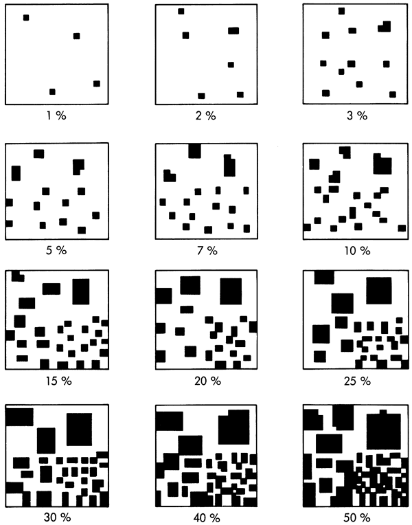
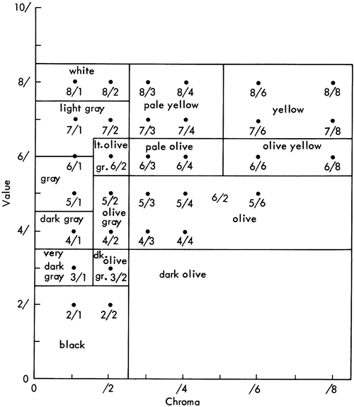
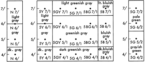
Kansas Geological Survey, Criteria for Making and Interpreting A Soil Profile Description
Placed on web Aug. 11, 2009; originally published in 1976.
Comments to webadmin@kgs.ku.edu
The URL for this page is http://www.kgs.ku.edu/Publications/Bulletins/212/index.html