Kansas Geological Survey, Bulletin 187, Part 5, originally published in 1967
Originally published in 1967 as Kansas Geological Survey Bulletin 187, Part 5. This is, in general, the original text as published. The information has not been updated.
Clay mineralogy, sedimentary parameters, and heavy mineral content of Pleistocene alluvial terrace (Illinoisan) and flood-plain (Wisconsinan) deposits of the Neosho River valley in southeastern Kansas were investigated. The clay mineral assemblage of the alluvial deposits consists of montmorillonite, a 14Å mixed-layer mineral, illite, and kaolinite. Montmorillonite is the dominant clay mineral in alluvial terrace deposits; illite and kaolinite are variable in proportion. Flood-plain deposits contain montmorillonite, illite, and kaolinite in decreasing order of relative abundance. The diffraction-intensity ratio, derived from X-ray diffraction intensities of illite and kaolinite, is significantly different for alluvial terrace and flood-plain deposits. Relative abundances of clay minerals in each deposit are evaluated in terms of (1) contribution of the source area, (2) weathering, (3) time, (4) topography, and (5) drainage.
Grain-size analyses of alluvial terrace and flood-plain deposits did not reveal a significant difference in parameters such as phi-median and phi-sorting. Alluvial terrace deposits, however, showed greater variation in sorting than the flood-plain deposits. Variation in sorting is not sufficiently marked to be used as a criterion to differentiate terrace deposits from flood-plain deposits.
The heavy mineral assemblage of terrace and flood-plain deposits consists of zircon, tourmaline, staurolite, garnet, topaz, and magnetite. Flood-plain deposits contain minor amounts of epidote and kyanite, which are rare or absent in terrace deposits.
The Neosho River valley in southeastern Kansas (Labette and Cherokee counties) is characterized by topographically high undulating terraces, which locally are adjacent to nearly flat-lying alluvial flood plains. The terraces have been attributed to alluvial deposition during the Illinoisan Stage, whereas adjacent flood plains were formed by alluviation during the Wisconsinan Stage. Detritus composed of gravel, sand, silt, and clay was derived from Permian and Pennsylvanian deposits into which the Neosho River is entrenched. In the area studied, Wisconsinan-Illinoisan deposits overlie the Cabaniss Formation (Cherokee Group, Middle Pennsylvanian) and range in thickness from 9 to 34 feet. Alluvial terrace and flood-plain deposits in Kansas have been discussed by Frye and Leonard (1952); alluvial deposits of the Neosho River valley have not been investigated previously in detail.
The objective of this report is to differentiate alluvial terrace deposits (Illinoisan) from deposits underlying the flood plain (Wisconsinan) on the basis of their sedimentary characteristics. Characteristics compared are clay mineralogy, grain-size parameters, and heavy mineral content.
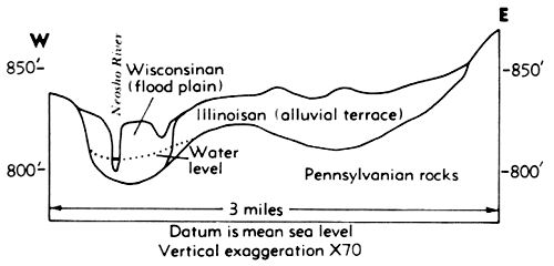
The area studied is shown in Figure 1, and a generalized cross section of the Neosho River valley is shown in Figure 2.
Figure 1--Map of Labette and Cherokee counties showing locations of sampling. (Sample no. 12, not shown on figure, is located in NN NE sec. 16, T 31 S, R 21 E.)
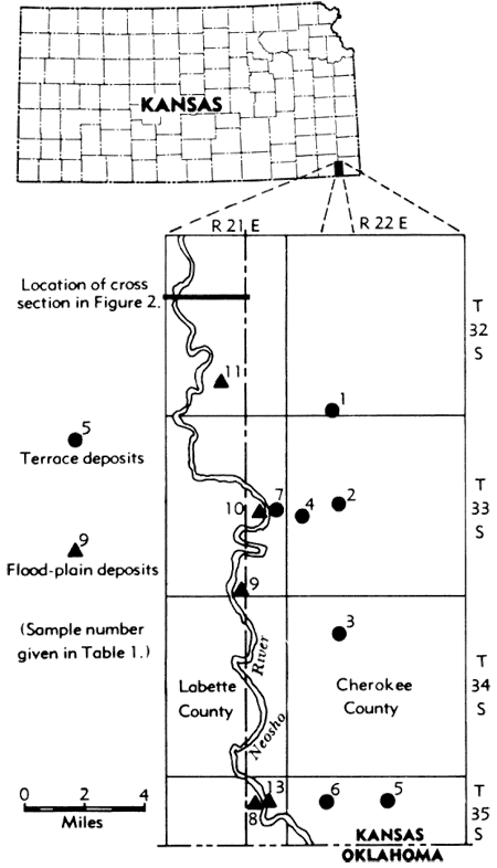
Figure 2--Generalized cross section of the Neosho River valley.
In 1964 samples were obtained by drilling test holes in the Neosho River valley in Cherokee and Labette counties (Fig. 1, Table 1).
Table 1--List of sample locations.
| Alluvial terrace deposits | ||
|---|---|---|
| Sample no. | Location | Depth, feet |
| 1a | SE SW sec. 32, T 32 S, R 22 E | 0-4 |
| 1b | SE SW sec. 32, T 32 S, R 22 E | 6-8 |
| 2a | SE SE sec. 17, T 33 S, R 22 E | 0-2 |
| 2b | SE SE sec. 17, T 33 S, R 22 E | 6-8 |
| 2c | SE SE sec. 17, T 33 S, R 22 E | 18-20 |
| 3a | NE NE sec. 8, T 34 S, R 22 E | 2-4 |
| 3b | NE NE sec. 8, T 34 S, R 22 E | 6-8 |
| 3c | NE NE sec. 8, T 34 S, R 22 E | 14-18 |
| 4a | NE NW sec. 19, T 33 S, R 22 E | 0-2 |
| 4c | NE NW sec. 19, T 33 S, R 22 E | 18-20 |
| 5a | SE SW sec. 3, T 35 S, R 22 E | 0-2 |
| 5b | SE SW sec. 3, T 35 S, R 22 E | 6-8 |
| 5c | SE SW sec. 3, T 35 S, R 22 E | 13-14 |
| 5d | SE SW sec. 3, T 35 S, R 22 E | 18-20 |
| 5e | SE SW sec. 3, T 35 S, R 22 E | 26-27 |
| 6a | SE SW sec. 5, T 35 S, R 22 E | 0-2 |
| 6b | SE SW sec. 5, T 35 S, R 22 E | 6-8 |
| 7 | NE NE sec. 24, T 33 S, R 21 E | 0-29 |
| Flood-plain deposits | ||
| Sample no. | Location | Depth, feet |
| 8a | SW SW sec. 1, T 35 S, R 21 E | 0-2 |
| 8b | SW SW sec. 1, T 35 S, R 21 E | 8-10 |
| 8c | SW SW sec. 1, T 35 S, R 21 E | 12-14 |
| 8d | SW SW sec. 1, T 35 S, R 21 E | 16-18 |
| 9a | SW SE sec. 35, T 33 S, R 21 E | 0-2 |
| 9b | SW SE sec. 35, T 33 S, R 21 E | 6-8 |
| 10a | NW NW sec. 24, T 33 S, R 21 E | 0-2 |
| 10b | NW NW sec. 24, T 33 S, R 21 E | 6-8 |
| 10c | NW NW sec. 24, T 33 S, R 21 E | 18-20 |
| 11a | SE SE sec. 27, T 32 S, R 21 E | 0-2 |
| 11b | SE SE sec. 27, T 32 S, R 21 E | 12-14 |
| 11c | SE SE sec. 27, T 32 S, R 21 E | 18-20 |
| 12a | NE NE sec. 16, T 31 S, R 21 E | 0-2 |
| 12b | NE NE sec. 16, T 31 S, R 21 E | 12-14 |
| 13 | SE SW sec. 1, T 35 S, R 21 E | 0-21 |
Identification of clay minerals was based primarily on X-ray diffraction of oriented <2 μ clay particles sedimented onto glass slides. A Phillips Norelco X-ray unit was used with nickel-filtered copper radiation. Each sample was X-rayed under the following conditions: (1) air dried, (2) glycerated, (3) heated to 450°C, and (4) heated to 575°C for 30 minutes. Diffraction intensity (counts per second) of (001) basal reflections above the background was used as an approximation of the relative abundances of montmorillonite, 14Å mixed-layer clay mineral, illite, and kaolinite.
The diffraction-intensity (D.I.) ratio, derived by dividing the X-ray diffraction intensity (counts per second) of the 10Å spacing for illite by the intensity of the 7Å spacing of kaolinite was found to be useful. The D.I. ratio was used previously in a similar study by Frye, et al. (1962).
X-ray data were supplemented by differential thermal analysis using the differential thermal apparatus in the Ceramics Division of the Kansas Geological Survey. The rate of heating was 10°C per minute.
Particle-size distribution of 25 samples (12 flood-plain and 13 alluvial terrace deposits) was determined by mechanical sieving and pipette methods. Calgon was used as a dispersing agent.
Heavy mineral separations for the silt fraction of 10 samples (five flood-plain and five terrace-deposit) were made using commercial bromoform as the heavy liquid. Heavy mineral assemblages were identified by comparison with known standard heavy minerals mounted on glass slides, using binocular and petrographic microscopes.
The Illinoisan terrace deposits, generally cream-colored and partially indurated, are composed of clay, silt, sand, and gravel. The gravel, mostly composed of chert pebbles, is in a layer directly overlying shale of the Cabaniss Formation. At the localities sampled the deposits range in thickness from 16 to 34 feet. Finely divided mica and iron oxide are disseminated through the silt and sand fractions of the deposits.
The Wisconsinan flood-plain deposits, generally brownish-gray, are unconsolidated and friable enough to be disaggregated by moderate shaking in water. The deposits are composed of clay, silt, sand, and gravel. The gravel, composed of chert pebbles, occurs at the bottom of the unconsolidated sediments and directly overlies the Cabaniss Formation. Iron-oxide staining of sand and silt particles, disseminated mica, and presence of organic material are common. The thickness of the deposits ranges from 19 to 34 feet.
Clay minerals in the fraction finer than 2 μ, as shown by X-ray diffraction patterns, are montmorilonite, kaolnite, and a 14Å mixed-layer mineral. Nature of the 14Å mixed-layer mineral could not be determined from the diffractometer patterns. The 14.7Å 10, and 7A basal reflections are sharp and well defined. Treatment with glycerine causes a shift in the 14.7Å (001) reflection to 18Å, accompanied by the appearance of (002) reflection at 9Å, whereas 10, 7, 4.9, 3.5, and 3.3Å reflections remain unaffected, except for a slight modification in peak intensities. With the exception of the 14.7Å peak, all other peaks are not modified by heating the sample to 450°C; however, heating to 575°C for 30 minutes resulted in destruction of all but the 10Å reflections.
X-ray diffractometer patterns for the alluvial terrace deposits and for the flood-plain deposits show differences in relative peak intensities of illite and kaolinite (Fig. 3). The diffraction intensities (counts per second) of montmorillonite and 14Å mixed-layer mineral, illite, and kaolinite, and the numerical value of D.I. ratios of illite and kaolinite for both deposits are shown in Tables 2 and 3.
Figure 3--X-ray diffractometer patterns characteristic of terrace and flood-plain clay minerals.
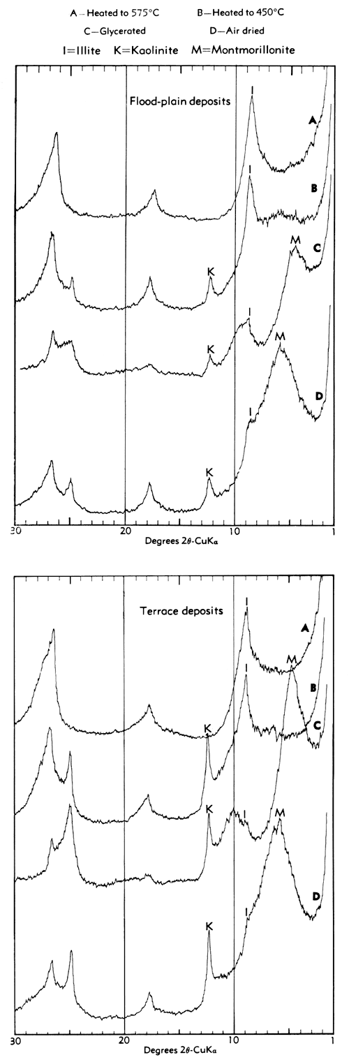
Table 2--X-ray analysis of clay minerals in alluvial terrace deposits.
| Sample no. |
Diffraction intensity (counts per second) |
D.I. | Depth, feet |
||
|---|---|---|---|---|---|
| Montmorillonite and mixed-layer mineral |
Illite | Kaolinite | Illite/kaolinite | ||
| 1a | 133 | 73 | 66 | 1.10 | 0-4 |
| 1b | 172 | 72 | 88 | 0.81 | 6-8 |
| 2a | 128 | 64 | 52 | 1.23 | 0-2 |
| 2b | 440 | 112 | 60 | 1.86 | 6-8 |
| 3a | 188 | 98 | 88 | 1.09 | 2-4 |
| 4a | 144 | 68 | 40 | 1.70 | 0-2 |
| 4c | 232 | 100 | 40 | 2.5 | 18-20 |
| 5b | 228 | 96 | 120 | 0.80 | 6-8 |
| 5c | 264 | 92 | 120 | 0.76 | 13-14 |
| 5d | 148 | 68 | 36 | 1.89 | 18-20 |
| 6b | 256 | 64 | 36 | 1.80 | 6-8 |
Table 3--X-ray analysis of clay minerals in flood-plain deposits.
| Sample no. |
Diffraction intensity (counts per second) |
D.I. | Depth, feet |
||
|---|---|---|---|---|---|
| Montmorillonite and mixed-layer mineral |
Illite | Kaolinite | Illite/kaolinite | ||
| 8a | 216 | 108 | 48 | 2.25 | 0-2 |
| 8b | 316 | 130 | 72 | 1.80 | 8-10 |
| 8d | 344 | 104 | 52 | 2.0 | 16-18 |
| 9a | 280 | 116 | 60 | 1.92 | 0-4 |
| 10a | 60 | 48 | 24 | 2.0 | 0-2 |
| 10b | 320 | 136 | 14 | 3.09 | 6-8 |
| 10c | 352 | 128 | 48 | 2.68 | 18-20 |
| 11a | 268 | 120 | 58 | 2.06 | 0,-2 |
| 11c | 292 | 107 | 40 | 2.67 | 18-20 |
| 12a | 240 | 112 | 52 | 2.16 | 0-2 |
| 12b | 213 | 116 | 48 | 2.42 | 12-14 |
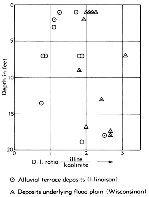
A plot of the D.I. ratio for illite to kaolinite versus depth for the alluvial terrace and flood-plain samples is shown in Figure 4. No systematic variation of the D.I. illite/kaolinite ratio occurs with depth. D.I. illite/kaolinite ratios for the samples from flood-plain deposits, however, are generally higher than those for the alluvial terrace deposits. The observed difference in the mean ratio of the D.I. illite/kaolinite of terrace and flood-plain samples is significant at the 0.01 significance level, using a t-test with 20 degrees of freedom.
Figure 4--Variation of D.I. ratio illite/kaolinite with depth (flood-plain and terrace deposits).
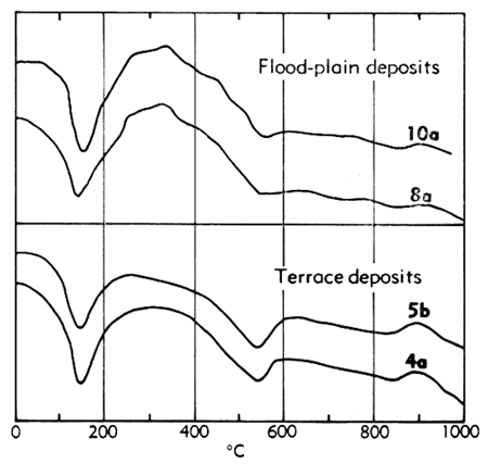
Purpose of differential thermal analysis (D.T.A.) was to substantiate information on the clay minerals. Four samples, two each from the terrace and flood-plain deposits, were analyzed by D.T.A. D.T.A. curves for the two types of deposits are shown in Figure 5. Endothermic peaks of montmorillonite, illite, and kaolinite are well defined. The kaolinite endothermic peak (500°-600°C) is subdued in the D.T.A. curve of the flood-plain deposits. In contrast, the kaolinite endothermic peak (500°-600°C) for the terrace deposits is relatively sharp. Irregularities in the D.T.A. curve for the flood-plain deposits, between the initial illite-montmorillonite endothermic peak (100°-250°C) and the 500°-600°C endothermic peak, are due to exothermic reactions of organic material. The same portion of the D.T.A. curve of the terrace deposits is relatively smooth.
D.T.A. did not reveal the nature of the 14Å mixed-layer mineral.
Figure 5--Differential thermal curves characteristic of terrace and flood-plain deposits.
Montmorillonite is dominant in the alluvial terrace deposits, illite and kaolinite being variable in proportion. The alluvial terrace deposits show a greater abundance of kaolinite as compared to its abundance in flood-plain deposits. Illite, however, is more abundant, relative to kaolinite in the flood-plain deposits. The flood-plain deposits have the following clay-mineral composition in order of relative basal diffraction intensities: Montmorillonite, illite, and kaolinite.
Although. there is disagreement regarding factors that influence clay-mineral assemblages, the following are considered important: (1) source area, (2) weathering, (3) time, (4) topography, and (5) drainage.
Montmorillonite in both types of alluvial deposits probably was contributed by the erosion of Permian and Pennsylvanian rocks. The abundance of montmorillonite in alluvial deposits has been attributed to the sedimentation processes by Jackson (1957).
The terrace deposits (Illinoisan) perhaps do not differ much in genesis from the flood-plain deposits (Wisconsinan). Both seem to have been formed by similar processes, within similarly positioned drainage basins, at different times. Therefore, it seems doubtful that the difference in the relative abundance of kaolinite and illite is inherent, because the source area for both deposits probably was the same. Contribution from the source area may have varied to some extent, however, because during the Wisconsinan glaciation, in contrast to Illinoisan glaciation, the valley was incised to a lower level, exposing older Permian and Pennsylvanian rocks that were then contributed to the alluvial fill by weathering processes. The greater proportion of illite in the flood-plain deposits probably is due to the weathering of the Pennsylvanian and Permian shales.
A reasonable explanation for the differences between the illite-kaolinite abundance perhaps could be found in the post-depositional history of these deposits. Factors such as weathering, time, topography, and drainage are considered important post-depositional modifiers of the clay-mineral assemblages.
It is suggested that the higher proportion of kaolinite in the terrace deposits (Illinoisan) is due to more intense weathering, resulting from better drainage in post-Illinoisan time. Kaolinite is a stable product of weathering in clay. Flood-plain deposits (Wisconsinan), being younger, probably have not been weathered to the same extent as terrace deposits. The flood plain has been repeatedly flooded, while the topographically higher terraces have been dissected and weathered, promoting better leaching conditions.
Harrison and Murray (1957) have reported that under conditions of acidic weathering illite is converted into a mixed-layer mineral, thus decreasing its relative abundance. Potassium percentages have been observed by them to decrease with increase in weathering due to the replacement of potassium ion by hydronium ion (H3O)+. Thus, a possibility for a relative decrease in the abundance of illite in the alluvial terraces should be considered.
It is difficult to explain the difference between illite-kaolinite abundance on the basis of a single factor. The difference is attributed to a cumulative effect of the following factors: (1) weathering, (2) time, (3) topography, (4) drainage, and (5) possibly contribution of material from the source area.
Complete grain-size analysis by mechanical sieving and pipette method was used to plot cumulative curves. Distribution curves for 13 samples of alluvial terrace and 12 samples of flood-plain deposits are shown in Figures 6 and 7, respectively. Statistical parameters such as phi-median, sorting index, and the percentage of gravel, sand, silt, and clay for each sample are shown in Tables 4 and 5.
Figure 6--Size-distribution curves for terrace deposits.
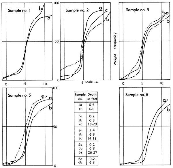
Figure 7--Size-distribution curves for flood-plain deposits.
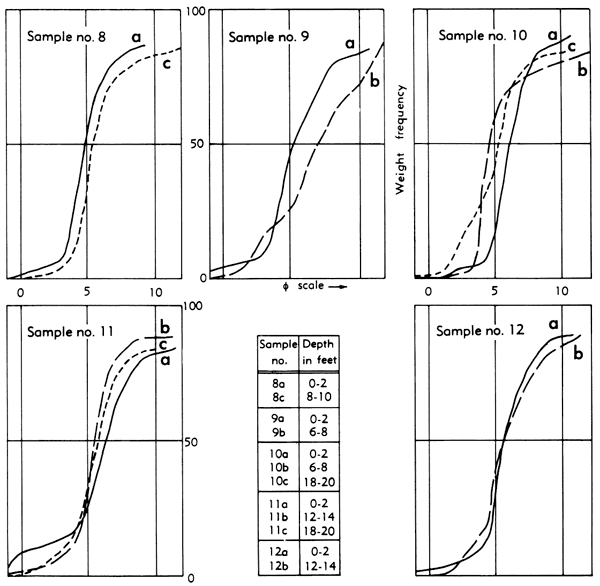
Table 4--Sedimentary parameters of alluvial terrace deposits.
| Sample no. |
Depth, feet |
φ-median | Sorting index |
Percent gravel |
Percent sand |
Percent silt and clay |
|---|---|---|---|---|---|---|
| 1a | 0-4 | 5.3φ | 4φ | 13.79 | 86.21 | |
| 1b | 6-8 | 5.3φ | 2.3φ | 15.36 | 84.64 | |
| 2a | 0-2 | 4.4φ | 1.7φ | 19.70 | 80.30 | |
| 2b | 6-8 | 6.25φ | 3.5φ | 12.39 | 87.61 | |
| 2c | 18-20 | 5.3φ | 5φ | 10.84 | 22.06 | 67.10 |
| 3a | 2-4 | 5.25φ | 3.3φ | 13.79 | 86.28 | |
| 3b | 6-8 | 6.1φ | 4φ | 7.725 | 92.27 | |
| 3c | 14-18 | 5.3φ | 3.9φ | 24.05 | 75.95 | |
| 5a | 0-2 | 5.25φ | 3.1φ | 11.89 | 88.11 | |
| 5b | 6-8 | 6.2φ | 4.2φ | 10.13 | 89.87 | |
| 5e | 26-27 | 5.1φ | 2.8φ | 30.77 | 69.23 | |
| 6a | 0-2 | 7φ | 3.3φ | 6.151 | 93.48 | |
| 6b | 6-8 | 8. 1φ | 3.8φ | 3.10 | 96.90 |
Table 5--Sedimentary parameters of flood-plain deposits.
| Sample no. |
Depth, feet |
φ-median | Sorting index |
Percent gravel |
Percent sand |
Percent silt and clay |
|---|---|---|---|---|---|---|
| 8a | 0-2 | 5φ | 2.22φ | 6.80 | 93.20 | |
| 8c | 12-14 | 5.3φ | 3.4φ | 10.27 | 89.73 | |
| 9a | 0-2 | 5.3φ | 3.4φ | 8.33 | 91.67 | |
| 9b | 6-8 | 7φ | 3φ | 20.68 | 79.32 | |
| 10a | 0-2 | 6.1φ | 1.8φ | 6.0 | 94 | |
| 10b | 6-8 | 4.3φ | 4.2φ | 3.40 | 96.60 | |
| 10c | 18-20 | 5.3φ | 3.9φ | 10.27 | 89.73 | |
| 11a | 0-2 | 6.2φ | 3.6φ | 15.35 | 84.65 | |
| 11b | 12-14 | 5.3φ | 1.8φ | 11.68 | 88.32 | |
| 11c | 18-20 | 5.4φ | 3φ | 3.39 | 12.81 | 83.80 |
| 12a | 0-2 | 5.3φ | 2φ | 2.63 | 11.77 | 85.60 |
| 12b | 12-14 | 5.2φ | 2.8φ | 18.87 | 81.13 |
Graphic standard deviation (φ84-φ16) / 2 is used as a measure of the degree of sorting (Inman, 1952). Folk and Ward (1957) have proposed a more satisfactory sorting measure using 95th and 5th percentiles, in addition to 84th and 16th percentiles. The sediments described in this report, however, are generally fine grained, and it is impractical to measure the 95th percentile. Friedman (1962) has suggested use of Inman's sorting index for such sediments.
Grain-size analysis shows that silt and clay constitute 86 percent and 84 percent of the flood-plain and alluvial terrace deposits respectively.
The degree of sorting of the sediments is determined on the basis of the following sorting scale proposed by Folk and Ward (1957):
under 0.35φ, very well-sorted;
0.35 - 0.50φ, well-sorted;
0.50 - 1.00φ, moderately sorted;
1.00 - 2.00φ, poorly sorted;
2.00 - 4.00φ, very poorly sorted; and
>4.00φ, extremely poorly sorted.
Both types of deposits are poorly to very poorly sorted and show no systematic variation of phi-median and sorting either with depth or with the distance of transportation. The terrace deposits show a greater variation in sorting than the flood-plain deposits. Comparison of the sedimentary parameters of alluvial terrace and flood-plain deposits is shown in Table 6.
Table 6--Comparison of sedimentary parameters of flood-plain and alluvial terrace deposits.
| Type of deposit |
Average φ-median |
Average φ-sorting |
Degree of sorting |
Percent silt and clay |
|---|---|---|---|---|
| Flood-plain (Wisconsinan) | 5.6φ | 3φ | Poorly to very poorly sorted | 86.6 |
| Terrace (Illinoisan) | 5.8φ | 3.45φ | Poorly to extremely poorly sorted | 84.4 |
Similarity of the grain-size parameters of the alluvial terrace and flood-plain deposits is probably due to the similarity in sedimentary processes which formed them.
The terrace deposits, considered Illinoisan in age, are relict flood plains topographically higher and locally adjacent to the younger flood-plain deposits of Wisconsinan age. Similarity of drainage basin location and depositional history should preclude the possibility of any significant differences in grain-size parameters, assuming that the source area was not significantly altered from Illinoisan to Wisconsinan time.
During the Illinoisan Stage, continental glaciers were remote from Kansas. In contrast, Wisconsinan continental glaciers, failing to reach Kansas by several hundreds of miles, repeatedly invaded the Missouri Valley to the north of Kansas (Frye and Leonard, 1952). Although glacial outwash did not reach the Neosho River valley, climatic effects were pronounced in the area.
Climatic changes associated with the Illinoisan and Wisconsinan glaciations indirectly resulted in a period of down-cutting, which increased the ratio of sediment load to water volume, followed by aggradation of streams. This situation probably caused a poorer sorting of the sediments.
Minor differences in the degree of sorting of terrace and flood-plain sediments are difficult to explain. Variation in the degree of sorting between terrace and flood-plain deposits is probably due to the extent each type of deposit was reworked.
It is not possible to draw any definite conclusions about the nature of deposition from sorting index alone because this may be a function of independent variables. Doeglas (1946) and Van Andel and Postma (1954) have observed that in rivers and currents acting as rivers, loads of coarse and fine sediments are largely independent of each other. This important property of sediment transport indicates that a parameter that measures the total attribute of a sediment, such as the sorting index, may obscure the character of deposition.
The variation in the degree of sorting of terrace and flood-plain deposits is not significant; therefore, it could not be used as a criterion for differentiation.
Heavy mineral suites of five flood-plain and five terrace samples were separated from the silt fraction using bromoform. The separated heavy mineral fractions were mounted on glass slides for identification. Minerals were identified by comparison with known standard heavy minerals mounted on glass slides, using binocular and petrographic microscopes.
Heavy mineral suites of terrace and flood-plain deposits are listed in Table 7. Comparison of the heavy mineral assemblages of the terrace and flood-plain deposits did not reveal any marked differences. Almost all heavy minerals found in the flood-plain deposits were also identified in the alluvial terrace deposits, with the exception of a few minerals such as epidote and kyanite, which are rare or absent from older alluvial terrace deposits.
A detailed quantitative determination of heavy minerals might help evaluate the differences, if any, in the heavy mineral suites of the flood-plain and terrace deposits.
Table 7--Comparison of heavy-mineral distribution on alluvial terrace and flood-plain deposits.
| Sample location* and depth | Zircon | Tourmaline | Staurolite | Garnet | Topaz | Magnetite | Epidote | Kyanite | |
|---|---|---|---|---|---|---|---|---|---|
| Terrace deposits | |||||||||
| 32-22-32cd | |||||||||
| 0-6 ft | x | x | x | x | x | x | Rare | ||
| 8-12 ft | x | x | x | x | x | ||||
| 12-16 ft | x | x | x | x | x | ||||
| 35-22-3cd | |||||||||
| 8-12 ft | x | x | x | x | x | x | |||
| 20-25 ft | x | x | x | x | x | ||||
| Flood-plain deposits | |||||||||
| 31-21-16aa | |||||||||
| 2-6 ft | x | x | x | x | x | x | x | x | |
| 12-16 ft | x | x | x | x | x | x | |||
| 35-21-1cc | |||||||||
| 0-2 ft | x | x | x | x | x | x | |||
| 12-16 ft | x | x | x | x | x | x | |||
| 18-20 ft | x | x | x | x | x | x | x | ||
| 32-22-32cd is sample no. 1a, 35-22-3cd is sample no. 5a, 31-21-16aa is sample no. 12a, and 35-21-1cc is sample no. 8a (Table 1). |
|||||||||
Clay mineralogy, grain-size analyses, and heavy mineral analyses of the alluvial terrace and flood-plain deposits of the Neosho River valley yielded the following results:
Given below are the typical sample logs of terrace and flood-plain deposits along the Neosho River valley.
| Sample No. 7--Sample log of test hole in NE NE sec. 24, T 33 S, R 21 E, on southwest corner of intersection, 20 feet west of north-south road. Augered June 6, 1963. Depth to water, 15.2 feet; altitude of land surface, 823 feet. | Thickness, feet |
Depth, feet |
|||
|---|---|---|---|---|---|
| Quaternary System | |||||
| Pleistocene Series | |||||
| Illinoisan terrace deposits | |||||
| Silt, brownish-gray, clayey | 3 | 3 | |||
| Silt, yellowish-brown, orange and gray clay stringers | 5 | 8 | |||
| Silt, yellowish-brown, clayey | 5 | 13 | |||
| Clay, yellowish-brown | 5 | 18 | |||
| Clay, yellowish-brown, medium-sized chert pebbles | 5 | 23 | |||
| Clay, yellowish-brown, silty, medium-sized sand and medium-sized pebbles | 5 | 28 | |||
| Pennsylvanian System | |||||
| Desmoinesian Stage | |||||
| Cabaniss Formation | |||||
| Shale, black | 1 | 29 | |||
| Limestone | 29 | ||||
| Sample No. 13--Sample log of test hole in SE SW sec. 1, T 35 S, R 21 E; on west shoulder of road opposite abandoned barn. Augered June 18, 1963. Depth to water, 14.5 feet; altitude of land surface, 790 feet. | Thickness, feet |
Depth, feet |
|||
|---|---|---|---|---|---|
| Quaternary System | |||||
| Pleistocene Series | |||||
| Wisconsinan and Recent alluvium | |||||
| Silt, reddish-brown, clayey | 14 | 14 | |||
| Silt, light-brown, sandy chert pebbles | 5 | 19 | |||
| Pebbles, dark-brown silt | 2 | 21 | |||
| Pennsylvanian System | |||||
| Desmoinesian Stage | |||||
| Cabaniss Formation | |||||
| Shale | 21 | ||||
Doeglas, D. J., 1946, Interpretation of the results of mechanical analysis: Jour. Sed. Petrol., v. 16, p. 19-40.
Folk, R. L., and Ward, Wily, 1957, Brazos River bar: A study in the significance of grain size parameters: Jour. Sed. Petrol., v. 27, p. 3-26.
Friedman, G. M., 1962, On sorting, sorting coefficients, and the log-normality of the grain size distribution of sandstones: Jour. Geology, v. 70, p. 737-753.
Frye, J. C., and Leonard, A. B., 1952, Pleistocene geology of Kansas: Kansas Geol. Survey Bull. 99, 223 p. [available online]
Frye, J. C., Glass, H. D., and Willman, H. B., 1962, Stratigraphy and mineralogy of the Wisconsinan loesses of Illinois: Illinois Geol. Survey, Cir. 334, 55 p.
Harrison, J. L., and Murray, H. H., 1957, Clay mineral stability and formation during weathering: in, Clays and Clay Minerals: Proc. Sixth Natl. Conf. on Clays and Clay Minerals, Natl. Acad. Sci.-Natl. Research Council, Washington, D.C., p. 144-153.
Inman, D. L., 1952, Measures for describing the size distribution of sediments: Jour. Sed. Petrol., v. 22, p. 125-145.
Jackson, M. L., 1957, Frequency distribution of clay minerals in major soil groups as related to the factors of soil formation; in, Clays and Clay Minerals: Proc. Sixth Natl. Conf. on Clays and Clay Minerals, Natl. Acad. Sci.-Natl. Research Council, Washington, D.C., p. 133-143.
Van Andel, Tj., and Postma, Hendrick, 1954, Recent sediments of the Gulf of Paria: Kon. Akad. Wet. Amsterdam, Afd. Naturkunde, Verh., Eerste Recks, v. 20, no. 5, 245 p.
Kansas Geological Survey, Geology
Placed on web Aug. 12, 2008; originally published in Dec. 1967.
Comments to webadmin@kgs.ku.edu
The URL for this page is http://www.kgs.ku.edu/Publications/Bulletins/187_5/index.html