Kansas Geological Survey, Bulletin 175, Part 2, originally published in 1965
Originally published in 1965 as Kansas Geological Survey Bulletin 175, Part 2. This is, in general, the original text as published. The information has not been updated.
Evidence of superficial deformation of both lithified and nonlithified sediments ascribed to ice push is found in northeastern Kansas. Folds, fractures, and faults at right angles to the direction of ice movement are features common in this area and are dependent on the competency of the units involved in the deformation, which in some cases was controlled by freezing rather than lithologic composition.
These structures indicate two distinct advances of ice, one from the northeast and one from the northwest. The advance to the southeast is of Kansan age. This would imply a Nebraskan age for the southwesterly advance and consequently for the Kansas Till reference section located southwest of Atchison.
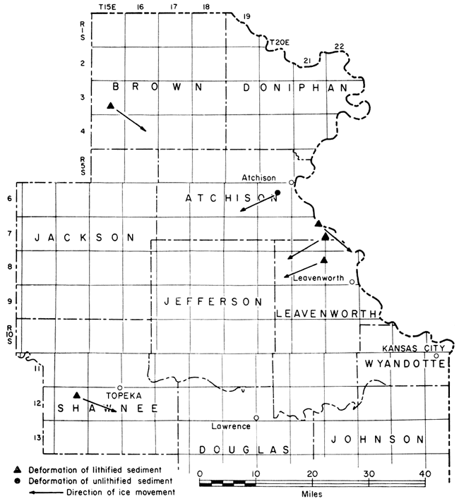
Superficial deformation of pre-Pleistocene bedrock, as well as of glacial debris, is a commonly reported phenomenon in areas of Pleistocene glaciation. Structures in Kansas resulting from ice push were first described by Frye and Leonard (1952, p. 73). Shortly after the publication of an article by Wood (1959) concerning deformation in Shawnee County, an effort was initiated by the authors to locate and describe other areas in northeastern Kansas that had undergone deformation. During the fall of 1962 and the spring of 1963, outcrop areas in Brown, Doniphan, Jackson, Atchison, Shawnee, Jefferson, and Leavenworth counties were systematically examined for evidence of deformation attributable to Pleistocene glaciation. Structures were studied to determine the direction of ice movement, the condition of the rocks and sediments during deformation, and the mechanics of deformation at the time of the glacial advance (Fig. 1).
Figure 1--Sites of deformation by ice push in northeastern Kansas.
The northeastern counties of Kansas are in an area of gently rolling farm land designated as the "Dissected Till Plains" (Fenneman, 1938, p. 588), a region generally delimited as the area underlain by Kansas Till.
Northeastern Kansas has generally reached a submature to mature stage of erosion (Fenneman, 1938), and good exposures of bedrock are difficult to locate, since the surface consists either of a well-developed soil profile or extensive Kansas Till. Gravel pits, limestone quarries, road cuts, and stream channels provide the best locations for finding evidence of deformation by ice push.
Previous studies concerned with deformation of strata by an overriding glacial ice sheet have dealt mainly with structures in non-lithified or poorly lithified sediments. One of the best exposures of rocks deformed by ice push was found at Moens Klint, Denmark, where non-lithified Cretaceous and Tertiary sediments are complexly folded and faulted (Lyell, 1873, p. 388-395).
In 1894, Geikie (1894, p. 338-340) described distortion and folding in glacial drift along the coast of Norfolk, England, and it was he who first attributed the deformation to glacial ice movement.
The first mention of deformation of sedimentary rocks by glacial action in North America was in an article by Sardeson in 1906. He described a section near Minneapolis, Minnesota, where he regarded folding and thrusting of a limestone to have been accomplished by the force applied by the overriding Wisconsinan ice sheet. Structures in Kansas resulting from deformation by ice push have been discussed by Frye and Leonard (1952, p. 73) and Wood (1959).
Only the first two glacial advances of the Pleistocene, the Nebraskan and the Kansan, reached as far south as northeastern Kansas. Differentiation of the till of these two stages is extremely difficult, and only through a detailed analysis of these tills and a study of stratigraphic relationships can a definitive age be ascertained.
The Nebraskan Stage includes all sediments deposited during the first glacial stage of the Pleistocene. Sediments of the Nebraskan stage, including the David City Formation, Nebraska Till, and Blanco Formation, are generally less well exposed than are sediments of the Kansan Stage.
Evidence of the Aftonian Interglacial Stage may be found in scattered locations in northeastern Kansas where it consists of decapitated soil profiles, which are predominantly gumbotil.
The lowest unit representing the Kansan Stage is the Atchison Formation. It consists of well-sorted silts, sands, and some gravel, and is considered to be outwash deposited in proglacial lakes. The Kansas Till is generally indistinguishable from the Nebraska Till.
The Kansan ice sheet reached farther south than did the Nebraskan. From the southernmost occurrence of Kansas Till, Frye and Leonard (1952) determined that the ice sheet "reached the south side of the Kaw Valley as far west as the mouth of the Vermillion River. This glacier extended westward across the valley of Little Blue River south of the Nebraska state line."
In Doniphan County, Dort (personal communication) has observed two tills, the older deeply grooved on its weathered surface and the younger deposited directly upon it. The grooves, developed during the advance of the younger ice sheet (Kansan) over the older weathered till (Nebraskan), indicate a direction of ice advance to the southeast.
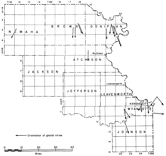
Schoewe (1941) documented the directions of ice advance with a list of glacial striae in northeastern Kansas (Fig. 2). Southward and southeastward directions of movement are indicated, but the relationship between direction and stage cannot be ascertained.
Because northeastern Kansas is near the southern limit of ice advance, the ice sheet must have been relatively thin in the areas where deformation occurred.
Figure 2--Orientation of glacial striae in northeastern Kansas (modified from Schoewe, 1941).
The criteria for recognizing deformation by ice push in a glaciated area are several: (1) local and superficial disturbance of beds showing abrupt termination at relatively shallow depths, (2) folding and faulting at right angles to the direction of ice flow, which in areas of tectonic folding may be completely incompatible with the regional structural pattern, (3) differential movement of competent beds over less competent ones, with competency in many cases determined by the presence or absence of ground ice rather than lithology, and (4) intimate admixing of glacial till with the disrupted and disturbed beds.
Deformation of strata may occur in several ways: (1) Non-lithified or poorly lithified sediments incorporated into the glacial ice may undergo deformation in the same manner as does glacial ice itself (Slater, 1929, p. 488). Upon slow wasting of the glacier, the sediments retain these structures. This so-called "glacial pseudomorph" structure is associated with the glacial terminal zone where the ice has thinned considerably and is moving very slowly. (2) The force of frictional drag, developed as the glacier overrides the substrata beneath it, causes faulting and folding. Sardeson (1906) suggested that folding and faulting even of limestone might take place under such a stress. Mathews and MacKay (1960) demonstrated that the shear strength of most sediments exceeds the estimated shear stress applied by a glacier on its substratum and that in order for failure to occur an unusually high stress must be developed beneath the ice, the sediments must have an unusually low shear strength, or unusually high pore pressures must be developed. This deformation, in contrast to (1), is associated with an active, thick glacial ice sheet. (3) Deformation can be caused by the weight of the overlying ice pressing or squeezing basal till into holes or crevasses in the ice sheet (Hoppe, 1952). This method of deformation would require a near stagnant ice mass, a condition in which fissures and holes might remain open for a considerable length of time and into which highly plastic sub-ice material could be squeezed.
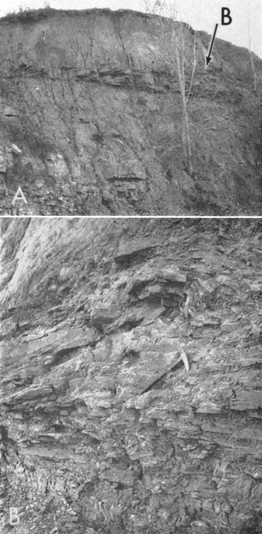
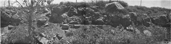
The area of deformation is located in the SE NE of sec. 28, T 3 S, R 15 E, 10 miles north of the town of Netawaka on US Highway 75. Here, on the west wall of an excavation for an underground Bell Telephone communication center, the normally horizontal sequence of limestone and shale was highly deformed. The hole was 38 feet deep and the north-south-oriented western face was 86 feet long. The communication center was under construction during 1962, and by the end of September the excavation was filled.
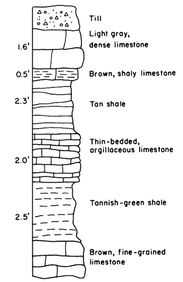
The Neva Limestone Member of the Grenola Formation (Lower Permian), a sequence of interbedded limestone and shale 11.9 feet thick, was exposed in the excavation (Fig. 3). About 27 feet of undifferentiated Pleistocene glacial till, including a thin soil profile, overlies the Permian rocks. The till includes particles ranging in size from clay to boulders 3 feet in diameter. The till is composed mainly of pink quartzite, schist, gneiss, and limestone.
Figure 3--Diagrammatic section of Neva Limestone Member (Grenola Formation) as exposed at Brown County locality.
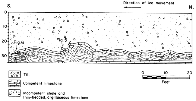
Deformation was confined to the southern four-fifths of the western wall of the excavation and was observed only in the upper limestone and shale. The uppermost limestone showed intense fracturing in the areas of folding; the underlying shale unit showed flowage from synclinal into anticlinal structures (Fig. 4). The lower 2-foot, thin-bedded, argillaceous limestone was disturbed only at the southern end of the wall where deformation was most intense.
Figure 4--Western wall of excavation in Brown County, Kansas, showing deformation of limestone and shale.
The superficial nature of the deformation is indicated by the non-deformation and normal horizontal position of the lowermost units of the Neva Limestone.
Glacial striae found on the surface of the uppermost limestone unit bear S 56° E, approximately at right angles to the strike of the axial planes of the "folds." These folds developed through fracture of the upper limestone and the rotation of these fractured blocks, and not through flowage.
Along the northern sector of the deformed area the upper limestone unit had been breached by shale piercement, with admixing of the shale and glacial drift. This intimate mixture of shale and glacial material attests to the glacial origin of these structures.
The structures are similar to those reported by Lamerson and Dellwig (1957) in Madison County, Iowa, although their magnitude is less than in the latter locality.
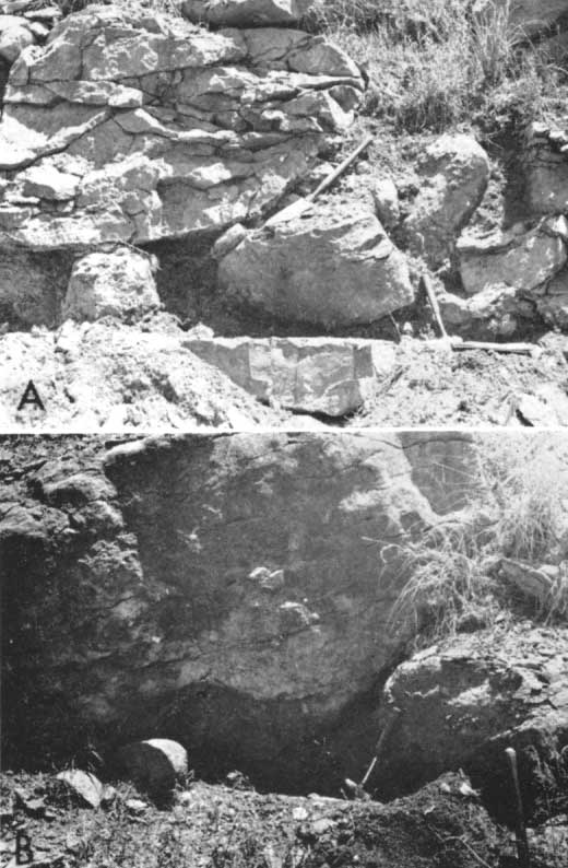
Deformation shown in the exposure increased in intensity from north to south (Fig. 5, A, B) To the north, the beds were formed into small folds with a maximum amplitude of 0.25 foot and a wave length of approximately 16 feet. Here, the shale was sufficiently plastic at the time of deformation to have flowed laterally and upward into the anticlines. The mean temperature, as indicated by fossil mollusks, was only slightly lower during this time than is found in Kansas today (Frye and Leonard, 1954, p. 161). With a mean temperature only slightly lower than the present one, the occurrence of permafrost, or permanently frozen subsoil, may be discounted, and, with the presence of considerable ground water, the flowage and shear of shale under the applied pressure seems probable. It must be remembered, however, that the soil was probably frozen at least part of the year to a depth of several feet.
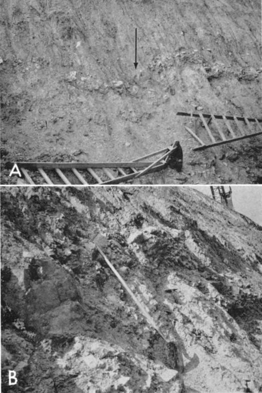
Figure 5--Excavation in Brown County, Kansas. A, Folding at southern end of excavation; large quartzite boulder (arrow) on lee side of anticline. B, Closeup view of fold shown In A (see Fig. 4 for location). Large quartzite boulder to left of shovel handle lies in lee of major anticline.
Mathews and MacKay (1960, p. 29) have suggested that high pore pressure may facilitate shearing in water-soaked sediments:
Pore pressure is developed in soils which were saturated prior to the glacial advance. With added load of glacier ice, compaction could only take place by exclusion of water in the pore spaces. This developing pore pressure may considerably cut down on shear stress needed to cause shear failure.
This hypothesis may well explain the ease of flowage which this shale exhibits. High pore pressure developed between the platy shale particles might conceivably have reduced the frictional bond between them, allowing the particles to slide over one another under less force than would have been necessary otherwise.
At the northern end of the western wall, where the folding was least severe, the brittle, uppermost limestone has broken into numerous blocks which have rotated to outline the folds. The shale has flowed toward anticlinal axes and, in one case, through a rupture in the overlying limestone, has mixed with the till above. The axis of the anticline, where the shale piercement occurs, has a bearing of S 55° W.
At the southern end of the western wall, the amplitude of folds in the limestone reaches a maximum of 2.6 feet and a wave length of 26 feet. Here, the brittle limestone shows maximum fracture and rotation of blocks. The axis of the largest fold has a bearing of S 60° W.
South of this large anticline is a large, rounded boulder of pink quartzite, which resembles the Sioux Quartzite of South Dakota. This boulder, measuring 3 feet in maximum dimension, was deposited in the lee of the developing anticline as a part of the lodgement till at the base of the glacier. In the shale to the south, in contrast to that to the north, the bedding planes generally follow the fold structure rather than piercing the overlying limestone. Where the most intense deformation occurs, the underlying 2-foot thick, thin-bedded limestone is highly fractured and cannot be traced as a single unit.
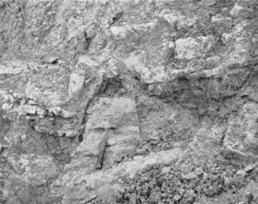
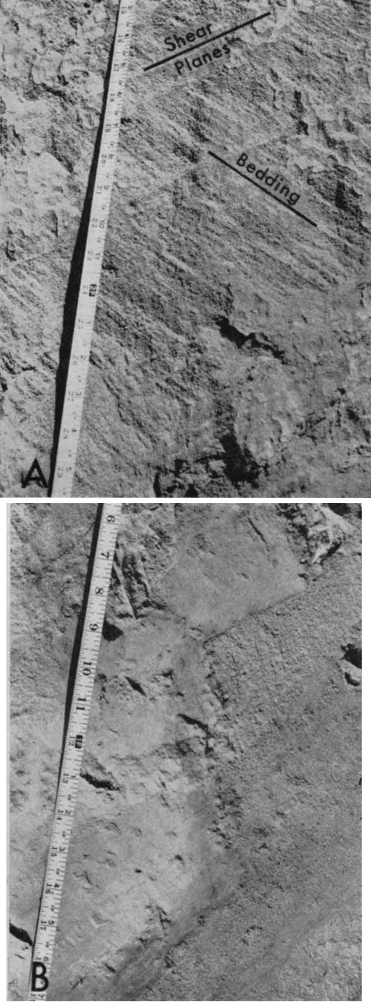
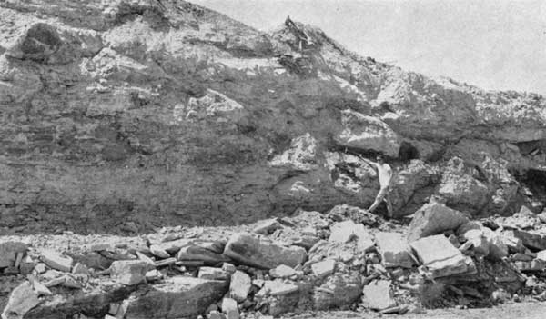
The intense folding abruptly terminates near the southern end of the western wall, and it seems probable that the normal sequence would be found a short distance south of the excavation. At the southern end of the western wall of the excavation was an undisturbed block of shale (Fig. 6). It is bounded by two outward-dipping faults; the southern fault plane dips 65° S, and the northern fault plane dips 60° N. To the north, a third, related fault dips approximately 24° N. The southernmost fault, along which the greatest movement has taken place, shows 0.02 foot of unbedded gray clay gouge along the fault zone, which is in marked contrast to the greenish, well-bedded, unaltered shale. Adjustment on the south side of the stable block was by normal faulting (Fig. 6). Stratigraphic separation of the base of the upper limestone is 0.5 foot. Drag has developed on the downthrown side and one large limestone block south of the gravity fault is rotated so as to almost parallel the fault surface. Only moderate deformation occurs southward toward the end of the excavation. Thrust faults developed along two planes on the northern side of the shale block. The bedding of the shale immediately adjacent to the north of the undisturbed block is also highly deformed and interlaced with well-developed shear surfaces.
Figure 6--Block of undisturbed shale at south end of exposure, showing relationship of block to faults (see Fig. 4). (Geologic hammer lies in center of shale block.) Glacial debris lies at top of photo, above the Neva Limestone.
Since the lithology of the shale in the block is physically identical to the shale surrounding it, the only reasonable conclusion that may be reached is that the glacier advanced over this area at a time when pockets of frozen subsoil remained. Where the shale was thawed, it flowed easily, as there was an abundance of water available, but, where frozen, it resisted the applied force.
The warped, fractured, and distorted shale and limestone were pushed against this frozen block of shale, a low-angle thrust developing in the thawed shale, and a high-angle thrust fault developing at the plane of contact between the frozen block and thawed shale.
Although most of the overlying glacial sands and gravels were deposited when melting of the glacial ice took place, older lodgement till is intermixed with shale in the areas of limestone piercement. The direction of ice movement, as determined from structure orientation, was approximately S 30° E, with deformation occurring where there were still pockets of frozen ground present.
Location and Exposure
The exposure is located in the SE of sec. 10, T 6 S, R 20 E, along the north bank of a small east-flowing stream southeast of US Highway 59 and directly across the highway from a large bank of grain elevators.
The stream has cut a 40-foot bank into nonlithified glacial sediments which are exposed along the stream for approximately 300 feet (Fig. 7). The units present here include a lowermost blue-gray till [Nebraskan(?), Schoewe, 1938], the next younger, well-sorted, water-laid sands of the Atchison Formation, and the overlying Kansas Till into which have been intermixed "streamers and blocks of well-sorted tan sand and silt, judged to have been derived from the plowing of the underlying Atchison Formation by the overriding Kansan glacier" (Frye and Leonard, 1952, p. 75). This description best applies to the southern end of the present exposure. The Atchison sand is well sorted and thin bedded; the tills are predominantly clay and locally include a wide range of fragments, some as much as 0.16 foot in diameter. The tills are easily identified by the dark color resulting from water saturation of clays. The blue-gray Nebraskan(?) till shows an alteration to a brown color in a zone a few inches wide adjacent to the sand, so that the sand-till contact is not located at the point of color change.
The older blue-gray till has flowed up into the overlying Atchison sands, with some intermixing of sands and till along the contact zones. Shearing is a not uncommon phenomenon, and it is generally found more extensively developed in the sand units.
Structure and Mechanics of Deformation
Superficial deformation of Pleistocene sediments, in part ice-deposited, with extensive shearing in sand units and intricate post-depositional infolding of the Atchison Formation with Kansan and Nebraskan (?) tills gives indisputable evidence that the deformating force was glacial action.
The structures which best show the mechanics of deformation are at the northeast end of the exposure where a mass of till, which flowed upward to form an anticline, was at the same time thrust to the southwest (Fig. 7, A). The general appearance is of an overturned fold with a diapiric core on the south side of which a series of thrusts were formed in the later stages of deformation. In addition to a major fault at the base of the fold, a series of parallel faults with small displacements were developed at intervals of one or more inches in the steeply dipping sandstone (Fig. 8, A). Some drag has occurred adjacent to the faults, although displacement is not great. Faults extend only a short distance into the till, in which plastic flow has been prominent in the relief of stress. Displacements of several inches can be observed at the contact (Fig. 8, B), where faulting has to some degree controlled the emplacement of the till. The major fault strikes N 25° W and dips 40° E, and the series of parallel shear surfaces in the sand strike N 10° W and dip 45° NE. Sand beds on the southwest side of the anticline have been rotated from a nearly horizontal to a nearly vertical position by folding. Similarly, on the northeast side of the fold, the sand beds increase in dip to the south as the upfolded till is approached.
Figure 7--Flowage of till up into sand beds of the Atchison Formation at northern end of exposure. The structure is truncated by a thin, dark band of overlying till. Sand beds on the right (south) side are upturned against the diapiric till which has moved, in part, upward and southward along thrust planes: A, Outcrop in 1951 (from Frye and Leonard, 1952, p. 75); B, Outcrop in 1963.
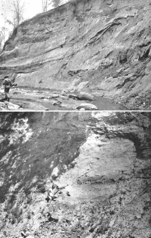
Figure 8--Exposure near Atchison, Kansas. A, Deformation of bedding and shearing in Atchison Formation on south side of the major fold. Beds in area immediately adiacent are horizontal. B, Thrusting along the glacial till-sand contact on the south side of the anticline at the north end of the exposure. Till (at left) is light, and sand (at right) is dark.
The proglacial sands of the Atchison Formation were deposited upon the Nebraska(?) Till. With the readvance of the ice, the sands, and probably the underlying till, were frozen. In spite of Mathews' and MacKay's assertion (1960) that frictional drag is unable to develop sufficient force for deformation, it seems the most reasonable explanation for the development of the major structure, for there is no indication of the movement of the deformed sediments over the undisturbed sediments below. The symmetry of the fold at the northeast end of the exposure, shearing in the sands and the till, and lack of development of a décollement above the normally excellent potential surface of sliding suggests a frozen state during deformation. The top of the major structure is unconformably overlain by a till layer, which suggests planation during development of the structure. Fold axes and thrusts indicate ice advance from an east to a northeasterly direction.
Location and Exposure
This area of deformation is in the SE SE SE sec. 13, T 7 S, R 21 E, 7 miles east of Potter, Kansas, along the extension of State Highway 74 and 0.5 mile north along the secondary road which terminates the easterly extension of Route 74. The exposure is in an abandoned quarry on the east side of the road.
Rocks exposed along the southern side of the quarry include the upper three members of the Oread Formation and the overlying Jackson Park Shale Member of the Kanwaka Shale (Fig. 9, A). Deformation is confined to an upper sandstone-shale unit of the Jackson Park Shale where it is exposed in the most westerly 21 feet of a north-facing quarry face. The unit consists of irregularly interbedded shale and buff, competent, argillaceous sandstone; the unit averages about 2.5 feet in thickness, with individual beds ranging in thickness from approximately 0.01 to 0.7 foot. The lower part of the Jackson Park Shale, 11.5 feet of green, well-bedded, micaceous shale, shows no deformation.
Figure 9--Quarry near Oak Mills, Atchison County, Kansas. A, South-facing wall in quarry. The sandstone-shale unit of the Jackson Park thickens in the anticline. Anticline is to right of tree in foreground. B, Detail of fold at east end of sandstone-shale unit in A. Imbrication of sandstone and folding of shales have resulted in development of the anticline.
Overlying this sequence of Pennsylvanian rocks is 10.5 feet of undifferentiated glacial material, at the base of which are found rounded quartz pebbles as much as 0.2 foot in diameter. No age determination of the glacial material was possible.
Structure and Mechanics of Deformation
The superficial nature of the disturbing force is indicated by the lack of deformation in the lower portion of the Jackson Park Shale Member, as well as in the exposed members of the underlying Oread Formation. It is evident that deformation of the sandstone-shale sequence occurred after lithification, for the thin-bedded units show considerable fracture, especially in the area of folding.
Deformation increases in intensity from east to west, with maximum distortion at the west end of the quarry face where an anticline has developed in the argillaceous sandstone and interbedded shales of the Jackson Park. The axis of the major fold has a bearing of S 21° E. The argillaceous sandstone and interbedded shales have thickened to 5 feet in this anticline. To the east, this same sequence of shale and shaly sandstone thins to 0.5 foot (Fig. 9, A).
Deformation of the upper portion of the Jackson Park Shale has occurred through movement of the competent, thin-bedded, argillaceous sandstone layers along the interbedded shale units, which have acted as a lubricant. As slippage occurred along planes of weakness in the shale the individual sandstone slabs were rotated approximately 10°, and pushed upward in an imbricate fashion one on top of another. The interbedded shales and sandstone absorbed the applied force, as the lower massive shale shows no sign of deformation.
The movement of the sandstone slabs over one another culminated in the formation of the anticline shown in Figure 9, B.
Occurrence of disturbed shale west of the anticline and leeward of ice advance suggests that the glacial ice did not remove the soft shales overlying the sandstone-shale unit until after deformation had occurred. Only in the lee of the anticline was the shale protected from the direct scouring action of the glacier. The forward-moving ice sheet did, however, completely disrupt and nearly obliterate the bedding. The upper shale apparently was frozen when pressure was applied, for deformation has occurred through fracture instead of by flowage. The limitation of deformation to such a thin surficial layer of relatively competent sandstone which is underlain by less competent and normally more easily deformed material, and the occurrence of a small remnant of highly deformed shale above the sandstone suggest that perhaps at the time of deformation a thick unit of the Jackson Park was present above the deformed sand-shale sequence. Deformation occurred in the frozen upper shale which moved as a part of the ice mass. The sandstone-shale unit may have contained water under high pore pressure marking the lower limit of permafrost and the surface along which shear strength was at a minimum. The direction of ice movement was approximately S 60° W.
Location and Exposure
The area of deformation is located in a new quarry in the NE SE of sec. 11, T 7 S, R 21 E. The quarry lies on the south side of the Oak Mills-Port Williams road, high on the bluffs overlooking the Missouri River. The sequence exposed is similar to that exposed in the Oak Mills locality, including the Jackson Park Shale Member of the Kanwaka Shale and the underlying Kereford, Heumader, and Plattsmouth members of the Oread Formation.
Exposure of deformation is confined to an east-west quarry face in which the Jackson Park Shale is cut by a low-angle fault with an apparent dip of 12° W. Blocks of Kereford Limestone averaging about 2.0 feet thick have been moved eastward along this fault (Fig. 10). Although the Kereford has been broken during thrusting, strike and dip of individual blocks are consistent and the continuity of the bed has been maintained. Horizontal glacial sands up to 6 feet in thickness lie above this upthrust mass.
Figure 10--Thrusting of Kereford Limestone over Jackson Park Shale. Person in photograph stands on Kereford and faces a Jackson Park sequence which is completely without deformation. Near Port Williams, Atchison County, Kansas. (Geologic hammer delineates surface of thrusting.)
Structures and Mechanics of Deformation
As in previously described areas, the deformation is of a superficial nature, in this instance not extending below the Jackson Park except in an area to the west from which the Kereford was derived. Deformation was post-lithificational and is closely associated with glacial deposits.
Only the single low-angle thrust, with associated features of deformation, is visible at this locality. An apparent dip of 12° W was recorded on a face striking N 80° W. An estimated strike of the fault surface is N 40° E, with a dip of 14° NW. The fault can be traced for about 80 feet along the quarry face. For the most part, it is marked by a 1-2-inch thick slickensided clay zone. At the east end of the exposure the clay zone is approximately 9 inches thick, but it shows little distortion except for slickensides. Kereford blocks on the upper plate are broken and in some instances are separated by sand, presumably the same as that above. Bedding in the sand above is horizontal and not parallel to the bedding of the Kereford on the upper plate. The overlying sand is without deformation.
There is no deformation in the Jackson Park or in any units below the clay zone. Progressive truncation downward in the Jackson Park is easily recognized eastward along the face.
The movement of the Kereford Limestone as a unit, essentially intact, and the lack of deformation in any of the underlying units strongly suggest that the ground was frozen, at least to the depth of the Plattsmouth, at the time of shearing. The Kereford, frozen to the base of the ice sheet, slid southeastward (?) along a shear surface which initially developed at the base of the Kereford in the underlying Heumader Shale, breaking upward in the direction of ice advance through the Kereford and the overlying Jackson Park. All stress was relieved in the thin clay zone immediately below the overthrust plate.
The area of deformation is located along the northeast face of a limestone quarry in the SE NW of sec. 11, T 8 S, R 21 E, approximately 8 miles northwest of Leavenworth on the west side of US Highway 73. Upper Pennsylvanian sediments are exposed in a small hill on the north side of the quarry on northeast-trending quarry faces in which are exposed the deformed Jackson Park Shale and the underlying undeformed Kereford Limestone Member of the Oread Formation.
The upper part of the Jackson Park Shale at this exposure is a limonite-stained, micaceous, medium-grained, thin-bedded, poorly cemented sandstone about 6 feet thick. The lower portion of the Jackson Park is a gray-green, micaceous, thin-bedded shale. On the northeast-trending face, the shale ranges in thickness from 0.7 foot at the northeast to 7.1 feet at the southwest end of the exposure. Below the Jackson Park Shale lie the Kereford, Heumader, and Plattsmouth members of the Oread Formation. An average of 5 feet of weathered glacial till lies above this Pennsylvanian sequence and includes well-rounded quartzite and gneissic pebbles and boulders.
Intense deformation is confined to the sandstone and shale of the Jackson Park. The lower part of the shale is deformed only at the eastern end of the exposure, and the Oread Formation shows no sign of deformation. The basic structure exposed on a face about 50 feet long is a low angle thrust fault along which a block of sandstone of the Jackson Park has been thrust to the southwest along the underlying, now distorted, basal shale of that unit (Fig. 11, A; Fig. 12). The sandstone bedding planes now have a dip of approximately 30° NE. The fault plane on which movement occurred is best exposed on the southeast-facing cut, the dip of the fault ranging from 33° at its upper extremity downward to zero degrees where it parallels the bedding. The underlying shale has been warped and dragged upward against the overthrust block as pressure was applied and thrusting occurred (Fig. 11, B). Some shale has been squeezed or dragged upward along the fault surface.
Figure 11--Quarry northeast of Leavenworth, Kansas. A, Quarry face showing the upper members of the Oread Limestone and the thrusted sandstone block of the Jackson Park Shale Member of the Kanwaka Shale. B, Exposed fault plane in the sandstone unit of the Jackson Park Shale. Fault dips to right with sandstone on its upper plate. Drag has occurred in the underlying shale.
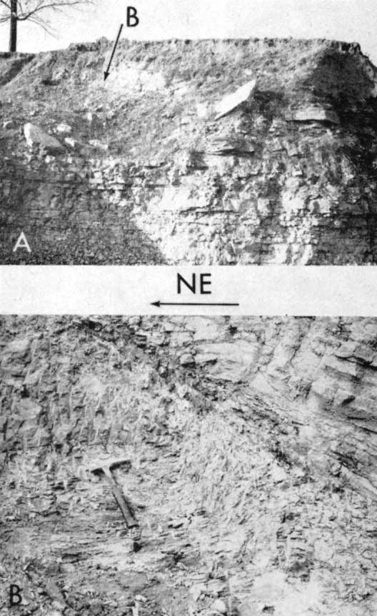
Figure 12--Schematic diagram of northeast-trending quarry face showing thrusting and shale deformation (quarry north of Leavenworth).
Movement is also evidenced by minor folding in the shale, both near the sandstone-shale contact and in advance of the southwest end of the fault. The axes of these folds, which have a bearing of approximately N 22° W, are parallel to the strike of the fault.
The fault surface is well exposed on a northwest quarry face, although the structures in the underlying shale cannot be seen. The overthrust sandstone block is well exposed and cut by several small faults of various dips and only minor displacement.
Thrusting has been responsible for removal of the lower shale unit of the Jackson Park at the northeast end of the exposure. Orientation of folds relative to the thrust and to one another indicates deformation by a directional force. The intense plastic deformation of the shale suggests deformation in an unfrozen condition. During forward motion of the upper sandstone plate the shale below was removed by squeezing. An alternate explanation, thrusting of the block along an erosional surface, is not likely because of absence of glacial debris along the fault surf ace.
The ice advance upon the Leavenworth County area was from N 68° E. This direction of ice movement is in almost perfect accordance with that of ice movement ascertained for the Atchison County area approximately 4 miles north.
An almost unique type of deformation, first described by Wood (1959), is found in the NW SE of sec. 10, T 12 S, R 14 E, 200 yards south of Kansas Highway 4, along a north-south dirt road.
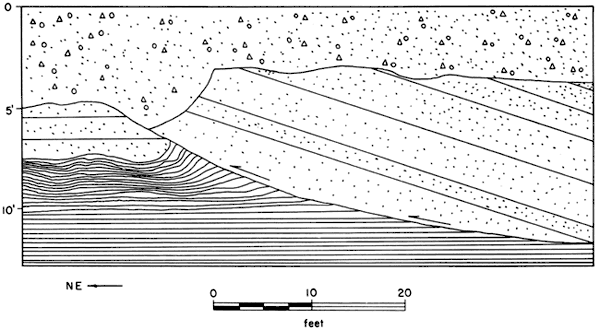
In descending order, rocks exposed include the Tarkio Limestone Member of the Zeandale Formation, the Willard Shale, and the Elmont Limestone Member of the Emporia Formation. The Tarkio Limestone is a yellow-brown, rather massive, thick unit with a maximum thickness of 4 feet. The Willard Shale, normally 40 feet thick at this locality, is found only as boulders or thin, distorted remnants (Fig. 13). The Elmont Limestone lies below and has not been disturbed.
Figure 13--Road cut (Shawnee County, Kansas) showing Tarkio Limestone separated from Elmont Limestone by glacial debris and isolated thin (less than 1 foot) remnants of Willard Shale. A larger version of this image is available.
Deformation at this locality does not involve recognizable folding; instead, it is evidenced by fracturing, thrusting and rotation of blocks of Tarkio Limestone and by the almost complete absence of the Willard Shale, a unit which attains its normal thickness of 40 feet within a half a mile of this area of deformation in all directions. Rotation of the Tarkio has been accomplished primarily through movement along a series of north-dipping faults which cut the limestone and terminate downward in a mixture of Willard Shale and glacial debris that overlies the Elmont (Fig. 14, A, B). The glacial material is relatively well indurated and in places cemented to the under surface of the Tarkio. Near the northern end of the cut, in a zone several feet wide, the Willard Shale has been squeezed upward, breaching the overlying Tarkio Limestone. In the center of this shale mass, a block of Tarkio Limestone has been rotated so that it lies in a nearly vertical position.
Figure 14--Thrust faults within the Tarkio Limestone. Glacial debris lies between the Tarkio and Elmont Limestones and along fault surfaces. A, Thrusting has been along a surface parallel to the shovel and also along a surface intersecting the hammer handle and parallel to the shovel. Large isolated blocks are Tarkio except in dark recessed area to lower left below shovel, which is shale. Interstitial material is mixed glacial debris and shale. B, Tarkio in upper plate shows tilting to left (north). Point of geologic hammer is on shale boulder which is completely enclosed in glacial debris. Hammer handle is on Tarkio, head on Elmont.
Numerous glacial erratics are found at the Tarkio-Elmont contact and along the faults. These are composed of quartzite, granite, gneiss and limestone and range in size from pebbles to small boulders. The Willard Shale occurs as distorted material in a thin layer between the Elmont and Tarkio Limestones, and as plastic masses squeezed along faults and into the breach in the Tarkio Limestone. It also occurs as blocks of shale up to 1 foot in diameter in which there is no disturbance of bedding, the shale appearing to have behaved as a resistant mass during the weathering process. Except for faulting and piercement by shale, the Tarkio Limestone has maintained its continuity. Deformation extends northeast of the road cut for about 500 feet, as indicated by tilted blocks of Tarkio, the strike of the bedding averaging N 45° E, with an average dip of 30° NW.
Glacial striae with a general southeasterly trend have been reported by Wood (1959, p. 306). Unweathered surfaces of the Elmont examined most recently show polishing and gouging with a similar trend of S 70° E.
Critical to the determination of origin of deformation in this area are: (1). glacial debris below the Tarkio and along the fault planes; (2) imbricate thrusting of Tarkio blocks onto one another; (3) lack of deformation in the strata below the Willard; and (4) presence of the Willard Shale both as boulders, apparently behaving as rigid material, and as a plastic lubricating layer along which the overlying Tarkio Limestone slid. The distribution of debris, intermixed in part with Willard Shale, along the entire surface of Elmont and along the thrust planes indicates that the Tarkio must have been transported to its present position as a unit. The overriding of the Elmont, to the extent that the two limestones are separated throughout the entire length of exposure by glacial debris, suggests the incorporation of the Tarkio into the ice sheet (frozen to it) and the movement of this portion of the glacier along the Willard Shale, which offered little frictional resistance. The ice first advanced over this area, stripping off the Tarkio and, in part, the Willard, and deposited lodgement till on the surface. The large "squeezeup" of Willard within the Tarkio indicates that some shale was present at the time of the positioning of the Tarkio. The advancing ice then carried a sheet of Tarkio from the northwest to its present position, squeezing out, at this time, the remaining plastic Willard Shale. The Tarkio was plastered on this surface as the forward movement met increased frictional resistance. The rearward portion continued forward movement on a series of imbricate thrusts. Willard fragments frozen within the ice sheet behaved as rigid masses. Lack of deformation in underlying shales suggests that the ground was frozen and that melt water had reduced the material at the ground-ice contact to a plastic state.
The direction of ice movement, determined by the bearing of striae on the Elmont and direction of strike and dip of the upturned Tarkio Limestone blocks, was from the northwest. Absence of deformation in underlying shales indicates that the ground was frozen.
The discussion of the localities affords only a glimpse of the effects of the movement of glacial ice over bedrock, as well as over its own previously deposited debris. Most of the localities described here are characterized by thrust faults, indicating that in most instances the ground was frozen at the time of deformation. Evidence of pockets of sediments not frozen at the time of deformation has also been found, and the existence of such pockets at the time of deformation indicates that such activity occurred along the margin of the ice sheet.
Two distinct directions of ice movement are indicated. Dort has established a southeasterly direction of movement of Kansan ice in Doniphan County. This conclusion is substantiated by the preservation of southeasterly trending striae and the near absence of that same feature trending southwest, for it would be assumed that the most recent ice advance (Kansan) would remove striae formed during earlier advances. If the conclusion that Kansan ice advanced to the southeast and Nebraskan to the southwest is correct, folds and thrust faults trending northwest-southeast must be related to Nebraskan ice advance. Thus, such structures in the till at the southwest Atchison site must be related to the Nebraskan ice advance. Consequently, this section of reference for Kansas Till must be Nebraskan in age.
Such structures as have been described may well give the best record of recurring ice advance, for unlike striations they are not destroyed with the advance of a new sheet. Certainly there is here recorded substantial evidence of the advance of Nebraskan ice a greater distance into northeastern Kansas than that which is generally accepted.
Fenneman, N. M., 1938, Physiography of the eastern United States: ed. 1, McGraw-Hill Book Co., Inc., New York, 714 p.
Frye, J. C., and Leonard, A. B., 1952, Pleistocene geology of Kansas: Kansas Geol. Survey, Bull. 99, p. 1-230. [available online]
Geikie, James, 1894, The great ice age: Deward Stanford, London, 545 p.
Hoppe, Gunner, 1952, Hummocky moraine region with special reference to the interior of Norboten: Geogr. Ann., Arg. 34, Heft 1-2, p. 1-72.
Lamerson, P. R., and Dellwig, L. F., 1957, Deformation by ice push of lithified sediments in south-central Iowa: Jour. Geology, v. 65, no. 5, p. 546-550.
Lyell, Charles, 1873, The geological evidences of the antiquity of man: John Murray, London, p. 1-572.
Mathews, W. H., and MacKay, J. R., 1960, Deformation of soils by glacier ice and the influence of pore pressures and permafrost: Royal Soc. Canada Trans., v. 54, ser. 3, sec. 4, p. 27-36.
Sardeson, F. W., 1906, The folding of subjacent strata by glacial action: Jour. Geology, v. 14, p. 226-232.
Schoewe, W. H., 1938, The west Atchison glacial section (abs.): Kansas Acad. Sci. Trans., v. 41, p. 227.
Schoewe, W. H., 1941, Glacial striae in Kansas: Localities 20, 21, 22, and 23: Kansas Acad. Sci. Trans., v. 44, p. 318-321.
Slater, G., 1929, Quaternary Period: in, Handbook of the geology of Great Britain: Thomas Murby, London, p. 457-498.
Wood, R.L., 1959, Ice-push deformation in Shawnee County: The Compass, v. 36, no. 4, p. 304-309.
Kansas Geological Survey, Geology
Placed on web Aug. 13, 2008; originally published in March 1965.
Comments to webadmin@kgs.ku.edu
The URL for this page is http://www.kgs.ku.edu/Publications/Bulletins/175_2/index.html