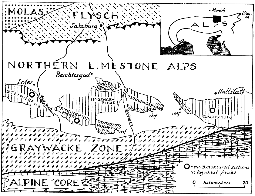
Figure 1--Index map showing five geological provinces: (1) Molasse Basin, of Oligocene-Miocene sediments, only partly involved in alpine folding; (2) Late Cretaceous-Eocene Flysch, folded and faulted; (3) Northern Limestone Alps, belt of Mesozoic sediments (mainly limestone), moderately to intensely folded and faulted; (4) Graywacke Zone, Paleozoic sediments and volcanics, intensely folded and mildly metamorphosed and (5) Alpine Core of Precambrian, Paleozoic (?) and Mesozoic rocks intensely deformed and metamorphosed. Northern Limestone Alps, together with Graywacke zone, form large thrust sheet (Oberostalpin) which has moved far from south, across Alpine core, onto Flysch. Rear boundary is not shown as thrust here, for in writer's view it represents later vertical fault with vertical and extensive lateral movement. Major units within Alpine core, and subsidiary thrust masses within Northern Limestone Alps, are not differentiated. Late Triassic rocks in major ranges in southern part of Northern Limestone Alps have been differentiated, lagoonal Lofer facies (Dachstein Limestone sensu stricto) being shown by vertical lines, barrier reef facies by cross shading. Three short sections described in paper are shown by circles. Base map from Yetters (1933) and others.
Kansas Geological Survey
Comments to webadmin@kgs.ku.edu
Web version August 2003. Original publication date Dec. 1964.
URL=http://www.kgs.ku.edu/Publications/Bulletins/169/Fischer/fig1.html