| Original published in W.W. Hambleton, ed., 1959, Symposium on Geophysics in Kansas: Kansas Geological Survey, Bulletin 137, pp. 309-320 | ||
Consulting Petroleum Geologist
The complete article is available as an Acrobat PDF file.
This paper presents a history of the events leading to development of the Windom pool, a geological and geophysical discovery in western McPherson County and eastern Rice County, Kansas. Windom was not highly regarded as a prospective producing area, because it was thought to be down dip from the Welch-Bornholdt pool, which is a stratigraphic trap. Widely spaced core holes in shallow Permian beds revealed only structural flattening, but preliminary subsurface mapping based on drillers logs from four widely spaced wells suggested an anticlinal structure. The structural feature was localized by a series of continuous seismic profiles, which shifted the top of the structure southward from its mapped location. A subsequent seismic program successfully obtained good reflections from Pennsylvanian rocks below the Lansing, from within the Mississippian, and from near the top of the Arbuckle, and tied with well control. The discovery well, which was located on top of the structure shown by the Lansing map, produced from basal Pennsylvanian chert conglomerate and from Mississippian rocks.
Since discovery, the pool has been mapped in detail by seismograph, and there has been close correlation of drilling and seismic programs. The success of the procedure is demonstrated by a record of 27 producing wells as compared to 4 dry holes. Production also has been found on the flanks of the structure, where the Pennsylvanian chert conglomerate is thicker than on top of the structure. Illustrations include seismic reflection and structural maps.
The Windom pool was discovered in November 1953 by Oil Trading Associates, Inc., and Trans-Era Petroleum, Inc. (now Sierra Petroleum Company, Inc.), at their No. 1 Asa Neel, located in the C NE SW NE sec. 30, T. 19 S., R. 5 W., McPherson County, Kansas, 3/4 mile south of Windom townsite and 3/4 mile east of the McPherson-Rice County line. The discovery well was drilled to a depth of 3,418 feet and completed after fracture treatment of Mississippian chert encountered at 3,409 feet. Additional commercial production from a basal Pennsylvanian chert conglomerate bed, 25 feet above the Mississippian, was indicated by drill-stem test. A pumping potential of 175 barrels of 32°-gravity oil, plus 25 percent water, was established by state test in February 1954. Since discovery, 40 wells have been drilled in the pool area; 33 are producing wells and 7 are dry holes. Of the successful wells, 12 produce from basal Pennsylvanian chert conglomerate beds and 21 produce from Mississippian rocks. Drill-stem tests on some of the Mississippian wells have proved that additional commercial production is available from the basal Pennsylvanian chert beds. Two of the wells completed as producers have since been abandoned.
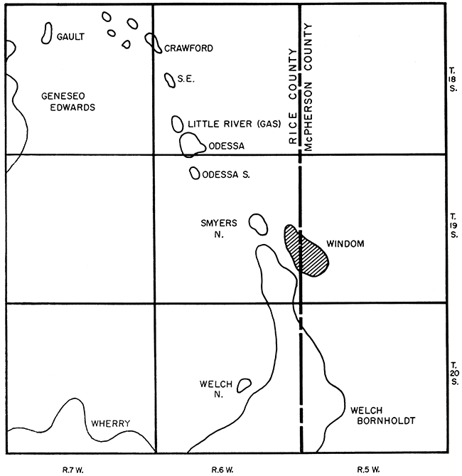
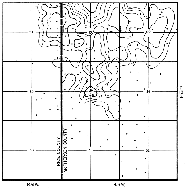
Pools near Windom are shown by Figure 1. All pools except Windom are either on or directly associated with an eastward-extending nose of the Central Kansas Uplift. Those shown on the northwestern portion of the map have their accumulation controlled principally by anticlinal folds and produce from porous beds of Pennsylvanian Lansing-Kansas City groups, from basal Pennsylvanian conglomerates, and from the Cambro-Ordovician Arbuckle group. On the southeastern portion of the map are shown the more extensive Wherry and Welch-Bornholdt pools, which are stratigraphic traps. Accumulation at Wherry was caused by the local up-dip pinchout of producing basal Pennsylvanian conglomerate beds. Accumulation at Welch-Bornholdt was controlled by the up-dip pinchout of porosity in the sharply dipping Mississippian chert beds fringing the eastern slope of the Central Kansas Uplift. The Windom pool is separated from the Welch-Bornholdt pool to the west by a syncline that represents the eastern extremity of the Central Kansas Uplift. Accumulation at Windom was the product of anticlinal folding.
Figure 1--Map showing location of Windom pool, McPherson and Rice Counties, Kansas.
The topography of the Windom area is flat or gently rolling. Roads are open along section lines, and U.S. Highway 56 runs in an east-west direction through the pool area. The surface rocks consist of lower Cretaceous shale.
The area in which the Windom pool is located had been in disfavor as a prospective producing area subsequent to the development of the Welch-Bornholdt pool. From the lack of contradictory evidence, the Windom area had been considered as down dip from the eastern producing limits of the Welch-Bornholdt pool, which is a stratigraphic trap. Surface outcrops were not available for inexpensive surface structural mapping, and a structural investigation of shallow Permian beds based on a core-drill program revealed only structural flattening over the area the pool occupies. The core holes were widely spaced, however, and it seems probable that more detailed coring would have revealed the structure now known to be present. Control for subsurface mapping consisted of only four widely spaced wells. The most critical of these wells was drilled in the early 1920's, and no samples were saved, hence it was necessary to rely on the drillers log for formation data. Fortunately, the driller's data on the beds used for the subsurface mapping proved reliable. Evidence of dip change in Mississippian beds, provided by the control wells, was related to structural trends in. the area, and a subsurface structure was mapped at a position that subsequently was verified. Evidence of a feeling of insecurity in the sparsely controlled subsurface structural interpretation is indicated by the fact that leases covering the structure were acquired by one of Kansas' most aggressive drilling concerns but were sold to the pool discoverers without drilling.
The lease purchasers first attempted to localize the general subsurface feature by running a series of continuous seismic profiles across the top of the indicated structure, beginning at the southwest corner of sec. 19, T. 19 S., R. 5 W., and extending 1/2 mile east and 3/4 mile north. The seismic records were not entirely dependable, but the data did indicate critical west and north structural dip. The seismic information shifted the top of the subsurface structure southward from its presumed position, and some delay in its further exploration was occasioned by the necessity for acquisition of additional leases to cover the indicated high area.
Central Exploration Company of Wichita, Kansas, was then engaged to enlarge on the first seismic survey and to tie the seismic data to well control. The seismic survey was so successful that after only 40 seismic profiles were made, at a cost of slightly less than $4,000.00, a drillable structure showing 40 to 100 feet of critical structural dip was determined to exist in sec. 19, 20, and 30, T. 19 S., R. 5 W.
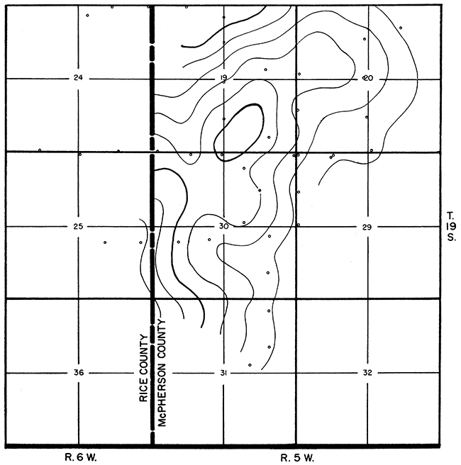
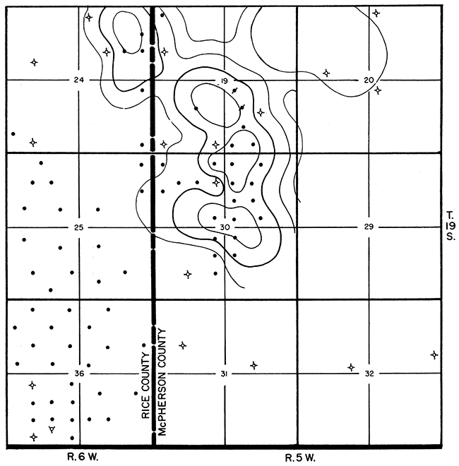
The most dependable seismic reflections came from a bed in Pennsylvanian rocks approximately 100 feet below the top of the Lansing; from within the Mississippian at approximately the top of Kinderhookian rocks; and from near the top of the Cambro-Ordovician Arbuckle. Seismic structural maps were constructed on each of these reflecting beds as shown in Figures 2, 3, and 4. Isotime maps also were constructed for the time interval between these reflecting beds. The highest part of the structure on the shallowest beds was determined to be in the SW NE sec. 30 (Fig. 2). On each succeeding deeper bed (Fig. 3 and 4), the structure became more pronounced and shifted northward so that at Arbuckle level the highest point had moved 1f2 mile north to the SW SE sec. 19. Experience with seismic work in western Kansas caused more confidence to be placed in the middle Pennsylvanian (Lansing) structural data, and location for the discovery well was chosen from the highest structural points on the Lansing.
Figure 2--First seismic map on Pennsylvanian (Lansing) reflection. Contour interval 20 feet.
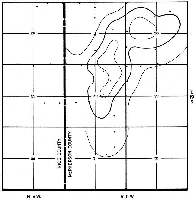
Figure 3--First seismic map on Mississippian reflection. Contour interval 20 feet.
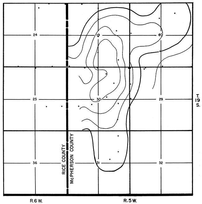
Figure 4--First seismic map on Cambro-Ordovician (Arbuckle) reflection. Contour interval 20 feet.
The discovery well had been planned as a test of Ordovician rocks, provided, however, that it would be completed in shallower formations if production from these rocks could be assured. Drill-stem tests of the basal Pennsylvanian conglomerate chert bed and of the Mississippian proved both to be productive, and the well was therefore stopped in the Mississippian.
Inasmuch as seismic data indicated that the Ordovician high was in the SW SE sec. 19, the second well, No. 1 Myers, was drilled into Cambro-Ordovician Arbuckle at a location in the C SW SW SE sec. 19. The subsurface structural maps (Fig. 5 and 6) show that No. 1 Myers was structurally higher than the discovery well on all formations penetrated by both. Basal Pennsylvanian chert beds were absent in the well, but Mississippian production was assured by two successful drill-stem tests. Minor to fair oil shows were encountered in deeper Viola and Simpson beds, but drill-stem tests did not encourage production tests. No other wells have been drilled on the structure to test pre-Mississippian prospects.
Figure 5--Subsurface structural map on top of Pennsylvanian Lansing Group. Contour interval 20 feet.
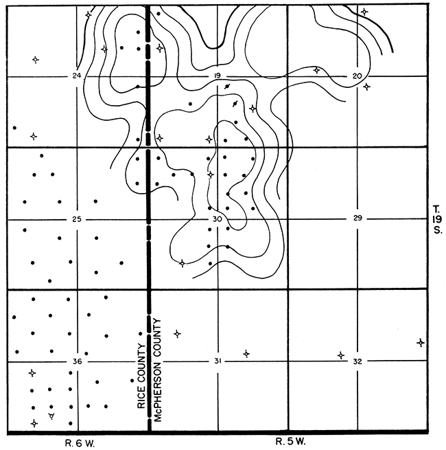
Figure 6--Subsurface structural map on top of Mississippian. Contour interval 20 feet.
Since its discovery, the pool area has been mapped in detail with the seismograph (Fig. 7, 8, and 9), and nearly all prospective drilling locations have been surveyed by that means. The seismic work has been done by stages, thus allowing incorporation of drilled subsurface data with seismic data as the program progressed. Success of that procedure is demonstrated by the fact that the discoverers of the pool have a record of 27 producing wells as compared with 4 dry holes. One of the dry holes was a failure only because of inadequate porosity development. A noteworthy partly developed northwestern extension of production into sec. 24, T. 19 S., R. 6 W., Rice County, is to be credited entirely to the seismic work.
Figure 7--Latest (1956) seismic map on Pennsylvanian (Lansing) reflection. Contour interval 20 feet.
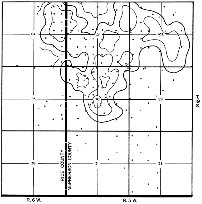
Figure 8--Latest (1956) seismic map on Mississippian reflection. Contour interval 20 feet.
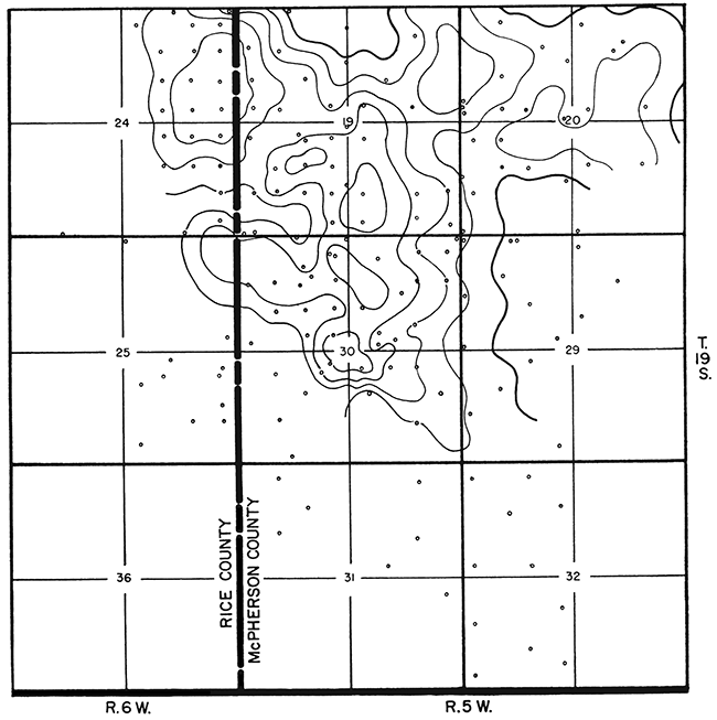
Figure 9--Latest (1956) seismic map on Cambro-Ordovician (Arbuckle) reflection. Contour interval 20 feet.
Early drilled wells were confined entirely to the highest portion of the structure, where most of the oil was produced from the Mississippian. The erratic thickness of Mississippian-derived conglomerate chert beds over the highest part of the structure suggested that these beds might be of more uniform thickness on the flanks of the structure. This proved to be true, as western and southern wells have produced from chert beds at places where the Mississippian is structurally too low to be productive. Mississippian rocks have been productive above datum depths ranging from minus 1,800 to minus 1,805 feet, but conglomerate beds are productive somewhat deeper. Structurally high wells in Mississippian conglomerate usually show only one chert bed, whereas most wells lower on structure show a second and stratigraphically higher chert bed. Both chert beds have been productive. Accumulating evidence indicates that the conglomerate may be productive completely across the syncline separating the Windom from the Welch-Bornholdt pool and may form a producing connection between the two pools.
The highest Mississippian wells have a productive oil column of 30 to 35 feet, and anticipated recoveries of nearly 100,000 barrels per well on a 10-acre spacing. Recoveries from the productive conglomerate wells have not been firmly established but seemingly are good. A 20-acre spacing has been established for the conglomerate wells because the conglomerate chert beds have a higher porosity than the Mississippian beds.
Appreciation is extended to Oil Trading Associates, Inc., to Oil Trading Corporation, Inc., and to Sierra Petroleum Company, Inc., for the privilege of presenting the seismic data on the Windom pool, and to Tom Stephenson for drafting the exhibits.
Kansas Geological Survey
Comments to webadmin@kgs.ku.edu
Web version Jan. 15, 2014. Original publication date 1959.
URL=http://www.kgs.ku.edu/Publications/Bulletins/137/Smith/index.html