| Original published in W.W. Hambleton, ed., 1959, Symposium on Geophysics in Kansas: Kansas Geological Survey, Bulletin 137, pp. 281-286 | ||
Seis-Tech Exploration Company, Inc.
The complete article is available as an Acrobat PDF file.
This paper presents a case history of the Engel pool and outlines the advantages of the seismic method on the Central Kansas Uplift. A dense control pattern was used, based on the spot-correlation method. Isotime maps between the Stone Corral Anhydrite and an upper Pennsylvanian reflection and between the Anhydrite and the Ordovician-Pennsylvanian unconformity show a small anomaly on which the discovery well was drilled.
The Engel Pool is located 5 miles east of Antonino, in sec. 34, T. 14 S., R. 18 W., Ellis County, Kansas. This pool was selected for discussion because it is illustrative of the advantages of the seismic method of exploration on the Central Kansas Uplift.
A seismic survey was conducted on this prospect because sample analysis on a dry hole located in the NE NE NW sec. 34 indicated that the dry hole was very near a productive area. It was the client's opinion that this possible productive area was south of the dry hole.
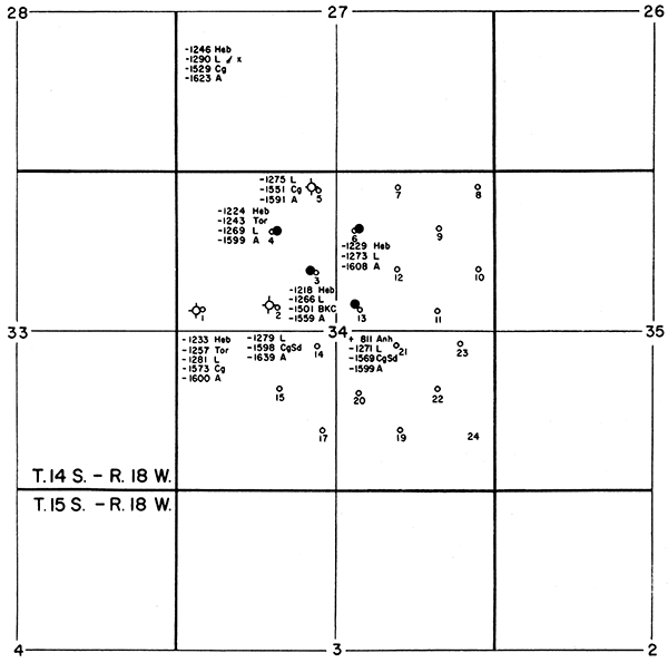
Figure 1 is a subsurface map contoured on the top of the Arbuckle limestone from well information available in October 1955. The seismic survey was intended to check this subsurface lead. Record quality was expected to permit mapping a 25- to 30-foot closure, and decision was made to proceed with the survey. Shot holes were laid out on a diagonal 20-acre grid pattern as shown by Figure 2. This control pattern was used because it was believed that the over-all probable error on the maps would be decreased by increasing control density. In other words, a more thorough evaluation of the geophysical interpretive problems could be made with additional geophysical data. Another reason for the dense control was the possibility that the areal extent of the anomaly or anomalies could be very small. Thus, it can be seen that both geologic and seismic problems were considered in laying out the control pattern.
Figure 1--Subsurface map showing approximate top of Arbuckle, Engel pool, Ellis County, Kansas. Contour interval 10 feet.
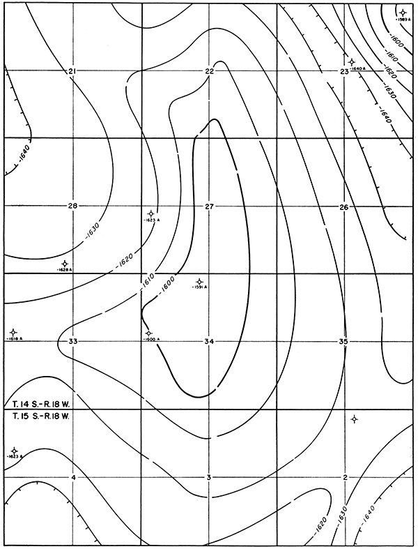
Figure 2--Plat showing shot-point locations.
The spot-correlation method, utilizing an 8-trace, triple-recorded, single-end spread, was used on this prospect. The shooting technique was based on past experience in the area and produced generally good records. The records were triple recorded so that the interpreter could study three different types of instrumental filtering on each shot. Therefore, it was possible to analyze changes in record character and, in general, to determine the cause of change.
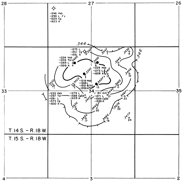
Isotime maps, rather than the conventional seismic structural maps, were used in order to eliminate errors caused by near-surface velocity variables. Further, it was judged that isotime maps between the Stone Corral (Anhydrite) and lower markers could be used for structural evaluation. This conclusion was based on the geologic premise that thinning of section is coincident with structural highs in this area. Figure 3 in an isotime map showing the time interval between the Anhydrite and an upper Pennsylvanian reflection. The map depicted in Figure 4 is based on the isotime between the Anhydrite and a reflection emanating from the Ordovician-Pennsylvanian unconformity.
Figure 3--Isotime map showing interval from Anhydrite to an Upper Pennsylvanian reflection. Contour interval .002 seconds.
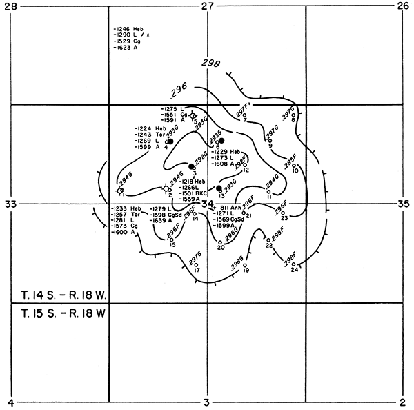
The initial drill site recommendation was shot point 3 (NE SE NW sec. 34) at the center of the small anomaly shown on Figures 3 and 4. The anomaly was drilled and found to be productive in the Lansing and Arbuckle groups. Subsequent wells on the diagonal northwest and northeast offsets to the discovery well were found to be productive in the Lansing group. The southeast offset to the discovery well also is productive in basal Pennsylvanian sand. A test was then drilled at shot point 2 (SW SE NW sec. 34) and was found to be 13 feet lower on the Lansing than the discovery at shot point 3. The Arbuckle datum also was low, indicating that the test was on the flank of the high and had encountered an erosional low typical of the area. This low was indicated on the isotime maps by 2 to 4 milliseconds of thickening.
Figure 4--Isotime map showing interval from Anhydrite approximately to Ordovician-Pennsylvanian unconformity. Contour interval .002 seconds.
This paper indicates the value of the seismic method, when properly used, for the detailed evaluation of subsurface prospects on the Central Kansas Uplift. The subsurface geology is generalized in many places, owing to lack of control, and does not show details of the severely eroded surface on the top of the Arbuckle. The additional needed control is made available by the reflection seismograph, and the pattern of erosion on the top of the Arbuckle is indicated, in general, on an approximate unconformity map. Dense control is necessary because of the small size and low relief of the structures and because seismic problems are magnified by the low structural relief of prospective anomalies.
The Engel Pool was discovered and developed by the Colorado Oil and Gas Company. The authors express their appreciation to the Colorado Oil and Gas Company for permission to publish the information presented in this paper, and to Messrs. D. G. Benson, Stewart L. Carter, Arthur W. Deaver, and Jack L. Yinger for their able help and suggestions in the preparation of this paper.
Kansas Geological Survey
Comments to webadmin@kgs.ku.edu
Web version Dec. 19, 2013. Original publication date 1959.
URL=http://www.kgs.ku.edu/Publications/Bulletins/137/Care/index.html