| Original published in W.W. Hambleton, ed., 1959, Symposium on Geophysics in Kansas: Kansas Geological Survey, Bulletin 137, pp. 175-180 | ||
Chief Geophysicist, Aero Service Corporation and Canadian Aero Service, Ltd.
The complete article is available as an Acrobat PDF file.
Two 30-mile long east-west airborne-magnetometer profiles separated by a distance of 9 miles were flown in the northern part of Morris and Wabaunsee Counties across the Nemaha Ridge; they were closed by two north-south airborne-magnetometer profiles.
Although the profiles could not be analyzed quantitatively, the magnetic data show a marked susceptibility contrast on the western approach to the Nemaha Ridge. These data agree with magnetic data along the north border of Kansas and also with a Bouguer gravity profile, which shows a marked discontinuity or level change on the approach to the Nemaha Ridge, and probably indicate that the basement west of the Nemaha Ridge consists of mafic igneous rock and the Nemaha Ridge of granite.
An airborne magnetometer loop totaling 78 miles was flown in northern Morris and Wabaunsee Counties by Frost Geophysical Corporation (now Aero Service Corporation, Mid-Continent) in June 1949 at a flight elevation 2,600 feet above mean sea level. Location of the area and the flight path are shown on Figure 2. Two 30-mile long east-west profiles, separated by a distance of 9 miles, were closed by two north-south profiles. The profiles cross portions of the Nemaha Ridge.
The magnetic data were obtained by an "inboard" wing-tip mounted Frost saturable core fluxgate magnetometer. Variations of the earth's magnetic field were recorded continuously by an Esterline Angus curvilinear recorder. These data were rectified for presentation.
The depth to the source of a magnetic anomaly is proportional to the width of the anomaly, provided the source is narrow. This principle is demonstrated in Figure 1A, which shows increase in the width of the total magnetic field intensity anomaly with increase in depth (from one to four units of depth) of an east-west horizontal cylindrical body.
Figure 1--(A) Total magnetic field intensity function for east-west striking cylinder buried 1, 2, and 4 units of depth. Inclination of earth's magnetic field 70°. (B) Total magnetic field intensity function for prismoidal bodies striking east-west having width of 6 units and buried at unit and 6 units of depth. Inclination of earth's magnetic field 60°.
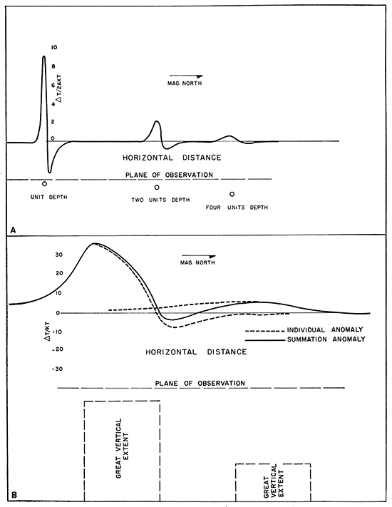
Magnetic anomalies, however, rarely are caused by horizontal cylindrical bodies. Figure 1B shows the effect on the magnetic anomaly of increased width and depth of burial of a prismatic body, as well as the influence of adjacent bodies on the magnetic field. Study of these magnetic anomalies shows that horizontal extent of maximum flank gradient is proportional to depth of burial. This criterion may be used as a guide to quantitative depth determinations if the proportionality factor is known. For simplicity, it is assumed that the anomalies are elongate and at right angles to the flight path. Details of depth determinations from aeromagnetics are given by Vacquier (1951).
Preliminary calculations for the east-west profiles showed that depth values tended to oscillate, possibly owing to (1) loss of magnetic anomaly detail because of rectification of the magnetic data from curvilinear to rectilinear co-ordinates, (2) errors resulting from the reduced scale (2 miles = 1 inch) of the magnetic profiles, and (3) invalid simplifying assumptions. The oscillation in the depth values was so marked that definite basement-depth profiles could not be established. This same condition was found in aeromagnetic studies along the northern border of Kansas, but it was possible to calculate basement level because of the length and continuity of the profile. Although quantitative analysis of these aeromagnetic profiles is not possible, a qualitative analysis is presented so that the profiles may be a part of the published record.
The general magnetic gradient of the total magnetic field rises to the east along the east-west profiles. A magnetic high of more than 100 gammas is observed in T. 15 S., R. 6 E., but a corresponding feature is not located in T. 14 S., R. 6 or 7 E. A major dual high is located in T. 14 S., R. 8 and 9 E., but a corresponding feature cannot be located on the southern profile. Regional magnetic intensity is characterized by a marked decrease in the level of magnetic intensity approximately at the boundary between R. 6 E. and R. 7 E. The change in magnetic level is about 180 gammas on the northern profile and about 200 gammas on the southern profile. A similar type of discontinuity on the approach to the Nemaha Ridge was observed on a profile along the north border of Kansas.
The major discontinuity in the level of magnetic intensity probably is caused by change in the basement from an intermediate-type igneous rock west of the Nemaha Ridge to granitic rock on the approach to the Nemaha Ridge. Also a Bouguer gravity discontinuity on the approach to the Nemaha Ridge (Woollard, 1943) probably indicates a change in basement rock type.
The major magnetic anomalies at A and B on the northern profile (Fig. 2) are interpreted as local polarization changes in basement rock. The anomaly at D probably is a minor polarization change due to a local facies change in basement rock, possibly combined with basement structure. Anomaly C is interpreted tentatively as a minor uplift on the basement; it is masked by the dual magnetic high at A and B. The minor magnetic anomalies E, F, and G on the southern profile probably are caused by shallow igneous rock.
Figure 2--Map showing location of flight path, basement depths, susceptibility discontinuity, and aeromagnetic profiles. Flight elevation: 2,600 feet above mean sea level. (After Frost Geophysical Corporation, June 10, 1949.)
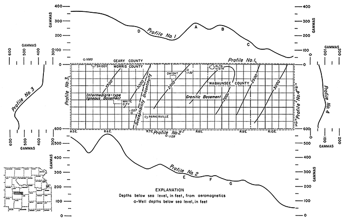
Preliminary basement depths, calculated from the aeromagnetic data of the east-west profiles, are shown with well depths on Figure 2. Minimum and maximum calculated depths were selected for comparison with well depths in order to determine whether the calculated depths are within the 20 percent error allowed for below-flight-altitude depth determinations. The minimum calculated depth is 1,900 feet below sea level; the well depth is 1,200 feet. Inasmuch as flight altitude was 2,600 feet, the error is 700 feet in 4,500 feet or about 16 percent. The calculated depth, therefore, is within the limits of error. The maximum calculated depth to basement is 3,500 feet below sea level; the well depth is 1,600 feet. The error is 1,900 feet in 6,100 feet or about 30 percent. The error far exceeds the allowable error for areal magnetometer surveys, but cannot be considered excessive for single profiles.
The aeromagnetic data in this area do not yield quantitative information, owing to reduced horizontal scale and rectification from curvilinear to rectilinear coordinates. The general structural configuration could be determined from the aeromagnetic profiles, but basement depths obtained from the magnetic data were too great by as much as 30 percent. Areal magnetic surveys undoubtedly would yield far better basement structural determinations.
The writer wishes to thank C. F. Frost, President of Frost Geophysical Corporation, for permission to publish these data.
Woollard, G. P. (1943) Transcontinental gravitational and magnetic profile of North America arid its relation to geologic structure: Geol. Soc. America, Bull., v. 54, p. 747-790.
Vacquier, V., Steenland, N. C., Henderson, R. G., and Zietz, Isidore (1951) Interpretation of aeromagnetic maps: Geol. Soc. America, Mem. 47, p. 1-151.
Kansas Geological Survey
Comments to webadmin@kgs.ku.edu
Web version Nov. 25, 2013. Original publication date 1959.
URL=http://www.kgs.ku.edu/Publications/Bulletins/137/Agocs2/index.html