![]()
Prev Page--Contents || Next Page--Stratigraphy, Leonardian
Introduction
Purpose of Study
The Permian redbeds of Kansas range in character from fine-grained shales and siltstones to fine sandstones, and the associated rocks include gray and green shales, siltstones, and sandstones, plus numerous dolomites and beds of salt, gypsum, and anhydrite. Except for the fine particle size of the clastic sediments, the Kansas redbeds are possibly typical of many of the Permian deposits in central United States and elsewhere, and therefore are judged to be worthy of detailed study.
The Permian redbeds of Kansas are the northern end of a broad area of redbeds which reaches nearly to the Pecos River in west Texas and covers half of Oklahoma (Moore, 1920). The Kansas redbeds are among the least well known outcropping rocks of the State. Their correlation with the thicker Permian section to the south and west has been discussed and argued at great length, but no petrographic description of the Kansas rocks is known. The purpose of the present study is to describe these deposits and, if possible, to discuss their origin and significance.
Inasmuch as this is not a stratigraphic study, no attempt has been made here to evaluate published correlations of Kansas deposits with the Permian rocks of Oklahoma, west Texas, or Colorado. It is hoped that the data on the Kansas redbeds accumulated here will be of some use to stratigraphers in future correlations, provided petrographic data from other regions become available.
The present economic value of the upper Permian section is almost entirely restricted to the extensive evaporite deposits. Study of the composition and texture of the redbeds themselves may indirectly disclose potential uses for them and lead to their economic development.
Scope of Study and Acknowledgments
The Permian redbeds of Kansas are included within the Leonardian and Guadalupian? Series, according to the current classification of the State Geological Survey (Moore and others, (1951). The lowermost Leonardian formation is primarily gray shale and salt, but it is included within the study because it seems to represent a lithologic transition from the older marine deposits to the redbeds proper.
The field work for this report was begun in the summer of 1948 and completed in the spring and summer of 1951. The laboratory work was started in the Mineralogy Division of the Pennsylvania State College in the autumn of 1948 and was completed in the petrography laboratory of the State Geological Survey of Kansas during 1949-1953. The study was done under the supervision of Professor Paul D. Krynine. I am also indebted to Professors J. C. Griffiths and Thomas F. Bates for criticism and advice, particularly on particle-size analyses and clay mineralogy.
Geography, Topography, Drainage, and Climate
The surface exposures of the Leonardian and Guadalupian? Series of Kansas occur chiefly in the south-central and central parts of the State. They are found in 22 counties and extend for about 185 miles east-west along the southern border of the State. The lowermost formation, the Wellington, extends in a nearly north-south direction all the way across the State from Oklahoma to Nebraska, a distance of approximately 200 miles. As the present report refers only incidentally to the Wellington formation, the area discussed is restricted to the southern part of the State (Fig. 1).
Figure 1--Areal geology of post-Wolfcampian Permian rocks of south-central Kansas. Adapted in part from Moore and Landes (1937), Norton (1939), Frye (1942), Williams and Lohman (1949), and Fent (1950). A larger version of this figure is available.
The region is traversed by U. S. Highways 160, 283, 183, 54, 281, 50S, 50N, 81, and 77, and numerous state, county, township, and section roads, particularly in the eastern part. It is served by the Atchison, Topeka, and Santa Fe Railroad; the main line of the Chicago, Rock Island, and Pacific Railroad; and the Missouri Pacific Railroad.
The entire area lies within the Great Plains physiographic province. The eastern part, comprising the older formations, is in the Wellington area and Great Bend region as defined by Frye and Leonard (1952, p. 202). The western part, which includes the Cedar Hills sandstone and younger Permian deposits, lies within the Red Hills subdivision. The Red Hills are described by Fenneman (1931, pp. 28-29) as a deeply eroded belt 10 to 20 miles wide--a ragged and picturesque escarpment 300 to 400 feet high. He notes (p. 29):
The upland level is held locally by beds of gypsum which, while very soluble in a humid climate or by circulating ground waters, make a resistant cover in a dry climate. The white gypsum, underlain by bright-red sands and shales, gives gorgeous coloring to the escarpment, already picturesque on account of its terraced canyons, jutting headlands, branching divides, and outlying buttes.
The Red Hills as mapped by Adams (1903), Schoewe (1949), and Frye and Leonard (1952) include not only the escarpment but all the exposures of redbeds from Harper and Kingman Counties on the east to the top of the Permian section in southeastern Meade County. Parts of the area of greatest relief are shown in Plate 1.
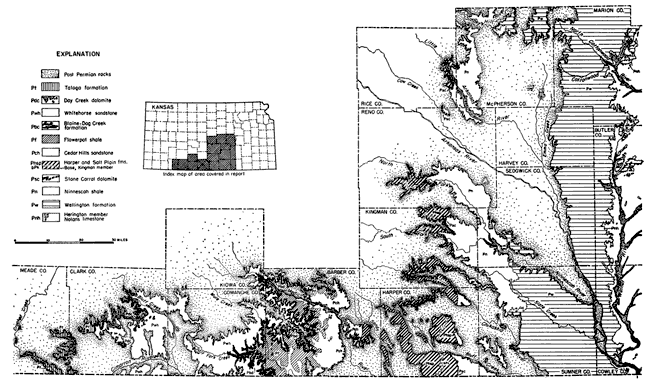
Plate 1--Topography of areas underlain by Flowerpot shale, Blaine gypsum, and Taloga formation. A, Gypsum-capped Flowerpot shale 2.5 miles south of Sun City, Barber County. B, Flowerpot Mound, sec. 26, T. 32 S., R. 13 W., Barber County. C, Rolling topography in Taloga formation, sec. 14, T. 32 S., R. 23 W., Clark County.
West of the Blaine escarpment the topography is broadly rolling (Pl. 1C) and is marked locally by minor scarps of resistant beds, such as the Day Creek dolomite. In some areas, notably in southern Barber County, multiple-generation pediments are well developed. These are noted and described by Frye and Leonard (1952, p. 205).
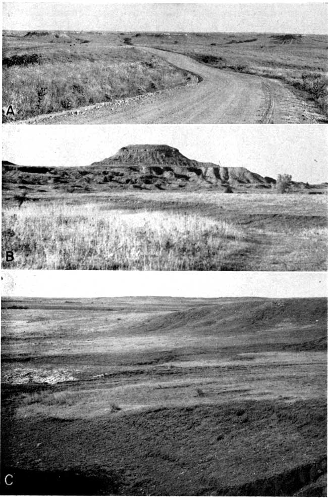
The area immediately east of the Red Hills in the Wellington area subdivision is underlain by rather weak siltstones, silty shales, and shales, and consequently is a plain of low relief, with very few good exposures except in local areas, although it consists predominantly of pediments (Frye and Leonard, 1952, p. 206). In general the only natural exposures are in low valley-side scarps, stream banks, and in some bluffs. Thin resistant beds form prominent benches in some areas (Pl. 2A).
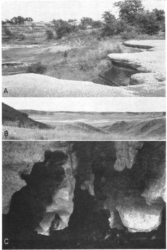
Plate 2--A, Thin resistant calcareous silty shales in lower part of Ninnescah formation; NE sec. 14, T. 35 S., R. 3 W., Sumner County. B, Big Basin, western Clark County. C, Solution features in gypsum at Natural Bridge, Barber County.
The northern part of the lower redbeds lies within the Great Bend region, where in general, Permian sediments are overlain by Pleistocene alluvial deposits and dune sand.
Solution of Permian evaporites has produced typical physiographic features in the western part of the Red Hills. Big Basin (Pl. 2B) in Clark County is one of the largest solution features in the area. It is described by Schoewe (1949, p. 305) as "a subcircular undrained depression about 100 feet deep and a mile in diameter."
Direct evidence of solution is marked in the area of the Blaine gypsum. Gypsum caves are present in Comanche and Barber counties, and natural bridges have also developed. Natural Bridge of Barber County is a well-known landmark. This bridge is about 35 feet wide and 55 feet across, and the span is about 12 feet above the level of the stream which passes under it (Schoewe, 1949, p. 303). A long, tunnel-like cave parallels the stream at this locality. A detail of the solution features in the gypsum is shown in Plate 2C. These are very similar in appearance to vadose solution features in some limestone caverns and in a gypsum cave described by Bretz (1952). Large gypsum caverns and several natural bridges occur across the state line in Oklahoma where the gypsum is thicker. The upper surface of the gypsum in some areas tends to expand during weathering and to produce small, low domes which later are broken through. These have been described as sink holes, but are not comparable with the sinks of karst regions. Bretz (1952, p. 282) attributes them to hydration of an anhydrite fraction still in the gypsum rock.
Drainage is toward the southeast. Cimarron River, Crooked Creek, and Bluff Creek drain the western part of the area (Meade, Clark, and Comanche counties). The Red Hills subdivision is drained by Salt Fork and its tributaries, chiefly Medicine Lodge River and Sandy Creek. In the area included in the Osage section the main streams are Bluff Creek, Chikaskia River, Ninnescah River, and Arkansas River. Cimarron River, Salt Fork, and Ninnescah River empty directly into the Arkansas, the first two in Oklahoma and the third in Sumner County, Kansas. Crooked Creek, Medicine Lodge River, and Chikaskia River are major tributaries to Salt Fork south of the Kansas line in Oklahoma.
The climate of the area is subhumid to semiarid, with slight to moderate precipitation, abundant sunshine, moderately high average wind velocity, and rapid evaporation. Summers are hot, and winters are moderate with occasional short severe cold periods. The mean annual precipitation ranges from 20 to 33 inches and increases from west to east. Deviations from the mean are frequent and extreme. The average annual temperature is about 56°F.
Previous Work Done on the Region
According to Marcy (1854) geologists and explorers have noted the redbeds of the southwest since the days of Marcou. Marcy himself studied the Oklahoma and Texas redbeds but did not explore those of Kansas.
The early publications referring to the redbeds of Kansas are summarized by Prosser (1897, pp. 76-83). Most of them do not include descriptions of the deposits, but simply concern themselves with correlation. Mudge's (1878) early geological map of Kansas represents the greater part of the Permian redbed area as of upper Carboniferous age, although Mudge states that west of Harper the region was little examined by himself or others. In 1883 St. John correlated the redbeds with the Cretaceous Dakota formation. This correlation was accepted by Cragin in 1885 and 1886, and the extent of the deposits was described briefly by him.
In 1887 St. John referred the redbeds provisionally to the Triassic on the basis of their stratigraphic relations and lithologic similarity to "the Triassic Red-Beds which are so well developed along the eastern foot of the Rocky Mountains a few hundred miles to the west. . . ." This assignation was followed by several later writers (Hay, 1889; Cragin, 1889; McGee, 1894).
Hay (1890) was the first to describe the redbeds in any detail. He judged them to be Jurassic-Triassic in age, but did not break them down into formations. Instead he referred to them as upper red rock, gypsum series, and lower red rock. He described lithified layers of arenaceous ferruginous limestone alternating with beds of red clay and shale; he also noted ripple marks, rain-drop impressions, and the absence of fossils, and concluded that the sediments were deposited in littoral environments. Three years later he (Hay, 1893) assigned an upper Permian age to the redbeds, on the basis of the discovery of some vertebrate fossils in northern Texas.
The first detailed stratigraphic work of a modern nature on the Kansas redbeds was that of Cragin (1896). He referred the redbeds to the Permian System and introduced 10 formation names, most of which are in current use. He also noted the general lack of stratigraphic continuity of the various beds. His classification was modified in a later paper (Cragin, 1897).
Prosser (1897, p. 82) preferred to group the redbeds into only three formations, because of the great similarity of their lithologic characters.
Some of the more recent work on the redbeds of the region has been summarized by Norton (1939, p. 1754). Gould (1901) described some vertebrate and invertebrate fossils from the redbeds of Oklahoma and noted the absence of fossils in the Kansas equivalents. Most of the subsequent reports (Gould, 1901a; Moore, 1920; Aurin, Officer, and Gould, 1926; Gould and Willis, 1927; Evans, 1931; Wilmarth, 1931; Roth, 1932; Anderson, 1933) were concerned chiefly with changes in classification of the Kansas redbeds and their correlation with Permian rocks to the south and west. Inasmuch as the present study is not concerned with problems of correlation, the literature on that subject will not be reviewed in detail. The latest published stratigraphic studies of the outcropping Kansas Permian redbeds known to me are those of Norton (1939), although several petroleum geologists have worked in the area, and a few subsurface correlation charts have been added to the literature.
Methods of Investigation
Field Work
Field work included the location of outcrops, measurement of about 60 stratigraphic sections, study of gross lithology, and collection of approximately 300 samples. In colIecting samples, an attempt was made to obtain a suite of samples representative of the deposits, but thin marker beds and rocks of unusual lithology were also collected. The importance of the latter is not great quantitatively, but they represent extremes or end-members which may help in interpretation of the geologic history.
Color designations were made in the field (and also in the laboratory) with the aid of Munsell color charts (Munsell Color Co., 1942). The National Research Council rock color charts were found to be inadequate for differentiating among the various reds and reddish browns, so the standard soil color charts (Pendleton and Nickerson, 1950) were used more extensively. Descriptive names to correspond to the numerical designations were taken from the rock color charts wherever possible; otherwise names from the soil charts were used.
Laboratory Investigation
Fifty-one thin sections were studied. Mechanical analyses of all the clastics from which thin sections had been cut were made. Mineral analyses of "light" and "heavy" separates from some of the coarser clastics were made, and the mineral composition of some of the finer-grained rocks was studied by x-ray diffraction. Diffraction was also employed in semiquantitative determination of calcite-dolomite ratios in the carbonate rocks and in cements, and it proved helpful in the rough estimation of quartz-feldspar ratios in fine siltstones.
The minus 1-micron fractions from 12 samples were studied in the electron microscope, and electron micrographs were made by Mr. C. C. McMurtry, Department of Oncology, University of Kansas School of Medicine.
Chemical analyses of 10 selected representative samples were made in the chemistry laboratory of the State Geological Survey of Kansas.
Light Microscopy
Thin sections--Seventeen of the 51 thin sections were from representative shales and siltstones. Slices were also cut from 24 sandstones and 10 evaporite specimens which were considered to be representative of the various lithologic types throughout the stratigraphic section.
Study of mineral grains--"Heavy" and "light" minerals were obtained from the sand-size fractions by bromoform separation. Heavy and light minerals were sampled by an Otto microsplit and mounted in Canada balsam for microscopic study. Light grains were also mounted in a 2: 1 glycerine-water mixture for study of grain shape and surface textures.
The heavy and light mineral slides were studied by making counts of 200 grains per slide. Roundness determinations on the quartz and feldspar grains of 14 samples were made by visual comparison with Krumbein's (1941) roundness chart. The roundness of grains from a few samples was determined from photomicrographs by actual measurement according to Wadell's (1935) method.
Mechanical Analyses
Particle-size analyses were made by a combination of sieving and pipette methods. Pretreatment of the sample depended upon the degree of cementation or induration, and varied from sample to sample. This variation affected the particle size as determined by the pipette method, and detailed comparisons of these different samples is therefore not entirely justified.
Sandstones and siltstones cemented with carbonate, and shales containing carbonate particles of silt size or larger, were broken up and leached with warm dilute (0.1 N) hydrochloric acid. Other samples were crushed carefully to pass a 500-micron screen (or coarser screen, if thin section showed coarser sand grains). Those samples which required acid treatment were washed with distilled water and acetone before dispersion. Approximately 35-gram samples were agitated for 24 hours in distilled water containing a few drops of ammonium hydroxide. They were then transferred to liter graduates, and enough water (with NH4OH) was added to make 1 liter of suspension. Analyses were carried out by pipetting at intervals of one phi unit, from 62 microns to 1 micron. Sand sizes were analyzed by shaking the sand 10 minutes in a Ro-Tap sieve shaker after decanting most of the silt and clay and drying the remainder.
Electron Microscopy
Particles from the minus 1-micron fraction were used for the electron micrographs. The particles were deposited on a Parlodion film from a dilute water suspension, and shadow-cast with chromium from an angle of approximately 17°, producing shadows 5 times as long as the height of the particles. Electron micrographs were made in an RCA EMU-2B microscope at magnifications of 6,000 to 8,000 diameters. The microscope was operated by C. C. McMurtry.
X-ray Diffraction
Diffraction patterns of most of the samples studied by x-ray were made with a GE XRD-3 spectrogoniometer. Debye-Sherrer powder-camera patterns were made from samples too small for optimum work with the spectrogoniometer.
CuKa radiation having a kvp of 50 kv at 15 ma was used for most of the spectrogoniometer and camera patterns. Where the background produced by some iron-bearing specimens was somewhat objectionable, cobalt Ka radiation was used.
Samples were crushed to pass a 62-micron screen and were packed into a specimen holder having a rectangular depression approximately 44 mm long, 13 mm wide, and slightly more than 1 mm deep. The powder was packed into the holder with the edge of a spatula, and the surface was made level by pressing down with a glass microscope slide above rough paper.
Clay mineral and chlorite analysis was made according to some of the procedures described by Brindley (1951). The methods were as follows.
1. A pattern was made from the original untreated sample.
2. A pattern was made from a glycerated sample to check for montmorillonite. Just enough glycerine was added to the powdered sample to wet it, and the paste was packed into the specimen holder with a spatula. The surface was made level and flush with the sample holder by pressing it down with wax paper under a glass microscope slide.
3. If the first patterns indicated the presence of calcite or dolomite, the carbonates were removed by treatment with cold dilute (0.05 N) hydrochloric acid. A test for vermiculite was made by boiling the sample for 5 minutes in concentrated ammonium chloride solution. If the 14 A reflection in the subsequent pattern was not affected, it was considered to represent a chlorite basal reflection rather than vermiculite. A check for kaolinite was made by destroying the 7 A chlorite reflection with hot HCl. A few oriented specimens were prepared.
Relative proportions of calcite and dolomite and quartz and feldspar were estimated roughly by comparison of relative intensities of characteristic reflections with those from standard mixtures.
No quantitative x-ray analysis of sandstones for quartz-feldspar ratios was attempted, because its impracticability is stressed by Phillippe and White (1951). They point out that grinding affects the various minerals differentially. Silt sizes of a few sands were studied.
The presence or absence of other mineral constituents, such as barite and gypsum, was noted.
Prev Page--Contents || Next Page--Stratigraphy, Leonardian
Kansas Geological Survey, Geology
Placed on web Oct. 12, 2006; originally published May. 1955.
Comments to webadmin@kgs.ku.edu
The URL for this page is http://www.kgs.ku.edu/Publications/Bulletins/111/02_intro.html