Kansas Geological Survey, Bulletin 109, part 3, originally published in 1954
Originally published in 1954 as Kansas Geological Survey Bulletin 109, part 3. This is, in general, the original text as published. The information has not been updated.
A cut-off trench excavated in 1953 by the U. S. Bureau of Reclamation at Kirwin, Phillips County, Kansas, has provided hitherto unavailable data on the Pleistocene deposits of the North Fork Solomon River Valley. The excavations cross approximately 1 mile of high terrace and reveal an abandoned and filled valley cut in Cretaceous chalks and shales. The Pleistocene deposits are classed as Grand Island and Sappa (including the Pearlette volcanic ash bed) members of the Meade formation, of Kansan age, marked in the top by the Yarmouth buried soil; the Crete-Loveland member of the Sanborn formation of Illinoian age, marked in the top by the Sangamon buried soil; and the Peoria silt member of the Sanborn formation of early Wisconsinan age. Molluscan faunas are listed from the Grand Island, Sappa, Crete-Loveland, and Peoria. These exposures show that the bedrock valley had been cut to a level below the present flood plain before deposition of the Kansan sediments.
The Pleistocene deposits of North Fork Solomon River Valley have been studied in some detail from eastern Decatur County eastward to the junction of this river with South Fork in western Mitchell County (Frye and A. R. Leonard, 1949; A. R. Leonard, 1952), particularly with regard to the quantity and quality of ground water contained in these deposits. In fact, in the lower part of this valley most of the usable supply of ground water occurs in the alluvium and terrace deposits of Pleistocene age. These strata are poorly exposed, however, and much of the knowledge concerning them has been based on widely spaced cross sections determined from test holes drilled as a part of the cooperative State and Federal ground-water program.
A dam across North Fork Solomon River Valley is currently under construction at Kirwin by the United States Bureau of Reclamation. In 1953, as a part of the construction of this dam, a cutoff trench was excavated across the high terrace on the north side of the valley, continuous with the axis of the dam; the purpose of this trench was to prevent leakage around the north end of the structure through Pleistocene channel gravels. An exceptionally fine exposure of the deposits under the high terrace was thus revealed by the excavation (Pl. 1). A study of the deposits and their contained molluscan faunas, buried soils, and volcanic ash has necessitated a reinterpretation of the early Pleistocene history of the valley.
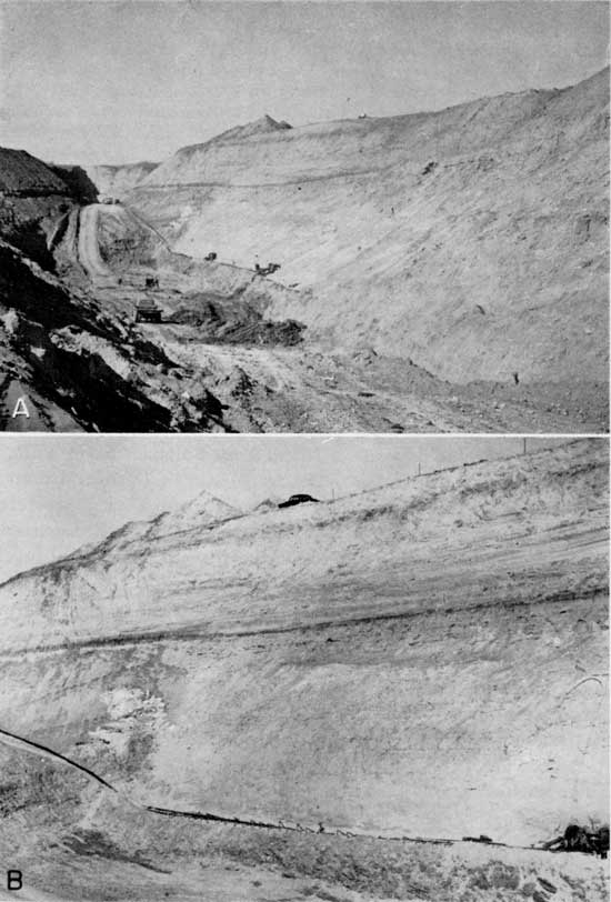
Plate 1--Cut-off trench of Kirwin dam (SW sec. 28 and SE sec. 29, T. 4 S., R. 16 W.) across high terrace at Kirwin, Phillips County, Kansas. (November 1953) A, View toward the northwest, showing deepest part of the trench. Fort Hays limestone member (Cretaceous) exposed in floor of trench in foreground. Note horizontal extent of Yarmouth soil in central part of photograph and the thinning of the Kansan deposits over the Cretaceous high in the distance. B, Part of trench wall, on the northeast side, where stratigraphic section was measured. Dark bands above the middle and near the top are the Yarmouth and Sangamon buried soils, respectively. Modern surface soil appears as a dark band at top of cut near the car and below the spoil piles.
As the work schedule of the Bureau of Reclamation calls for filling the cut-off trench with impermeable material in 1954, it seems desirable to publish a description of the Pleistocene deposits immediately so that interested persons may have an opportunity to examine the exposures before they are covered by the trench filling, even though a detailed study of related deposits in other parts of the valley has not yet been possible.
Particular thanks are expressed to Charles Osborne and C. T. Jamison of the Bureau of Reclamation for calling to our attention the existence of these significant exposures and accompanying us in a field examination. The U. S. Bureau of Reclamation is generously making available to the State Geological Survey data obtained by its test drilling.
North Fork Solomon River flows in a general easterly direction from Thomas County across parts of Sheridan, Decatur, Norton, Phillips, Smith, and Osborne counties to its junction with South Fork in northwestern Mitchell County to form Solomon River. In its headwaters, the valley is cut into the Pliocene Ogallala formation; downstream, Cretaceous rocks first occur at the surface in western Norton County. From eastern Norton County to the junction with South Fork, the valley slopes are developed predominantly in the Cretaceous Niobrara formation and Carlile shale. A prominent late Wisconsinan terrace is observable throughout most of the length of the valley and has been mapped in Norton County (Frye and A. R. Leonard, 1949) and across Phillips, Smith, and Osborne counties (A. R. Leonard, 1952), where it was named the Kirwin terrace. Recent alluvium underlies the flood plain and is marked in the lower course of the valley by a distinct, though low, flood-plain terrace. Throughout the course of the valley, late Pleistocene loess mantles the upland and much of the valley slope area, the loess becoming thinner eastward.
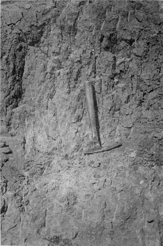
Plate 2--Yarmouth soil in cut-off trench at Kirwin dam. Detail of soil profile shown at left side of photograph in Plate 1B. Upper 0.5 foot (A horizon) friable massive to granular loam, dark gray-brown; 0.5 to 2 feet (B horizon) prismatic, tough sandy clay loam, dark gray-brown grading downward to a grayish-tan; 2 to 3.5 feet (C horizon) massive with irregular but strong accumulation of calcium carbonate, tan to light-gray. Shells of fossil mollusks in lower part of zone of calcium carbonate accumulation. (November 1953)
Although these general aspects of the geology of the valley have been interpreted clearly, the recognition and correlation of high terraces has been handicapped by their fragmentary nature, lack of exposures, and the general blanket of loess. Frye and A. B. Leonard (1952) described this valley as presenting a physiographic sequence of terraces--that is, the oldest terrace at a relatively high position on the valley sides, the Illinoian terrace at a lower level, and the Wisconsinan (Kirwin) terrace at a still lower position. Evidence from the new exposures at Kirwin requires some modification of this earlier interpretation.
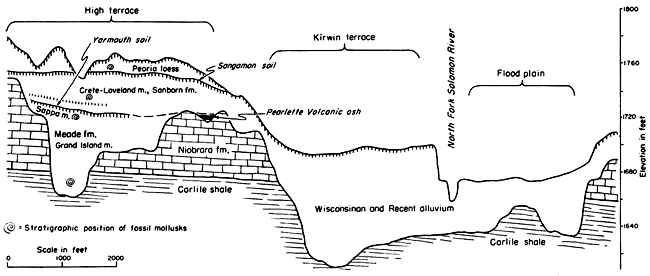
The North Fork Solomon bedrock valley presented an apparent constriction at Kirwin before excavations were made; natural exposures of Cretaceous chalk (Fort Hays) are found on both sides of the valley in this area above the Kirwin terrace. The slightly dissected loess-covered surface which extends northwestward presents no bedrock outcrops. Not until the Bureau of Reclamation drilled a series of test holes across this surface was it discovered that the area is underlain by a maximum thickness of 120 feet of Pleistocene deposits which fill an abandoned valley of the river (Fig. 1). This abandoned valley segment occurs in an arcuate pattern, leaving the present valley west of Kirwin and returning to it east of Kirwin. The present valley, cut in bedrock, was formed by post-Illinoian erosion after the stream had shifted southward across a former low spur of Cretaceous rocks.
Figure 1--Generalized cross section across North Fork Solomon River Valley and adjacent high terrace at Kirwin, Phillips County, Kansas. Based on test hole data and cross sections furnished by the U.S. Bureau of Reclamation.
The shifting of the stream southward at this location has contributed to exceptionally fine preservation of the Pleistocene fill, as it has been protected from erosion by the main stream. Post-Kansan deposition by side-slope wash and minor stream action buried a sizable area of Yarmouth soil (Pl. 2) without removal of the A horizon.
Figure 1 shows that the bedrock valley occupied by Kansan sediments extends well below the level of the surface of the late Pleistocene Kirwin terrace. The Illinoian deposits overlie uneroded Yarmouth soil at the valley-wall end of the excavation. Adjacent to the present valley, the Yarmouth soil is absent and basal gravels of the Crete member, coarser than at the valley-wall end, rest directly on eroded Kansan sediments. This suggests that by Illinoian time the major stream had shifted southward nearly halfway from its Kansan position to its present location.
The stratigraphic section described below was measured in the northeast wall of the trench starting in the area of lowest bedrock in the abandoned valley (PI.1).
| Kirwin dam section, measured in cut-off trench excavation in the high terrace of North Fork Solomon River Valley, SW sec. 28 and SE sec. 29, T. 4 S., R. 16 W., Phillips County, Kansas; November 1, 1953. | Thickness, feet |
|||
|---|---|---|---|---|
| Quaternary--Pleistocene | ||||
| Sanborn formation--Peoria silt member (Wisconsinan Stage, Iowan-Tazewellian Substages) | ||||
| 9. | Silt, massive, well-sorted, calcareous (except surface 0.5 foot), light-tan; contains transition zone in base above contact on Sangamon soil; lower part oxidized to pale pinkish-tan; terrestrial gastropods in middle part | 10.0 | ||
| Crete-Loveland member (Illinoian Stage) | ||||
| 8. | Silt, sand, and clay, massive to thinly bedded and crossbedded, light-brown to tan; coarser in lower part; contains lentils of sand and chalk gravel and locally coarse cross-bedded gravel at base; middle and upper parts relatively poorly sorted with thin dispersed sand and gravel lentils. Top 2.5 feet is Sangamon soil--upper 0.5 foot (A horizon) friable brown silt loam; 1 foot (B horizon) light-brown silty clay loam with well-developed prismatic structure; 1 foot (upper C horizon) massive light-brown sandy silt with sparse lime mottling along joints and dispersed lime nodules. Five weakly developed soils occur below the Sangamon soil-upper 4 soils pale pinkish-brown, less than 1 foot thick, with weak textural contrast and structures; lowermost soil, 5 feet above base, nearly 2 feet thick with silty clay loam B horizon (Pl. 3B). Terrestrial gastropods occur sparsely throughout lower half | 32.0 | ||
| Meade formation (Kansan Stage) | ||||
| Sappa member | ||||
| 7. | Silt and sand; lower 1 foot massive tan sandy silt contain- ing terrestrial and fresh-water gastropods. Yarmouth soil (Pl. 2) profile in upper 3.5 feet; upper 0.5 foot (A horizon) friable gray-brown massive to granular loam; 1.5 feet (B horizon) dark gray-brown sandy clay loam with strongly developed prismatic structure; 1.5 feet (C horizon) massive silt and sand, dark gray-brown at top to tan, with lime mottling throughout but concentrated in upper part, lime nodules rare | 4.5 | ||
| Grand Island member (66.5 feet) | ||||
| 6. | Sand and gravel, lenticular and interbedded fine and coarse with a few silty zones; contains pebbles and cobbles (up to 1 foot or more in diameter) of Cretaceous chalk; and sand and fine gravels predominantly of quartz, feldspar, and granitic grains similar to those of the Ogallala formation farther west. Discontinuous zone of yellow-brown limonitic staining at top. At the southeast end of the trench a lentil of Pearlette volcanic ash 2 to 3 feet thick occurs near the top of this interval above high Cretaceous bedrock | 42 | ||
| 5. | Silt and fine sand, well-sorted, thin-bedded to laminated, locally intricately cross-bedded in zones 1 to 3 inches thick, tan to gray-tan. laterally replaced by sand and gravel | 4.5 | ||
| 4. | Silt, sand, and clay, massive, hi a persistent zone of lentils; black, dark-gray, and tan; dark organic coloring distributed lenticularly through zone; calcareous throughout. Locally sand and gravel occur in this zone. Shells of terrestrial gastropods throughout | 5.0 | ||
| 3. | Sand and gravel, cross-bedded, lenticular, gravels predominantly of Cretaceous chalk; similar in lithology to unit 6 above | 5.0 | ||
| 2. | Silt, sand, and clay, massive, black to gray-brown, calcareous, similar in lithology to unit 4 (Pl. 3C). Occurs as discontinuous lentils in sand and gravel; contains shells of terrestrial gastropods | 2.0 | ||
| 1. | Sand and gravel, cross-bedded, lenticular; contains pebbles and cobbles of Cretaceous chalk. Coarser textured than unit 3 above and locally gradational with it. | 8.0 | ||
| Thickness of exposed Pleistocene deposits | 113 | |||
| Cretaceous--Gulfian | ||||
| Carlile shale-Blue Hill shale member | ||||
| (Penetrated by bottom of sump at lowest point in floor of excavated trench. Fort Hays chalk member of Niobrara formation exposed in floor of trench at higher elevations) | ||||
The relatively narrow steep-sided Kansan valley is judged to have been filled rapidly by an aggrading stream in late Kansan time. The lower part of the fill contains a disconnected series of humic silty lentils (Pl. 3C) that suggest pauses in the movement of gravels through the valley and the filling by finer materials of active or abandoned channel segments. The bulk of the Kansan fill, however, to within a few feet of its top (Pl. 3B) consists of coarse gravel, predominantly derived from Cretaceous chalky limestones similar to the bedrock of the valley walls; it is free of silt or clay lentils and thus indicates relatively continuous rapid alluviation. The upper part of the fill grades into silty sand, which suggests a lessening of the vigor of the alluviating stream.
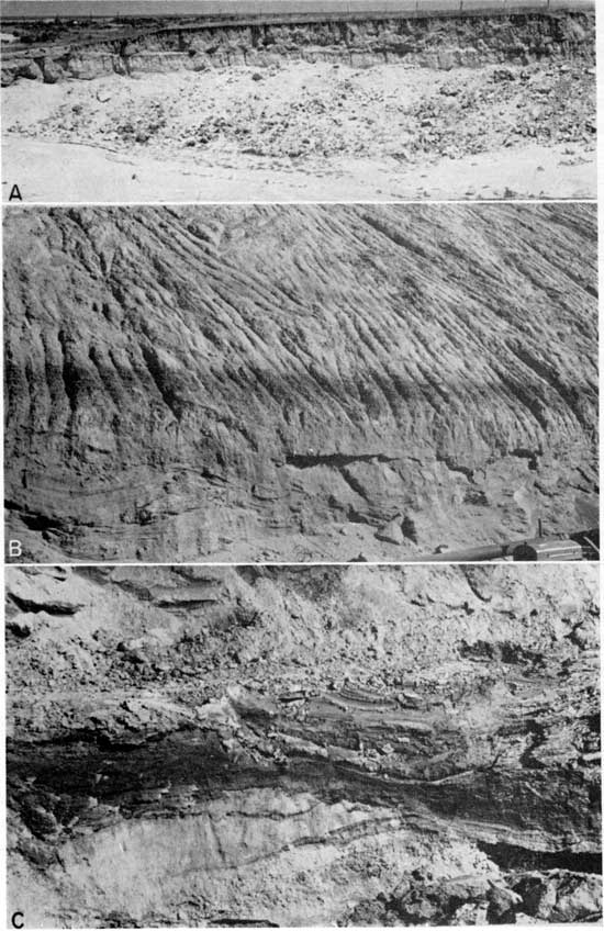
Plate 3--Fossiliferous Kansan deposits near Portis, Osborne County, and in cut-off trench of Kirwin dam, North Fork Solomon River Valley. A, Gravel pit southwest of Portis, Osborne County (NW sec. 11, T. 6 S., R. 13 W.), in Kansan deposits underlying a high terrace remnant on south side of North Fork Solomon River. Measured section by A. R. Leonard (1952, p. 39); fossil snails listed in Figure 2. (June 1951). B, Sappa and uppermost Grand Island member, Meade formation, with Yarmouth soil profile in top, overlain by Crete-Loveland member of Sanborn formation, in Kirwin dam cut-off trench. Fossil snails occur in C horizon of Yarmouth soil and lower in the Sappa member, and in the lower half of the overlying Crete-Loveland member. Note weakly developed soil in Crete-Loveland about 5 feet above Yarmouth soil. (November 1953) C, Humic sandy silt clay lentil in lower part of the Grand Island member, Meade formation, in deepest part of cut-off trench of Kirwin dam. Fossil snails in this and adjacent lentils. Bed 2 of measured section. (November 1953)
In the upper part of the Meade formation (Kansan) a lentil of fresh and relatively pure volcanic ash is exposed in the southeastern part of the trench. Ada Swineford has examined samples of this ash and makes the following statement concerning it (personal communication): "The volcanic ash is very fine-grained and unaltered. The shape of the shards, the vesicles, and the refractive index of the glass are characteristic of the Pearlette volcanic ash bed."
A thin bed of clay occurs in the northwestern end of the trench a short distance below the Yarmouth soil profile and in the same stratigraphic position as the Pearlette volcanic ash. Ada Swineford has examined samples of this clay by x-ray diffractometer, using nickel-filtered copper radiations, and describes it as follows (personal communication):
The predominant clay mineral is montmorillonite with minor amounts of illite and kaolinite. About 15 percent calcite is present and less than 5 percent quartz. The deposit is probably a result of weathering of a thin lentil of impure Pearlette volcanic ash, which occurs in relatively unweathered condition farther along the cut.
The exceptionally well-preserved Yarmouth soil profile that caps the Kansan cycle of sediments is the most unusual feature of these exposures. Nowhere in northwestern Kansas has a more completely preserved Yarmouth soil been observed. This profile (Pl. 2) is approximately 3 1/2 feet thick and indicates a mature development under grass cover with moderate to moderately poor drainage.
The Illinoian cycle of sediments, classed as the Crete-Loveland member of the Sanborn formation, is significant. The texture of the sediments suggests that the main channel at this time was situated south of the position of the Kansan channel and that the bulk of the Crete-Loveland sediments was derived from valley side wash, minor streams, and perhaps in part from colluviation. The sediments in this part of the trench are poorly sorted, ranging from coarse sand to clay, and contain five recognizable, although weakly developed, buried soil profiles. The preservation of the A horizon of these soils, as well as that of the underlying Yarmouth soil, is consistent with a position removed from major stream action.
A Sangamon buried soil, typical of hundreds of exposures of this soil examined in north-central Kansas, occurs in the top of the Illinoian sediments.
The overlying Peoria loess is also typical in texture, color, thickness, and distribution of the widespread Peoria exposures in this part of the State.
Assemblages of fossil gastropods were found in the cut-off trench at four stratigraphic positions. In addition, a poorly preserved skull of a large squirrel (Cynomys, prairie dog) was found associated with a weathered zone in the lower part of the Illinoian deposits. A few worn teeth were recovered from this specimen. A limb bone from some large mammal was discovered by one of the workmen in the course of excavating the Grand Island gravels, but we did not see this fossil. Samples of sediments from several levels were examined for the presence of fossil pollen by Mr. Roland Anderson, graduate student in the Department of Botany at the University of Kansas, but no pollen grains were found; spores of mosses and of fungi were observed in the humic lentils in the lower part of the Grand Island depositional cycle. Seeds of Chenopodium (common pig weed) or some similar plant were recovered in considerable numbers from the C horizon of the Yarmouth soil, where they occurred with numerous shells of gastropods. Among these organic remains, only those of the gastropods are of stratigraphic significance.
An adequately diagnostic assemblage of fossil gastropods was collected from each of the several stratigraphic units exposed in the trench (Fig. 1) including an assemblage from the lower part of the Grand Island sediments, but some gastropod faunas are meagerly represented both in kinds and in actual numbers. The stratigraphic distribution of fossil mollusks from sediments exposed in the trench is shown in Figure 2, which also lists for comparison the faunal assemblages from Kansan deposits at two other localities in North Fork Solomon River Valley.
Figure 2--Diagram showing the distribution of fossil mollusks in the several stratigraphic units exposed in the cut-off trench at Kirwin. Faunal assemblages from two additional exposures of Kansan deposits along the course of North Fork Solomon River are included for comparison. The Norton County locality is in the NW sec. 19, T. 5 S., R. 22 W.; the Osborne County locality is in the NW sec. 11, T. 6 S., R. 13 W.
| Norton County |
Osborne County |
Fossil Mollusks | Phillips County, SE sec. 29, T. 4 S., R. 16 W. |
|||
|---|---|---|---|---|---|---|
| Kansan | Kansan | Illinoian | Wisconsinan | |||
| Grand Island |
Sappa | Grand Island |
Sappa | Crete- Loveland |
Peoria | |
| Pupilla blandi Morse | ||||||
| Succinea avara Say | ||||||
| Gastrocopta armifera (Say) | ||||||
| Pupilla muscorum (Linne) | ||||||
| Valonia gracilicosta Reinhardt | ||||||
| Gastrocopta mcclungi Hanna & Johnson | ||||||
| Gastrocopta procera (Gould | ||||||
| Pupoides albilabris (C.B. Adams) | ||||||
| Stenotrema leai leai (Binney) | ||||||
| Succinea grosvenori Lea | ||||||
| Aplexa hypnorum (Linne) | ||||||
| Hawaiia miniscula (Binney) | ||||||
| Helosoma trivolvis (Say) | ||||||
| Hendersonia occulta (Say) | ||||||
| Gyralus cristatus Leonard | ||||||
| Gyralus labiatus Leonard | ||||||
| Gyralus similaris (Baker) | ||||||
| Lymnaea bulimoides Lea | ||||||
| Lymnaea caperata (Say) | ||||||
| Lymnaea palustris (Muller) | ||||||
| Menetus pearlettei Leonard | ||||||
| Physa anatina Lea | ||||||
| Promenetus umbilicatellus (Cockerell) | ||||||
| Valvata tricarinata (Say) | ||||||
| Vertigo modesta (Say) | ||||||
| Vertigo ovata Say | ||||||
| Gastrocopta cf falcis Leonard | ||||||
| Gastrocopta proarmifera Leonard | ||||||
| Helicodiscus parallelus (Say) | ||||||
| Helicodiscus singleyanus (Pilsbry) | ||||||
| Vallonia pulchella (Muller) | ||||||
| Amnicola limosa parva Lea | ||||||
| Carychium perexiguum Baker | ||||||
| Deroceras aenigma Leonard | ||||||
| Discus cronkhitei (Newcomb) | ||||||
| Euconulus fulvus (Muller) | ||||||
| Gastrocopta contracta (Say) | ||||||
| Gyraulus pattersoni Baker | ||||||
| Pisidium compressum Prime | ||||||
| Retinella electrina (Gould) | ||||||
| Valvata lewisi Currier | ||||||
| Vertigo milium (Gould) | ||||||
| Zonitoides arboreus (Say) | ||||||
Grand Island assemblage--Eleven species of terrestrial gastropods occur in dark-gray to black humic lentils within the lower 15 to 20 feet of the Grand Island sediments. The assemblage, while not rich in kinds nor abundant as individuals, is characteristic of assemblages of gastropods known. to occur elsewhere in Kansan deposits (Fig. 2; Frye and A. B. Leonard, 1952, fig. 7). Gastrocopta mcclungi, reported by Hanna (1913) from unidentified Pleistocene deposits in Phillips County near Long Island, has not been found subsequently in sediments of known age within the Pleistocene. The species occurs here also in Illinoian sediments.
The molluscan fauna recovered from the Grand Island sediments in the excavation contains small terrestrial species, indicating that the humic-stained lentils were deposited in temporary depressions on the flood plain of the Kansan Solomon river; the absence of any aquatic species suffices to show that these depressions were not filled with water for periods longer than a few weeks at most.
Sappa assemblage--Nineteen species of fresh-water and terrestrial gastropods occur in Sappa sediments in the C horizon of the Yarmouth soil profile. The assemblage is characteristic of late Kansan molluscan faunas at other localities in the western Missouri River Valley (Frye and A. B. Leonard, 1952, fig. 7), but several diagnostic species, such as Carychium perexiguum, Deroceras aenigma, Gyraulus pattersoni, Euconulus fulvus, and others found at one or both of the other known Kansan faunal localities in the North Fork Solomon Valley, do not occur here. Reasons for this are not apparent.
It may be assumed that the greater part of the shells in this assemblage were redeposited from small ponds, since most of the shells are representative of species that live in such places, but a few which are characteristic of prairie and prairie-border situations probably were washed into the trench from valley slopes. Among the aquatic gastropods, Gyraulus cristatus has not been recorded previously from Pleistocene sediments in northwestern Kansas. The living representatives of this species are widely distributed in Europe and in northern North America from Maine west to Alberta and northward in Canada.
A total of 29 species occurs in Kansan sediments in the trench, a number which compares favorably with faunal assemblages recovered from Kansan deposits elsewhere. It should be emphasized that neither here nor at the Norton County locality (Fig. 2) is there any significant or consistent difference between molluscan assemblages in Grand Island and Sappa deposits.
The lower part of the Crete-Loveland sediments exposed in the excavation contains a meager molluscan faunal assemblage of six species of terrestrial gastropods. Gastrocopta mcclungi has not been reported previously from Illinoian deposits; the remaining species are characteristic of Illinoian faunal assemblages elsewhere (Frye and A. B. Leonard, 1952, fig. 8) but comprise only a small part of the total known faunal assemblage in Illinoian sediments of the Kansas region.
The lower part of the Peoria loess above the transition zone contains five species of diminutive terrestrial gastropods. The assemblage, although small, is characteristic of the Iowan faunal zone in Wisconsinan sediments in Kansas and elsewhere (A. B. Leonard, 1952,p.11).
Exposures made available in the cut-off trench across the high terrace at the north end of the Kirwin dam, Phillips County, afford the most complete sequence of middle and late Pleistocene deposits so far studied in northwestern Kansas. Except at the Iowa Point section in Doniphan County (Frye and A. B. Leonard, 1949), no exposure in Kansas affords a superior sequence of molluscan faunal assemblages. The Kansan deposits classed as Grand Island and Sappa members (including the Pearlette volcanic ash bed) of the Meade formation and terminating in the Yarmouth buried soil constitute the bulk of the fill of an abandoned early Pleistocene valley and contain two distinctive molluscan faunas. The Illinoian sediments are particularly distinguished by the presence of five buried soils which indicate six episodes of deposition separated by short intervals of relative stability. None of these soils compares in degree of development with the Sangamon soil which was formed after Illinoian deposition, but the lowermost soil contained within the cycle of Illinoian deposition is well enough developed to indicate requirement of a significant interval of time. At no other place in Kansas is the series of minor buried soils within the Crete-Loveland sediments so clearly displayed.
The configuration of the bedrock at Kirwin demonstrates (1) a post-Ogallala, pre-Kansan episode of valley trenching that reduced the bedrock floor to a position below the present channel level, followed by (2) valley filling through Illinoian time and (3) a post-Sangamonian interval of vigorous valley trenching, followed by (4) late Wisconsinan alluviation.
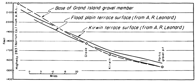
Elsewhere in North Fork Solomon River Valley diagnostic molluscan faunas have been collected only from exposures in a road cut on U. S. Highway 283, southeastern Norton County, and from a gravel pit southwest of Portis, Osborne County. By utilizing data from these three localities and by the reinterpretation of cross-section data at Glade (A. R. Leonard, 1952, pl. 3, B-B'), a schematic profile of the bedrock floor of the Kansan valley has been constructed and plotted with profiles prepared by A. R. Leonard (1952, fig. 3) for the Kirwin terrace surface through this segment of the valley. These profiles (Fig. 3) show that the topographic sequence of valley fills is inverted downstream from Norton County, suggesting the headward migration of an over-steepened channel segment, or knickpoint, between Kansan and Wisconsinan time. These data emphasize the complex nature of the relationships of Pleistocene terraces in Great Plains valleys, and the hazards that are involved in age correlation based on elevation above present channels, and even by the tracing of alluviated surfaces.
Figure 3--Profiles along North Fork Solomon River Valley. Data for the Kirwin terrace and flood plain are from A. R. Leonard (1952). The gradient of the bedrock floor of the Kansan age river (based on four control points) has cross cutting relationships both to the present flood plain and the Kirwin terrace surface.
Frye, J. C., and Leonard, A. Byron (1952) Pleistocene geology of Kansas: Kansas Geol. Survey, Bull. 99, pp. 1-230. [available online]
Frye, J. C., and Leonard, Alvin R. (1949) Geology and ground-water resources of Norton County and northwestern Phillips County, Kansas: Kansas Geol. Survey, Bull. 81, pp. 1-144. [available online]
Hanna, G. D. (1913) A Pleistocene molluscan fauna from Phillips County, Kansas: Univ. Kansas Sci. Bull., vol. 7, no. 3, pp. 111-121.
Leonard, A. Byron (1952) Illinoian and Wisconsinan molluscan faunas in Kansas: Univ. Kansas, Paleon. Contri., Mollusca, art. 4, pp. 1-38.
Leonard, Alvin R. (1952) Geology and ground-water resources of the North Fork Solomon River in Mitchell, Osborne, Smith, and Phillips Counties, Kansas: Kansas Geol. Survey, Bull. 98, pp. 1-150. [available online]
Kansas Geological Survey, Geology
Placed on web Jan. 6, 2009; originally published in April 1954.
Comments to webadmin@kgs.ku.edu
The URL for this page is http://www.kgs.ku.edu/Publications/Bulletins/109_3/index.html