
3-D Seismic Applications by Independent Operators in Kansas
Susan Nissen, Kansas Geological Survey
Kirk Rundle, Consulting Geophysicist
Richard Lockhart, Lockhart Geophysical Company
Ernest Morrison, Mull Drilling Company
Executive Summary
3-D seismic data has been successfully used by independent operators in Kansas over the last decade to identify prospects and make drilling decisions. The estimated commercial success rate for wells drilled with 3-D seismic is 70%, compared to an average success rate of approximately 30%-35% for wildcat wells drilled in Kansas over the past 3 years. 3-D seismic has been particularly useful for delineating small structural highs and narrow channels that can be significant drilling targets, but cannot be identified with well-control alone or even using 2-D seismic data. Two examples of 3-D seismic successes in Kansas are shown: a new structural feature with Arbuckle production that was discovered on the Central Kansas Uplift, and a paleo-valley (or scour) feature containing Chester sandstones in the South Eubank Field, Haskell County. Although independent operators in Kansas have had significant success using 3-D seismic for making structural interpretations, there are issues with reservoir quality and production that cannot be answered with structural information alone. These issues can potentially be addressed using attributes related to the shape, amplitude, and lateral coherence of the seismic waveform. A university-industry consortium is currently being formed to identify methodologies for incorporating additional information from seismic attributes into an integrated reservoir characterization and to evaluate the applicability of 3-D seismic attribute analysis techniques to improve exploration and development success in Kansas.
Introduction
Independent operators have been acquiring 3-D seismic data in Kansas for approximately 10 years. To date, over 400 square miles of 3-D seismic data have been acquired by small- and moderate-sized oil companies throughout Central and Western Kansas, with an average survey size of approximately 3-4 sq. mi. Lockhart Geophysical Company, one of the seismic acquisition contractors working in Kansas, currently acquires approximately 20-25 sq. mi of 3-D seismic data per month, primarily in Central Kansas. Table 1 shows acquisition parameters for a typical seismic survey in Central Kansas. Frequency content of the resulting data is normally in the range of 16-110 Hz.
| Table 1. Typical 3-D seismic acquisition parameters | |
| Energy source: | Vibroseis |
| Sweep frequency: | 28-128 Hz |
| Bin size: | 82.5 x 82.5 ft |
3-D seismic has become a common piece of information used by Kansas operators for identifying prospects and making drilling decisions. 3-D seismic data has been used to image practically every exploration objective in western Kansas, including delineation of incised valley-fill reservoirs (e.g., Montgomery, 1996; Montgomery and Morrison, 1999) and identification of local structural features that could not be properly identified with well-control alone, or even with a combination of well and 2-D seismic data. Many of the prospects in Kansas have been structural plays, where 3-D seismic time-structure and interval time-thickness maps have been valuable tools in locating small structural highs. Along the Central Kansas Uplift, in particular, there has been a great deal of success using 3-D seismic to identify topographic relief related to karst development at the top of the Arbuckle, resulting in the discovery of several significant Arbuckle and Lansing-Kansas City oil reservoirs. It is estimated that the commercial success rate for wells drilled from 3-D seismic data is approximately 70%. This is considerably higher than the average success rate of approximately 30%-35% for wildcat wells drilled in Kansas over the past 3 years. Table 2 lists some recent discoveries where the use of seismic was specifically credited for the discovery.
| Table 2. Recent Discoveries Credited to 3-D Seismic | ||||||
Company |
Well |
Location |
County |
Producing interval |
Product |
Source |
| Pelican Hill Oil & Gas | #1-35 Young | 35-T17S-R24W | Ness | Marmaton/Fort Scott | oil | Kansas Geological Society Bulletin September-October 2002, p. 36 |
| Murfin Drilling Company | #4-25 Rusco-Davis | 25-T11S-R20W | Ellis | Arbuckle | oil | Kansas Geological Society Bulletin November-December 2002, p. 33. |
| Imperial American Oil Corp. | #30-1 Evelyn #30-1 Verna Unit |
30-T12S-R16W | Ellis | Lansing-Kansas City | oil | Kansas Geological Society Bulletin May-June 2003, p. 33. |
| Murfin Drilling Company | #1-5 Keller (Bowman) | 5-T11S-R19W | Ellis | Lansing-Kansas City | oil | RedTop Monthly News Service v.19, issue 4 April 10, 2003 |
| Vess Oil Corporation | Denton 'A' #1 | 1-T32S-R24W | Clark | Arbuckle | oil | RedTop Monthly News Service v.19, issue 11 November 10, 2003 |
Examples
Arbuckle Structure – Central Kansas Uplift
Figures 1 and 2 illustrate a new structural feature that was discovered on the Central Kansas Uplift with 3-D seismic. The operator of the lease outlined by the bold black line (Figure 1) joined a larger 3-D project as a paying participant. At the time of data acquisition, the quarter section lease contained one dry hole, two abandoned producers, and was producing 4 BOPD from the only remaining productive well. There is a known Arbuckle structural high to the E-SE of this lease. Figure 1 shows a structure map (in seismic travel time) of the top of the Arbuckle, as interpreted from the 3-D seismic. High areas are in red and lows in blue. This Arbuckle Time Map reveals a considerable westward and northward extension of the known structure. Deep faulting is apparent on the seismic profile (Figure 2), which creates the opportunity for rapid structural reversal in the area. The profile intersects three new producing wells drilled in the immediate area based upon the 3-D data. Two new wells have been drilled to date in the quarter section of interest. The initial production for each new well in the quarter section outlined is approximately 70 BOPD. This has served as a great example of the benefits of operators of old producing properties becoming paying participants in 3-D projects that are conducted immediately adjacent to their leases.
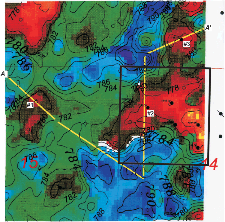 |
| Figure 1. Arbuckle Time Map covering an area of approximately 1 sq. mi on the Central Kansas uplift. Structural highs are red and lows are blue. Contour Interval = 2 ms. The location of seismic profile A - A' in Figure 2 is shown by the yellow line. |
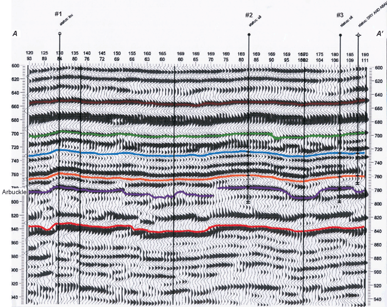 |
Figure 2. Seismic profile A - A' from the 3-D seismic volume on the Central Kansas Uplift intersecting three new producing wells that were drilled based upon the 3-D seismic. |
Chester Formation – South Eubank Field, Haskell County,
KS*
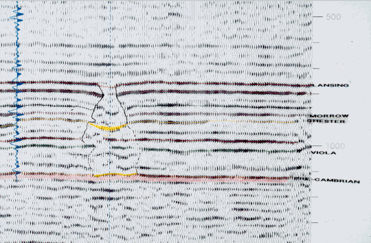
This study covers portions of T29S-R34W and T30S-R34W in Haskell County, Kansas. The study area is located in the Hugoton Embayment of the Anadarko Basin and lies within the boundaries of the Permian producing Hugoton Gas field, where various operators are now in the process of drilling for deeper Pennsylvanian and Mississippian pay horizons. The Eubank Field is on the north end of the study area and the Victory Field is on the southeast end of the area. The Eubank Field was discovered in 1958 and the Victory Field was discovered in 1960. Mississippian-age Chester sandstones are one of the main pay zones in these fields. Chester reservoirs are best developed in fine-grained, well-sorted sandstones filling a narrow north-south trending incised paleo-valley system (or scour). In addition to the Mississippian Chester, production is found in the Pennsylvanian Lansing, Kansas City, Marmaton, Cherokee, and Morrow and the Mississippian St. Louis (Figure 3). The Chester series disconformably overlies the St. Genevieve or in some cases the St. Louis. At the deepest scour cut the St. Genevieve is absent. The Chester is unconformably overlain by the Pennsylvanian-age Morrow series.
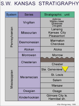 |
| Figure 3. Typical section for the Mississippian and Pennsylvanian in southwest Kansas. Note the downcutting of the Chester into the Meramac. |
Early deep drilling in this area used the shallow “Hugoton” wells to project the structure on the deeper features. The presence of two to three shallow wells per section allowed for good control on the Permian horizons. In the 1980’s Mesa Petroleum conducted an extensive 2-D seismic shoot across the area. The 2-D seismic worked well for major structures but did not image the smaller structural features or the scour features where Chester sandstones may have been deposited. In 1994 the drilling of the Clawson #1-9 in section 9-T29S-R34W discovered a Chester scour feature. As developmental drilling progressed it was evident that 3-D seismic would be a tool that could enhance the success of locating these narrow channel scours. A 26 square mile 3-D seismic survey was shot to help define the subtle features that make up the Chester reservoir in this area. The design of the shoot was made to take advantage of the known structural orientation of this area. The bin size of the survey is 110 ft by 82.5 ft with the 110 ft y-axis in a north-south direction. This design allowed for the imaging of the narrow-width scour features. The 3-D interpretation indicates a regional fault on the west side of the shoot and a scour feature that is the length of the survey (Figures 4 and 5). Hugoton Energy Corporation drilled 14 successful wells in succession within this major scour feature. Many of the features that are visible on the 3-D are small but the seismic has allowed Hugoton Energy Corporation to identify and drill these features with a high degree of success. The major scour feature is less than 1000 feet wide in most places. The 3-D seismic also indicates a series of karsted features that are visible in the Chester and other deeper horizons (Figures 5 and 6). To date, the karsted features have not been tested.
 |
| Figure 4. 3-D seismic data volume from South Eubank Field with the Chester horizon surface superimposed. |
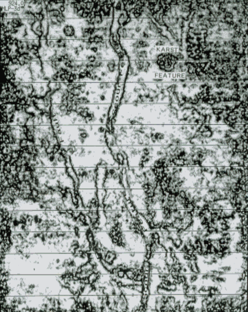 |
| Figure 5. Seismic coherence time slice at 924 ms through the South Eubank Field 3-D seismic survey, showing a regional fault, a major Chester scour feature, and a karst feature. |
 |
| Figure 6. Seismic profile through the karst feature in the South Eubank Field 3-D seismic survey. |
To see PowerPoint presentation of the Chester example, check the website: http://www.kgs.ku.edu/Workshops/IVF2000/eubank-ivf/index640.html
*Acknowledgment is given to Mark Grommesh for the 3-D seismic interpretation and to Jim Gowens with Hugoton Energy Corporation (Chesapeake Energy) for making the South Eubank data available for publication.
What's Next?
Although independent operators in Kansas have had significant success using 3-D seismic for making structural interpretations, there are issues with reservoir quality and production that cannot be answered with structural information alone. Attributes related to the shape and amplitude of the seismic waveform and volume-based multi-trace attributes related to vector dip of coherent energy have the potential to provide more in-depth information about the reservoir. Such seismic attributes have been used elsewhere to identify the distribution and orientation of fractures, delineate karst dissolution features, and, when integrated with core and log data using statistical tools or neural networks, predict detailed spatial distribution of rock and/or fluid properties within the reservoir. Therefore, the next potential step for enhancing the value of 3-D seismic in Kansas is to identify methodologies for incorporating additional information from these seismic attributes into an integrated reservoir characterization. A university-industry consortium is currently being formed to evaluate the applicability of 3-D seismic attribute analysis techniques to Kansas datasets and reservoir challenges. A suite of seismic attributes will be generated using commercially available software, as well as new, state-of-the art tools under development at the University of Houston. Geologic and petrophysical analyses of well data and analysis of subsurface engineering data will be conducted. Seismic attributes will be integrated with geological and engineering data using statistical and neural net tools available as freeware in the Intelligent Computing System (ICS), developed by Luff Exploration Company under DOE project DE-FC26-00FT15123 (http://www.luffdoeproject.com). The ICS tools have been applied by Luff Exploration Company for analysis of carbonate reservoirs in the Red River Formation, Williston Basin, North Dakota. The tools were used to transform multiple seismic attributes into reservoir attributes (e.g., predicted porosity-thickness) using data from wells as training control. Reservoir attributes were, in turn, combined with production data to produce maps of production attributes (e.g., predicted initial producing oil-cut), highlighting areas of maximum oil reserves and productivity. Such reservoir characterization using ICS tools allowed Luff Exploration to successfully target horizontal wells and re-develop several old fields (Sippel, 2002; 2003). As part of the Kansas 3-D Seismic Attributes Consortium, the methodology used by Luff Exploration in the Williston Basin carbonate reservoirs will be tested on both carbonate and clastic reservoirs in Kansas, and the suitability of using the methodology in these geological settings will be assessed.
References
Montgomery, S. L., 1996, Stewart Field, Finney County, Kansas: Seismic definition of thin channel reservoirs: AAPG Bulletin, v. 80, p. 1833-1844.
Montgomery, S. L., and E. Morrison, 1999, South Eubank Field, Haskell County, Kansas: A case of field redevelopment using subsurface mapping and 3-D seismic data: AAPG Bulletin, v. 83, p. 393-409.
Sippel, M., 2002, Intelligent computing software enables independent to delineate thin reservoirs: American Oil and Gas Reporter, Feb., p. 100-ff.
Sippel, M., 2003, Reservoir characterization from seismic
and well control with intelligent computing software: AAPG Annual Convention
Abstracts, http://www.searchanddiscovery.com/documents/abstracts/annual2003/extend/79991.PDF
Updated January 2003