 |
|
Kansas Geological Survey Open-file Report 2003-82 |
Chapter 2: Coal Deposits of the Cherokee Basin
Previous work by Harris (1984) and Stanton (1987) divided the Cherokee Group into ten stratigraphic intervals using laterally persistent dark-gray to black “core” shales as stratigraphic markers (Figure 2.01). These highly radioactive black shales (150-300+ API units) are readily identifiable on gamma-ray well logs and are correlatable throughout eastern Kansas and into adjacent states. These “hot” gamma-ray shales serve as marker beds for the major coals within the study area. A composite section illustrates the stratigraphic relationship between marker beds and other units used in the study (Harris, 1984; Figure 2.02). In this study, an additional interval (Little Osage interval) was added above the Cherokee Group. The Little Osage interval contains the Summit coal of the Fort Scott Limestone a significant coal and important exploration target in southeast Kansas (Figure 2.01).
Depositional environments in the Cherokee Group range from relatively deep, low energy marine environments to shallow, marginal marine and nonmarine environments. Due to significant hiatus before and after peat development, depositional environments of coals may not be directly related to the environments of the overlying or underlying sediments (McCabe, 1984). Depositional environments of coals may be better reflected by their geometry, average thickness, areal extent, orientation, ash content, and sulfur content (Flores, 1993, McCabe and Shanley, 1992).
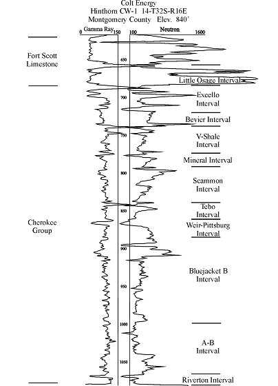 |
Figure 2.01 - Type log of the Cherokee Group and lower Fort Scott Limestone in the Cherokee Basin with designated intervals defined by marker beds, which are primarily dark gray to black shales (after Staton, 1987).
|
Composite Section of the Cherokee Group
|
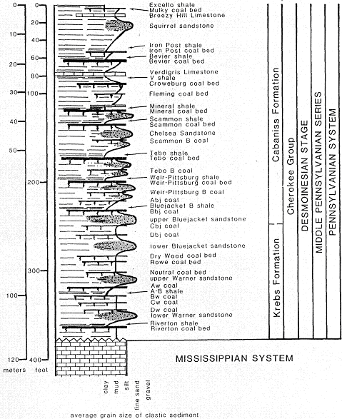 |
| Figure 2.02 - Composite section of the Cherokee Group in southeastern Kansas showing relationship of marker beds, which are primarily dark gray to black radioactive shales and major named coals (modified from Harris, 1984) |
2.1 Lithofacies and Depositional Environments of the Cherokee Group
Ten lithofacies were recognized in the Cherokee Group of southeast Kansas
(Table 2.1). The depositional environment of each lithofacies was interpreted
based on mineralogy, sedimentary structures, ichnology, log response and stratigraphic
position of described cores (Table 2.1; Appendix 1). Individual lithofacies
are listed below, along with an interpretation of the depositional process
and sedimentary environment.
Table 2.1 - Facies scheme for
the Cherokee Group in the Cherokee basin. |
||
Lithofacies |
Depositional Process |
Sedimentary Environment |
| Coal to carbonaceous shale | Peat growth | Mire |
| Blocky mudstone | Pedogenesis | Paleosol |
| Pyritic shale | Sediment fallout | Coastal marsh-swamp |
| Interlaminated sandstone and siltstone | Tidal currents and slack-water sediment fallout | Marginal marine |
| Sideritic gray shale | Sediment fallout and low-energy tidal currents | Marginal marine |
| Laminated muddy sandstone | Tidal currents and slack-water sediment fallout | Muddy tidal flat |
| Bioclastic packstone to grainstone | Reworking by waves or tides and bioturbation | Marine, above fair-weather wave base |
| Bioclastic mudstone to wackestone | Bioturbation | Open marine, below fair-weather wave base |
| Dark gray shale | Storm action and sediment fallout | Offshore transition |
| Phosphatic black shale | Sediment fallout | Low oxygen shelf |
e-mail : webadmin@kgs.ku.edu
Last updated January 2004
http://www.kgs.ku.edu/PRS/publication/2003/ofr2003-82/chapter2.html