 |
|
Kansas Geological Survey Open-file Report 2003-82 |
1.2 Hydrocarbon Significance
Conventional petroleum production in the Cherokee basin began in the late 19th century and continues to present. Production has been in decline for the past fifty years and is presently dominated by stripper production (Newell et al., 2002). Production of shale gas in eastern Kansas from carbonaceous black shales from the Fort Scott member of the Marmaton Group dates back to 1910, where wells are reported to have produced more than 200 million cubic feet (MMCF; Charles and Page, 1929). Today, these carbonaceous black shales are known as the Little Osage and Excello Shale, and occur in association with thin underlying coals (Summit and Mulky, respectively; fig. 1.01). Exploration for shale and coal gas briefly resurged in the late 1980’s due to tax incentives and then subsided in the early 1990’s during persistent low commodity prices. In the first three years of the 21st century, recent demands for natural gas, increased price, and new technologies have turned unconventional gas in the Cherokee basin into an active energy play (Figure 1.02). Up to 14 relatively thin coals beds may be encountered in any one well (Brady, 1997). The key to a successful coalbed play is to identify numerous coals of sufficient thickness with higher adsorbed gas contents (greater than 100 standard cubic feet per ton) located near pipeline infrastructure (Figure 1.02).
Coals in the Cherokee basin are generally less than 2,500 feet deep (760 m), so drilling costs are relatively low. Top reported completion intervals are in the Mulky coal and overlying Excello Shale, Weir-Pittsburg coal, and Riverton coal.
Many producers are producing gas from coals that are less than 2 feet (0.6 m) thick with promising results. Current unconventional gas production in southeast Kansas is rapidly increasing and exceeds 1.5 BCF per year (billion cubic feet; Priestman, 2003).
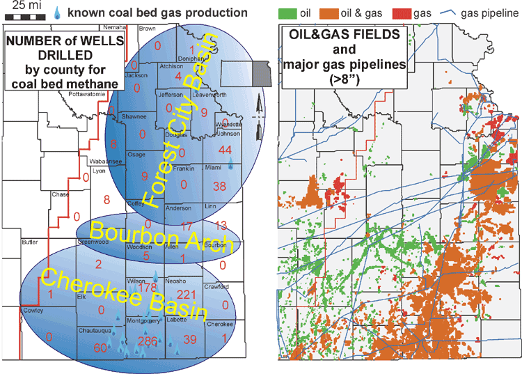 |
| Figure 1.02 Coalbed methane wells drilled and major pipeline infrastructure |
e-mail : webadmin@kgs.ku.edu
Last updated January 2004
http://www.kgs.ku.edu/PRS/publication/2003/ofr2003-82/chapter1-2.html