Kansas Geological Survey, Open File Report 96-49
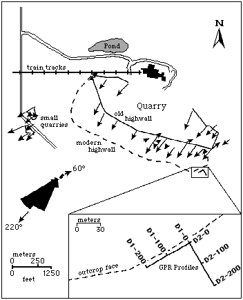
The skeletal oolitic grainstone facies (a reservoir analog) is thickest and best exposed in the Heartland Cement quarry near Independence, Kansas (the site of this study; Figs. 1 and 2) where it is approximately 15 m thick. This facies consists of a range of lithologies from nearly pure, well sorted oolite to poorly sorted oolitic fossiliferous grainstone and a small amount of packstone (Feldman et al., 1993). The main body of the oolite is well exposed in the mile-long (1.6 km) highwall of the Heartland Cement quarry and consists of thick (1.0-1.3 m) tabular, planar cross-beds at the base of the oolite that grade upwards to thinner, trough cross-beds at the top (Feldman et al., 1993). Current orientations are predominantly to the southwest with a minor mode to the northeast (Hamblin, 1969; Fig. 2). There is also an increase in shale content upward in the uppermost 3 m of the Drum Limestone in the quarry. Troughs are separated by shale drapes that grade upward into isolated troughs surrounded by shale.
Figure 2--Map of the Heartland Cement quarry showing highwall locations, cross-bedding dip directions, and location of GPR lines D1 and D2 with respect to the modern highwall (modified from Feldman et al., 1993). Stations 0, 100, and 200 are also indicated along the GPR lines in the detailed map.