Kansas Geological Survey, Open-file Report 96-11
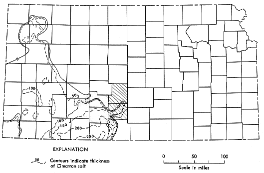
The Cimarron Salt (Lower Permian) is a relatively thin rock salt stratigraphically situated within the upper part of the Ninnescah Shale (Fig. 1). The Cimarron Salt is present only in the south-central and southwestern regions of Kansas. However it extends southward into Oklahoma where it is much thicker and more expansive (Jordan and Vosburg, 1963). In Kansas, the salt attains maximum thicknesses of approximately 76 m (250 ft) in Clark and Comanche Counties (Fig. 2). Locally, the Cimarron salt has been extensively leached and is believed to be a possible source for ground water contamination in portions of Kansas (Cobb, 1980; Cobb, 1983; Gillespie and Hargadine, 1992).
Figure 1. Generalized columnar section of geologic units in study area (Gillespie, 1992)
| System | Series | Geologic Unit | Maximum thickness, in feet |
Physical Characteristics |
| Quaternary | Pleistocene | Undifferentiated Pleistocene deposits |
300 | Unconsolidated deposits of sand and gravel with interbedded lenses of clay, silt, and caliche. Windblown silt (loess) and dune sand occur at the surface over most of the area. Stream-laid deposits (alluvium) of late Quaternary age range from clay to gravel and occur along the South Fork Ninnescah River valley |
| Permian | Lower Permian | Salt Plain Formation | 300 | Reddish-brown sandy siltstone and fine-grained sandstone |
| Harper Sandstone | 250 | Brownish-red siltstone with a few thin beds of silty sandstone |
||
| Stone Corral Sandstone | 20 | White and light-gray anhydrite and dolomite |
||
| Ninnescah Shale | 400 | Red and grayish-green shale, siltstone, and very fine-grained silty sandstone. A 20 to 50 foot thick salt member, when present, is about 50 feet below the top of the formation |
||
| Wellington Formation | 500 | Calcareous gray and blue shale, containing thin beds of anhydrite, gypsum, and limestone. The Hutchinson Salt Member, when present, is near the middle of the formation |
||
Figure 2. Broad-scale map of the Cimarron Salt with the location of Stafford and Pratt Counties highlighted (modified from Bayne, 1972).
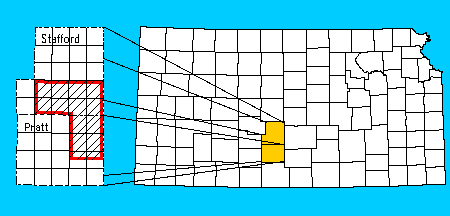
The study discussed here, centered on southern Stafford and northern Pratt Counties, was undertaken in order to improve our understanding of the north-eastern edge of the salt body (Figures 2 and 3). The project involves using more than 500 well logs to map the extent and thickness of the Cimarron Salt.
Figure 3. Location of the study area.
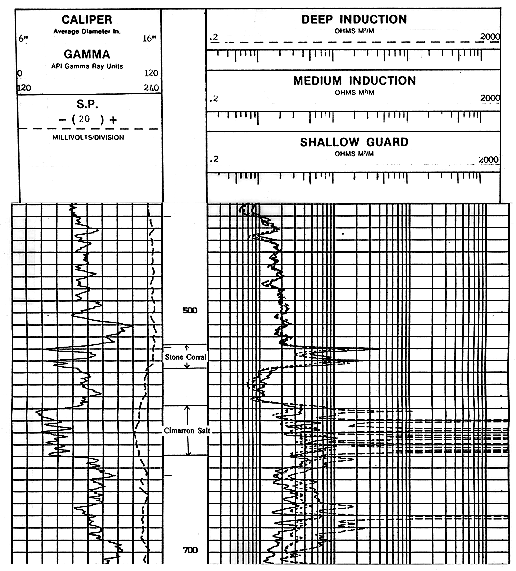
Maps of the salt body were constructed using approximately 500 geophysical well logs. Several factors influenced the selection of well logs. The logs had to include both the overlying Stone Corral Formation and the underlying Wellington Formation (Fig. 1). Also, gamma ray, guard and neutron logs were used whenever possible (instead of older electric logs). A well density of one well per square mile was deemed adequate for most areas. In areas where residual salt is very thin, well density was increased to better determine its extent. Figure 4 shows a sample log and the geological horizons associated with it.
Figure 4. Gamma and induction logs from Deutsch Oil Co. #2-27 Scholes (27-27S-11W).
The horizon information from the well data were entered into a spreadsheet and then were contoured using the program Surface III on a workstation.
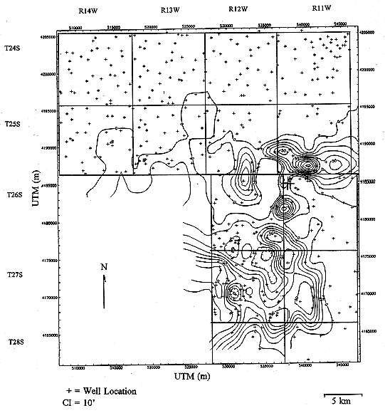
The location and thickness of the Cimarron Salt as mapped in southern Stafford and northern Pratt counties are shown in Figure 5. In the study area, the Cimarron Salt varies in thickness over short distances and has an irregular edge. Remaining salt bodies have weak NW-SE to NE-SW trends. A thin residual of salt is preserved in the extreme southwestern portion of Stafford County. Earlier studies (Bayne, 1972; Fig. 2) had the zero edge of the salt further to the west on the eastern edge of Stafford County (Fig. 5).
Figure 5. Isopach map of the Lopwer Cimarron Salt.
The top of the overlying Stone Corral Formation was also mapped (Fig. 6). A linear trend analysis was performed on these data. The results of the removal of the linear trend are shown in Figure 7. The areas of residual highs correspond closely to the overall shape of the underlying salt body, making trend analysis a possible tool for discernment of underlying salt bodies.
Figure 6. Contour map of the top of the Stone Corral Formation (relative to sea level).
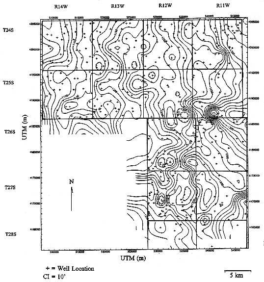
Figure 7. Positive residuals of linear trend analysis of the top of the Stone Corral Formation.
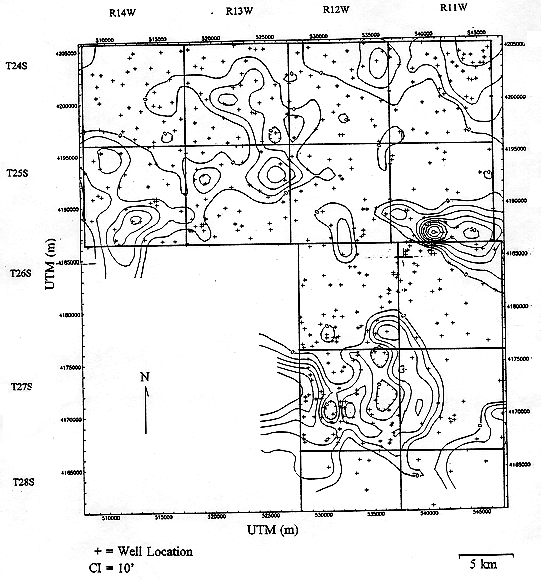
The distribution of the Cimarron Salt in Kansas is important because the salt is a possible source for ground water contamination due to leaching. The results of the study indicate that the salt extends further to the east than previously thought, has an irregular edge, and that remaining salt bodies have weak NW-SE to NE-SW trends. The overlying Stone Corral may be used as an indicator of the presence or absence of the Cimarron Salt, at least along its perimeter.
The authors wish to thank J. Gillespie of the USGS for the use of well log information from an earlier study USGS in the area.
The data used in theis project is available for downloading. Two ASCII versions are available--one comma-delimited and one tab-delimited. In each of these files, missing values are indicated by -999.
Bayne, C. K. (1972) Supplemental areas for storage of radioactive wastes in Kansas: KGS Special Distribution Publication, No. 60, p. 1-20.
Cobb, P. M. (1980) The distribution and mechanisms of salt water intrusion in the fresh water aquifer and in Rattle Snake Creek, Stafford Co., KS: KGS Open File Report 80-17, pp. 1-176.
Cobb, P. M. (1983) Current and possible future hazards to irrigation in Kansas: an overview of salt water intrusion from Permian formations: KGS Open File Report 83-3, pp. 1-12.
Gillespie, J. B., and G. D. Hargadine (1992) Geohydrology and saline ground water discharge to the south fork Ninnescah River in Pratt and Kingman Counties, south-central Kansas: Unpublished USGS Water Resources Investigations Report, pp. 1-93.
Jordan, L. and D. L. Vosburg (1963) Permian salt in the Anadarko Basin, Oklahoma and Texas: Oklahoma Geological Survey, Bulletin No. 102, pp. 1-76.
Kansas Geological Survey, Open-File Report 96-11
Placed online Sept. 1996
Comments to webadmin@kgs.ku.edu
URL=http://www.kgs.ku.edu/PRS/publication/OFR96_11/cim1.html