 |
|
Kansas Geological Survey Open-file Report 2003-51 |
Resource Assessment
 |
| Net Coal Isopach Map (C.I. = 1 ft.) |
The net coal isopach (shown above) includes “major,” laterally correlative coals in the region.
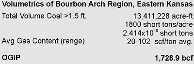
The volumetrics report below is a summation of volumetric calculations of all “major” coals as in the net coal isopach map above. The Scammon, Dry Wood, and Aw coals are not included due to insufficient desorption data.
Gas Analysis

(Modified from Jenden et al., 1988)
Jenden et al. (1988) plotted the methane dD vs. methane d13C values (lower graph) of several conventional gas samples from around Kansas, concluding that eastern Kansas Pennsylvanian gases are of three different origins (thermogenic, microbial CO2 reduction, and microbial). Coalbed gas samples from eastern Kansas plot within a zone of mixed thermogenic-microbial origin. The upper graph of % wetness vs. methane d13C also supports a mixed origin for coalbed gas.
Preliminary results of ongoing research at the Kansas Geological Survey suggest that separate dominantly thermogenic and dominantly mixed microbial gas fairways may exist in the deeper and shallower parts, respectively, of eastern Kansas
|
|
|
e-mail : webadmin@kgs.ku.edu
Last updated October 2003
http://www.kgs.ku.edu/PRS/publication/MidAAPG2003-1/P3-02.html