Kansas Geological Survey, Open-file Report 2004-37
by
Dana Adkins-Heljeson, Lawrence L. Brady,
Timothy R. Carr, and Justin P. Penka
Kansas Geological Survey
KGS Open File Report 2004-37
Sept. 2004
This data review and compilation was supported in part by the U.S. Geological Survey, Department of the Interior, through their National Coal Resources Data System program under assistance award #02ERAG0064. Project officers--M. D. Carter and S. J. Tewalt, and coalbed methane geologists--R. C. Milici and J. A. Luppens are specifically acknowledged.
The views and conclusions contained in this document are those of the authors and should not be interpreted as necessarily representing the official policies, either expressed or implied, of the U.S. Government.
Exploration for and the production of natural gas from coal (termed coalbed methane or CBM in the report) continues to develop rapidly in eastern Kansas and especially in southeast Kansas. During this study period 1774 wells were determined to have been drilled for exploration or production of coalbed methane since the start of CBM activities in eastern Kansas. Of this total 973 wells were recognized to be producing CBM in eastern Kansas. Production of CBM during 2003 totaled approximately 10 billion cubic feet. This production total is mainly from four counties (Montgomery, Neosho, Wilson, and Labette counties) within the Cherokee basin of southeast Kansas. Two additional counties with significant CBM production include Chautauqua and Miami counties.
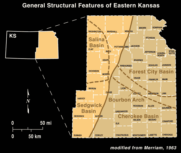
The most active area of CBM exploration and production continues to be within the Cherokee Basin; however, new exploration and evaluation is still taking place in the southern and the northern areas of the Forest City basin in Kansas. All of this CBM activity is within the two basin areas and the Bourbon arch area between the Cherokee and Forest City basins (see Fig. 1).
Figure 1--General location of the Forest City and Cherokee basins in eastern Kansas, and the Bourbon arch area that separates the two basins. All coalbed methane activity in Kansas is present in these two basins and the Bourbon arch. Production is mainly from the Cherokee basin.
The two main objectives of the CBM data compilation study were to recognize existing wells drilled in the exploration, testing, and production of coalbed methane, and to add new wells and production data to a database as the information becomes available. Information that goes into the CBM database includes the following well data as agreed in the original proposal with the U.S. Geological Survey. This information for the CBM database includes the following --
Basic information for the CBM database came primarily from state agencies--the Kansas Corporation Commission (the state regulatory agency on Kansas oil and gas production) and from the Kansas Department of Revenue. Industrial sources for additional information include "scout cards," geophysical logs, geologist reports, and company information.
During the CBM data compilation project, effort was taken to recognize which new wells and wells previously entered into the Kansas Geological Survey (KGS) oil and gas information data are CBM wells; information on these wells was then compiled into the database. Distribution of the 1774 wells recognized as coalbed methane wells in Kansas is shown in figure 2. Of this total, 973 wells are recognized as wells producing CBM, and those are present on 847 lease blocks. Location of the lease blocks having CBM production is shown in figure 3. Production data is reported by producers to the Kansas Department of Revenue as production on a given lease block, and this is the way individual production data is shown in the database. There is usually one producing well per lease block; however, the number of producing wells per lease block is shown in the database. The key information on all CBM wells and on the producing leases is entered into an Oracle database that exists at the KGS for all oil and gas wells in the state. This information is available to the public on the KGS website at https://apps.kgs.ku.edu/web/qualified/index. Key information on these CBM wells and production leases has been tabulated into Microsoft Excel spreadsheets and this information is available as two separate files on the CD-ROM enclosed in Appendix A.
Figure 2--Location of the coalbed methane exploration and production wells in eastern Kansas that have been recognized, and the information on the ACO-1 forms entered into the KGS database. A total of 1774 wells were entered in the database through July 31, 2004.

Figure 3--Location of the coalbed methane production leases in eastern Kansas that have been recognized, and for which information has been obtained from the Kansas Department of Revenue and entered into the KGS database. A total of 847 leases were entered in the database through July 31, 2004.
Information from the Kansas Corporation Commission, Oil and Gas Conservation Division, on well completions has about a four-month delay before receipt of the Well Completion Report (Form ACO-1) at the Kansas Geological Survey. These forms are scanned and the data entered into the Oracle database following checking of the data. A copy of a blank ACO-1 form that is completed by the operator for each well is shown in Appendix B. A scanned copy of the original completed ACO-1 form for each CBM well submitted by a petroleum company is available on the website for recently completed wells.
The KGS, in determining the production of oil, gas, and coalbed methane, uses production data by lease obtained from the Kansas Department of Revenue. The production data has a four to five month delay before it becomes available to the KGS.
An example of information compiled in the KGS website database is shown in Appendix C. The specific example shown in Appendix C is a new well selected for Township 29S, Range 18E, Section 22, Neosho County, Kansas. Ten wells, including four coalbed wells, are present in Section 22. For purposes of presenting the data obtained for most CBM wells, one well was selected from the four CBM wells in Section 22, Well--API: 15-133-25761. Information available for this well includes--1) all well data, 2) headers of wireline logs run on the well, 3) scanned images of the logs (not included in the report), 4) production data showing annual and monthly production of the latest year with cumulative annual production on older wells, 5) submitted well completion form (ACO-1), casing and perforation records, and 6) drillers log.
The information shown in Appendix C, and listed in the above paragraph, will be available for the CBM wells on the KGS website; however, some of the information will not be available on the two summary CBM database files compiled using the Microsoft Excel format (Appendix A).
The compilation effort for this study was completed mainly by the efforts of Dana Adkins-Heljeson, Research Assistant, and Justin P. Penka, Student Assistant. Coordination and direction of the project was by Co-Principal Investigators--Timothy R. Carr, Senior Scientist, and Lawrence L. Brady, Senior Scientist.
Merriam, D. F., 1963, The geologic history of Kansas: Kansas Geological Survey Bulletin 162, 317 p.
Both Excel files are available in a PK-ZIP archive: ofr2004_37.zip
Compiled Data of CBM wells in Eastern Kansas
Compiled data of 1774 wells recognized as CBM wells in eastern Kansas. These wells include all wells used for exploration, testing, and production of CBM. The CD-ROM containing this data file was entered on an Excel spreadsheet and utilizes 26 columns of information. Further details of individual wells are available on the KGS website at https://apps.kgs.ku.edu/web/qualified/index.
| Column Listing of Data on General CBM Wells in Eastern Kansas | ||
|---|---|---|
| Column | Name | Comments |
| A | KID | Unique identification number assigned by KGS |
| B | API_NUMBER | -- |
| C | LEASE_AND_WELL | Lease name and well# |
| D | FIELD | Field name to which well is assigned by Kansas Corp. Commission. |
| E | LATITUDE | -- |
| F | LONGITUDE | -- |
| G | TOWNSHIP | -- |
| H | TWN_DIR | In Kansas, all Townships are south of Latitude 40° |
| I | RANGE | -- |
| J | RANGE_DIR | Range direction from 6th Principal Meriden |
| K | SECTION | -- |
| L | SPOT | Section subdivision |
| M | FEET_NORTH | Distance north from designated (O) section corner |
| N | FEET_EAST | Distance east from designated (O) section corner |
| O | FOOT_REF | Reference section corner for direction in M and N |
| P | OPERATOR | -- |
| Q | ELEVATION | -- |
| R | ELEV_REF | Elevation reference |
| S | DEPTH | Depth of well in feet |
| T | FORM_AT_DEPTH | Formation at bottom of well (where listed) |
| U | SPUD | Date of initial drilling of well |
| V | COMPLETION | Date of well completion |
| W | PLUGGING | Date that the well is plugged |
| X | OIL_KID | Unique id # for oil production from well--assigned by KGS |
| Y | GAS_KID | Unique id # for gas production from well--assigned by KGS |
| Z | STATUS | CM is designated for CBM wells |
Compiled Data of Production Leases having CBM wells in Eastern Kansas
Compiled data of 847 production leases recognized as containing one or more CBM wells in eastern Kansas. These data contain general production information of CBM leases in eastern Kansas. The CD-ROM containing this data was entered on an Excel spreadsheet utilizing 23 columns of information. Further details of individual leases and additional information on the multiple wells (if more than one) in the lease are available on the KGS website at http://www.kgs.ku.edu/Magellan/Field/lease.html.
| Column Listing of Data on Production CBM Leases in Eastern Kansas | ||
|---|---|---|
| Column | Name | Comments |
| A | LEASE_KID | Unique lease identification # assigned by KGS |
| B | LEASE | Lease name |
| C | DOR-CODE | Kansas Dept. of Revenue code # |
| D | API_NUMBER | API # for the first well in the lease. For API# of Other wells in the lease--check KGS Website |
| E | FIELD | Producing CBM wells assigned to general basin areas--Cherokee Basin Coal Area, or Forest City Coal Gas Area * |
| F | PRODUCING_ZONE | Coals (where listed) |
| G | OPERATOR | -- |
| H | TOWNSHIP | -- |
| I | TWN_DIR | In Kansas, all Townships are south of Latitude 40° |
| J | RANGE | -- |
| K | RANGE_DIR | Range direction from 6th Principal Meriden |
| L | SECTION | -- |
| M | SPOT | Section subdivision (where listed) |
| N | LATITUDE | (where listed) |
| O | LONGITUDE | (where listed) |
| P | YEAR | Year that production started |
| Q | MONTH | Month not reported on EXCEL, month details available on website database |
| R | OIL_PRODUCTION | -- |
| S | OIL_WELLS | -- |
| T | OIL_CUMULATIVE | -- |
| U | GAS_PRODUCTION | Annualized production |
| V | GAS_WELLS | Gas wells in that specific lease. Where blank or 0 are shown (as recorded in DOR files), were counted as one well because of production |
| W | GAS_CUMULATIVE | Total cumulative production to end of last year |
* At the present time CBM production is assigned to either the Cherokee Basin Coal Area or the Forest City Coal Gas Area. The Bourbon Arch area shown in the structure map of figure 1 is not recognized separately in Kansas CBM production nomenclature.
Counties included in the Cherokee Basin Coal Area include: Allen, Bourbon, Butler, Chase, Chautauqua, Cherokee, Cowley, Crawford, Elk, Greenwood, Labette, Montgomery, Neosho, Wilson, and Woodson.
Counties included in the Forest City Coal Gas Area include: Anderson, Atchison, Brown, Coffey, Doniphan, Douglas, Franklin, Jackson, Jefferson, Johnson, Leavenworth, Linn, Lyon, Miami, Morris, Nemaha, Osage, Pottawatomie, Shawnee, Wabaunsee, and Wyandotte.
The ACO-1 is available as an Acrobat PDF file, courtesy of the Kansas Corporation Commission: aco1.pdf (260 k).
Kansas Geological Survey, Energy Research
Updated Sept. 14, 2004
Comments to webadmin@kgs.ku.edu
The URL for this page is HTTP://www.kgs.ku.edu/PRS/publication/2004/OFR04_37/index.html