 |
|
Kansas Geological Survey Open-file Report 2003-29 |
Flowpath Modeling
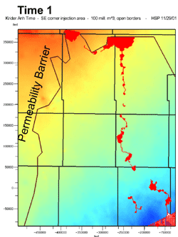
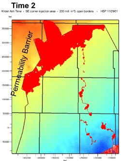
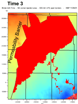
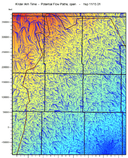
Maps based on the Hugoton Project horizon data provide a very high detailed look at the structure and thickness at all the flow and barrier units in the embayment. A structure map on the anhydrite of the Stone Corral Formation (Leonardian) was used as a datum to remove post-Permian deformation, which is primarily tilting downward to the east during the Cretaceous-Tertiary Laramide deformation. A flow path ray-tracing model was used to examine migration of oil and gas through major reservoir intervals including the Permian Chase (Krider Member); Lansing-Kansas City (Missourian) and Mississippian (Meramecian). Flowpath models assume that petroleum flows against a well-defined surface (e.g. a regional seal) and that migration is solely buoyancy driven (i.e. updip). Flowpath models enable fast, high-resolution processing of map-based models. The models assume a constant porosity and permeability throughout the reservoir intervals, and hydrocarbons are injected at the lowest structural point. There are no fault paths incorporated in the model.
The ray-trace and migration displays provide very strong insight accumulation in both the deeper horizons and in the shallower Permian gas reservoirs. Examination of know oil and gas accumulations shows a strong coincidence between know and predicted oil and gas accumulations.
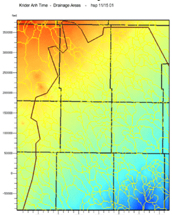
Chase Group (Krider Member) at Anhydrite Time
Gas Migration (Injection from SE)
 |
 |
 |
Projected Flow Paths Krider at Anhydrite Time |
Projected Drainage Cells Krider at Anhydrite Time |
Color shading indicates projected structure of Krider at Stone Corral Anhydrite Time (Permian) Preliminary Gas Migration Model for Krider Hugoton Field, SW Kansas
|
 |
 |
Projections made with IES PetroMod migration modeling software
http://www.ies.de/Products/producttxt.htm
|
|
|
e-mail : webadmin@kgs.ku.edu
Last updated May 2003
http://www.kgs.ku.edu/PRS/publication/2003/ofr2003-29/P3-03.html