Kansas Geological Survey, Open-file Report 2002-65
by
John H. Doveton
KGS Open File Report 2002-65
Exploration for productive Cherokee sandstones in south-east Kansas in the early part of the twentieth century marked a radical change in philosophy from traditional methods that had relied on structural mapping. Initial exploratory boreholes on structural highs were dry, while successful wells were found to have no logical link with structural features. The first production appeared to be located off structural highs in a north to north-west direction and this observation was temporarily adopted as an exploration key until negated by further drilling (Miner, 1987). Ultimately, Cadman (1927) concluded that the sandstone bodies originated mostly in narrow meandering stream channels and that the key to success was to follow the "golden lanes," so-called because of their rich production coupled with their great length and relatively narrow width. However, Bass (1936) concluded on the balance of the evidence that the more prominent shoestring sandstones were most likely to have originated as marine offshore bar sands. Although the role of tectonic structure was muted, explorationists such as Rich (1938) pointed out that structural draping features were quite common above Cherokee sandstones and speculated that this was caused by differential compaction of shales contrasted with sandstones. The structural draping of limestone and black shale markers over Cherokee sandstones has also been noted by more recent authors, such as Van Dyke (1976), Hulse (1978), and Boquet (1984). Rich (1923) observed that the shape of the upper surface of the sandstone body varied between convex, concave, or flat configurations, but the morphology was probably linked with the depositional origin of the sandstone. In urging explorationists to apply principles of sedimentation in their search for shoestring sands, Rich (1923) made one of the earliest endorsements of sedimentology as an oil exploration tool. Interestingly, Rich (1926) also anticipated the modern interpretation of many of these Cherokee sandstones by suggesting their origin as incised valleys that were silted up, although he suggested mild tectonic uplift as the mechanism for incision.
In more recent times, the relatively shallow depths of the Kansas Cherokee sandstones have ruled against expensive exploration technology in favor of the pragmatism of the seasoned explorationist with experience and a straight-edge ruler or the enterprising oil-witch. Once the initial productive well has been sited, the exploration strategy is commonly to establish the trend from geological interpretation of the borehole sandstone section and some careful mapping of sandstone isopachs and potential draping features. Poor choices in hole location are used as a corrective education to relocate the reservoir trend. In the 1960's dipmeters were run in several Cherokee fields in south-east Kansas as part of a drilling strategy whose aim was to optimize development well location. The dipmeter case-study described in this paper has its own historic interest as a chapter in oil exploration history, but the conclusions are still relevant to contemporary Cherokee sandstone studies, particularly in the context of the technological descendant of the dipmeter, the borehole electrical imaging tool.
The dipmeter was introduced as logging tool to measure dips and strikes of features on borehole walls in the 1930's (Allaud and Martin, 1977). Originally an SP device, the design concept moved to a multi-armed microresistivity tool, where the correlation of microresistivity traces across a borehole could be analyzed in terms of the orientation of planar features. The vertical resolution of the earlier tools was adequate for measurements of structural dip, but the recognition of sedimentary features, such as cross-bedding was only possible for large sets such as eolian dune features. The necessary trignometric calculations were extremely time consuming and the shift to computer processing must mark one of the earliest applications of computers to geology (e.g. Moran and others, 1962). As the tool design evolved over time, the number of arms and electrode buttons was increased, and log processing software became increasingly sophisticated. High resolution dipmeters could now routinely discriminate sedimentary bedding features (Nurmi, 1984). Finally, vertical resolution progressively improved to the point where detailed electrical images of the borehole wall could be generated (Ekstrom and others, 1986).
Although the measurements of the dipmeter tool are microresistivity profiles of the borehole wall, the results are commonly presented as vector plots of dip and strike of planar features. The vertical axis is matched with depth and the horizontal axis is scaled for dip magnitude. At incremental depths, "tadpoles" are marked where successful correlations of microresistivity segments were possible between the measurements at the arms. The correlation quality is shown by the symbol of the tadpole head. The direction of dip is shown by the orientation of the tadpole tail as related to a conventional compass circle. The "tadpole plot" can then be searched for clusters of vectors with systematic trend, which are marked by colors referred to a standard convention, and then interpreted as to their geological meaning. The color coding equates green with trends of constant dip and azimuth, red with increasing dip with depth but constant azimuth, and blue with decreasing dip with depth but constant azimuth. The interpretation of the meaning of the dip patterns is rooted in conventional geological theory of the structural geometry of subsurface units. Dip patterns can be variously attributed to tectonic dips, fault associations, compactional drapes and features internal to lithologies, such as cross-bedding.
In the 1960's, when dipmeters were run in the Cherokee Group of Kansas, the tool was a three-armed device and dip vectors were computed from microresistivity traces by batch runs on IBM mainframe computers. The resolution of the vectors was sufficient to measure tectonic structure and draping character, but often insufficient to resolve sedimentary bedding features. The ability to measure compactional draping over the Cherokee sandstone bodies was a major factor in the decision to run the dipmeter as part of the logging program. While green tadpole patterns of relatively constant dip and azimuth would reflect regional tectonic dip, red patterns of increasing dip with depth immediately above the sandstone body would discriminate draping of shales over the sandstone. Although the strike of these vectors would be diagnostic of the local orientation of the long axis of the sandstone, diametrically opposite interpretations of the direction from the borehole location to the thicker axis were possible, dictated by whether the top of the sandstone was convex- or concave-upwards. Two basic geological models were suggested to match these alternatives: an offshore-bar with a convex upper surface or a channel-fill sandstone with a concave top. If bedding structures could be identified by dips within the sandstone, then the models could be discriminated by an expectation of bedding at right-angles to the axis for the bar, and parallel to the axis for the channel (Campbell, 1968). The geological interpretation of dipmeter logs recorded in successive wells can be part of a navigation strategy in the location of development wells of a Cherokee sandstone field as outlined in the following case study.
In 1965-66, a Bartlesville Sandstone reservoir in Bourbon County, Kansas, was developed for oil production as the Bronson SE Field. Dipmeters were run in some of the wells (and dry holes) as part of the field development program and a good example is provided from Woodward #CH-4. (Fig. 1). The gamma ray log shows a section that is primarily shale with a development of the Bartlesville Sandstone towards the base. The shallow dips of the tadpole plot are characteristic of many Mid-continent stratigraphic sequences where regional structure is fairly subdued. It should be noted that structure that is obvious from the correlation of marker horizons may be subtle as a dip measurement: a dip of only one degree is equivalent to a change in elevation of over 92 feet in a mile. On the other hand, well spacing is often too broad to register localized features such as surface draping immediately above a sandstone, which can be measured by the dipmeter.
Figure 1--Gamma-ray and dipmeter tadpole logs from the Cherokee Group in C.R.A. Woodward #4 12-25S-21E, Bourbon County, Kansas. The Schmidt net plots of tadpole vectors have a perimeter of 15 degrees dip and are referenced to section subdivisions.
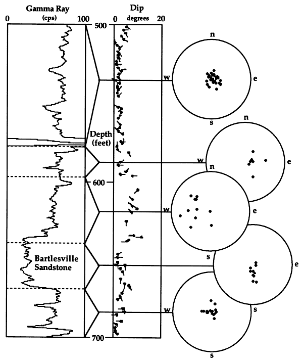
Schmidt nets are shown for subdivisions of the section. These polar projections are used commonly in the analysis of fold and fault geometry in structural geology, and so their use with dipmeter data is a useful extension of traditional geological methods. The highest shales show very minor dips with no discernible preferred orientation, that grade downward to a zone with small dips in an eastern orientation. These sets may match local dip associated with the broad drape of overlying limestones and other markers that have been observed by workers over many of the Kansas Cherokee fields. As already discussed, this style of drape can often be mapped by correlation between wells, but its magnitude is matched by very small dips.
In the zone immediately above the Bartlesville sandstone, there is a marked increase in dip, with a general western orientation and probably represents localized drape of the shale immediately over the upper surface of the sandstone. The data suggest that the long-axis of the sandstone is oriented north-south, and, if the upper surface of the sandstone is convex, that the central axis lies to the east of the well. The dips within the sandstone show an abrupt contrast, with dips strongly aligned to the south. If the dips discriminate the surfaces of crossbedding sets, then the cross-bedding direction is aligned with the axis of the sandstone body. This interpretation would suggest a current flow from north to south, and the depositional origin of the sandstone body as a channel. (The most likely alternatives of a marine bar or a strandline deposit would be expected to have cross-bed orientations at right-angles to the long axis.) The gamma ray profile of the sandstone is also consistent with a channel interpretation.
The illustrative well was the fourth in the development series, and a map of the field well locations (Fig. 2) graphically summarizes the progressive understanding of the location and orientation of the field. The wells are numbered in order of drilling and span a period between October 1, 1965 and July 18, 1966. Initially (wells 1 to 9), the Bartlesville Sandstone was interpreted to be a bar sand, but from then on the model was revised to a channel sandstone. As pointed out at the time, the change in model made no difference to the interpretation of the sandstone log-axis orientation, but did alter ideas on the direction of the sandstone axis (and thicker sandstone development) relative to the borehole location.
Figure 2--Drilling development of the Bronson SE Field, Bourbon County, Kansas from October 1965 to July 1966. The holes are numbered in order of drilling and bold numbers signify holes that were logged by dipmeter; hollow numbers reference holes that had no dipmeter logging. Each bar and arrow represents the strike and dip of draping in the shales immediately overlying the Bartlesville Sandstone as interpreted from dip vectors at the time of logging.
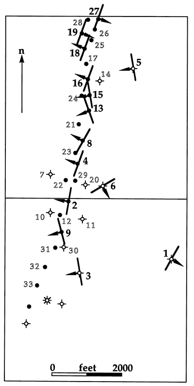
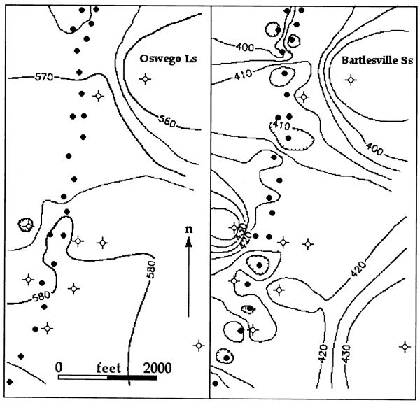
As can be seen on the map (Fig. 2), dipmeters were not run in all the boreholes, but only at times when the dip information was needed as an aid to interpretations drawn from core observations, correlation, and mapping. Overall, the siting of the development wells was very successful and quickly established a classic "golden lane" Cherokee pattern of a sandstone body with a relatively narrow width, but sustained linear trend. This characteristic makes it difficult to verify the structures of this field even after the fact, because the well control is so tightly constrained to the trend. However, some useful observations can be made from structure contour maps of the Oswego Limestone and the upper surface of the Bartlesville Sandstone (Fig. 3). The overlying Oswego Limestone shows a distinctive but gentle structural nose that reflects a broad compactional drape over the Bartlesville Sandstone. By contrast, the top of the Bartlesville Sandstone has a more complex configuration whose features represent real, but local, variability compounded by artifacts caused by poor well control. Interestingly, it does appear that the interpretation alternatives of convex versus concave upper surface may be simplistic and that the shape of the upper surface is variable along the length of this Bartlesville Sandstone body. In spite of this, the value of the dipmeter analysis in establishing sandstone strike is validated.
Figure 3--Structure maps of the Oswego Limestone (left) and the top of the Bartlesville Sandstone (right) in the Bronson SE field, Bourbon County, Kansas. Contours are in feet above sea level.
The old debates concerning the origin of individual Cherokee sandstones as deposits of either alluvial channels, deltaic distributaries, offshore bars or other environments has more recently been superceded by an incised paleovalley model rooted in sequence stratigraphy. Demonstrated convincingly by detailed geological studies and 3-D seismic in the older Morrow and Chester sandstones of western Kansas (e.g. Sonnenberg and others, 1990; Montgomery and Morrison, 1999), the incised valley paradigm has been documented to describe the Tonganoxie Sandstone in the younger Douglas Group of eastern Kansas (Archer and Feldman, 1995), and the Cherokee sandstones of south-eastern Kansas (Brenner, 1995; Walton, 1996). In this model, a vertical facies sequence of alluvial, estuarine, tidal, and marine deposits are commonly observed in incised valley sandstone cores. Tadpole plots from dipmeters run through the Morrow sandstones of western Kansas show unidirectional cross-bedding in the alluvial sandstone facies and bidirectional dips in the overlying tidal facies (Luchtel, 1999). Although the economics inhibit the use of modern dipmeters in the Cherokee sandstones of eastern Kansas, developments in sequence stratigraphy and results from dipmeters in sandstones elsewhere in Kansas and neighboring states can give fresh insights into the interpretation of old Cherokee sandstone data for both geological and commercial reasons.
Allaud, L., and Martin, M., 1977, Schlumberger, The History of a Technique: Wiley-Interscience, New York, 333 p.
Archer, A. W., and Feldman, H. R., 1995, Incised valleys and estuarine facies of the Douglas Group (Virgilian): Implications for similar Pennsylvanian sequences in the U.S. Mid-continent; in, Hyne, N.J. (ed.): Sequence Stratigraphy of the Mid-Continent: Tulsa Geological Society Special Publication No. 4, p. 119-140.
Bass, N. W., 1936, Origin of the shoestring sands of Greenwood and Butler counties, Kansas: Kansas Geol. Survey, Bull. 23, 126 p. [available online]
Boquet, D. J., 1984, Depositional environment, diagenesis, reservoir quality, and enhanced oil-recovery potential of a reservoir in the Skinner Sandstone (Desmoinesian), Crawford, Labette, and Neosho counties, Kansas: Unpubl. MS thesis, University of Kansas, 129 p.
Brenner, R. L., 1995, Sequences and cyclothems in upper portion of Cherokee Group (Middle Pennsylvanian, Desmoinesian), Mid-Continent, U.S.A.; in, Hyne, N.J. (ed.): Sequence Stratigraphy of the Mid-Continent: Tulsa Geological Society, Special Publication No. 4, p. 193-216.
Cadman, W. K., 1927, The Golden Lanes of Greenwood County: American Association of Petroleum Geologists, Bull., v. 11, p. 1151-1172.
Campbell, R. L., 1968, Stratigraphic applications of dipmeter data in the Mid-Continent: American Association of Petroleum Geologists, Bulletin, v. 52, no. 9, p. 1700-1719.
Doveton, J. H., 1994, Geologic Log Interpretation : SEPM, Short Course Notes, 169 p.
Ekstrom, M. P., Dahan, C. A., Chen, Min-Yi, Lloyd, P. M., and Rossi, D. J., 1986, Formation imaging with microelectrical scanning arrays: Society of Professional Well Log Analysts, 27th Logging Symposium, Paper BB, 12 p.
Hulse, W. J., 1978, A geologic study of the Sallyards field area, Greenwood County, Kansas: Unpubl. MS thesis, University of Kansas, 152 p.
Luchtel, K. L., 1999, Sequence stratigraphy and reservoir analysis of the upper Kearny Formation (Morrowan Series, Lower Pennsylvanian System) within three Kansas fields: Unpubl. MS thesis, University of Kansas, 149 p.
Miner, C., 1987, Discovery!: Cycles of Change in the Kansas Oil & Gas Industry 1860-1987: KIOGA, Wichita, 239 p.
Montgomery, S. L., and Morrison, E., 1999, South Eubank field, Haskell County, Kansas: A case of field redevelopment using subsurface mapping and 3-D seismic data: Am. Assoc. Petroleum Geologists Bull., v. 83, no. 3, p. 393-409.
Moran, J. H., Coufleau, M. A., Miller, G. K., and Timmons, J. P., 1962, Automatic computation of dipmeter logs digitally recorded on magnetic tapes: Journal of Petroleum Technology, v. XIV, no. 7, p. 771-782.
Nurmi, R. D., 1984, Geological evaluation of high resolution dipmeter data: SPWLA Twenty-fifth Annual Logging Symposium, Paper YY, 24 p.
Rich, J. L., 1923, Shoestring sands of eastern Kansas: American Association of Petroleum Geologists, Bulletin, v. 7, no. 2, p. 103-113.
Rich, J. L., 1926, Further observations on shoestring oil pools of eastern Kansas: American Association of Petroleum Geologists, Bulletin, v. 10, no. 6, p. 568-580.
Rich, J. L., 1938, Application of differential settling to tracing of lenticular sand bodies: American Association of Petroleum Geologists, Bulletin, v. 22, no. 7, p. 823-833.
Sonnenberg, S. A., Shannon, L. T., Rader, K., von Drehle, W. F., 1990, Regional structure and stratigraphy of the Morrowan Series, southeast Colorado and adjacent areas; in, Sonnenberg, S.A. (ed.), Morrow Sandstones of Southeast Colorado and Adjacent Areas: The Rocky Mountain Association of Geologists, Denver, p. 1-8.
Van Dyke, R. J., 1976, Geology and depositional environments of the reservoir sandstone, Kincaid Oil Field, Anderson County, Kansas: Unpubl. MS thesis, University of Kansas, 80 p.
Walton, A. W., 1996, Depositional framework and representative oil reservoirs of the Cherokee Group (Atokan-Desmoinesian, Middle Pennsylvanian), eastern Kansas; in, Johnson, K.S. (ed.), Deltaic reservoirs in the southern Midcontinent, 1993 Symposium: Oklahoma Geological Survey, Circular 98, p. 168-187.
Kansas Geological Survey, Energy Research
Placed on web Sept. 6, 2007; originally released in 2002
Comments to webadmin@kgs.ku.edu
The URL for this page is http://www.kgs.ku.edu/PRS/publication/2002/OFR02_65/index.html