
Chase Group from the near-surface Amoco No. 1 Hargrave core, Riley County, Kansas
by
Page C. Twiss
Department of Geology
Kansas State University
Abstract
The Amoco Production Company No. 1 Eldon Hargrave well in Riley County, Kansas, was cored continuously through the Lower Permian, Gearyan Stage Chase Group. This well is in the north-trending outcrop belt of the Lower Permian and supplies unique data unattainable at the surface. The Chase Group is 326 ft (99.4 m) thick and contains 31 rhythmic, transgressive-regressive units bounded by marine transgressive and climate-change surfaces. The depositional sequence progresses upward through 1) red mudstone/siltstone with paleosols, 2) green mudstone/siltstone, 3) yellowish-brown mudstone or calcilutite, 4) fossiliferous, micrograined limestone, 5) gypsum inclusions in micrograined calcilutite or dololutite, and 6) varicolored mudstone/siltstone. At several places in the core the depositional sequence has been interrupted by changes in sea level or climate.
Core study indicates the Chase Group is 54% carbonate rock. Dolomite is common in the upper parts of several carbonate units. Calcite and dolomite are minor constituents in the other rocks. Gypsum beds and inclusions and halite inclusions occur in the regressive parts of the cyclothems but are absent at the surface. Chert has replaced carbonate rock and gypsum in the lower, more marine units of the Group.
Introduction
Lower Permian rocks of the Gearyan Stage crop out in east-central Kansas along a north-trending belt about 50 mi (80 km) wide. Jewett (1941) described surface exposures of these rocks in Riley and Geary counties. Jewett (1933) also recognized the repetitive alternations of continental and marine mudstone and limestone, and Elias (1937) proposed an "ideal" depositional cycle that consists of a transgressive and a regressive hemicycle. Studies of exposures of individual formations generally have supported this concept. These sequences differ from the Pennsylvanian cyclothems of Kansas (Heckel, 1977) in that the Permian rocks lack coal, black shale, sandstone, and for the most part carbonate grainstone, and are distinguished by varicolored mudstone and siltstone, wackestone, laminated dolomicrite, and beds and inclusions of evaporite.
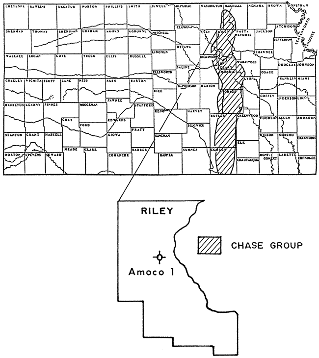
These rocks have been examined at the surface for more than 50 years without the benefit of subsurface samples. In 1975, Amoco drilled the No. 1 Eldon Hargrave well in Riley County (NE NE NE NE sec. 32, T. 7 S., R. 6 E., fig. 1) and cored the entire 782 ft (238.5 m) of Lower Permian rocks, thereby providing a complete subsurface record. For the first time a continuous subsurface record near the exposures of the Lower Permian rocks is available for detailed study.
Figure 1--Location of Chase Group outcrop in Kansas and Amoco Production Company No. 1 Eldon Hargrave borehole in Riley County (adapted from Zeller, 1968).
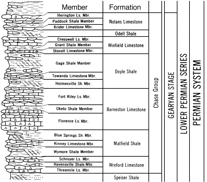
Sanderson and Verville (1988) of Amoco have described the fusulinids from the core, and other studies are progressing. Amoco released the core to the Kansas Geological Survey which has supported my detailed sedimentologic study. The Chase Group, the uppermost group of the Gearyan Stage (Wolfcampian equivalent), is 326 ft (99.4 m) thick and is the subject of this report (fig. 2). The Chase Group is the main reservoir interval of the huge Panhandle-Hugoton field of southwestern Kansas and the Oklahoma and Texas panhandles (see paper by Caldwell in this book).
Figure 2--Grapiuc column, members, and formanons of the Chase Group, Gearyan Stage, Lower Permian Series of Kansas (Zeller, 1968).
Stratigraphic units
The Amoco No. 1 Hargrave core includes the lower few feet of the Herington Limestone Member of the Nolans Limestone (uppermost Chase Group) and enters the underlying Council Grove Group at 326 ft (99.4 m). The upper 133 ft (40.6 m) is severely weathered, and only 74% of the cored interval was recovered. Below the weathered interval recovery was nearly continuous; the overall recovery for the Chase Group was 89%. The depths and thicknesses of the members and formations are listed in table 1.
The Chase Group consists of alternating limestone, dolostone, gypsum, and varicolored mudstone and siltstone that record several marine flooding events and subsequent regressions. The Chase Group is less marine than the underlying Council Grove Group.
Table 1--Stratigraphic units of the Lower Permian Chase Group penetrated by the Amoco No.1 Hargrave core.
| Formation | Member | Tops (ft) | Thickness (ft) |
|---|---|---|---|
| Nolans Limestone | Herington Limestone | 4.6 | |
| Paddock Shale | 9.1 | 10.87 | |
| Krider Limestone | 19.97 | 1.53 | |
| Odell Shale | 21.5 | 27.1 | |
| Winfield Limestone | Cresswell Limestone | 48.6 | 14.84 |
| Grant Shale | 63.44 | 7.06 | |
| Stovall Limestone | 70.5 | 1.72 | |
| Doyle Shale | Gage Shale | 72.22 | 44.98 |
| Towanda Limestone | 117.20 | 18.0 | |
| Holmesville Shale | 135.2 | 13.2 | |
| Barneston Limestone | Fort Riley Limestone | 148.4 | 34.74 |
| Oketo Shale | 183.1 | 11.36 | |
| Florence Limestone | 194.5 | 28.05 | |
| Matfield Shale | Blue Springs Shale | 222.5 | 38.48 |
| Kinney Limestone | 261.03 | 7.37 | |
| Wymore Shale | 268.4 | 17.84 | |
| Wreford Limestone | Schroyer Limestone | 286.24 | 19.66 |
| Havensville Shale | 305.9 | 12.03 | |
| Threemile Limestone | 317.93 | 8.1 | |
| Base of Wreford Limestone | 326.03 |
Methods
The entire core was examined and described using a binocular microscope. The data were plotted on a strip log at a scale of 1 inch = 10 ft. Colors were determined by comparison with the Rock-Color Chart and the Munsell Soil Color Charts. Selected surfaces of the core were treated with two concentrations of HCl, 6N and 1.5N, to distinguish dolomite from calcite and calcite from shale, mudstone, and siltstone, respectively. Rock surfaces were flooded with distilled water or methanol to reveal textures. Relative abundances and types of skeletal debris were recorded.
X-ray diffraction analysis was used to verify the binocular mineral identification. Each lithologic change was sampled from the outside surface of the core by drilling a 1/4-inch-diameter hole with a tungsten carbide bit and collecting the resulting rock powder. The powder was mounted in an aluminum holder and scanned at 1° 2-theta/minute from 60 or 40 to 1.5° with Cu K- alpha radiation. Areas of major peaks of quartz, feldspar, clay, calcite, dolomite, gypsum, anhydrite, and celestite were calculated to determine the relative abundance of each. Where diffraction peaks from individual minerals might interfere with major peaks of other minerals, secondary peaks were used (table 2). Peak areas of each mineral component were summed and the percentage of each calculated. A total of 390 samples were analyzed.
Table 2--Major diffraction peaks used to identify and determine relative abundance of each mineral in the Chase Group.
| Mineral | [hkl] | 2-theta (deg) | A.U. | Multiplier |
|---|---|---|---|---|
| Quartz | [100] | 20.8 | 4.26 | 5 |
| Feldspar | [002] or [040] | 28 + or - | 3.29-3.18 | 1 |
| Clay | [001] | 8.8, 12.4 | 10,7.14 | 1 |
| Calcite | [104] | 29.4 | 3.035 | 1 |
| Dolomite | [104] | 30.96 | 2.886 | 1 |
| Gypsum | [020] | 11.7 | 7.61 | 1 |
| Anhydrite | [002, 020] | 25.50 | 3.49 | 1 |
| Celestite | [211] | 30.04 | 2.972 | 1 |
After XRD analysis each sample was treated with 6N HCl and the percent of insoluble residue was determined. The percent of insoluble residue was used as a comparison and check of the XRD mineral identification of carbonates and non-carbonates.
Armed with the XRD and insoluble residue data, I reexamined the core with a binocular microscope and the results plotted at a scale of 1 inch = 1 ft. This detail reveals characteristics that are difficult or impossible to recognize in surface sections.
Lithologies
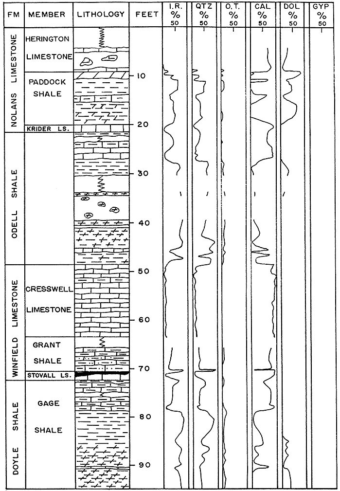
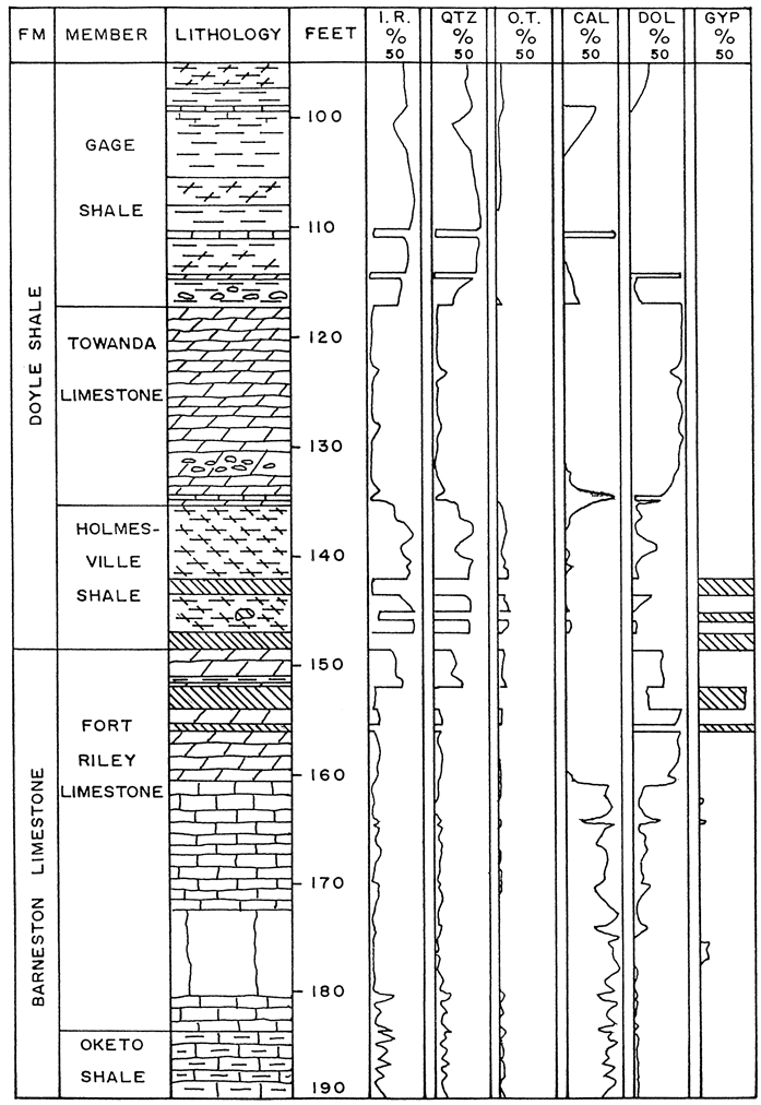
The lithology, insoluble residue, and mineral composition of units of the Chase Group are shown in fig. 3. The core emphasizes that far more carbonate rock occurs in the Chase Group than has been recognized in surface outcrops. Significant quantities of dolomite, gypsum, anhydrite, and halite occur in the subsurface, yet have not been recognized in exposures. Solid evidence for the replacement of evaporite minerals, skeletal debris, and carbonate rock by chert occurs in the subsurface and to a lesser degree at the surface. Comparison of the subsurface with the surface reveals that dissolution of carbonate rock and evaporites have enhanced porosity. Several paleosols have been identified in the core, many of which have been observed in outcrops.
Figure 3--Formations, members, lithology, and mineralogy of the Chase Group of the Amoco No. 1 Hargrave core, Riley County, Kansas. FM = formation; I.R. = insoluble residue; QTZ, = quartz; O.T.= other terrigenous minerals including alkali feldspar and plagioclase, illite, chlorite, and kaolinite; CAL = calcite; DOL = dolomite; and GYP = gypsum, anhydrite, and celestite.
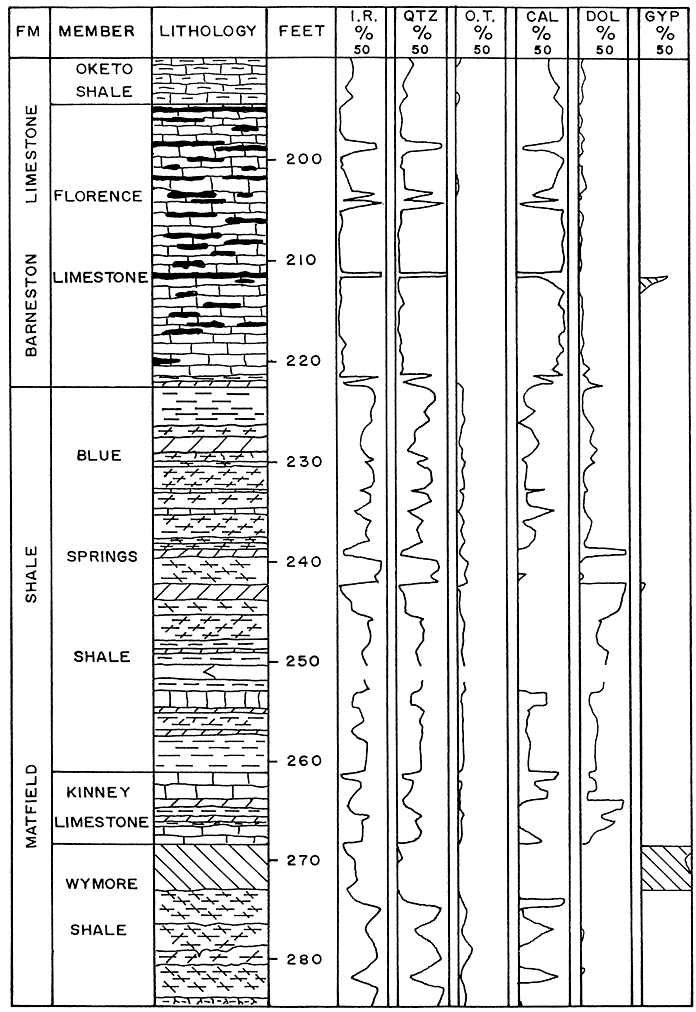
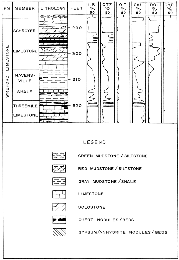
Carbonate rocks
Chase Group rocks that contain more than 50% carbonate minerals total 54%. Most of the limestone and dolostone are micrograined and are classed as carbonate mudstone or wackestone. Only two thin beds of grainstone occur, one at the base of the Towanda Limestone and the other at the top of the Schroyer Limestone. Many units classed as shale in outcrop are clayey wackestones or carbonate mudstones in core. These units contain up to 35% siliciclastic material.
Dolomite is common in the Chase Group of the Amoco core. Almost all of the Towanda Limestone (117.2-135.2 ft), the upper Fort Riley Limestone (148.3-160.7 ft), and Schroyer Limestone (287.5-194.9, 297.6-302.5 ft) are micrograined dolostone. Dolomite is prominent in the Herington Limestone, Paddock Shale, Odell Shale, Gage Shale, Holmesville Shale, Blue Springs Shale, and Kinney Limestone. Data on the mineralogy of surface exposures are lacking.
The dolostones are very pale yellow (5Y8/1) to light gray (2.5Y7/1) and unfossiliferous; only a few beds are slightly fossiliferous with fragments of crinoids, bryozoans, bivalves, ostracodes, and/or brachiopods. Many dolostones are laminated and burrowed. Some beds contain rhizoliths and evaporite inclusions. The limestones tend to be darker gray and more fossiliferous.
Evaporites
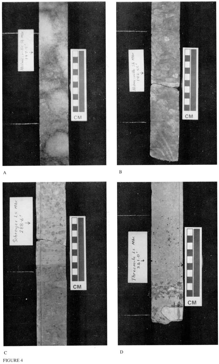
The Amoco No. 1 Hargrave core contains gypsum, anhydrite, and halite throughout, but evaporites are absent at surface exposures. Gypsum occurs as beds, as inclusions in limestone and dolostone, and as seams of satin spar in mudstone, siltstone, and carbonate rock. The uppermost gypsum is in the Holmesville Shale at 142.2-143.5 ft where it occurs in silty mudstone as nodules (originally anhydrite) that are bounded by seams of satin spar (fig. 4). A massive 2.4-ft (0.7-m)-thick gypsum bed containing relict nodules of anhydrite composes the lower part of the Holmesville Shale. Similarly a massive gypsum bed makes up the upper 4.9 ft (1.5 m) of the upper Wymore Shale (268.4-273.3 ft). Gypsum also is in the dolostone part of the upper Fort Riley Limestone, in the Schroyer Limestone as nodules and seams, and occurs as inclusions in the Threemile Limestone.
Figure 4--Bedded gypsum and gypsum inclusions in Chase Group, Amoco No. 1 Hargrave Core. [An Acrobat PDF file containg all three core figures is available.]
- Bedded gypsum in Holmesville Shale Member of Doyle Shale at 147.5 ft. White circular bodies may have been anhydrite originally.
- Subspherical gypsum nodules and associated bands of satin spar in dolomitic mudstone of Holmesville Shale Member at 142.55 fL
- Small spherical gypsum inclusions in upper, light-gray dololutite. Small inclusions occur in lower, medium-gray dololutite that also contains lensoid inclusions of satin spar adjacent to the base of scale. Note sharp boundary at about 3 cm. The lower dololutite also contains rectangular, micrograined clasts of dolomicrite. This slab is from the Schroyer Limestone Member of Wreford Limestone at 288.6 ft.
- Medium-gray, irregular gypsum inclusions in light-gray wackestone. White chert nodules are outlined in black. Sample is from the Threemile Limestone Member of Wreford Limestone at 321.0 ft.
Although halite was not recognized in the XRD analyses, the salty taste in some beds was traced to small (1-mm) inclusions in many thin horizons in the Fort Riley Limestone (172.2-173.2, 174.2-174.8 ft), Florence Limestone (203.6-203.8, 206.8-215.6, 222.0-222.5 ft), Blue Springs Shale (222.6-228, 242.6-243.6 ft), Kinney Limestone (264.3-266.2), Wymore Shale (280.3-285.6 ft), Schroyer Limestone (300.7-301.1 ft), and Threemile Limestone (321.1-321.3 ft; fig. 3). The halite is closely associated with dolostone, dolomitic limestone, and gypsum. Thin lenses of secondary celestite inclusions occur in the Fort Riley Limestone (156.0-156.3, 167.2167.4 ft) and the Schroyer Limestone (304.9-305.0 ft).
Many vugs and solution cavities are in the upper 130 ft (39.7 m) of the core. These seem to be the result of dissolution of carbonate rock and evaporite nodules and inclusions. Many vugs and cavities seen in outcrop are the result of similar dissolution.
Chert
The chert-bearing members of the Chase Group, the Florence Limestone, Schroyer Limestone, and Threemile Limestone, form the "backbone" of the Flint Hills physiographic province, a north-trending belt in east-central Kansas. Chert occurs in these same units in the Amoco core and contains evidence for its replacement origin. Chert has replaced gypsum or anhydrite nodules and carbonate rock (fig. 5).
The majority of the chert in the Hargrave core occurs in beds or discontinuous bands parallel to bedding in the Stovall Limestone, Florence Limestone, Schroyer Limestone, and Threemile Limestone. The chert contains the same textures and skeletal debris (but silicified) as the enclosing limestone. Many nodules have an irregular shape that suggests burrows that were filled with sediment and later silicified.
Silicified evaporite rosettes and nodules are in the Florence Limestone (198.6 ft), Schroyer Limestone (299 ft), and the Threemile Limestone (324.5 ft). Inclusions of gypsum and chert occur together in the Florence (210-213.2, 214.6-216.5 ft), Schroyer (291.5-294.4, 299-300 ft), and Threemile (321.2 ft).
Figure 5--Association of chert and gypsum in the Chase Group, Amoco No. 1 Hargrave Core. [An Acrobat PDF file containg all three core figures is available.]
- Partly silicified gypsum nodule in Schroyer Limestone Member of Wreford Limestone at 293.6 ft. Dark concentric band inside nodule is gypsum, whereas the lighter color is microquartz.
- White, nodular bodies are microquartz that have replaced original gypsum or anhydrite. Darker bodies are gypsum that are joined and surrounded by satin spar. Sample is dololutite in middle of Schroyer Limestone Member of Wreford Limestone at 299.0 ft.
- Chert rosette that was originally gypsum or anhydrite. Laminated, clayey wackestone of the Florence Limestone Member of Barneston Limestone at 198.6 ft.
- Irregular chert nodule (opposite arrow) surrounded by small irregular gypsum inclusions in calcilutite of Florence Limestone Member at 212.0 ft.

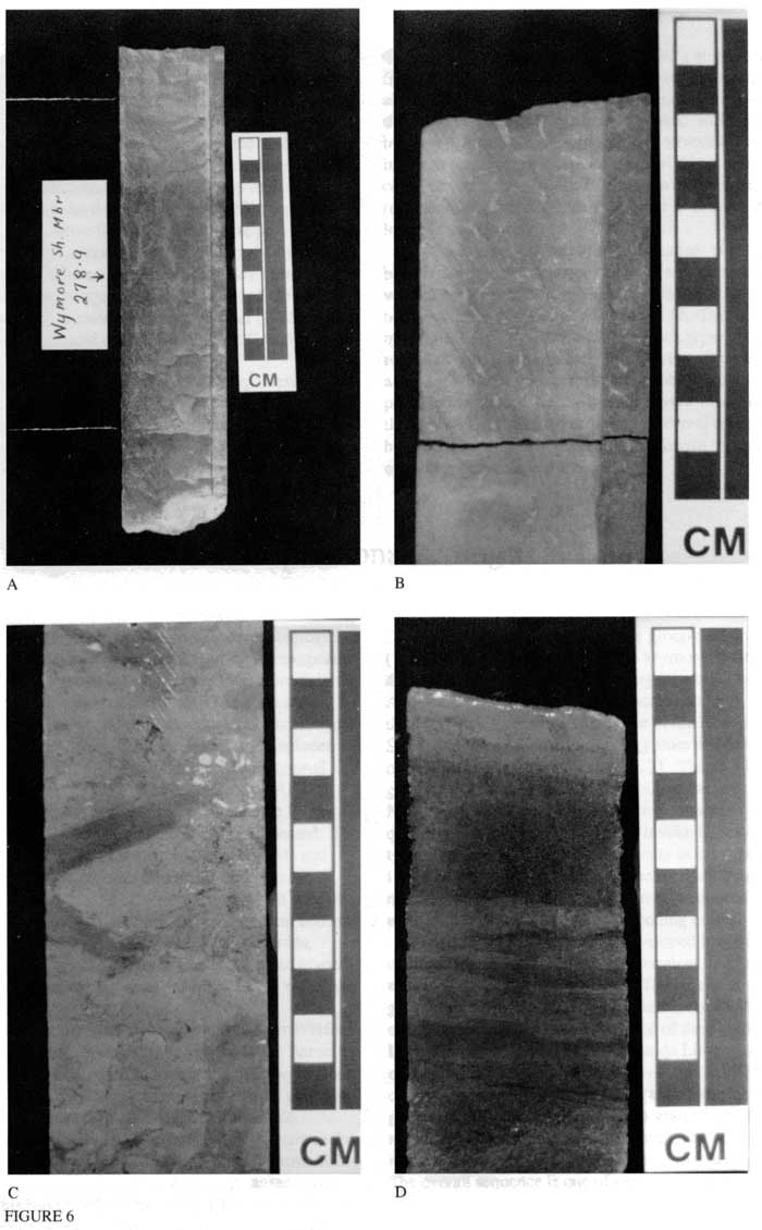
Figure 6--Paleosols, burrows, and grainstone in Chase Group, Amoco No. 1 Hargrave Core. [An Acrobat PDF file containg all three core figures is available.]
- Paleosol in Wymore Shale of Matfield Shale at 278.9 ft. Note the sharp boundary at 8 cm on scale in which reddish mudstone is truncated by greenish-gray mudstone. Root traces are greenish gray, vertical threads in the lower reddish mudstone.
- Paleosol in Blue Springs Shale Member of Matfield Shale at 231.4 ft. Root traces are light-colored, gleyed, irregular, and elongate inclusions in pale-red siltstone.
- Dark, elongated, and branched planolitid burrow in bioturbated, light-gray wackestone. Upper burrow terminates in a pocket of crinoidal debris at 8 cm on scale. "Rimrock" (prominent ledge in outcrop) at base of Fort Riley Limestone Member of Barneston Limestone at 179.8 ft.
- Dark, bedded, oolitic and coated-grain grainstone near base of the Towanda Limestone Member of Doyle Shale at 134 ft. Good intergranular and oomoldic porosity.
Contacts of lithologic units
Close core examination reveals many sharp lithologic contacts that suggest major changes in depositional environments. Flooding events are suggested by 1) sharp boundaries between mudstone/siltstone and overlying carbonate rock, 2) abrupt changes in diversity of fossils, 3) sharp boundaries between textures in carbonate rocks, and 4) abrupt changes between bioturbated and laminated rocks. Truncation at the upper surface of paleosols indicates sudden changes in a formerly stabilized terrigenous environment. Only a few transitional boundaries have been observed in the core.
Cyclicity
Mark Jewett (1933) recognized the repetitive alternations of continental and marine mudstone and limestone in the Lower Permian rocks of east-central Kansas. The eight to 10 cyclic units he recognized consist of, in ascending order: 1) basal varicolored red and green, non-fossiliferous shale, 2) a thin bed of limestone or gray or yellow, calcareous mudstone, 3) very fossiliferous, gray or yellow shale with brachiopods generally predominant, and 4) an upper series of massive, fossiliferous limestone beds.
Elias (1937) proposed an "ideal" depositional cycle for the Lower Permian that consists of a transgressive and a regressive hemicycle. He proposed seven phases which developed in specific depth ranges and produced distinct, invertebrate fossil assemblages. Phase 1, the red shale, is nonmarine, whereas phase 7, the fusulinid phase, was deposited at water depths of 160-180 ft (49-55 m) and recorded maximum marine transgression. This model was a refinement of Jewett's cycle.
Applying this model to the Lower Permian (Admire, Council Grove, and Chase Groups), Elias showed smooth, symmetrical, relative sea-level curves that seemed to document 20 gradual deepening and shallowing events. For the Chase Group he showed eight cycles with the maximum marine transgression represented by the lower Florence Limestone. The upper 200 ft of the Chase Group consisted of five cycles in which the marine transgressions were not as great, and the accumulation of terrestrial sediment was thicker, that is, an overall marine regression.
Chase Group cycles differ from the "ideal" Kansas cyclothem of Heckel (1977). The red and green mudstone and siltstone of the Chase Group represent the outside shale, but the deeper core shale which separates the thin, transgressive limestone from the upper regressive limestone in the Kansas-type cycles, is largely missing from the Chase Group. The thick Fort Riley Limestone Member records transgression at the base and slower regression in the thicker upper part. Heckel (1988) would term these abbreviated cycles of the Chase Group as minor cyclothems.
Busch (1988) applied the PAC hypothesis (Goodwin and Anderson, 1985) to two measured surface sections of the Wreford Limestone, Matfield Shale, and lower Florence Limestone Member of the Barneston Limestone in southern Riley County, Kansas. He described cyclic and rhythmic cyclothems for this study. Cyclic cyclothems correspond to Heckel's model and are fifth-order T-R (transgressive-regressive) units (Busch and others, 1985). Rhythmic cyclothems are sixth-order T-R units that contain limestone-mudstone couplets. Busch (1985) invoked "climate change surfaces" for terrestrial couplets in which paleosols or calcretes are overlain by more humid coals, lacustrine sediments, or alluvium. Therefore, he recognized eight correlative sixth-order T-R units in the lower Chase Group.
My approach has been to document the sharp boundaries between depositional units and to establish vertical sequences. Where Busch (1988) described eight transgressive surfaces, I have included 12. This difference may reflect the 17-mi (27.4-km) distance separating the two study areas. Additionally, the nearly complete record available with the core permits closer observation than is possible in outcrop. Because of the severe weathering of the upper 133 ft (40.6 m) of the core, several contacts may have been missed. The paleosols that Busch recognized in outcrop are present in the core.
Depositional setting
Although the paleobiologic framework is incomplete, by combining lithologic and fragmentary paleobiologic characteristics, four environmental regimes are suggested and sea-level curves developed for the Chase Group in the Amoco No. 1 Hargrave core (fig. 7). The nonmarine facies contains paleosols, plant remains, root traces, and a preponderance of quartz, feldspar, and clay; it includes supratidal and terrestrial environments. The marginal marine facies consists of bivalves, ostracodes, AND inarticulate brachiopods; forms that can tolerate fluctuations in salinity. The sediment tends to be laminated. The transitional marine environment includes crinoids and several brachiopod genera. This environment is less restricted than the marginal marine environment with its shifting salinities. The open-marine environment contains the highest diversity of fossils, including fusulinids, several brachiopod genera, fenestrate and ramose bryozoans, and crinoids; the region is generally below wavebase and the sediment is bioturbated.
Figure 7--Relative sea-level curve for the Chase group, as deduced from examination of the Amoco No. 1 Hargrave Core in northern Riley County, Kansas.
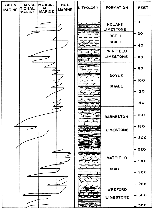
The most marine sequences are in the lower Wreford Limestone, all but the upper 15 ft (4.6 m) of the Barneston Limestone, the Winfield Limestone, and the lower Nolans Limestone. The nonmarine or marginal marine units are the Matfield Shale, Doyle Shale, and Odell Shale.
Elias (1937) recognized a thick bed of gypsum in the Easly Creek Shale of the underlying Council Grove Group which has been mined near Blue Rapids, Kansas, since 1871. This bed is in the Amoco No. 1 Hargrave core and is also present in the subsurface some 20 mi (32 km) to the southwest (Alex Kotyantz, 1991, personal communication). In the Amoco core the Chase group contains 5 ft (1.5 m) of gypsum at the top of the Wymore Shale, directly in contact with the overlying Kinney Limestone. Another 2.4 ft (0.7 m) of gypsum occurs abruptly above the Fort Riley Limestone at the base of the Holmesville Shale. Nodules and inclusions of gypsum and halite are in other units of the Chase Group (fig. 3). The abundance of gypsum and halite in the Chase Group of east-central Kansas requires a semi-arid to and environment. Yet, the quantity of evaporites is too low to invoke the model of a typical sabkha. The moderate diversity of invertebrate fossils in the transgressive carbonate rock units suggest a marine environment. The sharp contacts between rock units imply rhythmic and abrupt flooding events.
The Chase Group probably developed in a shallow, marginal marine and tidal flat environment that had an extremely low depositional slope. The lack of coarse-grained siliciclastics and grainstones, except for thin beds of coated-grain grainstones at the top of the Schroyer Limestone and the base of the Towanda Limestone, exclude widespread high-energy environments. The climate was semi-arid to and and warm. Development of paleosols and accumulations of fine-grained terrestrial muds and silts were interrupted several times by sudden marine transgressions and subsequent gradual regressions. The overall sequence is one of general carbonate regression.
Summary
The Chase Group core from the Amoco No. 1 Hargrave stratigraphic test provides unique subsurface data for comparison with nearby surface data that have been collected for more than half a century. The nearly complete and continuous record of the subsurface provides heretofore unavailable information about marine transgressions, the significance of evaporites, and the origin of chert. The core serves as a reference section that links the adjacent surface to the subsurface.
The Chase Group contains 31 rhythmic punctuations (fig. 7) that record transgressive and regressive carbonate-siliciclastic sequences. The vertical sequence progresses upward through 1) red mudstone/siltstone with some paleosols, 2) green mudstone/siltstone, 3) yellowish-brown mudstone or calcilutite, 4) fossiliferous, micrograined limestone, 5) gypsum inclusions in micrograined calcilutite or dololutite, and 6) varicolored mudstone/siltstone. The sequence can be terminated at any point by flooding events or climatic changes.
More than half of the Chase Group is carbonate rock and most other rocks have high calcite and dolomite contents. The rocks are nearly all fine grained. Beds and nodules of gypsum, anhydrite, and inclusions of halite are common. Several paleosols have developed in the terrestrial mudstones and siltstones. Chert has replaced limestone, dolostone, and evaporite.
References
Busch, R. M., 1985, Stratigraphic analysis of Pennsylvanian rocks using a hierarchy of transgressive-regressive units: Ph.D. dissertation, University of Pittsburg, 427 p.
Busch, R. M., 1988, Minor T-R units in the Lower Permian Chase Group, northeast Kansas: Geological Society of America, Centennial Field Guide, South-central Section, p. 17-24
Busch, R. M., West, R. R., Barrett, F. J., and Barrett, T. R., 1985, Cyclothems versus a hierarchy of transgressive-regressive units; in, Recent Interpretations of Late Paleozoic Cyclothems, W. L. Watney, R. L. Kaesler, and K. D. Newell, eds.: Conference Symposium, Society of Economic Paleontologists and Mineralogists, Mid-Continent Section, p. 141-153
Elias, M. K., 1937, Depth of deposition of the Big Blue (late Paleozoic) sediments in Kansas: Geological Society of America, Bulletin, v. 48, p. 403-432
Goodwin, P. W., and Anderson, E. J., 1985, Punctuated aggradational cycles; a general hypothesis of episodic stratigraphic accumulation: Journal of Geology, v. 93, p. 515-533
Heckel, P. H., 1977, Origin of phosphatic black shale facies in Pennsylvanian cyclothems of midcontinent of North America: American Assoc. of Petroleum Geologists, Bulletin, v. 61, p. 1,045-1,068
Heckel, P. H., 1988, Classic "Kansas" cyclothems: Geological Society of America, Centennial Field Guide, South-central Section, p. 43-56
Jewett, J. M., 1933, Evidence of cyclic sedimentation in Kansas during the Permian Period: Kansas Academy of Science Transactions, v. 36, p. 137-140
Jewett, J. M., 1941, The geology of Riley and Geary counties, Kansas: Kansas Geological Survey, Bulletin 39, 164 p. [available online]
O'Connor, H. G., Zeller, D. E., Bayne, C. K., Jewett, J. M., and Swineford, A., 1968, Permian System; in, The Stratigraphic Succession in Kansas, D. E. Zeller, ed.: Kansas Geological Survey, Bulletin 189, p. 43-53 [available online]
Sanderson, G. A., and Verville, G. J., 1988, Permian fusulinids from the Amoco Production Company No. 1 Eldon Hargrave core, Riley County, Kansas; in, Permian Rocks of the Midcontinent, W. A. Morgan and J. A. Babcock, eds.: Midcontinent Society of Economic Paleontologists and Mineralogists, Special Publication No. 1, p. 205-212
Zeller, D. E., 1968, The stratigraphic succession in Kansas: Kansas Geological Survey, Bulletin 189, 81 p. [available online]