
Stratigraphy and depositional setting of oolitic reservoir analogs in the Lower Missourian (Pennsylvanian) Bethany Falls and Mound Valley limestones, southeastern Kansas, U.S.A.
by
John A. French
Kansas Geological Survey and
The Department of Geology, The University of Kansas
Abstract
Significant quantities of unswept mobile oil are present in Pennsylvanian reservoirs in the midcontinent region of the United States. To effectively increase recovery of this oil, the depositional and diagenetic controls on reservoir heterogeneity must be understood. To accomplish this, reservoir-quality carbonate units are being studied at the surface and in the adjacent shallow subsurface as analogs to the equivalent producing zones.
At and near the outcrop belt in southeastern Kansas, the lower Missourian Bethany Falls and Mound Valley limestones both contain oolitic grainstones similar to the lithofacies that produce from these units farther west. Depositional sequence analysis of these units suggests that 1) at least two cycles of relative sea-level change controlled the vertical distribution of porosity zones within this succession, and 2) the character and distribution of reservoir-scale grainstone buildups within these two depositional sequences were also influenced by pre-existing depositional topography.
Introduction and goals of study
Pennsylvanian rocks of the midcontinent region of the United States may ultimately produce nearly 9 billion barrels of oil (Rascoe and Adler, 1983). In Kansas, nearly 500 million barrels of unswept mobile oil remain in existing Pennsylvanian reservoirs (BPO/Toris data base). Most of these reservoirs occur in relatively thin and discontinuous phylloid-algal, chaetetid, and crinoid-bryozoan-dominated carbonate buildups, oolitic and bioclastic grainstones, and quartz-rich sandstones (Watney et al., 1989). The occurrence of individual carbonate reservoirs is related to both favorable depositional setting (e.g., grainstone shoals) as well as early diagenesis associated with subaerial exposure, where dissolution of carbonate grains by meteoric waters is a common mechanism of porosity and permeability development.
Porosity and permeability development in these Pennsylvanian carbonate reservoirs is commonly heterogeneous due to the complex interplay among depositional, diagenetic, and tectonic processes that influenced reservoir evolution. Both vertical and lateral heterogeneity can be significant; for example, the 80-well Cahoj field in Rawlins County, Kansas, is compartmentalized into elements that range from one to 10 wells (Watney and Stephens, in press). Such reservoir inhomogeneities must be understood by development geologists in order to maximize recovery from these fields through application of secondary and tertiary recovery methods.
In order to better understand the vagaries of porosity and permeability trends within carbonate reservoirs in the lower Missourian Lansing and Kansas City Groups in Kansas, near-surface analogs of individual zones are being studied intensively, using outcrops, shallow cores, and an extensive wireline-log data base. The advantage of such near-surface studies is that the actual reservoirs generally occur at depths of several thousands of feet in the central and western part of the state and typically lack lithologic information of the type provided by outcrops and closely spaced cores. Analog studies such as these will promote a detailed understanding of the controls on reservoir-type development in strata that are demonstratively equivalent to actual producing zones.
The purposes of this paper are to describe and interpret the occurrence of porous carbonate lithofacies within the Bethany Falls and Mound Valley limestones in Bourbon and Allen counties, southeastern Kansas. These reservoir-type units are lithologically similar and genetically equivalent to the oil- and gas-producing K-zone that occurs in the subsurface in central and western Kansas. Information about processes such as relative sea-level change and diagenesis, which profoundly affect the distribution of porous and permeable lithofacies in this unit, is potentially transferable to the equivalent producing zones.
Cores from an area in west-central Bourbon County will be on display at this workshop. The selected cores are from an area where well-developed porosity zones in both the Bethany Falls and Mound Valley limestones thin and pinch out relatively abruptly. This region will be discussed in more detail later in this paper.
Stratigraphic interval and area of study
The stratigraphic interval considered in this paper includes the lower Missourian Swope and Mound Valley limestones (fig. 1). The total area considered in this report is an approximately 2,400 mi2 (6,200 km2) portion of southeastern Kansas that includes the lower Missourian outcrop belt and adjacent areas to the west where these units occur in the shallow subsurface at less than 200 ft (60 m) (fig. 2). A smaller 200 mi2 (560 km2) area (fig. 2) will be discussed in detail.
Figure 1--Schematic section of a portion of the Pennsylvanian System in Kansas showing the interval discussed in this paper; modified from Heckel (1977).
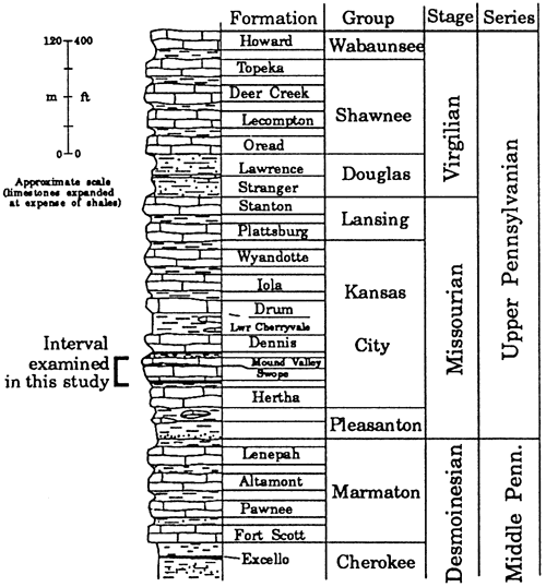
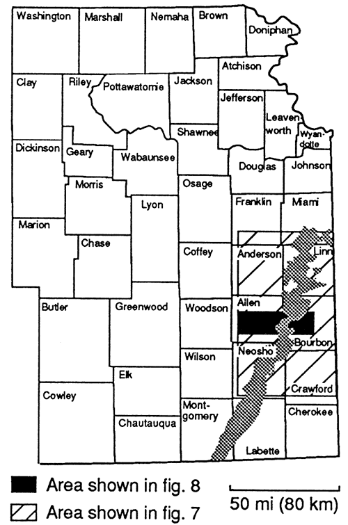
Figure 2--Map of Kansas showing locations of detailed maps of study area.
Stratigraphy and occurrence of reservoir-type units
Stratigraphic cyclicity in the lower Missourian
Laterally continuous, cyclically alternating strata typify the Pennsylvanian System in many areas of the world, and are especially well-developed in the midcontinent of North America (e.g., Weller, 1930; Moore, 1931; Heckel, 1977, 1984). Missourian cyclothems of Kansas typically consist of (in ascending order) a thin transgressive limestone, a non-sandy phosphatic black shale, a relatively thick regressive limestone, and a generally mud-dominated siliciclastic unit of variable thickness that may contain coals, sandstones, or red beds (Heckel, 1984) (fig. 3). Blocky mudstones and seat earths, interpreted as paleosols that formed during periods of prolonged subaerial exposure, commonly occur just above the regressive limestone or within the overlying siliciclastic unit. The upper portion of many of the regressive limestones also shows evidence of subaerial exposure in the form of laminated crusts or microkarstic features. Individual lower Missourian cyclothems typically range from less than 20 ft (about 6 m) to over 80 ft (about 25 m) in thickness, with some variation within individual cyclothems related to factors such as shelf position, siliciclastic content, and local carbonate buildups.
Figure 3--Generalized model of deposition of midcontinent cyclothems; modified from Heckel (1977, 1984).
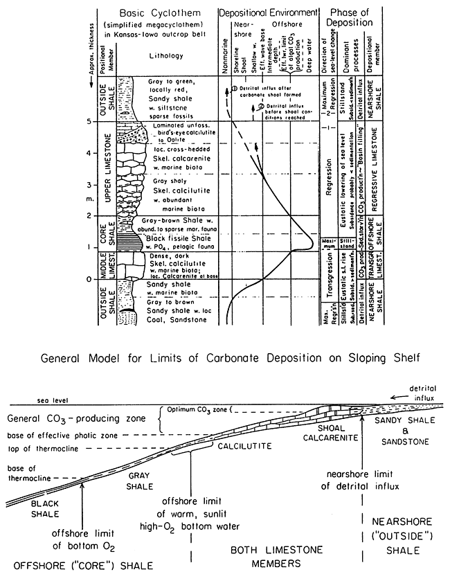
The exact mechanisms that controlled the development of these cyclothems have been vigorously debated since cyclicity in Pennsylvanian strata was first described in the late 1920's. Key features of these cyclothems that bear on their origin include 1) the great lateral persistence of individual cyclothems and their component members, such as black shales, with some being physically correlatable from westernmost Missouri to southeastern Colorado, a distance of more than 400 mi (almost 650 km); 2) the presence in individual cycles of lithofacies such as the laterally continuous phosphatic black shales that may represent water depths on the order of 650 ft (200 m) (Heckel, 1977), and paleosols, which formed during subaerial exposure; 3) estimates of cycle periods that are on the order of 120 ka to 400 ka for major cycles (see Heckel 1990, p. 44). These factors, coupled with the strong evidence for major continental glaciations during the Upper Pennsylvanian (Crowell, 1978; Veevers and Powell, 1987), suggest strongly that Missourian cyclothems of the type being investigated in this study are the product of glacial-eustatic fluctuations with amplitudes possibly in the range of 200 ft to 650 ft (60-200 m). Climate changes linked to these episodes of glaciation probably affected the nature of individual cyclothems as well. Rates of tectonic movement were almost certainly too low to have caused cyclic sedimentation during the Pennsylvanian (see Heckel, 1990), but may have been important in terms of longer-term thickness trends and facies patterns. More localized processes such as stream avulsion and the development of carbonate buildups affected individual cycles as well, but did not control the overall nature of cyclic sedimentation (Heckel, 1990).
Cyclothems as depositional sequences
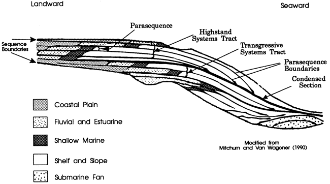
The concept of the "depositional sequence," used in this study, has become important in stratigraphic analysis in the last 15 years. A depositional sequence is defined as a relatively conformable succession of genetically related strata bounded by unconformities or their correlative conformities (Mitchum et al., 1977). Many of the midcontinent cyclothems were delineated on the basis of disconformities, including subaerial exposure surfaces, making them some of the first defined genetic stratigraphic units. Therefore, the cyclothems being considered in this report are excellent candidates for sequence-stratigraphic analysis, in which individual depositional sequences are analyzed in terms of a cycle of rise and fall of base-level. Important components of a given depositional sequence are termed systems tracts, which are contemporaneous depositional systems (Brown and Fisher, 1977) that are interpreted to have developed during a specific phase of a eustatic cycle (Mitchum and Van Wagoner, 1990). Systems tracts contain one or more parasequences, which are units that formed in response to a relatively abrupt water deepening. Recognition of specific systems tracts is commonly based on vertical stacking patterns of parasequences. For example, the transgressive systems tract might generally consists of a set of carbonate and/or siliciclastic parasequences that step progressively landward in vertical sequence (fig. 4). One elegant aspect of this approach to stratigraphic analysis is that even though specific lithofacies may change laterally within a given unit (as is commonly the case in the Missourian cycles), the trends in water depth represented by the strata in a given portion of a cyclothem (i.e. a systems tract) should tend to remain similar. This allows for the recognition of individual depositional sequences that may have developed in different settings (e.g., siliciclastic- vs. carbonate-dominated) and, perhaps more importantly, permits the prediction of lithofacies patterns and stratal geometries in equivalent depositional sequences, even in relatively distal areas where data are scarce.
Figure 4--Diagram of depositional sequence showing parasequences and systems tracts. Relative position of facies belts within sets of parasequences (e.g., shoreline facies stepping landward or basinward) and the vertical position of units within a sequence are key criteria used to define systems tracts (Mitchum and Van Wagoner, 1990).
Description and depositional sequence analysis of the study interval
The Bethany Falls and Mound Valley limestones, which contain the reservoir-type lithofacies being considered in this report, are interpreted to be the highstand systems tracts of distinct depositional sequences, herein termed the Swope and Mound Valley sequences (fig. 5). In the study area, the Swope sequence ranges in thickness from 31 ft to 44 ft (9.5-13.4 m) and in ascending order consists of:
1) the marine portion of the Elm Branch Shale, and the Middle Creek Limestone. The Elm Branch Shale overlies a subaerial exposure surface that occurs at the top of the Hertha Limestone. In places the basal part of the Elm Branch is an unfossiliferous, blocky mudstone with some coaly interbeds that are considered to be a paleosol. Overlying the inferred paleosol is a gray to dark-gray shale that contains scattered marine fossils such as brachiopods. This portion of the unit is interpreted to represent the initial marine flooding of a subaerial exposure surface on the underlying Hertha sequence.
The Middle Creek Limestone consists mainly of dark gray-brown lime wackestone that contains abundant marine fossils such as brachiopods, bryozoans, foraminifera, and phylloid algae. There is little evidence of early marine cementation in this unit (also see Heckel, 1983). The Middle Creek Limestone is interpreted to represent deepening marine water, reflecting a continuation of the Swope transgression. Together the marine portion of the Elm Branch Shale and the Middle Creek Limestone comprise the transgressive systems tract of the Swope depositional sequence.
2) the Hushpuckney Shale, which for the most part is a phosphatic, organic-rich, radioactive black shale. It is a condensed section that is interpreted to represent the maximum flooding of the midcontinent basin during "Swope time";
3) the Bethany Falls Limestone, which consists of two basic lithofacies. The lower portion consists mainly of non-porous bioclast wackestone, with fossils such as echinoderms, brachiopods, bryozoans, and phylloid algae constituting the bulk of the biota (fig. 6a). The upper portion is variably developed, and consists of generally porous, crossbedded, ooid-bioclast grainstone and well-washed packstone (figs. 6b and 6c). The upper surface of the unit commonly shows evidence of subaerial exposure in southeastern Kansas, such as rhizoliths, dissolution features, and laminated crusts. In the study area this surface is overlain in at least two cores by a mudstone unit (see below) that is interpreted to be a paleosol, at least in its lower part.
The Bethany Falls Limestone is interpreted to be a regressive deposit that represents shallowing marine water and eventual subaerial exposure. This interpretation is based on the general upward transition from diversely fossiliferous wackestones to oolitic grainstones and packstones. This unit is considered to be the highstand systems tract of the Swope sequence, reflecting progressive shallowing and ultimately subaerial exposure as sediments built up and relative sea level fell;
4) the Ladore Shale, which in this area is a greenish, unfossiliferous, blocky mudstone that exhibits features such as slickensides and root tubules. Such attributes suggest that the Ladore is a paleosol that marks the top of the Swope sequence.
Figure 5--Representative gamma ray-neutron log and stratigraphic column of study interval in west-central Bourbon County, Kansas. The grainstones and packstones of the Bethany Falls and Mound Valley limestones are the focus of this paper. Inferred depositional sequences and systems tracts are also shown.
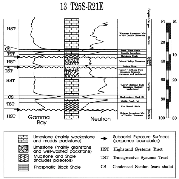
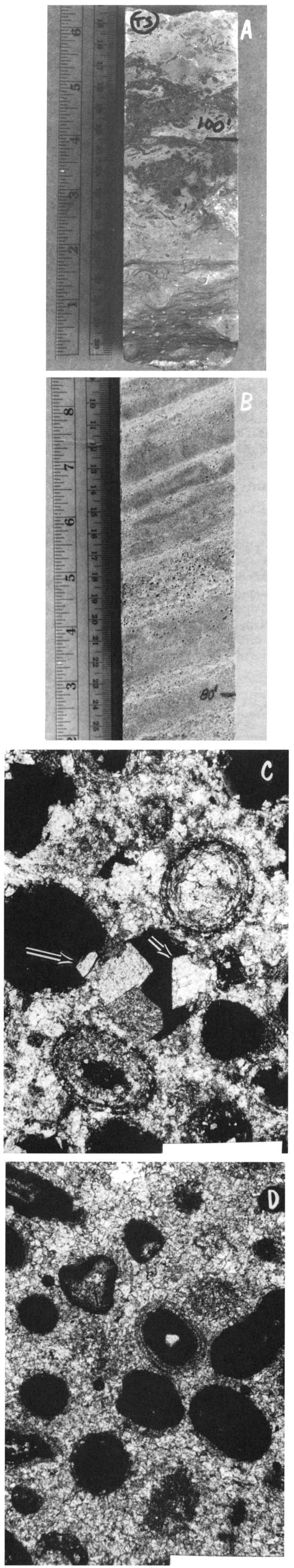
Figure 6--A) Argillaceous brachiopod-bryozoan-econoderm whole-fossil, wackestone typical of the lower Bethany Falls Limestone. The abundance of lime mud and a diverse and abundant biota suggest deposition in relatively deep, nomrmal-marine water. KGS Woodward #3, 99 ft, 10 inches, to 100 ft, 4 inches. B) Crossbedded ooid-bioclast grainstone representative of the upper Bethany Falls Limestone in the study area. Cross-sets over 3 ft (1 m) thick are common and contain beds and laminae of variable grain size and composition, sorting, and porosity development. Bar = 1 mm. KGS Woodward #3, 79 ft, 6 inches, to 80 ft, 1 inch. C) Oomoldic porosity (dark areas) within the upper Bethany Falls Limestone. Individual pores average between 0.5 and 1 mm in diameter and are commonly partially to totally occluded by saddle dolomite (arrows). KGS Woodward #3, 73.4 ft. D) Oomoldic and fossilmoldic porosity within the Mound Valley limestone. Pores in this unit average between 0.25 and 0.5 mm in diameter and have not been observed to have been affected by saddle dolomite precipitation. Bar = 1 mm. KGS Woodward #3, 64.5 ft.
The Mound Valley sequence is considerably thinner and less well developed than the Swope sequence. It ranges up to about 10 ft (3 m) in thickness, but is absent in many places. It directly overlies either the Ladore paleosol or the uppermost Swope carbonate unit. Where most completely developed, the Mound Valley sequence consists of three basic lithofacies types (in ascending order): 1) a basal relatively fine-grained, low-porosity peloid-bioclast packstone; 2) an upper, variably porous, bioclast-ooid grainstone and well-washed packstone (fig. 6d); 3) a gray-green, unfossiliferous blocky mudstone that displays slickensides, root traces, and in places contains calcareous lumps that resemble caliche nodules. This unit is interpreted to be a paleosol. Lithostratigraphically, it is part of the overlying Galesburg Shale, a unit that above the paleosol is the transgressive systems tract of the overlying Dennis sequence. Where the Mound Valley is absent, the lower Galesburg paleosol lies on the upper Bethany Falls Limestone; in such cases it is unclear as to whether the Ladore and Galesburg paleosols are amalgamated, because neither paleosol is always present.
Most of the Mound Valley should probably be considered as a highstand systems tract deposit. The lower peloidal portion may represent the transgressive deposits of the encroaching Mound Valley sea, as the relatively fine grain size and severely micritized nature of the grains may reflect slightly greater water depths during deposition of that part of the sequence.
In an hierarchical sense, the Mound Valley sequence represents a much smaller-scale relative sea-level event than does the Swope sequence. Whereas the Mound Valley is restricted to more basinal portions of the midcontinent basin, the Swope sequence can be traced onto and across the central Kansas uplift and to the limit of the Missourian outcrop belt in Iowa (Heckel, 1986).
Controls on the distribution of reservoir-type lithofacies
In the study area, both the Swope and Mound Valley sequences contain porous oolitic zones in their upper parts (figs. 5, 6b, c, d) that are similar to lithofacies that comprise many of the hydrocarbon reservoirs that occur in the equivalent K-zone in central and western Kansas (Watney, 1984). The distribution and possible origin of these reservoir-like lithofacies in the study area can be illustrated by a set of maps and cross sections (figs. 7-12).
Figure 7--Isopach map of interval from base Nuyaka Creek Shale to top Pleasanton (two cycles below Bethany Falls). Stippled pattern shows areas of >25 ft (7.6 m) Bethany Falls Limestone, which corresponds to oolitic-grainstone accumulations. Also shown is approximate location of detailed core transect at edge of one of the buildups (fig. 12).
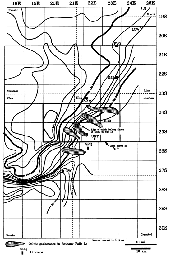
Figure 8--Detailed map of east-central Allen County and west-central Bourbon County, Kansas, showing thickness of interval from base Nuyaka Creek Shale to top Pleasanton Shale. Cross section locations are shown.
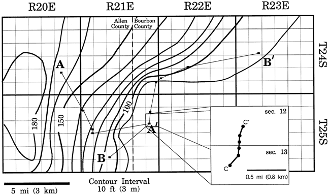
Figure 9--Northwest-southeast cross section showing thinning of Pleasanton Shale and occurrence of multiple Swope and Mound Valley oolitic lithofacies. Decompaction of the Pleasanton interval would accentuate vertical separation of oolites at west end of section (marked by a "?"), making it more apparent that they are separate, perhaps being basinward-stepping parasequences. [A larger Acrobat PDF version of this figure is available.]
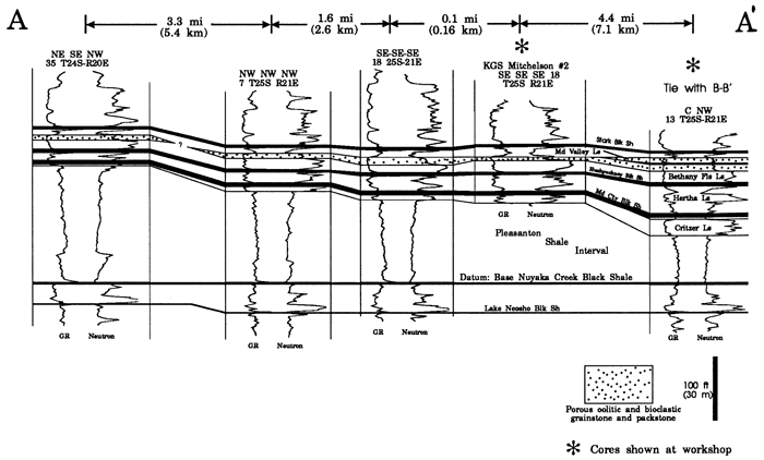
The lowermost carbonate-dominated Missourian sequences (the Hertha, Swope, and Dennis) overlie the Pleasanton Shale (fig. 1), which is an essentially homogeneous gray-green shale. The Pleasanton Shale attains a thickness of over 180 ft (55 m) about 15-25 mi (24-40 km) west of the outcrop belt and thins to less than 90 ft (27 m) along the outcrop of the Swope and Mound Valley sequences (figs. 7-9). Oolitic grainstones within these two depositional sequences tend to be thickest and best developed along this Pleasanton slope, presumably in response to higher-energy conditions that prevailed there. In addition, detailed mapping of the Bethany Falls Limestone portion of the Swope sequence has revealed a set of elongate, west-northwest to east-southeast-trending isopach thicks that reflect occurrences of the oolitic grainstones and packstones that typify the upper Swope. These areas of thick Bethany Falls Limestone range from about 1 to 3 mi (1.6-4.8 km) in width and some are at least 10 mi (16 km) long (fig. 7). These oolitic lenses that trend normal to an underlying depositional slope resemble the tidally influenced oolitic sand bars that occur on the modem Great Bahama Bank (Ball, 1967), although the individual modem sand belts are narrower. This may be due to a coalescence of the ancient bars through time, or may reflect the lack of closely spaced control needed to resolve smaller-scale oolitic buildups that may be present.
Some of the best-developed oolitic bars occur in association with a slight embayment in the Pleasanton slope (figs. 7 and 8). Such an embayment could have focused tidal currents, resulting in the observed grainstone bars. This embayment is also evident on isopach maps of the Nuyaka Creek to Hushpuckney interval and would be even more prominent on maps of the decompacted interval.
The best development of porous oolitic carbonate in the Swope sequence occurs in the central portion of individual bars, where these lithofacies are up to 14 ft (4.3 m) thick, and the total thickness of grainstone reaches almost 20 ft (6 m) (figs. 10, 11, and 12). Porous oolite in the Mound Valley sequence is up to about 6 ft (1.8 m) thick and is thickest where it overlies one of the best-developed bars in the Swope sequence (figs. 10, 11, and 12). Interbar areas are essentially devoid of porous lithologies (figs. 10 and 11).
Figure 10--Southwest-Northeast cross section roughly along strike of the Pleasanton siliciclastic wedge. This section shows two distinct oolitic buildups in the Bethany Falls and Mound Valley limestones. See fig. 8 for location. [A larger Acrobat PDF version of this figure is available.]
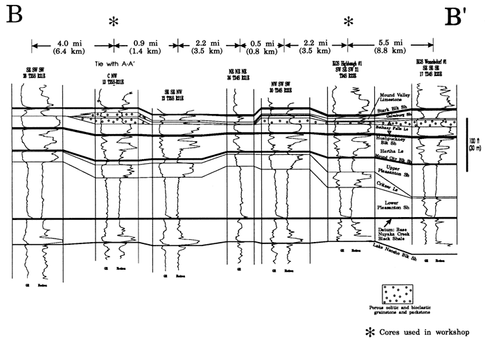
Figure 11--Detailed southwest-northeast-trending cross section (using the same wells as fig. 10) that shows the development of separate porosity zones both laterally and vertically within the Swope and Mound Valley limestones. Note the relatively abrupt lateral pinchouts of these oolitic lithofacies in both zones. [A larger Acrobat PDF version of this figure is available.]
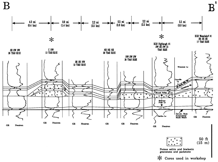
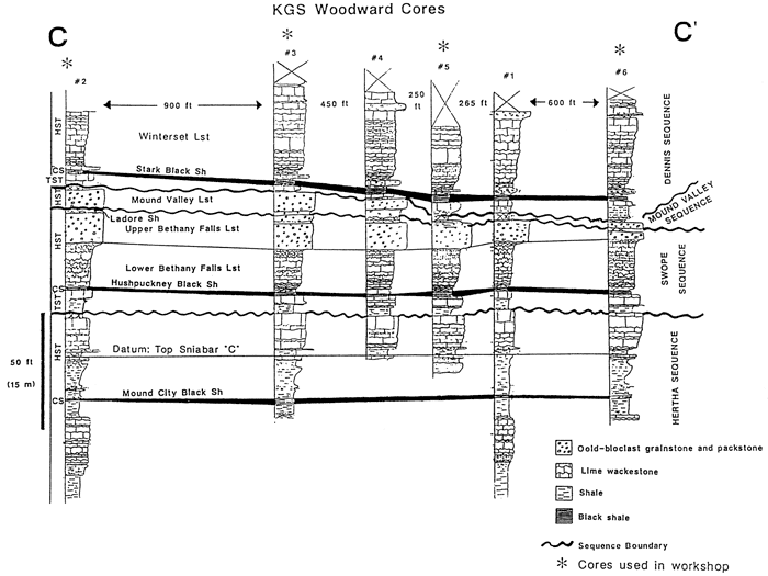
Figure 12--Detailed core transect from near the center toward the pichout of an oolitic buildup in the Swope and Mound Valley depositional sequences. Porosity in these oolites varies both laterally and vertically, being controlled in part by the distribution of paleosols and relatively fine-grained transgressive lithofacies. [A larger Acrobat PDF version of this figure is available.]
Conclusions
Carbonate grainstones similar to those that form important Missourian oil and gas reservoir facies are present in equivalent units at and near the outcrop belt in southeastern Kansas. Reservoir-type lithofacies are present in the highstand systems tracts of two distinct carbonate-dominated depositional sequences. At least two porous, oolitic zones, separated vertically and laterally by non-porous lithologies, are present. Their deposition was controlled by fluctuations of relative sea-level that were probably glacial-eustatic and therefore worldwide in extent. In addition, the geometries of porous zones within each depositional sequence appear to have been influenced by pre-existing topography. These relationships may provide clues for both exploration and production in the equivalent depositional sequences in the deeper subsurface.
Cores on display at this workshop
Portions of cores from six wells that were drilled as part of this research are on display at this workshop. Four of the cores (the KGS Woodward #2, #3, #5, and #6) are part of a six-core transect that was taken in the late spring and early summer of 1991. This transect was designed to provide information on lateral and vertical porosity variations within the Bethany Falls and Mound Valley Limestones, as was discussed previously. Another core (the KGS Mitchelson #2) is an example of the oolitic Bethany Falls where it occurs updip of the detailed transect, and the KGS Highbaugh #1 is an example of the Bethany Falls and Mound Valley Limestones where they occur in the next oolitic buildup to the north (see fig. 7). All six cores have been used in the cross sections in this paper (figs. 9-12). Additional information, including detailed core descriptions and petrographic data, will be available at the workshop.
Acknowledgments
I would like to thank Lynn Watney, Paul Enos, and Robert Goldstein for their continuing help, both logistical and conceptual. This paper was prepared with the support of the U. S. Department of Energy (DOE Grant No. DEFG22-90BC14434). However, any opinions, findings, conclusions, or recommendations expressed herein are those of the author and do not necessarily reflect the views of the DOE. This paper was reviewed by Paul Enos and Lynn Watney, and I thank them for their suggestions, which significantly improved the manuscript.
References
Ball, M. M., 1967, Carbonate sand bodies of Florida and The Bahamas: Journal of Sedimentary Petrology, v. 37, p. 556-591
Brown, Jr., L. F., and Fischer, W. L., 1977, Seismic-stratigraphic interpretation of depositional systems-Examples from Brazilian rift and pull-apart basins; in, Seismic Stratigraphy-Applications to Hydrocarbon Exploration, C. E. Payton: American Assoc. of Petroleum Geologists, Memoir 26, p. 213-248
Crowell, J. C., 1978, Gondwanan glaciation, cyclothems, continental positioning, and climate change: American Journal of Science, v. 278, p. 1,345-1,372
Galloway, W. E., and Brown, L. F., 1973, Depositional systems and shelf-slope correlations on cratonic basin margin, uppermost Pennsylvanian of north-central Texas: American Assoc. of Petroleum Geologists, Bulletin, v. 57, p. 1,185-1,218
Heckel, P. H., 1977, Origin of phosphatic black shale facies in Pennsylvanian cyclothems of midcontinent North America: American Assoc. of Petroleum Geologists, Bulletin, v. 61, p. 1,045-1,068
Heckel, P. H., 1983, Diagenetic model for carbonate rocks in midcontinent Pennsylvanian eustatic cyclothems: Journal of Sedimentary Petrology, v. 53, p. 733-759
Heckel, P. H., 1984, Factors in midcontinent Pennsylvanian limestone deposition; in, Limestones of the Midcontinent, N. J. Hyne, ed.: Tulsa Geological Society, Special Publication 2, p. 25-50
Heckel, P. H., 1986, Sea-level curve for Pennsylvanian eustatic marine transgressive-regressive depositional cycles along midcontinent outcrop belt, North America: Geology, v. 14, p. 330-334
Heckel, P. H., 1990, Evidence for global (glacial-eustatic) control over upper Carboniferous (Pennsylvanian) cyclothems in midcontinent North America; in, Tectonic Events Responsible for Britain's Oil and Gas Reserves, R. F. P. Hardman and J. Brooks, eds.: Geological Society, Special Publication 559, p. 35-47
Mitchum, R. M., Jr., VaiL P. R., and Thompson, S., III, 1977, Part H--The depositional sequence as a basic unit for stratigraphic analysis; in, Seismic Stratigraphy-Applications to Hydrocarbon Exploration, C. E. Payton, ed.: American Assoc. of Petroleum Geologists, Memoir 26, p. 53-62
Mitchum, R. M., Jr., and Van Wagoner, J. C., 1990, High-frequency sequences and their stacking patterns--sequence-stratigraphic evidence of high-frequency eustatic cycles: Sedimentary Geology, v. 70, p. 131-160
Moore, R. C., 1931, Pennsylvanian cycles in the northern midcontinent region: Illinois Geological Survey, Bulletin 60, p. 247-257
Rascoe, B., Jr., and Adler, F. J., 1983, Permo-Carboniferous hydrocarbon accumulations, midcontinent U.S.A.: American Assoc. of Petroleum Geologists, Bulletin, v. 67, p. 979-1,001
Veevers, J. J., and Powell, C. M., 1987, Late Paleozoic glacial episodes in Gondwanaland reflected in transgressive-regressive depositional sequences in Euramerica: Geological Society of America, Bullen, v. 98, p. 475-487
Watney, W. L., 1984, Recognition of favorable reservoir trends in Upper Pennsylvanian cyclic carbonates in western Kansas; in, Limestones of the Midcontinent, N. J. Hyne, ed.: Tulsa Geological Society, Special Publication 2, p. 201-246
Watney, W. L, and Stephens, B., in press, Cahoj field, Rawlins County, Kansas: American Assoc. of Petroleum Geologists, Treatise of Petroleum Geology
Watney, W. L., French, J. A., and Franseen, E. K., 1989, Sequence-stratigraphic interpretations and modeling of cyclothems: Kansas Geological Survey and Kansas Geological Society, Guidebook for the 41st annual field trip, 211 p.
Weller, J. M., 1930, Cyclical sedimentation of the Pennsylvanian Period and its significance: Journal of Geology, v. 38, p. 97-135