
Seismic Detection of Shallow Natural Gas Beneath Hutchinson, Kansas
Kansas Geological Survey
Open-file Report 2002-44
|
|
|
Kansas Geological Survey Open-file Report 2002-44 |
In February 2001, the Kansas Geological Survey conducted a high-resolution
seismic reflection 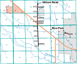 survey
in order to detect seismic anomalies, which might indicate the presence of
gas and identify potential gas pathways from Yaggy to Hutchinson.
survey
in order to detect seismic anomalies, which might indicate the presence of
gas and identify potential gas pathways from Yaggy to Hutchinson.
Data Acquisition Parameters
The seismic source was an IVI minivib (vibroseis) controlled by a linear up-sweep (5 s) from 30 to 300 Hz . The receivers were Mark Products L28E 40 Hz vertical component geophones. Three geophones, in series, were planted in 1.5 m arrays every 2.5 m along the line. Data were recorded on four 60-channel, R60 Geometrics StrataView seismographs networked for simultaneous 240-channel recording. A 6-second record with a sample interval of 0.5 ms was recorded. The source interval was 5 m. Three shots were recorded individually at each source station. A split-spread geometry was used in data acquisition.
Data Processing Flow
Interpretations
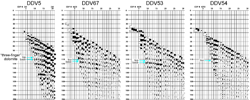
Seismic reflections on the CDP stacked data were tied to known rock formations using synthetic seismograms created with sonic and density logs from the Q-5 well in Yaggy. At the level of the “three-finger” dolomite, the Rice Park line appeared to show a dim out corresponding to the gas at DDV5. On the Wilson Road line, two amplitude anomalies, approximately 1/3 mile apart, were identified and drilled. One anomaly was a dim out (DDV54) and the other was a bright spot (DDV53). Gas was found at both locations.
Since the presence of gas produces different seismic anomalies at locations separated by 1/3 mile or less, the physical properties of the gas-bearing zone and surrounding rock layers must have significant lateral variation beneath Hutchinson. The nature of the lateral variations in physical properties was investigated using data from core and well logs.
CDP Gathers at Locations with Gas
|
|
|