
|
|
Cross Section |
| Cross Section | Description | Plot Applet | |
Work is partially supported by the U.S. Department of Energy (DOE) National Energy Technology Laboratory (NETL) under Grant Number DE-FE0002056.
"Correlation of petroleum reservoirs is a fundamental task in reservoir characterization used to establish the geometry of the reservoir and strata surrounding it and to delimit the distribution of flow units that comprise the reservoir. Correlations are primarily accomplished via construction of cross sections through the reservoir using wireline logs where depth patterns, trends, and surfaces define probable continuity within the reservoir between well locations. The correlations are validated through analyses of fluids recovered, flow tests, and possibly seismic surveys, in the later case if the reservoir is sufficiently thick to be seismically resolvable. Cross sections display the log curves at various scales and, to be effective, should show formation and reservoir tops, correlation surfaces, intervals of tests, perforations for production, and intervals that are considered flow units that are correlatable and connected between wells." GEMINI Project
NOTE: In order to plot multiple well/locations the user must either reduce the the number of well/locations that are presented at one time if the data is over a long depth range or to reduce the depth range of each well/location. A memory usage dialog is presented in both applets so the user can see how much memory the program is using on their PC.
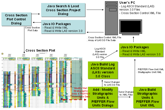
The Cross Section Project can be saved anywhere on the user's PC and the cross section control file can be any name but the filename that is provided must be a proper filename string, i.e. no spaces between words or peculiar characters. The cross section maintains the well list and the data that is generated from this program in the same directory the Cross Section Control XML file is saved. The Cross Section Control File maintains the location and filename of the data. Each well/location will be assigned a unique id generated from the date and time. The unique id becomes the prefix to all the data for each well/location. This way the program maintains the data within the program. The LAS version 3.0 Files are used to build the cross section only, but not used in any archival mode.
Author: John R. Victorine jvictor@kgs.ku.edu