| Kansas Geological Survey Open-File Report |
Index of Images || Small Web Image || Large Web Image || Acrobat PDF (16.4 Megs)
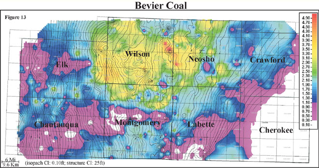
Isopach mapping of the Bevier coal reveals a coal that is laterally discontinuous and has a consistency in thickness over an average of 6 miles (9.6 km). Thickness of the Bevier coal ranges from 0 to 4.5 feet with an average of 1.5 feet and has a normal distribution (0 to 1.4 m, average of 0.5 m). The Bevier coal exhibits a lenticular geometry that is oriented parallel to depositional dip. Structure appears to influence coal thickness. The Bevier coal appears to thicken on highs and thin into lows as defined by structure contours of the base of the Bevier coal overlain onto an isopach of Bevier coal thickness. The Bevier coal is consistently thicker in the northern half of the study area especially within Wilson, and Neosho counties. Localized thin trends in areas of thicker Bevier coal may be due to erosion by fluvial processes.