Shelf/Ramp Controls on Lithofacies Distribution and Petroleum Reservoir Development
Dickman Field, Ness County Kansas Example of Recurrent Structural Activity affecting Ft. Scott, Cherokee, and Mississippian Pays
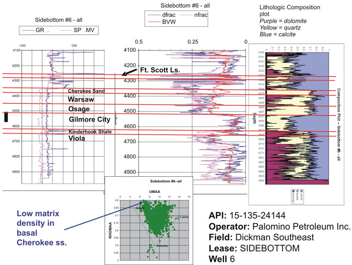
Dickman Field is located in Ness County, Kansas, in a mid-shelf setting. Primary producing intervals include the Mississippian-Upper Mississippian Spergen and Warsaw cherty dolomites and an incised valley fill Middle Pennsylvanian sandstone that lies directly and locally above the Mississippian (see well logs above). The Middle Mississippian Osage produces in nearby fields in similar reservoir types as those producing here. Some 1.7 million barrels of oil have been produced from the Mississippian cherty dolomite, Cherokee sandstone, and to a lesser extent from an oolitic facies of the Middle Pennsylvanian Ft. Scott Limestone (see well logs below).
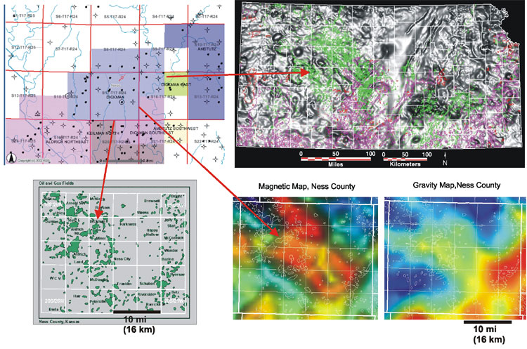
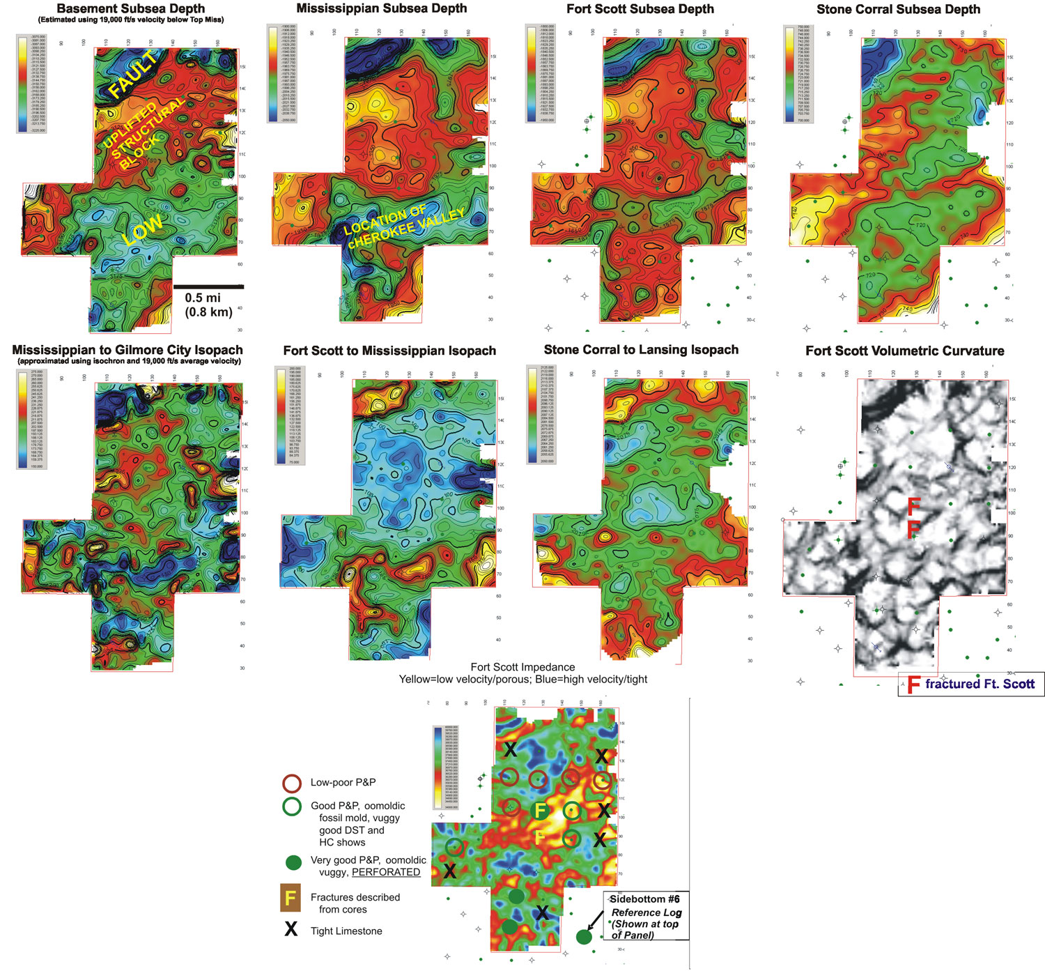
Dickman Field and this portion of the Mississippian subcrop lies along a northwest-trending basement terrane boundary. Basement lineaments at the county scale trend NW and NE. The structural picture at Dickman is revealed with a 3D seismic survey that covers the extend (~1.5 mi. x 1 mi.) of this relatively small field (images to right of text).
Three seismic interpretation processes used:
- trace picking for horizon mapping,
- volumetric curvature attribute, and
- impedence attribute computation.
Seismic images: 1) examine evidence for structural segmentation and reactivation of the local shelf and 2) aid in evaluating the potential for infill well locations in the Ft. Scott oolitic facies.
The deepest horizon illustrated in a series of 3D seismic images is the Precambrian surface followed by younger surface including the top of the Mississippian, top of Ft. Scott, and up to the much shallower Lower Permian Stone Corral Formation. Major features include a north bounding fault directly located next to a high upthrown angular block. This combination persists through every horizon. Interestingly the “incised valley” seen in the top of the Mississippian on the south end is also expressed by a general to narrow and winding low both at deeper and younger shallower horizons. The course of the Cheokee valley fill sandstone is antecedent to a persistent structural low!
Three interval isopachs arranged from old to younger show:
- consistent thickening over the northern fault,
- thinning over upthrown angular block, and
- thickening into the southern low occupied by a Cherokee channel sandstone.
Significantly, in the objective to examine the Ft. Scott potential infill development, the Ft. Scott to Mississippian isopach shows in excess of 50 ft (15 m) of thinning over the angular upthrown block suggesting a topographic high during Ft. Scott deposition -conditions favorable for shoal water oolite deposition, that is, if sea level during peritidal periods was sufficiently long to permit sufficient ooid accumulation and that diagenetic or structural enhancement to pores allowed permeable reservoir rock to evolve.
Click on above image to see more detail
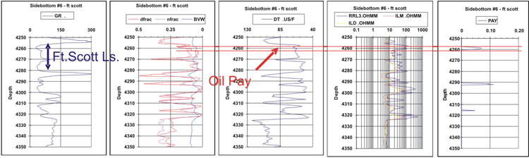
Calibration of seismic results were availed through lithologic descriptions with estimates of pore types and amounts, and drill stem test recoveries to judge relative performance regarding fluid recovery and to make estimates of permeability. Log analyses were limited, but also provided additional independent indications of potential or actual hydrocarbon pay.
The volumetric curvature describes how bent a surface is at a particular point and is closely related to the second derivative of the curve defining the surface. The resultant curvature analysis for the Ft. Scott Limestone horizon shows NW and NE “wrinkles” on that surface that may reflect fractures/joints. A similar joint system is solution-enhanced into the top of the Mississippian surface, but one set of joints is shale filled and compartmentalize that reservoir. In the Ft. Scott Limestone, on the other hand, two cored wells with abundant fractures correspond to locations of these “wrinkles”, thus validation that these are likely images of joints.
Seismic impedence modeling done at 4 milliseconds below the top of Ft. Scott resolved a patch of low velocity on the southern flank of the angular uplifted structural block corresponding to areas of higher porosity or lithology change. Sample descriptions and DST tests confirm: 1) higher velocities (blues/greens) generally tight rock, 2) lower velocities (red/yellow) good to excellent porosity in vuggy oomoldic and fossil mold lithofacies.
The key points are: 1) a fault bounded structural block was reactivated during Ft. Scott Limestone deposition focusing the deposition of reservoir facies, 2) subsequent fracturing resulting from continued uplift further enhanced the porosity through mechanical deformation and possible enhanced diagenesis, 3) sea level conditions were appropriate at Ft. Scott time to permit momentary shoal water conditions.
http://www.kgs.ku.edu/PRS/AAPG2005/controls/p2-03.html
Last Modified January 2006