Petroleum Geology
Northern Midcontinent - very mature oil and gas producing province
- 145 years production, over 350,000 wells drilled in Kansas.
- New technology and resurgence in product prices have revitalized the region
- Mississippian and Pennsylvanian reservoirs offer opportunities to recomplete existing wells and drill new wells.
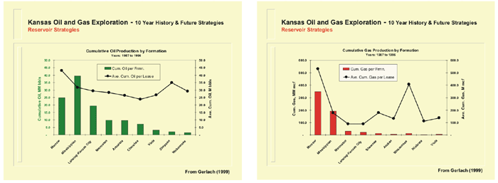
- A dominant portion of cumulative oil and gas produced in the past decade in Kansas from Mississippian and Pennsylvanian carbonate reservoirs
- High productivity from numerous stacked zones and compartmentalization due to general stratigraphic trapping
- Horizons may contain remaining economic hydrocarbons due to the subtle stratigraphic nature of traps.
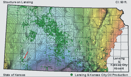 |
Structure map on top of the Lansing Group showing distribution of oil production from Upper Pennsylvanian Lansing and Kansas City Groups, predominantly cyclic, stacked carbonates. Production is focused on the Central Kansas Uplift. Arrows delineate field examples used in this paper. |
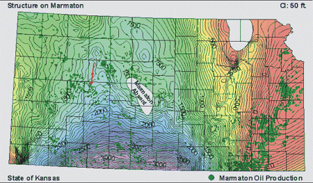 |
Structure map on the top of the Marmaton Group showing the distribution of oil production from Middle Pennsylvanian Marmaton Group reservoirs. Production is widespread throughout much of Kansas. Arrows indicate field examples that are illustrated in this paper. |
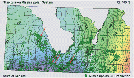 |
Structure map of the top of the Mississippian limestones showing oil production that surrounds the Central Kansas Uplift and the Nemaha Uplift, sites where the Mississippian carbonates were removed by erosion due to pre-Pennsylvanian lowstand in eustatic sea level that coincided with tectonic uplift of the shelf. |
Stratigraphy
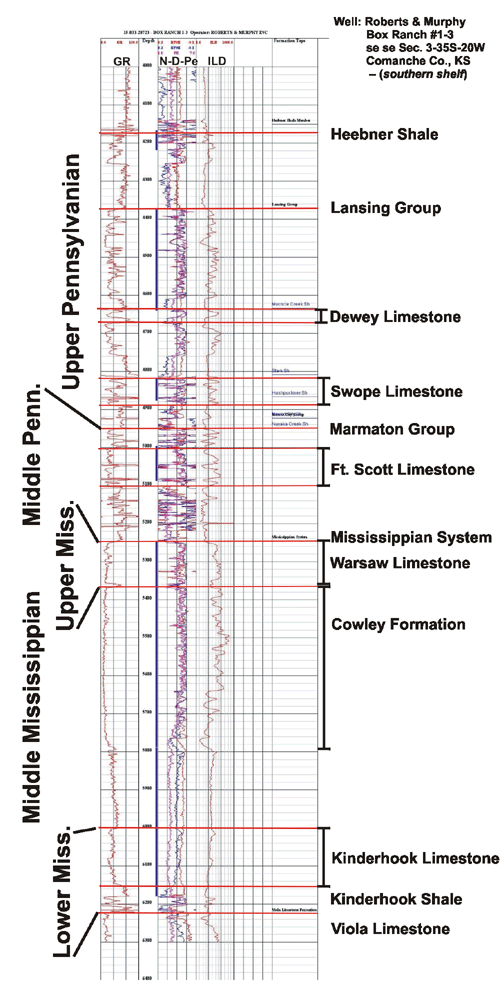
Well log depicting the stratigraphy of the intervals (highlighted) examined in this study that extends from the Upper Pennsylvanian Heebner Shale to the base of the Mississippian System
Generated using free interactive geo-engineering modeling software call GEMINI (http://www.kgs.ku.edu/Gemini)
http://www.kgs.ku.edu/PRS/AAPG2005/controls/p1-02.html
Last Modified January 2006