1999 Annual Water Level Raw Data Report for Kansas
Prev Page--Report Start || Next Page--Acquisition Activity
The Division of Water Resources (DWR) of the Kansas Department of Agriculture and the Kansas Geological Survey (KGS) manage and operate the statewide cooperative annual water level measurement program. Water level measurements are scheduled annually for about 1,400 wells spread across 47 central and western Kansas counties (Figure 1). These annual measurements are nominally made during the month of January and include wells used for stock, irrigation, household, and monitoring (some abandoned agricultural or domestic wells). The data acquired during these yearly measurements are tabulated to establish trends and allow evaluation and judgments for effective water resource management.
Figure 1--Locations of wells in 1999 water-level measurement program.
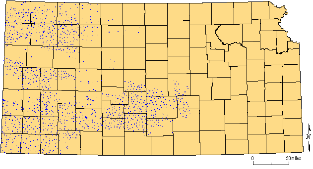
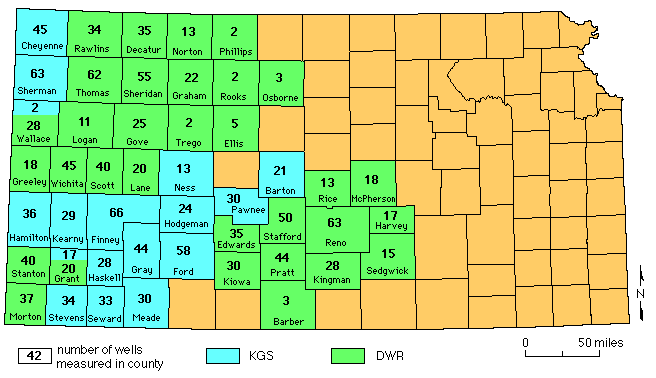
Figure 2--Number and organizational responsibility by county for the
1999 network wells.
Spatial analysis of the 1998 water level data identified 37 locations where new wells should be incorporated into the annual measurement network to eliminate sampling "holes." Cooperation between the groundwater management districts (GMDs), DWR, and KGS staff identified wells acceptable for inclusion in the network at 34 of the 37 locations. Even though only 14 of the 34 sites actually resulted in water level measurements, a procedure is developing for the incorporation of new wells into the annual network while the overall completeness of sampling continues to improve. The last two years have seen positive growth in the number of wells in the annual network in response the retirement or replacement of inconsistent, plugged, or inaccessible wells.
The Quality Control program continues to achieve its objectives of identifying and quantifying sources of unwanted variation in observation well data collection, and in flagging wells where measurements required verification. Probably the most significant outcome of the Quality Control program since its implementation in 1997 was this year's observation that the variance of the response variables in 1997 and 1999 were over three times greater than the variance in 1998. Careful study of these data for possible causes for this unexpected increase in variance uncovered a set of 24 wells with extremely erratic measurements. In most cases, wells in this set of 24 were difficult to measure and required multiple entries into the well bore. Removing these 24 wells from the 1999 data set eliminated all variation except aquifer code, and use of weighted tape. The overall quality and accuracy of the data set and any computation with or analysis of these data could be greatly improved by dropping these 24 wells from the network and replacing them with consistent and reliable wells. The value of intensive training of field measurers and incorporation of automatic location recording and guidance devices has been decisively demon-strated. As the Quality Control process is routinely applied to KGS observation well measurements in the future, and particularly if it is applied to the entire Kansas observation well network, the quality of the data will be pro-gressively improved with time.
The original observation well network designed in 1984 was based on a regular hexagonal pattern, with observation wells located at or near the centers of the hexagons. Unfortunately, some current observation wells are far from the centers of their hexagons, and some hexagons no longer contain a network well at all, resulting in "holes" in the network. The integrity of the network is being restored through the selection and measurement of new wells optimally located to fill existing undersampled areas. Determining the very best places for replacement wells requires a geostatistical study, which unfortunately delays the measurement of the water surface in undersampled areas. Replacement wells selected by measurement staff during the measurement campaign are preferred over leaving a "hole" in the network for that measurement year while waiting for a computer-aided replacement well to be selected for the following year. A good rule of thumb for field workers to use for selecting a replacement for a lost observation well is to choose a new well as close as possible to the center of the hexagon. It is possible to have holes form in the network if replacement wells deviate too far from the center of the hexagon. Yearly geostatistical studies will define undersampled areas (holes) and select optimum locations for replacement wells to eliminate extraneous holes in the network occasionally left by the hexagon system.
Prev Page--Report Start || Next Page--Acquisition Activity