1998 Annual Water Level Raw Data Report for Kansas
Prev Page--Report Start || Next Page--Acquisition Activity
The Division of Water Resources (DWR) of the Kansas Department of Agriculture and the Kansas Geological Survey (KGS) sponsor the statewide cooperative annual water level measurement program (Woods, Schloss, and Macfarlane, 1997). Water level measurements are scheduled annually for about 1,380 wells spread across 47 central and western Kansas counties (Figure 1). These annual measurements are nominally made during the month of January and include wells used for stock, irrigation, household, and monitoring (some abandoned agricultural or domestic wells). The data acquired during these yearly measurements are tabulated to establish trends and allow evaluation and judgments for effective water resource management.
Figure 1--Spatial distribution and responsible agency of annually
measured wells.
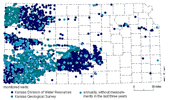
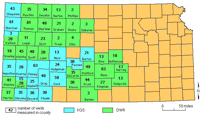
Figure 2--Counties in Water Level Measurement Program measured
in 1998 by KGS and DWR.
Spatial analysis of the 1997 water level data identified 47 locations where new wells should be incorporated into the annual measurement network to eliminate sampling "holes." Cooperation between the groundwater management districts (GMDs), DWR, and KGS staff identified wells acceptable for inclusion in the network at 28 of the 47 locations. Even though only 17 of the 28 sites actually resulted in water level measurements, this exercise establish a procedure and mechanism for optimizing (based on location, history, and measurement ease) the incorporation of new wells into the annual network. For the first time since 1985 the network should begin to experience short-term growth followed by stability instead of continuous decline.
The Quality Control program has achieved its objectives of identifying and quantifying sources of unwanted variation in observation well data collection, and in flagging wells whose measurements required verification. It is important to note that the variance of the response variable in 1997 was over three times greater than the variance in 1998. Unlike field measurements from 1997, data collected in 1998 show no significant variation attributable to any secondary effects except the aquifer being tapped by the well. This reduction in scatter reflects an improved consistency in the water level measurements in the second year of the KGS measurement program. Quality Control for the 1998 field season is markedly improved over the 1997 field season, demonstrating the usefulness of the quality control program and the success of changes in operational procedures for 1998. The value of intensive training of field measurers and the incorporation of automatic location recording devices has been decisively demonstrated. As the Quality Control process is routinely applied to KGS observation well measurements in the future, and particularly if it is applied to the entire Kansas observation well network, the quality of the data will be pro-gressively improved with time.
The original observation well network designed in 1984 was based on a regular hexagonal pattern, with observation wells located at or near the centers of the hexagons. Unfortunately, some current observation wells are far from the centers of their hexagons, and some hexagons no longer contain a network well at all, resulting in "holes" in the network. The integrity of the network can be restored by selecting and measuring new wells which are in optimal locations to fill in the existing gaps. Determining the very best places for replacement wells requires a geostatistical study, which unfortunately delays the measurement of replacement wells. A good rule of thumb for field workers to use for selecting a replacement for a lost observation well is to choose a new well as close as possible to the center of the hexagon. It is possible to have holes form in the network if replacement wells deviate too far from the center of the hexagon. Yearly geostatistical studies will define undersampled areas (holes) and select optimum locations for replacement wells to eliminate extraneous holes in the network occasionally left by the hexagon system.
Prev Page--Report Start || Next Page--Acquisition Activity