| Oil and Gas Fields Added, June 2012 | ||
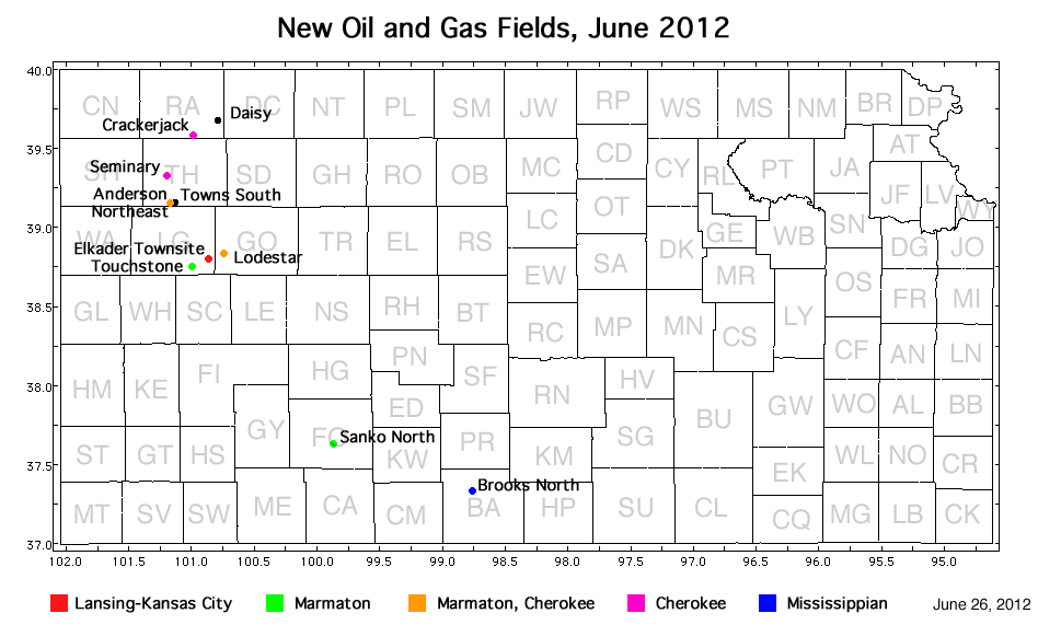
| Field | Well | Operator | API Number | Latitude | Longitude | Location | Spot | Pay Zone |
|---|---|---|---|---|---|---|---|---|
| Brooks North | Mills 1-29 | Val Energy, Inc. | 15-007-23841 | 37.3202599 | -98.762112 | sec. 29, T. 31 S., R. 13 W. | NW SW SE NW | Mississippian |
| Sanko North | Zimmerman 1-8 | Vincent Oil Corp. | 15-057-20778 | 37.6267591 | -99.868396 | sec. 8, T. 28 S., R. 23 W. | S2 NW SW NW | Marmaton |
| Lodestar | Hanna 'C' 1-14 | Lario Oil and Gas Co. | 15-063-21979 | 38.8332273 | -100.73751 | sec. 14, T. 14 S, R. 31 W. | NE NW SE SW | Cherokee and Marmaton |
| Elkader Townsite | Krebs 'A' 2-34 | Lario Oil and Gas Co. | 15-109-21085 | 38.7943852 | -100.86232 | sec. 34, T. 14 S. R. 32 W. | NE SW SW NE | Lansing-Kansas City |
| Touchstone | Gerber 1-16 | Landmark Resources, Inc. | 15-109-21076 | 38.7514101 | -100.99171 | sec. 16, T. 15 S, R. 33 W. | NE SW SW NE | Marmaton |
| Daisy | Daisy 1-27 | Murfin Drilling Co., Inc. | 15-153-20896 | 39.6776082 | -100.78564 | sec. 27, T. 4 S., R. 31 W. | NE SW SW NE | Mississippian |
| Crackerjack | Schroeder 1-25 | Murfin Drilling Co., Inc. | 15-153-20892 | 39.585358 | -100.98149 | sec. 25, T. 5 S. R. 33 W. | NW SW SW | Cherokee |
| Seminary | FS/Brenn Unit 1-26 | Red Oak Energy, Inc. | 15-193-20847 | 39.3279899 | -101.19395 | sec. 26, T. 8 S., R. 35 W. | NW SW NW SE | Cherokee |
| Towns South | Schertz 1-28 | Murfin Drilling Co., Inc. | 15-193-20841 | 39.1571109 | -101.12696 | sec. 28, T. 10 S. R. 34 W. | NW SE SW NW | Mississippian |
| Anderson Northeast | Kruto 1-29 | Murfin Drilling Co., Inc. | 15-193-20840 | 39.1535749 | -101.14271 | sec. 29, T. 10 S. R. 34 W. | NE SW NE SW | Cherokee and Marmaton |
In addition, Diebolt West in Trego County was extended to the west half a section, still producing from the Lansing-Kansas City.
|
Kansas Geological Survey, Oil and Gas Information Updated June 27, 2012 Comments to webadmin@kgs.ku.edu The URL for this page is http://www.kgs.ku.edu/Magellan/Field/NMC/june_2012.html |