currently headed by John Morrison of the Independent Oil and Gas Service, Wichita.
| Oil and Gas Fields Added, June and July 2017 | ||
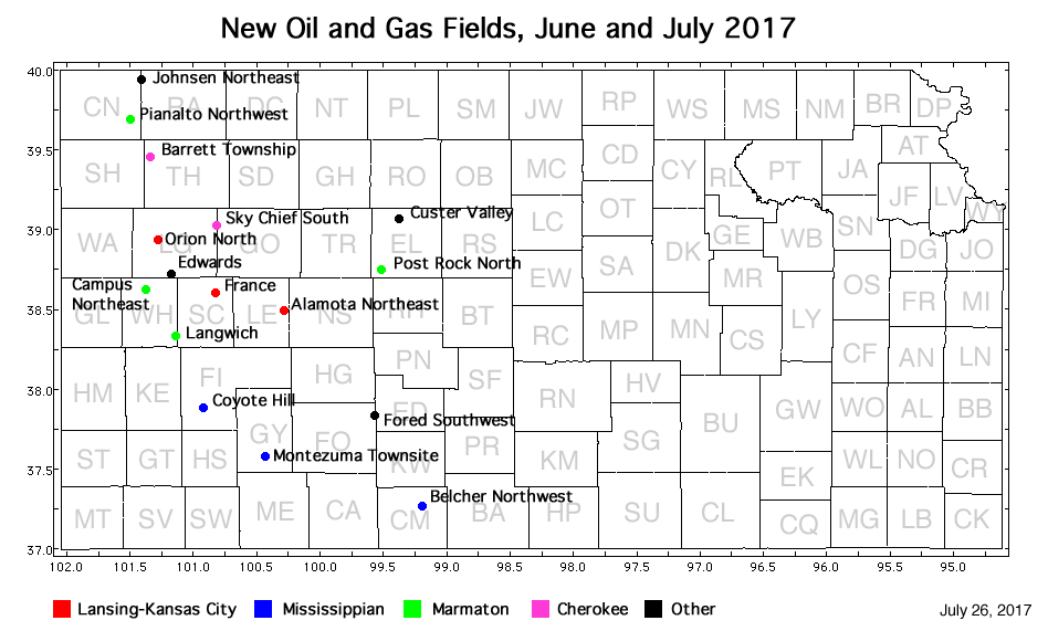
| Fields are named by the Kansas Geological Society's Nomenclature Committee, currently headed by John Morrison of the Independent Oil and Gas Service, Wichita. |
||
| Field | Well | Operator | API Number | Latitude | Longitude | Location | Pay Zone |
|---|---|---|---|---|---|---|---|
| Alamota Northeast | GOODMAN 1 | Knighton Oil Company, Inc. | 15-101-22584 | 38.4936668 | -100.2805823 | sec. 14, T. 18 S., R. 27 W. | Lansing-Kansas City |
| Barrett Township | CARPENTER TRUST 1-9 | Gulf Exploration, LLC | 15-193-20987 | 39.4617221 | -101.3426703 | sec. 9, T. 7 S., R. 36 W. | Cherokee |
| Belcher Northwest | PEOPLES OWWO 1 | Castelli Exploration, Inc. | 15-033-20733-0001 | 37.2650637 | -99.1897273 | sec. 17, T. 32 S., R. 17 W. | Mississippian |
| Campas Northeast | ALAN UNIT 1-26 | Mull Drilling Company, Inc. | 15-203-20314 | 38.6287006 | -101.3768583 | sec. 26, T. 16 S., R. 37 W. | Marmaton |
| Coyote Hill | REEVE 1 | Merit Energy Company, LLC | 15-055-22449 | 37.8807643 | -100.9184699 | sec. 14, T. 25 S., R. 33 W. | Mississippian |
| Custer Valley | Custer Valley 02-1116 | Stroke of Luck Energy & Exploration LLC | 15-051-26853 | 39.0710083 | -99.3734119 | sec. 25, T. 11 S., R. 19 W. | Conglomerate |
| Edwards | EDWARDS TRUST E 26-1 | Russell Oil, Inc. | 15-109-21497 | 38.7218691 | -101.173276 | sec. 26, T. 15 S., R. 35 W. | Marmaton and Cherokee |
| Fored Southwest | HERRMANN UNIT 'A' 1-36 | Cobalt Energy LLC | 15-057-20977 | 37.8328019 | -99.5706738 | sec. 36, T. 25 S., R. 21 W. | Cherokee, Mississippian |
| France | FRANCE 1-2 (OWWO) | BEREXCO LLC | 15-171-21001-0001 | 38.6068582 | -100.8244403 | sec. 2, T. 17 S., R. 32 W. | Lansing-Kansas City |
| Johnsen Northeast | CAROLYN 'A' 1-24 | Murfin Drilling Co., Inc. | 15-023-21463 | 39.9459865 | -101.4123243 | sec. 24, T. 1 S., R. 37 W. | Council Grove and Lansing-Kansas City |
| Langwich | LANG 1-12 | Lario Oil & Gas Company | 15-203-20316 | 38.3315405 | -101.1369697 | sec. 12, T. 20 S., R. 35 W. | Marmaton |
| Montezuma Townsite | REED TRUST 'A' 1-36 | McCoy Petroleum Corporation | 15-069-20498 | 37.5748528 | -100.4355873 | sec. 36, T. 28 S., R. 29 W. | Mississippian |
| Orion North | PLUMMER 1 | Fossil Resources LLC | 15-109-21499 | 38.9386144 | -101.281989 | sec. 11, T. 13 S., R. 36 W. | Lansing-Kansas City |
| Pianalto Northwest | HAACK-SOWERS UNIT 1 | Raymond Oil Company, Inc. | 15-023-21464 | 39.6924728 | -101.495197 | sec. 20, T. 4 S., R. 37 W. | Marmaton |
| Post Rock North | PENNEY 1-14-15-20 | Coachman Energy Operating Company LLC | 15-051-26867 | 38.7405116 | -99.5064884 | sec. 14, T. 15 S., R. 20 W. | Marmaton |
| Sky Chief South | ENGEL-BOYD UNIT 1-12 | King Oil Operation | 15-109-21490 | 39.0256257 | -100.8178042 | sec. 12, T. 12 S., R. 32 W. | Cherokee |
|
Kansas Geological Survey, Oil and Gas Information Updated July 26, 2017 Comments to webadmin@kgs.ku.edu The URL for this page is http://www.kgs.ku.edu/Magellan/Field/NMC/july_2017.html |