currently headed by John Morrison of the Independent Oil and Gas Service, Wichita.
| Oil and Gas Fields Added, February 2013 | ||
| Fields are named by the Kansas Geological Society's Nomenclature Committee, currently headed by John Morrison of the Independent Oil and Gas Service, Wichita. |
||
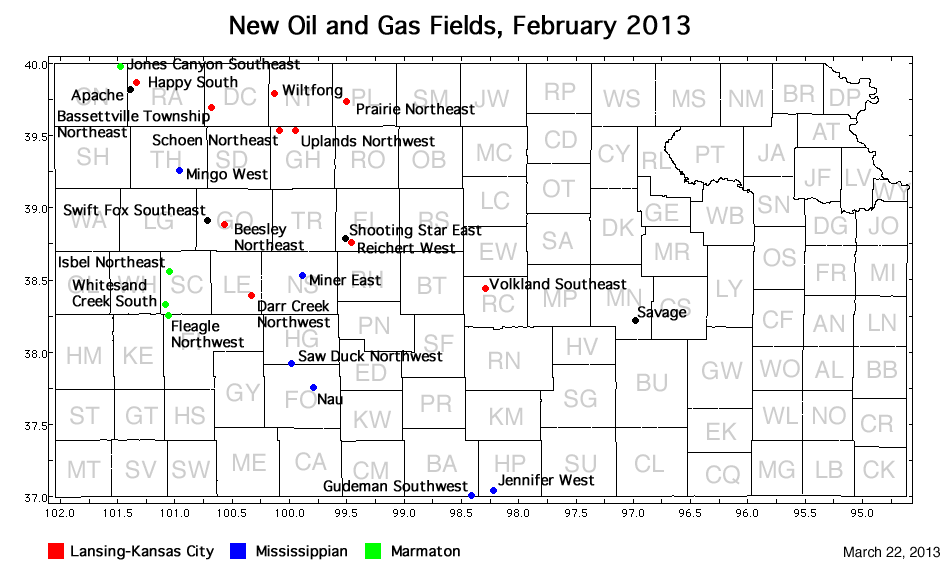
| Field | Well | Operator | API Number | Latitude | Longitude | Location | Pay Zone |
|---|---|---|---|---|---|---|---|
| Apache | CWA 'B' 1-5 | Murfin Drilling Co., Inc. | 15-153-20911 | 39.8284007 | -101.3824437 | sec. 5, T. 3 S., R. 36 W. | Lansing-Kansas City and Marmaton |
| Bassettville Township Northeast | Phillips 'A' 1-22 | Murfin Drilling Co., Inc. | 15-039-21161 | 39.693609 | -100.6716949 | sec. 22, T. 4 S., R. 30 W. | Lansing-Kansas City |
| Beesley Northeast | Ottley 1 | Charter Energy, Inc. | 15-063-22019 | 38.8771995 | -100.5625065 | sec. 32, T. 13 S., R. 29 W. | Lansing-Kansas City |
| Darr Creek Northwest | Sleeper 1-20 | Mid-Continent Energy Operating Co. | 15-101-22408 | 38.3907382 | -100.3218676 | sec. 20, T. 19 S., R. 27 W. | Lansing-Kansas City |
| Fleagle Northwest | Marabelle 1-4 | Murfin Drilling Co., Inc. | 15-055-22179 | 38.2532826 | -101.0518362 | sec. 4, T. 21 S., R. 34 W. | Marmaton |
| Gudeman Southwest | Schupbach 3510 16-1H | Shell Gulf of Mexico Inc. | 15-007-23927-0100 | 36.9992557 | -98.4103672 | sec. 16, T. 35 S., R. 10 W. | Mississippian |
| Happy Southwest | Frisbie 1-23 | Murfin Drilling Co., Inc. | 15-153-20912 | 39.8659394 | -101.3263629 | sec. 23, T. 2 S., R. 36 W. | Lansing-Kansas City |
| Isbel Northeast | Pammenter 1-26 | New Gulf Operating LLC | 15-171-20902 | 38.5527002 | -101.0431726 | sec. 26, T. 17 S., R. 34 W. | Marmaton |
| Jennifer West | Lanie 3408 1-32H | SandRidge Exploration and Production LLC | 15-077-21893-0100 | 37.0364857 | -98.2118423 | sec. 32, T. 34 S., R. 8 W. | Mississippian |
| Jones Canyon Southeast | Mears 'A' 1-9 | Berexco, LLC | 15-023-21354 | 39.9832661 | -101.4689621 | sec. 9, T. 1 S., R. 37 W. | Marmaton |
| Miner East | Nichepor 1-32H | Tug Hill Operating, LLC | 15-135-25418-0100 | 38.523445 | -99.8832644 | sec. 32, T. 17 S., R. 23 W. | Mississippian |
| Mingo West | Herbel 11B-24-933 | FIML Natural Resources, LLC | 15-193-20862 | 39.2551351 | -100.9557119 | sec. 24, T. 9 S., R. 33 W. | Mississippian |
| Nau | Nau 25C 1 | Ritchie Exploration, Inc. | 15-057-20848 | 37.7539385 | -99.7910717 | sec. 25, T. 26 S., R. 23 W. | Mississippian |
| Prairie Northeast | Forssberg 1 | Bach Oil Production | 15-147-20695 | 39.7347889 | -99.50247 | sec. 6, T. 4 S., R. 19 W. | Lansing-Kansas City |
| Reichert West | Dinges Family 1 | TDI, Inc. | 15-051-26346 | 38.7652965 | -99.4589201 | sec. 8, T. 15 S., R. 19 W. | Lansing-Kansas City |
| Savage | Savage 'A' 1 | Range Oil Co., Inc. | 15-115-21435 | 38.213559 | -96.9796808 | sec. 22, T. 21 S., R. 4 E. | Hunton |
| Saw Duck Northwest | Rebein 1 | Ritchie Exploration, Inc. | 15-083-21846 | 37.9179584 | -99.9760172 | sec. 32, T. 24 S., R. 24 W. | Mississippian |
| Schoen Northeast | Schoen 1-14 | Blue Ridge Petroleum Corp. | 15-065-23871 | 39.5338016 | -100.0832433 | sec. 14, T. 6 S., R. 25 W. | Lansing-Kansas City |
| Shooting Star East | Armbruster 1 | Zinszer Oil Co., Inc. | 15-051-26433 | 38.7819987 | -99.5105929 | sec. 2, T. 15 S., R. 20 W. | Lansing-Kansas City and Arbuckle |
| Swift Fox Southeast | Zimmerman 1-24 | Crawford Oil and Gas Co LLC | 15-063-22032 | 38.910092 | -100.7068364 | sec. 24, T. 13 S., R. 31 W. | Mississippian |
| Volkland Southeast | Burdette 1 | Primal Energy O&G, LLC | 15-159-22702 | 38.4412039 | -98.2897961 | sec. 35, T. 18 S., R. 9 W. | Lansing-Kansas City |
| Uplands Northwest | Workman Trust 13-1 | H & C Oil Operating Inc. | 15-065-23866 | 39.5355132 | -99.9454113 | sec. 13, T. 6 S., R. 24 W. | Lansing-Kansas City |
| Whitesand Creek South | Moore 1-9 | Abercrombie Energy, LLC | 15-171-20918 | 38.3277438 | -101.0758687 | sec. 9, T. 20 S., R. 34 W. | Marmaton |
| Wiltfong | Wiltfong 1 | Great Plains Energy, Inc. | 15-137-00169-0001 | 39.7905635 | -100.1318581 | sec. 15, T. 3 S., R. 25 W. | Lansing-Kansas City |
|
Kansas Geological Survey, Oil and Gas Information Updated March 22, 2013 Comments to webadmin@kgs.ku.edu The URL for this page is http://www.kgs.ku.edu/Magellan/Field/NMC/feb_2013.html |