currently headed by John Morrison of the Independent Oil and Gas Service, Wichita.
| Oil and Gas Fields Added, December 2012 | ||
| Fields are named by the Kansas Geological Society's Nomenclature Committee, currently headed by John Morrison of the Independent Oil and Gas Service, Wichita. |
||
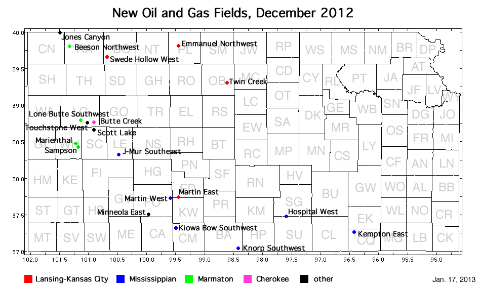
| Field | Well | Operator | API Number | Latitude | Longitude | Location | Pay Zone |
|---|---|---|---|---|---|---|---|
| Beeson Northwest | Sramek 'B' 1-11 | Murfin Drilling Co., Inc. | 15-153-20906 | 39.8069116 | -101.3275038 | sec. 11, T. 3 S., R. 36 W. | Marmaton |
| Butte Creek | Rose Been Unit 1-8 | Lario Oil and Gas Co. | 15-109-21116 | 38.7606388 | -100.8977205 | sec. 8, T. 15 S., R. 32 W. | Cherokee |
| Emmanuel Northwest | Miller 2 | Pioneer Resources | 15-147-20666 | 39.8154824 | -99.4454276 | sec. 3, T. 3 S., R. 19 W. | Lansing-Kansas City |
| Hospital West | Pauly 3002 6-1H | Shell Gulf of Mexico Inc. | 15-191-22660-0100 | 37.4741533 | -97.5843567 | sec. 6, T. 30 S., R. 2 W. | Mississippian |
| J-Mur Southeast | Jasper 12H 2 | EnCana Oil and Gas (USA) Inc. | 15-101-22381-0100 | 38.3221973 | -100.4762917 | sec. 12, T. 20 S., R. 29 W. | Mississippian |
| Jones Canyon | Shones Unit 1-5 | Murfin Drilling Co., Inc. | 15-023-21353 | 39.9954743 | -101.4880646 | sec. 5, T. 1 S., R. 37 W. | Lansing-Kansas City and Marmaton |
| Kempton East | Stelbar 1A-21-32-9 | Nadel and Gussman LLC | 15-019-27135-0100 | 37.2580781 | -96.4222688 | sec. 21, T. 32 S., R. 9 E. | Mississippian |
| Knorp Southwest | Schupbach 3510 4-1H | Shell Gulf of Mexico Inc. | 15-007-23853-0100 | 37.034833 | -98.4121716 | sec. 4, T. 35 S., R. 10 W. | Mississippian |
| Lone Butte Southwest | Byron 1-31 | New Gulf Operating LLC | 15-109-21114 | 38.7910429 | -101.1370034 | sec. 31, T. 14 S., R. 34 W. | Marmaton |
| Marienthal | Graff Christensen Unit 1-20 | Lario Oil and Gas Co. | 15-203-20186 | 38.4742516 | -101.218045 | sec. 20, T. 18 S., R. 35 W. | Marmaton |
| Kiowa Bow Southwest | Edmonston 1-28H | Tug Hill Operating, LLC | 15-033-21618-0100 | 37.3093057 | -99.4926024 | sec. 28, T. 31 S., R. 20 W. | Mississippian |
| Martin East | Miller Trust 1-36 | Strata Exploration, Inc. | 15-047-21610 | 37.7355399 | -99.4519629 | sec. 36, T. 26 S., R. 20 W. | Lansing-Kansas City |
| Martin West | Jochems 2721 2-2H | SandRidge Exploration and Production LLC | 15-057-20832-0100 | 37.7182404 | -99.5848146 | sec. 2, T. 27 S., R. 21 W. | Mississippian |
| Minneola East | Lokken 1-29 | Vincent Oil Corp. | 15-057-20823 | 37.499114 | -99.9626295 | sec. 29, T. 29 S., R. 24 W. | Morrow and Mississippian |
| Sampson | Sampson 1-10 | Lario Oil and Gas Co. | 15-203-20190 | 38.4216271 | -101.1771432 | sec. 10, T. 19 S., R. 35 W. | Lansing-Kansas City and Marmaton |
| Scott Lake | Welch 1-18 | Murfin Drilling Co., Inc. | 15-171-20905 | 38.6589338 | -100.9038635 | sec. 18, T. 16 S., R. 32 W. | Atoka |
| Swede Hollow West | Sauvage 1-34 | Murfin Drilling Co., Inc. | 15-039-21153 | 39.6685695 | -100.6791859 | sec. 34, T. 4 S., R. 30 W. | Lansing-Kansas City |
| Touchstone West | Wray 1-17 | Stelbar Oil Corp., Inc. | 15-109-21099 | 38.7530509 | -101.0132046 | sec. 17, T. 15 S., R. 33 W. | Lansing-Kansas City and Morrow |
| Twin Creek | Thompson Trust 1-1 | Dreiling Oil, Inc. | 15-141-20449 | 39.3043723 | -98.6115474 | sec. 1, T. 9 S., R. 12 W. | Lansing-Kansas City |
|
Kansas Geological Survey, Oil and Gas Information Updated Jan. 24, 2013 Comments to webadmin@kgs.ku.edu The URL for this page is http://www.kgs.ku.edu/Magellan/Field/NMC/dec_2012.html |