Kansas Geological Survey, Open-file Report 2017-48
KGS Open File Report 2017-48
Kansas Water Office, Contract 17-104
October 2017
The complete text of this report is also available as an Adobe Acrobat PDF file (1 MB).
In 2016, the Risk Management Agency (RMA) of the U.S. Department of Agriculture funded the Kansas Water Office (KWO) to develop resources that support activities in the RMA's Topeka Regional office while also increasing the awareness of expanded limited crop insurance opportunities across Kansas. Through this effort, the KWO sub-contracted with the Kansas Geological Survey (KGS) to develop an online tool to facilitate the review of limited irrigation crop insurance applications by providing real-time access to historic water use information in combination with RMA calculations of crop yield reductions under limited irrigation practices. This online tool can also be used to explore possible water use reductions and potential effects on crop yields under proposed Water Conservation Areas or Local Enhanced Management Area plans.
The RMA tool is a stand-alone, data-driven website, developed using Adobe ColdFusion web authoring software. The site provides real-time access to reported water use information from the Water Information Management and Analysis System (WIMAS) and RMA yield tables for limited irrigation applications. WIMAS is a separate online resource, hosted by the KGS, that allows access to Kansas water right data maintained by the Kansas Department of Agriculture, Division of Water Resources (KDA-DWR). WIMAS data are updated daily. Potential yield reductions resulting from reduced water applications are taken from county-based, deficit irrigation tables provided by the RMA.
The RMA Documentation Tool for Limited Irrigation is a data-driven, stand-alone website that displays information based on a unique identification number provided for a specified Kansas water right. This ID can be passed from other applications, entered manually, or, for this project, looked up using the Water Right Selection web page:
https://geohydro.kgs.ku.edu/geohydro/rma/wr_lookup.cfm
Kansas water rights are referred to in a variety of ways with the most common being the "file number." A file number consists of combinations of a water right's type, vested county code, water right number, and water right qualifier.
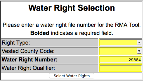
The majority of water rights in Kansas are appropriated water rights and can be looked up simply by entering the water right number. For example, to retrieve information about file number/water right 29884, enter its number in the Water Right Number field while leaving all the other fields blank (fig. 1). Because every file number has a water right number, this is a required field.
Figure 1—Appropriated water right query example.
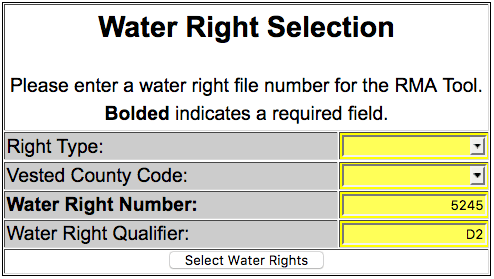
Sometimes, individual water rights are divided for administrative reasons. When this is the case, the Water Right Qualifier field must be used to find the water right's unique identification number. For example, file number 5245-D2 is composed of water right number "5245" and water right qualifier "D2" (fig. 2). By default, water rights without water right qualifiers are left blank or specified as "00."
Figure 2—Split water right qualifier query example.
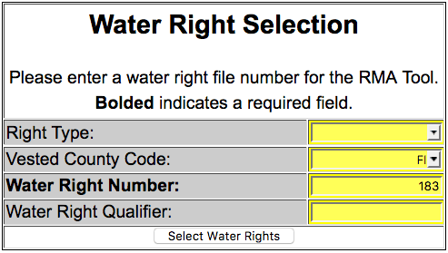
If the file number represents a vested water right (those that pre-date the 1945 Kansas Water Appropriation Act), the abbreviation for the county in which the water right is located must be selected from the Vested County Code drop-down list. An example of a vested water right is FI-183, where FI is the vested county code and 183 is the water right number. Both need to be specified (fig. 3). Because the water right qualifier isn't needed in this example, the Water Right Qualifier field can be left blank.
Figure 3—Vested water right query example.
Finally, in rare circumstances, the right type for a file number may be needed. These cases involve term (T), temporary (P), basin term (B), or some domestic (D) water rights. If appropriated (A) or vested (V) rights are specified, this drop-down list can remain blank.
Once all the necessary fields have been specified, the Water Right Selection Page queries the WIMAS database to retrieve the WR_ID value for that water right. The WR_ID is an internal number that uniquely identifies a water right. Unlike the components that make up a water right file number, in which the values have meaning relative to each other (e.g., right type, vested county code, water right number, and water right qualifier), the WR_ID is used primarily to facilitate application and database development. It is an arbitrary number that never changes once assigned and is not used to reference a water right on public forms or certificates. Instead, it is used primarily by programmers.
If the query parameters are successful, the WR_ID for the specified water right will be passed to the RMA Documentation Tool website as a URL variable. If no matching water right record is found, all the components that make up the specified file number will be listed and the user will be prompted to adjust the query.
The RMA Documentation Tool for Limited Irrigation provides access to past years of reported water use for a water right in combination with RMA-based, calculated crop yields under proposed limited irrigation applications. To open the page, an individual water right must be specified in the URL string by its WR_ID number, which is a unique internal ID assigned by the KDA-DWR to represent a single water right. Without the WR_ID reference, the website will return an error message to the user.
For example, the following URL string lists the RMA tool's web address with the WR_ID value for vested right FI-183 shown in figure 3:
https://geohydro.kgs.ku.edu/geohydro/rma/yield_tool.cfm?wr_id=49909
The URL variable, called "WR_ID," is listed immediately after the question mark in the URL string and its value, 49909, follows the equal sign. The use of URL variables allows the RMA tool to be accessed from a variety of web- and desktop-based applications. It can also be opened by manually typing or cutting/pasting the URL string directly into the address bar of a web browser.
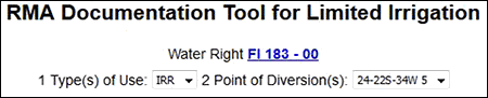
At the top of the page, the RMA tool displays the water right's file number, the types of use made of water, and the points of diversion associated with the right (fig. 4). The water right file number is composed of the vested county code (if applicable), the water right number, and the water right's qualifier. The water right file number is hyperlinked to the WIMAS website, which provides additional information, such as the priority date, authorized annual quantities and rates, and any associated records from driller's logs and depth-to-water measurements.
Figure 4—Example of a listed water right and its type of water use and points of water diversion.
When the page is opened, the RMA tool queries the WIMAS database for the last 10 years of reported water use along with contact information for the water use correspondent on record with the KDA-DWR. Reported water use is stored in WIMAS by a water right, its specific use made of water, and a specific point of water diversion. If the values in the use made of water or point of diversion dropdown boxes on the RMA tool change (fig. 4), the website re-populates with new water use information from WIMAS.
The user will be notified if the water right, the selected use made of water, or the selected point of diversion is dismissed or inactive.
The RMA Documentation Tool has several numbered data fields, some unique to the RMA and others to the reported water use. Yellow shading indicates the field's values can be edited and will be applied to other tools used within the page once the user clicks the Update Form button, located at the bottom of the web page. Light blue shading indicates the field's values are computed based on other data values on the page and cannot be edited. The RMA Documentation Tool does not save any of the information entered or changed on this page. If the water right information displayed is incorrect, the user must contact the KDA-DWR to properly update the water right record.
Data fields in this part of the form identify the county in which the selected point of diversion is located (a key parameter for RMA's yield calculations) along with contact information for the water use correspondent (fig. 5). Yellow-shaded fields can be edited.
Figure 5—Example of data fields 1 to 9.

These fields specify the crop to be grown, the type of irrigation system to be used, and various designations representing the irrigated acres (fig. 6). The values provided in Field 10 (insured crop) and Field 11 (system type) are critical and are used to estimate reductions in yields based on RMA deficit irrigation tables.
Figure 6—Example of data fields 10 to 15.
![]()
This section of the form displays reported water use along with user specified yield information for the purpose of identifying average acre-foot per acre water usage and average yield conditions for a given crop type (fig. 7). Users can include or exclude years of water use years that are used to establish average conditions from which estimates of proposed future water use reductions and any RMA's computed reductions in yield for a given crop type and irrigation system are compared against.
Figure 7—Example of data fields 16 to 21.
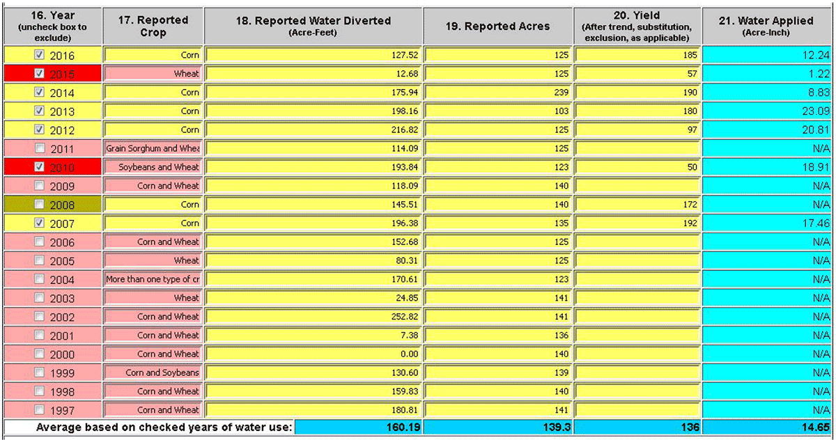
By default, the RMA Tool provides the last ten years of reported water use, queried from WIMAS for the listed water right and its specified use made of water and point of diversion. Water use reports are required to be submitted each year by March 1st. At which time, they undergo a six to nine month quality control review before being approved for public use. Water use for the 2017 calendar year, for example, should be available in late summer to early fall of 2018.
When the page is loaded or undergoes a hard refresh caused by changing the use made of water or point of diversion values at the top of the page, the water use years are automatically checked if the reported crop type in Field 17 matches the insured crop in Field 10. Years in which Field 17 and Field 10 do not match are unchecked. If a user manually checks or unchecks boxes in Field 16, those selections are maintained when the user clicks the Update Form button at the bottom of the screen.
Shading patterns:
Shading patterns:
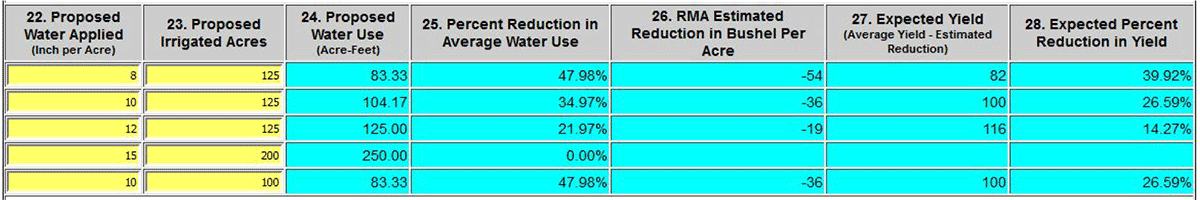
Fields 22 to 29 (fig. 8) are designed to evaluate proposed water use applications for limited irrigation agreements or possible inclusion in other management activities, such as enrolling in a Water Conservation Area. Proposed water use applications are compared to the established average conditions displayed in the last row of Fields 18 through 21 and to any reductions in bushels per acre computed from RMA's deficit irrigation cropping templates based on the selected crop type—corn or soybeans—and irrigation system. Users can specify up to five different water use proposals at once.
Figure 8—Examples of data fields 22 to 28.
The RMA Documentation Tool serves primarily as a planning tool and does not save any of the information entered or changed on the page. Once the pertinent information is entered, users can to save the page as a stand-alone web page or print to a hard copy format. Future developments may include more robust printing options or the option to export to a spreadsheet.
The authors acknowledge Shawn Beach of the USDA Risk Management Agency for his assistance, overview, and testing of the online tool; and Geoff Bohling of the KGS Geohydrology Section and Julie Tollefson, KGS editor, for their reviews of this final report.
Kansas Geological Survey, Geohydrology
Placed online July 17, 2017
Comments to webadmin@kgs.ku.edu
The URL for this page is http://www.kgs.ku.edu/Hydro/Publications/2017/OFR17_30/index.html