Kansas Geological Survey, Open-file Report 2008-30
by
Donald O. Whittemore
KGS Open File Report 2008-30
Kansas Corporation Commission
December 2008
The Kansas Corporation Commission (KCC) requested that the Kansas Geological Survey (KGS) identify the source of saltwater affecting water at the Weber study site in Russell County. The KCC collected and sent water samples to the KGS where they were analyzed. The KGS used a procedure based primarily on mixing curves on a plot of bromide/chloride ratio versus chloride concentration, as well as the concentrations of other constituents in the water samples. The results of the source identification are listed in Table 1 and the concentrations and ratios of constituents in the water samples are in Table 2.
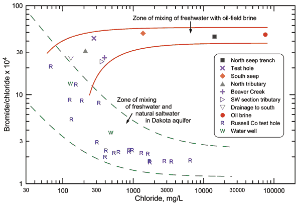
The Dakota aquifer in Russell County contains natural saline water derived from the upward intrusion of saltwater from underlying Permian strata. The source of the Permian saltwater is dissolution of rock salt, which has a very low bromide/chloride (Br/Cl) ratio. Oil brine in Kansas typically has a relatively high Br/Cl ratio. Figure 1 displays points for the water and oil brine samples collected from the Weber area, as well as for water samples collected from test holes in T13S-11W and -12W and 14S-11W and -12W drilled in 1992 and 1993 as a part of an exploration for additional water supply for the City of Russell by a consulting company and sent to the KGS for analysis, and for water samples collected from water wells in Sec. 14-T15S-12W and Sec. 12-T16S-12W and analyzed by the KGS. Each of the curves on Figure 1 represents the mixing line between two end points and is based on algebraic equations for the mixing of bromide and chloride in the two end-member waters. The pair of curves defining the zone of mixing between freshwater and natural saltwater in the Dakota aquifer bracket the Br/Cl ratios of the points representing the waters from the Russell County test holes and the two water wells. The pair of curves defining the zone of mixing between freshwater and oil-brine bracket the Br/Cl ratios of the Weber site waters and oil brine and extend into the upper part of the mixing zone for the mixing of freshwater and natural saltwater in the Dakota aquifer.
The Br/Cl ratios of the water samples from the Weber area plot at higher Br/Cl ratios than expected for the mixing of freshwaters with natural saltwater in the Dakota aquifer. The Weber area waters fit the mixing of water from the Dakota aquifer with a chloride content between approximately 70 and 200 mg/L and the oil brine collected from the site. The estimates of natural and oil-brine sources in Table 1 are based on visual estimates of how individual mixing curves starting from the oil-brine point in Figure 1 and passing through each point for the Weber waters would be extrapolated into the upper part of the zone of mixing between freshwater and saltwater in the Dakota aquifer. Although the water samples from the SE quarter of Section 27, T15S-R12W have the highest chloride content and contribution from oil brine, it is clear that a low-level contribution of oil brine affects the other water samples as well. This is probably from the slow flushing of past oil-brine contamination of the soil and ground water within the oil field that covers the study area.
Although sulfate/chloride (SO4/Cl) ratios are often useful in supplementing the Br/Cl mixing curve identification, the separation of mixing zones for Dakota saltwater and the Weber oil brine on a SO4/Cl versus chloride concentration plot is not nearly as great as for the Br/Cl zones. However, the general trend of decreasing SO4/Cl ratio with increasing chloride content for the waters, especially for the south seep and north seep trench waters, fits well the very low SO4/Cl ratio for the oil brine. Dakota saltwater with a chloride concentration greater than several thousand mg/L in Russell County generally has a SO4/Cl ratio in the range 0.1-0.3. The nitrate content of the Weber water samples is very low, indicating that there is no significant contribution of chloride from slightly saline animal waste.
Table 1. Total chloride concentration analyzed, and natural and oil-brine sources of chloride estimated in water samples collected from the Weber study site in Russell County in November 2008. Source chloride values are rounded to the nearest 10 mg/L.
| Field no. |
Site name | Legal location* | Total Cl mg/L |
Natural Cl mg/L |
Oil brine Cl mg/L |
|---|---|---|---|---|---|
| 1 | South seep | 15S-12W-27DDB | 1,381 | 70 | 1,310 |
| 2 | Drainage to south | 15S-12W-34CAAD | 130 | 90 | 40 |
| 3 | SW corner of section tributary |
15S-12W-27CCCD | 362 | 200 | 160 |
| 4 | North tributary | 15S-12W-22CDCC | 209 | 100 | 110 |
| 5 | Beaver Creek | 15S-12W-22CDCC | 390 | 200 | 190 |
| 6 | North seep trench | 15S-12W-27DABD | 14,291 | 100 | 14,190 |
| 8 | Test hole--west drainage |
15S-12W-27DACD | 276 | 70 | 210 |
| Letters after the section number represent larger to smaller quarters, where A = NE, B = NW, C = SW, and D = SE. | |||||
Table 2. Location information and chemical analyses of samples collected from the Weber study site, Russell County. All samples were collected on November 7, 2008 by Case Morris and Bruce Bayse, Kansas Corporation Commission.
| KGS lab no. |
Field no. | Site name | Legal location | Latitude, longitude | Lab SpC uS/cm | Cl mg/L | SO4 mg/L | NO3-N mg/L | Br mg/L | Br/Cl x 104 mass ratio | SO4/Cl mass ratio |
|---|---|---|---|---|---|---|---|---|---|---|---|
| 080253 | 1 | South seep | 15S-12W-27DDB | 38.71392, 98.63693 |
4,820 | 1,381 | 78.7 | <0.03 | 6.75 | 48.8 | 0.0570 |
| 080254 | 2 | Drainage to south | 15S-12W-34BAAD | 38.70982, 98.64345 |
1,254 | 130 | 151 | <0.03 | 0.334 | 25.6 | 1.160 |
| 080255 | 3 | SW corner of section tributary | 15S-12W-27CCCD | 38.71134, 98.65058 |
2,060 | 362 | 260 | <0.03 | 0.851 | 23.5 | 0.719 |
| 080256 | 4 | North tributary | 15S-12W-22CDCC | 38.72609, 98.64690 |
1,727 | 209 | 251 | 0.26 | 0.651 | 31.1 | 1.197 |
| 080257 | 5 | Beaver Creek | 15S-12W-22CDCC | 38.72613, 98.64700 |
2,433 | 390 | 370 | 0.14 | 1.01 | 26.0 | 0.949 |
| 080258 | 6 | North seep trench | 15S-12W-27DABD | 38.71714, 98.63704 |
36,800 | 14,291 | 99.7 | <0.03 | 64.2 | 44.9 | 0.00698 |
| 080259 | 7 | Oil brine from tank | 15S-12W-27D* | 150,700 | 75,597 | 13.0 | 0.06 | 358 | 47.3 | 0.00017 | |
| 080260 | 8 | Test hole--west drainage | 15S-12W-27DACD | 38.71573, 98.63654 |
2,214 | 276 | 204 | 0.17 | 1.19 | 43.0 | 0.740 |
| * Brine from saltwater tank that receives oil brine produced from two oil wells located in Sec. 27DAA & 27DCCB. Based on information in the oil and gas information data base of the Kansas Geological Survey, the oil wells produce primarily from the Lansing-Kansas City groups. | |||||||||||
Figure 1. Bromide/chloride mass ratio versus chloride concentration for waters and oil brine from the Weber site, and from test holes and water wells in Russell County.
Read the PDF version (48 kB)
Kansas Geological Survey, Geohydrology
Updated March 4, 2010
Comments to webadmin@kgs.ku.edu
The URL for this page is http://www.kgs.ku.edu/Hydro/Publications/2008/OFR08_30/index.html