Kansas Geological Survey, Open-file Report 2000-19
by
Donald Whittemore, David Young, and John Healey
Arkansas River Corridor Study
A Kansas Water Plan Project
April 12, 2000
KGS Open-file Report 2000-19
Three sites with multi-level monitoring wells were installed in the Arkansas River corridor as a part of the study. They are located in Deerfield, in Garden City, and just west of Dodge City. The sites have helped to document the fate of saline Arkansas River water and the link between increased contamination in the High Plains aquifer and lowered ground-water tables.
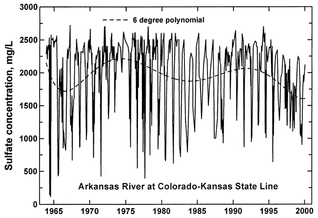
Arkansas River water entering Kansas from Colorado is saline. The total dissolved solids (TDS) concentration is usually in the range 2,000-4,000 mg/L and exceeds 3,000 mg/L at the average flow of the last two decades. Although the constituents in the water are primarily derived from natural soil and bedrock sources, the current high concentrations are not natural but produced by evapotranspiration losses of water in Colorado that leave the dissolved solids in the residual water. During many summers, most of the river water crossing the Colorado-Kansas line derives from irrigation return flows. The main dissolved constituent in the river water is sulfate. Sulfate concentrations range widely depending on flow and are typically in the range 1,000-2,500 mg/L (Figure 1). Annual high flows contain lower contents and low flows have high concentrations. Long-term averages have also fluctuated (see the dashed curve in Figure 1) from high concentrations during years of lower flows such as the mid-1970's, to lower concentrations such as during the higher flows of the last several years.
Figure 1. Sulfate concentration in Arkansas River water collected near Coolidge, Kansas, during 1963-2000.
Infiltration of Arkansas River water into the subsurface appears to have affected mainly shallow ground water in the river corridor from the late 1800's (after ditch irrigation began) to the early 1970's. During the 1970's, the rate of water-level declines in the High Plains (Ogallala) aquifer in the river corridor increased. The water levels dropped below the shallow zone of the aquifer and allowed the saline water to move down into the main aquifer. This occurrence is illustrated by data from the Garden City well site.
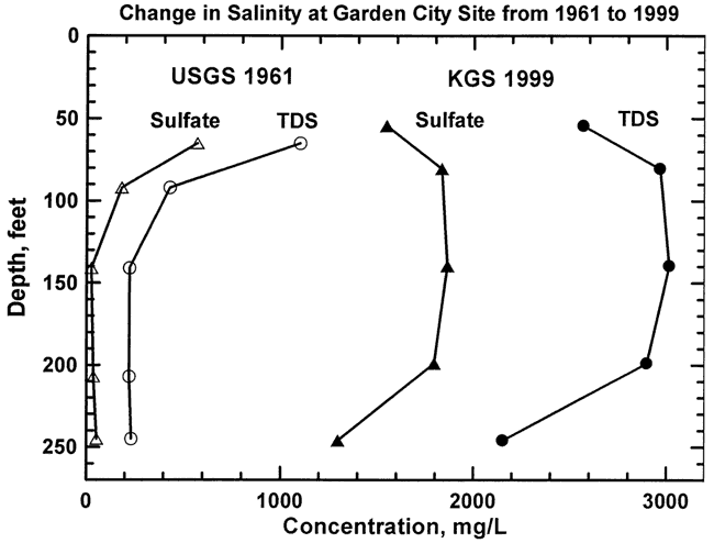
The multi-level well site at Garden City is located 1/4 mile south of the Arkansas River. The site includes 5 wells that range in depth from 59 ft to 251 ft and have 10 ft screened intervals (Figure 2). The site was selected to be as close as possible (about 150 yards distant) from test holes bored and sampled by the U.S. Geological Survey in 1961. The well depths for the new site were selected to be similar to the sampling depths of the USGS test holes. In 1961, only the shallow alluvial aquifer contained saline water; the main aquifer yielded very fresh water (Figure 3). Today, the water in the alluvial aquifer is much more saline than in 1961 and the shallow salinity has penetrated to the bottom of the aquifer. The aquifer sediments are generally more permeable and the clay units thinner at the Garden City site than at other locations where the salinity has not yet reached the lowermost aquifer. From 1997 to 1999, the salinity of water from the shallowest well has decreased, while the salinity at the middle (#3) well has increased somewhat. This represents aquifer recharge by fresher water in the river over the last few years and the downward movement of older, more saline water (see also Figure 1).
Figure 2. Garden City monitoring site, Finney County. NW NE SW sec. 19, T. 24 S., R. 32 W. Data from March 1999.
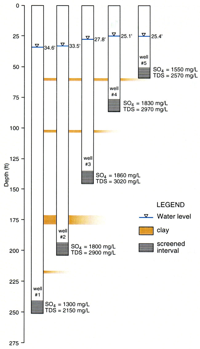
Figure 3. Change in sulfate and total dissolved solids (TDS) concentrations at the Garden City multi-level well site.
Kansas Geological Survey, Geohydrology
Placed online Nov. 13, 2007, original report dated April 2000
Comments to webadmin@kgs.ku.edu
The URL for this page is http://www.kgs.ku.edu/Hydro/Publications/2001/OFR00_19/index.html