Kansas Geological Survey, Open-file Report 81-16
KGS Open File Report 81-16
A Report to the Kansas Department of Health and Environment
The Lower Paleozoic aquifers (principally the Cambro-Ordovician) in southeast Kansas and adjoining areas are an important resource producing fresh water for municipal water supplies, industries, and agriculture in eastern sections of the region. To the west in Labette and Montgomery counties these aquifers produce oil and at one location in Montgomery County the Cambro-Ordovician is used for industrial waste disposal through well injection. The Mississippian and Cambro-Ordovician aquifers, both areally carbonate extensive units, comprise the Lower Paleozoic aquifer system. These two aquifers are generally separated by confining layers of shale and dense dolomite except in areas of southern Cherokee County, Kansas and in northern Ottawa County, Oklahoma. The undifferentiated Mississippian is unconfined where the unit is at the surface in southeast Cherokee County, Kansas and adjoining areas. Groundwater flow in both aquifers is generally to the west except in the vicinity of municipal and industrial well fields where large-scale withdrawals of groundwater have changed the prevailing direction of groundwater flow. The hydraulic properties of the Cambro-Ordovician aquifer vary widely reflecting the heterogeneity of the aquifer. Very little hydrologic data are available for the undifferentiated Mississippian aquifer.
Three groundwater regions can be defined in the Cambro-Ordovician aquifer reflecting the mixing of fresh and saline waters in the aquifer: 1) a fresh-water portion containing groundwaters with generally less than 300 mg/l total dissolved solids and calcium, magnesium, and bicarbonate as the dominant dissolved constituents; 2) a transition zone where the dominant ions in solution change from calcium, magnesium and bicarbonate to sodium and chloride and where the total dissolved solids increases rapidly in a westerly direction up to 5000 mg/l; and 3) a saline portion where the total dissolved solids content is generally above 5,000 mg/l and the water chemistry reflects more or less formation water conditions. These three zones in the Cambro-Ordovician aquifer have evolved over geologic time as fresh-water recharge entering the aquifer in the Ozark region of Missouri has flushed formation waters from large portions of the study area. There is no evidence that groundwater development has significantly affected the position of the eastern margin of the transition zone in more recent times.
The Cambro-Ordovician (Arbuckle) aquifer in southeast Kansas and adjoining areas of Oklahoma and Missouri is an important fresh-water resource for public water supply and industry. Large-scale pumpage of water from wells finished in this aquifer began i the late 1800's and has continued to the present. To the west of this fresh-water area the groundwater from this aquifer becomes progressively more saline and produces oil. A transition zone separating the fresh and more saline portions of the Cambro-Ordovician (Arbuckle) aqui fer can be broadly defined in southeast Kansas and in the adjoining states. Within the transition zone both the chloride and total dissolved solids concentration increase rapidly. Several public water supply wells that withdraw water from the Cambro-Ordovician in southeast Kansas and adjoining states are located within the eastern half of this transitional area.
Proper management of this aquifer system may become essential in the future to protect the fresh-water portion of the aquifer from progressive degradation of groundwater chemical quality. Degradation could arise from heavy pumpage of water by the many well fields and center pivot irrigation systems in southeast Kansas, southwest Missouri, and northeast Oklahoma. However, the hydrogeologic data necessary to make these decisions for protecting groundwater chemical quality in southeast Kansas have not been available, especially for the more saline portions of the Cambro-Ordovician aquifer where there are few wells. Additional interpretation problems also arise because hydrologically the Cambro-Ordovician aquifer is heterogeneous, has a considerable thickness and is poorly understood stratigraphically. Further, no attempt has ever been made to determine the hydrologic relationship between the undifferentiated Mississippian and the Cambro-Ordovician aquifers. At several locations the undifferentiated Mississippian rests directly on the Cambro-Ordovician. Leakage of poorer quality water from the Mississippian into the Cambro-Ordovician could occur along fractures if there is a sufficient head difference to induce vertical flow.
This project was originally begun as a part of the ongoing program of the Kansas Geological Survey. During this time the research emphasis was placed on the groundwater chemical quality and hydrogeology of the Lower Paleozoic aquifers in Cherokee, Crawford, and Bourbon counties in southeast Kansas. Later additional funding was provided by the Kansas Department of Health and Environment to investigate the transition zone area to the west of the original study area. This report presents the results of both investigations in southeast Kansas.
The purposes of this project were 1) to describe the hydrogeologic setting of the Cambro-Ordovician aquifer in southeast Kansas in both the fresh and saline portions of the aquifer and in the transition zone; 2) to map variations in groundwater chemical quality (major, minor and selected trace constituents) from the Cambro-Ordovician and Mississippian aquifers in southeast Kansas; and 3) to determine the hydrologic relationship between the Mississippian and the Cambro-Ordovician aquifers in southeast Kansas.
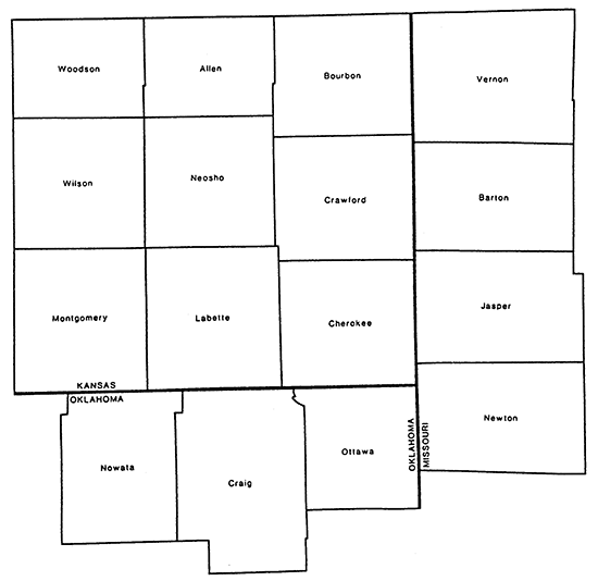
The area of investigation for this project was confined for the most part to nine counties in southeast Kansas: Cherokee, Crawford, Bourbon, Labette, Neosho, Allen, Montgomery, Wilson, and Woodson counties (Fig. 1). Some additional data was collected in adjoining areas of Missouri and Oklahoma for continuity. The extended study are in Missouri included portions or all of Vernon, Barton, Jasper, Newton, and McDonald counties and in Oklahoma included portions or all of Ottawa, Craig and Nowata counties.
Figure 1--Location of study area.
Groundwater investigations pertaining to the Lower Paleozoic aquifers in southeast Kansas and in the adjoining areas of Missouri and Oklahoma have been numerous. In the early 1940s Abernathy (1941) reported on the availability of groundwater from the Cambro-Ordovician and Mississippian aquifers in Bourbon, Crawford, Cherokee, and Labette counties in Kansas. This was a reconnaissance investigation containing data from scattered wells in southwest Missouri and southeast Kansas. Abernathy recognized the great variability of groundwater chemical quality in the Cambro-Ordovician aquifer within this region. Also, he reported on the drilling and testing of a new well for the Jayhawk Ordinance Plant (now the Gulf Oil Chemical Corporation) that penetrated the Cambro-Ordovician aquifer (Abernathy, 1943). Williams (1948) wrote a report on the possible contamination of public water supply wells finished in the Cambro-Ordovician caused by leakage of waters from the overlying Pennsylvanian or Mississippian aquifers into public supply wells at McCune, Cherokee, and Arma, Kansas. Later, Stramel (1957) conducted several pumping and recovery tests on wells used for public water supply by the City of Pittsburg to determine the hydraulic properties of the Cambro-Ordovician aquifer in the well field. He noted that static water levels in wells penetrating this aquifer had declined more than 100 feet since the drilling of the first well in the early 1880s. In Oklahoma Reed et al. (1955) reported on the results of a ground-water availability study in the Mississippian and Cambro-Ordovician aquifers in Ottawa County. They showed that at Miami, Oklahoma, static water level declines of approximately 400 feet have occurred in wells penetrating the deeper aquifers between 1905 and 1947. More recently, the u.s. Geological Survey and the Oklahoma Geological Survey (Marcher and Bingham, 1971) cooperatively produced from available data a hydrologic atlas of groundwater resources including those in the Lower Paleozoic for the Tulsa quadrangle in northeastern Oklahoma. Chenowith (1964a,b) produced maps of chloride concentration and the potentiometric surface for the Arbuckle Group in Kansas, Oklahoma, and southwestern Missouri using oil company data. In Missouri, Feder et al. (1969) wrote a report on groundwater availability and chemical quality for the Mississippian and Cambro-Ordovician aquifers in the Joplin area. Farther north, using available data, Frick (1980) examined the hydrogeology of the Lower Paleozoic aquifers in portions of Bourbon, Crawford, and Cherokee counties in southeast Kansas and Jasper, Barton, and Vernon counties in Missouri. Darr (1978) wrote a report on the geochemistry of groundwater in Bates, Vernon and Barton counties in Missouri. He collected and analyzed water samples from wells completed in Pennsylvanian, Mississippian, and Cambro-Ordovician aquifers in these counties. Recently, Hathaway and Macfarlane (1980) discussed spatial and temporal variations in the chemical quality of groundwater from the Lower Paleozoic aquifers in the Tri-State region.
The U.S. Geological Survey is presently conducting two regional geohydrologic investigations that pertain to the Lower Paleozoic aquifer system in Kansas. One study is a state-wide investigation of the feasibility of waste disposal by deep-well injection into the Cambro-Ordovician. Funding from this USGS study and from our investigation was used for the drilling of an observation well at Parsons, Kansas. The second study is the Central Midwest Regional Aquifer Systems Analysis (CM RASA); its goal is to develop an overall picture of the hydrogeology and water chemistry of all bedrock aquifers in Kansas and adjoining states that contain significant amounts of groundwater (Jorgensen and Signor, 1981).
This project was conducted in two stages when the emphasis of the investigation changed. The project was begun in Bourbon, Crawford and Cherokee counties in southeast Kansas and in adjoining areas of southwest Missouri and northeastern Oklahoma. Water samples were collected during spring and fall of 1979 and 1980 in an attempt to document short-term changes where groundwater from the Cambro-Ordovician aquifer is used for public water supply. Static water levels were also measured three times for the same purpose. Later the Kansas Geological Survey contracted with the Kansas Department of Health and Environment to do hydrogeology and groundwater chemical-quality work to the west in the more saline portions of the aquifer. For this second phase, each well was visited twice: once to collect a water sample and once to determine fluid levels.
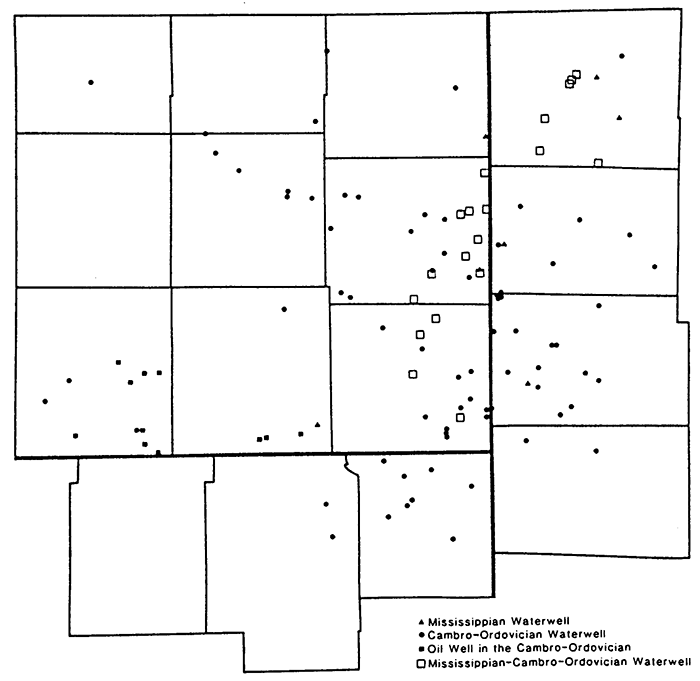
A literature search was conducted to collect from federal, state, and industry files all available data on Lower Paleozoic stratigraphy, well locations, groundwater chemical quality and geologic structure in southeast Kansas and adjoining areas (Fig. 2). Several trips were made to state agencies in Kansas, Missouri, and Oklahoma for this purpose. All data were examined for accuracy and those data found to be inaccurate or questionable were discarded. The rest of the data was plotted on base maps of southeast Kansas and surrounding areas. New data developed during the study were plotted on these maps as they became available. At the end of the project, the base maps were contoured to show various features of the subsurface groundwater flow or trends in groundwater chemical quality and graphs were constructed to illustrate small-scale features or specific relationships.
Figure 2--Locations of wells visited in southeast Kansas and adjoining areas.
Well cuttings were collected from several wells drilled during the course of this study. The cuttings were examined with a microscope and a log was prepared for the well. A portion of the cuttings was shipped to the Division of Geology and Land Survey, Missouri Department of Natural Resources, Rolla, Missouri, for stratigraphic interpretation using insoluble residues. The insoluble-residue log and the log prepared from examining the cuttings were used to interpret the characteristics of the formations penetrated by the well.
Several types of borehole geophysical logs were run on two wells drilled during the course of the investigation. At the Kansas Ord #1, a USGS-KGS monitoring well, dual-induction laterologs, borehole-compensated sonic logs, and compensated neutronformation density logs were produced by Schlumberger in hard copy and on tape. Later, temperature, spinner, and brine-injection flow logs were run by the USGS. At Crawford County Rural Water District #7, Well #2, a dual induction focused log and a compensated densilog were run by Dresser Atlas.
Water samples were collected from both water and oil wells penetrating the Lower Paleozoic aquifer in southeast Kansas and adjoining areas. Most of the freshwater wells were sampled more than once. Each of the oil-field water-supply wells (for secondary recovery) and oil wells was sampled once. Water samples were collected only from wells that had been pumped at least 15 minutes prior to collection. Oil field waters were collected from oil wells only after the oil in the oil/water mixture to separated from the water in a five-gallon separation tank. Temperature, pH, specific conductance, and hydrogen sulfide concentration were determined at the wellhead except at oil wells. Specific conductance was determined from oil field water samples after filtration to remove the oil. At each oil well only temperature and hydrogen sulfide concentration were determined. Bicarbonate determinations were performed daily at a field laboratory on samples from fresh-water wells. These samples were kept chilled between the time of collection and analysis.
The collected water samples were analyzed for selected constituents by the Geochemistry Section, Kansas Geological Survey. These included calcium, magnesium, sodium, potassium, strontium, bicarbonate, sulfate, and chloride, fluoride, nitrate, iron, boron, lithium, barium, manganese, bromide, and iodide. All of the water chemistry data, including specific conductance, were plotted on base maps of the area and contoured to show areal distribution patterns.
Several trips were made to the field to measure static fluid levels in water and oil wells penetrating Lower Paleozoic aquifers. Static water levels were determined in the water wells with a steel tape or an Echometer. Equivalent static water levels were determined in oil wells using the Echometer only. The static water level data were then plotted on base maps and contoured to show the potentiometric surface at various levels in the Lower Paleozoic.
Kansas Geological Survey, Geohydrology
Placed online Feb. 20, 2017
Comments to webadmin@kgs.ku.edu
The URL for this page is http://www.kgs.ku.edu/Hydro/Publications/1981/OFR81_16/index.html