Peter Scholle, New Mexico Bureau of Geology and Mineral Resources
and M. Lee Allison, Kansas Geological Survey
|
|
| Energy and Natural Resources Testimony by Peter Scholle, New Mexico Bureau of Geology and Mineral Resources and M. Lee Allison, Kansas Geological Survey |
|
Testimony Presented to the Senate Committee on Energy and Natural Resources, Subcommittee on Water and PowerHearing on Senate Bill 2773--The High Plains Aquifer Hydrogeologic Characterization, Mapping, Modeling and Monitoring Act. July 31, 2002
Expanded Testimony Mr. Chairman and Members of the Committee, my name is Peter Scholle, and I am the Director of the Bureau of Geology and Mineral Resources, the New Mexico State Geologist, and a member of the High Plains Aquifer Coalition. I am appearing today on the Coalition's behalf in support of Senate Bill 2773--The High Plains Aquifer Hydrogeologic Characterization, Mapping, Modeling and Monitoring Act. The Coalition is a joint effort between the geological surveys of the eight High Plains Aquifer states and the U.S. Geological Survey. The Coalition objective is to improve the geological characterization and understanding of the High Plains aquifer. With me is Lee Allison, the lead organizer of the Coalition, and the State Geologist and Director of the Kansas Geological Survey. We appreciate the invitation to appear before this Committee.
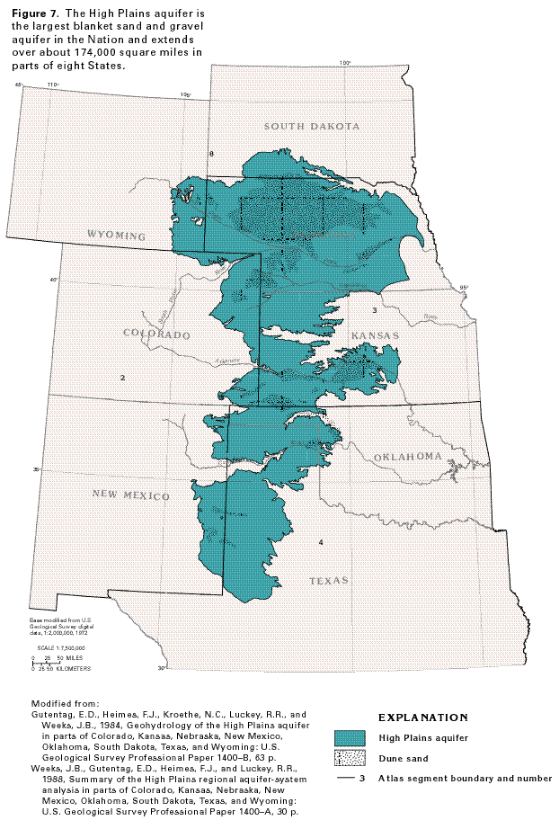
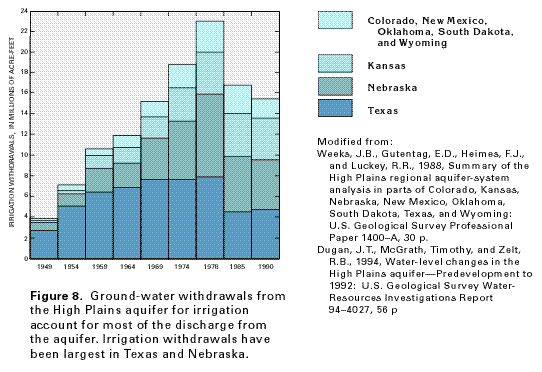
Introduction: A reliable source of water is essential to the well-being and livelihoods of people in the High Plains region where ground water is used for drinking water, ranching, farming, and other purposes. Many areas of the High Plains aquifer have experienced a dramatic depletion of this resource. Large-volume pumping from this aquifer has led to steadily declining water levels in the region, and the area faces several critical water-related issues. Let me begin with some facts about the aquifer. The High Plains aquifer is the most widespread blanket sand and gravel aquifer in the nation. It encompasses one of the major agricultural regions in the world and underlies 174,000 square miles, including parts of eight states--New Mexico, Texas, Oklahoma, Kansas, Colorado, Nebraska, Wyoming and South Dakota. (Figure 1) Approximately 2.3 million people live within the High Plains, and the aquifer supplies drinking water for 82 percent of them. Agriculture, however, represents both the dominant land and water use in the region (94 percent of groundwater withdrawals from the aquifer are for irrigation). The High Plains aquifer is the most intensely pumped aquifer in the United States, yielding about 30 percent of the nation's ground water used for irrigation. During 1995, total water use in the High Plains was estimated to be 19.9 billion gallons per day and, with the exception of the Platte River Valley of Nebraska, 92 percent of that need was met by aquifer water. Although High Plains dry-land farming is possible, availability of "water on demand" from the aquifer has made abundant, reliable crop yields a reality. As a result, the region accounts for about 19 percent of total US production of each wheat and cotton, 15 percent of our corn, and 3 percent of our sorghum. In addition, the region produces nearly 18 percent of US beef and is rapidly becoming a center for hog and dairy industries. Those numbers alone should elevate concern about the sustainability of the aquifer from a regional to a national level. Aquifer characterization: Aquifers are underground deposits containing permeable rock or sediments (silts, sands, and gravels) from which water can be pumped in usable quantities. Although the High Plains aquifer often is discussed as a single entity, it is a regional system composed of eight smaller units that are geologically similar and hydrologically connected--that is, water can move from one aquifer to the other. The aquifer is unconfined, that is, it is not confined under pressure below impermeable rocks as artesian water is. The aquifer consists of a hetereogeneous mixture of loose clays, silts, sands, and gravels that formed over millions of years by ancient river systems. The Ogallala Formation is the principal geologic unit, but the aquifer as a whole also includes deposits that are older and younger than the Ogallala. In some locations, the Ogallala Formation crops out at the surface, forming a naturally cemented rock layer called mortarbeds. Aquifer characteristics are determined in large part by geology. The High Plains aquifer is composed mainly of silt, sand, gravel, and clay-rock debris that washed off the face of the Rocky Mountains and other more local sources over the past several million years. The aquifer varies greatly from place to place: thick in some places, thin in others; permeable (able to transmit water easily) in some places, less so in others. Where the deposits are thick and permeable, water is easily removed and the aquifer can support large volumes of pumping for long periods. In most areas, this water is of good quality. Beneath the High Plains aquifer is much older, consolidated bedrock, usually limestone, sandstone, or shale. In some places this bedrock holds enough water to be called an aquifer, and it may be connected to the overlying aquifer. Some layers of the underlying bedrock contain saltwater; where these are directly connected to the High Plains aquifer, they pose a threat to water quality.
Water Resources in the High Plains Aquifer: Usable water in the High Plains aquifer is in the pore spaces between particles of sand and gravel. This water (called ground water) accumulated slowly--in some of the deeper parts of the aquifer, over tens of thousands of years. In the subsurface, water in the aquifer generally moves slowly from west to east, usually at the rate of tens of feet per year. Water volumes and use are measured in various ways. One measure is an acre-foot, or the amount of water necessary to cover an acre of ground (a parcel about the size of a football field) with a foot of water. An acre-foot equals 325,851 gallons of water. Another measure of ground water is saturated thickness. The saturated thickness of the High Plains aquifer is the vertical distance between the water table and the base of the aquifer. Saturated thickness is commonly measured in feet but "feet of saturated thickness" is not the same as feet of actual water. Only about 10 to 25 percent of the aquifer volume is pore space that can yield extractable water. Therefore, in an aquifer with 17 percent pore space, removing 1 acre-foot of water causes the water table to drop by about 6 feet. The saturated thickness of the aquifer can exceed 1,000 feet, but averages about 200 feet. Depth to water table ranges from 0 to 500 feet, with an average of about 100 feet. Much greater saturated thicknesses were common before the onset of large-scale irrigation. Groundwater can also be measured in terms of its availability: how much water can be removed by a well over short periods. Large volumes of water can be pumped rapidly (1,000 gallons or more per minute) from the High Plains aquifer in many locations. This contrasts withmany areas in the region, where wells generally produce smaller amounts (less than 100 gallons per minute). By way of comparison, a good household well produces 5 to 10 gallons per minute, although many household wells produce less.
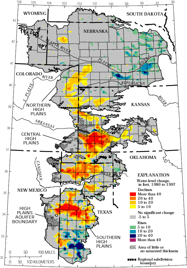
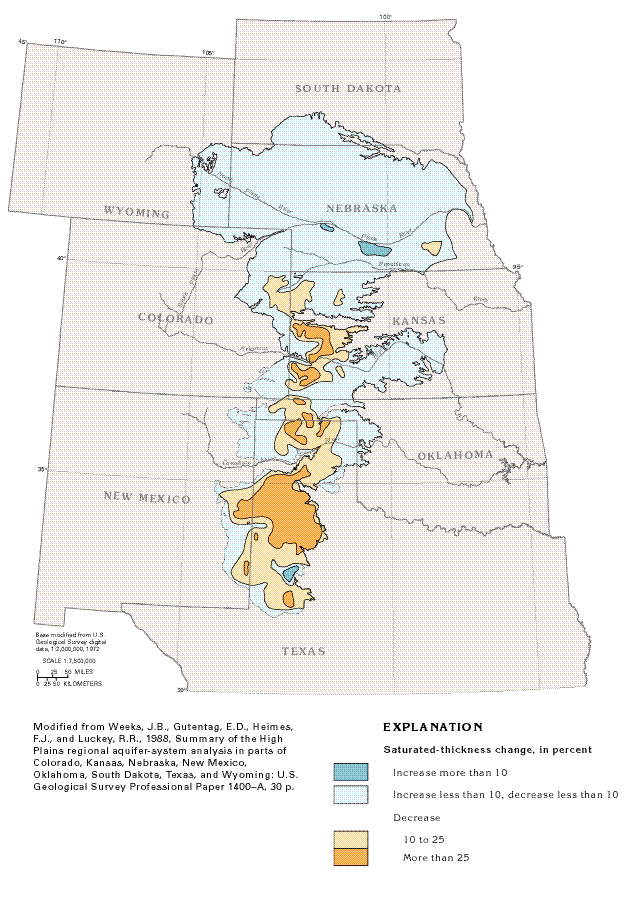
Recharge is the natural movement of water into an aquifer, usually from precipitation. Areas of increase can also be the result of increased recharge to the aquifer by one or more of the following factors: greater than normal precipitation; decreased withdrawals; or downward leakage of surface-water irrigation and water from unlined canals and reservoirs. The relatively low rainfall of the region limits aquifer recharge rates and thus provides a long-term limit on sustainable water use. The estimated average annual potential recharge from rainfall ranges from as little as 1/4th of an inch per year in the southwestern portion of the aquifer area to 6 inches in the northeastern portion. Where the aquifer is closer to the earth's surface, where soils are sandier, and precipitation amounts greater, recharge can be significant, as much as 4 to 6 inches per year. Withdrawals greatly exceeded recharge in many areas since intensive irrigation began in the 1940's. This has resulted in widespread water-level declines, especially in southern areas – more than 100 feet in parts of Kansas, New Mexico, Oklahoma and Texas. In some places, irrigation has become impossible or cost prohibitive because of such declines. From 1980 to 1997, the average water level in the aquifer fell 2.7 feet. (Figure 2 ) Aquifer water generally flows eastward and discharges naturally to streams and springs. Water may also be lost from the aquifer by evapotranspiration or through leakage into underlying rock units. However, pumping from the numerous irrigation wells is the number one cause of groundwater withdrawal. Decreases in saturated thickness of 10 percent or more result in a decrease in well yields and an increase in pumping costs because the pumps must lift the water from greater depths (Figures 3 & 4).
Water-level Declines in the Aquifer: Large-scale irrigation began in the High Plains in the late 1800's, with the use of ditches to divert water from rivers. As technology improved, groundwater became the major irrigation source because surface water (lakes, rivers, and streams) is relatively scarce in the region. With the advent of large-capacity pumps that were capable of drawing several hundred gallons of water per minute, people began to exploit that ground water. Using a technique called flood irrigation, water was pumped through long pipes or ditches along the edges of a field, then out onto rows of crops. In the 1950's and 1960's, technological developments led to a dramatic increase in large-scale pumping. In particular, center-pivot irrigation systems--large sprinklers that roll across the land on wheels--allowed people to irrigate uneven terrain, thus opening up large new areas for irrigation. These irrigation methods led to the cultivation of crops, such as corn, that could not previously be grown reliably in the area. For many years, people believed that the High Plains aquifer contained an inexhaustible amount of water. However, large-volume pumping (mostly for irrigation) eventually led to substantial declines in the water table, and people realized that the amount of water in the aquifer was finite and could be exhausted. Much of the Ogallala portion of the High Plains aquifer has declined since predevelopment, with some areas having declines of more than 60 percent.
When Will the Aquifer Run Dry?: Perhaps the most common and important question about the High Plains aquifer is: How much longer can it support large-scale pumping? It's a simple question with a complicated answer. First, the aquifer will probably be able to support small, domestic wells far into the future. With proper planning, most cities and towns should be able to provide for their water needs. Second, the future of agricultural use of the aquifer depends on a variety of factors, including the price of irrigated crops, the price and availability of energy (the deeper the water table, the more energy it takes to pump water), climate, and how the water is managed. Third, it is important to remember that the aquifer is not one consistent, homogeneous unit. Rather, it varies considerably from place to place. In places, the aquifer consists of less than 50 feet of saturated thickness and receives little recharge. In other places, the aquifer is far thicker or receives considerably more recharge. With those qualifications in mind, researchers have made projections about the aquifer, based on past trends in water-level declines. Obviously, the actual future use of water will be affected by commodity prices, energy prices, climate, and management policies. In addition, relatively little data are available for some parts of the aquifer, and projections are not practical in those areas. Assuming a saturated thickness of 30 feet as the minimum amount necessary to support large-scale pumping, researchers concluded that parts of the aquifer are effectively exhausted in some areas. Other parts of the aquifer are predicted to have a lifespan of less than 25 years, based on past decline trends. However, the biggest share of the aquifer would not be depleted for 50 to 200 years or longer. It is important to remember that these projections are based on past trends, and future changes could alter the actual depletion rate.
Where Do We Go From Here?: Individuals, governmental agencies, and private organizations are all attempting to address issues related to the High Plains aquifer. In addition, several new institutions have recently been proposed to deal with issues concerning the aquifer on a regional basis. Irrigators have implemented a number of techniques that have improved the efficiency with which they use water--using low-pressure application methods on center-pivot systems, for example, instead of spraying water high into the air. Among the more far-reaching proposals for extending the life of the aquifer is the idea of sustainable development. This is the concept of limiting the amount of water taken from the aquifer to no more than the amount of recharge, and perhaps less, depending on the impact on water quality and minimum streamflows. This level of use is the target of the safe-yield management policies currently in effect in some Groundwater Management Districts in the wetter or thicker parts of the High Plains aquifer. Adoption of a similar policy in other areas of the High Plains aquifer would require a substantial decrease in the amount of water currently used. This would have an impact on the type and amount of crops grown in the area and, in turn, on a variety of economic activities. Because many of the water rights in the High Plains aquifer were established long ago and thus may have priority, the implementation of sustainable-development approaches to water resources has potentially serious legal implications. Other methods for dealing with the High Plains aquifer are being proposed, discussed, and implemented. All are aimed at extending the life of this crucial resource.
High Plains Aquifer Coalition: Each state manages its water resources differently. The number of state and local water agencies and their duties vary dramatically among the eight High Plains states. None of the eight state geological surveys deal directly with groundwater management. State geological surveys provide scientific advice to their respective state and local management agencies. Some state surveys focus strictly on the geologic framework in which groundwater exists, others investigate both the geology and the hydrology of groundwater. Because the structure for conducting hydrogeologic research on the aquifer differs dramatically among states, both the existing knowledge base and ongoing aquifer research efforts vary substantially from state to state. Much of past research was limited by state expertise, budget allocations and cooperation among state agencies. To prevent future inconsistencies among state research efforts and to efficiently utilize existing research data, in June 2000, the geological surveys of the eight states that contain the High Plains aquifer formed the High Plains Aquifer Coalition, in alliance with the U.S. Geological Survey. Coalition members are Kansas Geological Survey, New Mexico Bureau of Geology and Mineral Resources, Nebraska Conservation and Survey Division, Texas Bureau of Economic Geology, Colorado Geological Survey, Oklahoma Geological Survey, South Dakota Geological Survey, Wyoming State Geological Survey, and U.S. Geological Survey.
The purpose of the Coalition is to cooperate in joint investigations and scientific exchanges concerning the earth sciences (including hydrology, geology, geochemistry, geochronology, geophysics, geotechnical and geological engineering and related investigations) on topics of mutual interest. This agreement was specifically undertaken to advance the understanding of the three-dimensional distribution, character, and nature of the sedimentary deposits that comprise the High Plains aquifer in the eight-state Mid-continent region. It recognizes that the distribution, withdrawal, and recharge of groundwater, and the interaction with surface waters is profoundly affected by the geology and the natural environment of the High Plains aquifer in all eight States--New Mexico, Texas, Oklahoma, Colorado, Kansas, Nebraska, South Dakota, and Wyoming--thereby establishing a commonality of interests among the Surveys and citizens of these states. The Geological Surveys agreed that reaching a fuller understanding of the three-dimensional framework and hydrogeology of the High Plains Aquifer is necessary to provide local and state policymakers with the earth-science information required to make wise decisions regarding urban and agricultural land use, the protection of aquifers and surface waters, and the environmental well being of the citizens of this geologically unique region. Research Needs: Through past research, we have learned that the aquifer consists of many sub-regions or smaller units. Past research also helped identify the need to focus future efforts on geological and hydrological characterization, mapping, modeling and monitoring of aquifer subunits. The eight state geological surveys and the U.S. Geological Survey, in consultation with state and local water agencies and groups, have agreed on the need for comprehensive understanding of the subsurface configuration and hydrogeology of the High Plains Aquifer. Improved knowledge in these areas will refine our understanding of the aquifer and provide better tools and strategies for long-term, coordinated aquifer management. The High Plains Aquifer Coalition is in the early stages of developing a cooperative regional strategic plan for scientific research and collaboration that will lead to a more detailed understanding of what research is required in the region. Major research questions in the High Plains aquifer include: rates and controls on recharge, relationships among saturated thickness, geologic character, and well yield, relationship among water levels, water use, and aquifer lifetime, impacts of climate changes, and appropriate scale and precision of data sets for new management approaches. Topical research areas that we anticipate to be addressed by this legislation include the following:
In addition to a possible increase in the density of data for adequate aquifer management the Coalition has identified a preliminary list of other data that would be needed to develop an aquifer management plan. These include:
Why the Bill is Important to the Region and the Nation: Extending the life of the High Plains aquifer is essential to the economic viability of the region because there are no realistic alternative water sources. Accurate data about aquifer variability and subunit characteristics will allow us to accurately determine current water levels, where and at what rates aquifer water moves, and the variables that impact water recharge rates in aquifer subunits. Knowledge of these factors will allow us to better predict future water levels and ultimately will lead to development of improved approaches for enhancing and extending the life of the aquifer and other factors useful for management purposes. Federal funds will expand existing capabilities and enhance the effects of ongoing state and local funding. Complementary funding will allow us to build regional databases and understanding of the aquifer. The bill enlists expertise from the U.S. Geological Survey not available at the state level and fosters better coordination with other groups within states and across state boundaries. . State and local water users, managers and regulators are increasingly demanding the types and quality of data needed to develop useful and reasonable water management programs. For example, in Kansas, local Groundwater Management Districts are requesting subunit characterization of the aquifer that requires a more sophisticated and regional understanding of the nature of the aquifer. Current resources for state and federal water agencies are insufficient to meet these increasingly demanding needs. Senate Bill 2773 establishes procedures to ensure that the research carried out is that most critical to water users and managers. The bill would require that broadly based state advisory groups concur with proposed studies; that peer review ensures the research is of the highest quality; that funds are awarded on merit; and that there is technical review of both federal and state activities. These procedures provide an unusually rigorous level of accountability. In conclusion, this bill is an important first step in a comprehensive program to extend the life of the aquifer. The bill will help ensure that the relevant science needed to address aquifer depletion is available so that we will have a better understanding of the resources of the High Plains aquifer and can ultimately lead to extending the life of the aquifer. We urge this Subcommittee to support Senate Bill 2773--The High Plains Aquifer Hydrogeologic Characterization, Mapping, Modeling and Monitoring Act. This concludes my testimony on behalf of the Coalition. We are submitting additional written testimony for your review. Thank you for your consideration. We would be happy to answer any questions that you may have.
Acknowledgements: Substantive parts of the above text were taken with permission from Buchanan and Buddemeier, 2001, and modified slightly for use here. Dana Woodbury of the Ogallala Aquifer Institute, Garden City, Kansas, assisted in the preparation of this testimony. References: Rex Buchanan and Robert Buddemeier, 2001. The High Plains Aquifer. Kansas Geological Survey, Public Information Circular 18, 6p. James Miller, 1999. USGS Ground Water Atlas for the United States. United States Geological Survey, Introduction and National Summary. V.L. McGuire, March 2001. Water-Level Changes in the High Plains Aquifer, 1980 to 1999. United States Geological Survey. Fact Sheet -029091. |
||||||
|
Figure 1--James Miller, 1999. USGS Ground Water Atlas for the United States. United States Geological Survey, Introduction and National Summary. http://capp.water.usgs.gov/gwa/index.html
|
|
Page updated Aug. 8, 2002 URL="http://www.kgs.ku.edu/HPAC/Testmony/scholle.html" Comments or suggestions to webadmin@kgs.ku.edu |