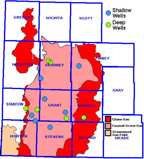

| Well | Operator | API | Location |
|---|---|---|---|
| Shankle 2-9 | Amoco Production Co. | 15-093-21250 | T23S, R37W, Sec. 9, NW SE SW |
| Mlp Scott A 1 | Oxy USA, Inc. | 15-067-21173 | T30S, R35W, Sec. 26W |
| Shrimplin Gas Unit 2HI | Amoco Production Co. | 15-055-21045 | T24S R33W, Sec. 7, N2 NW SE SW |
| Beaty Gas Unit 'E' 2 | Amoco Production Co. | 15-093-20111 | T25S R38W, Sec. 26, C S2 |
| Craft Gas Unit 3HI | Amoco Production Co. | 15-067-20652 | T28S R38W, Sec. 22, NE NE SW NW |
| STUART 3-34R | Pioneer Natural Resources | 15-067-21415 | T29S R35W, Sec. 34, W2 E2 NW |
| PAUL E PLUMMER 1 | ARCO Oil and Gas | 15-187-20437 | T29S R39W, Sec. 25, NE NW |
| Kendrick 23-1 | J.M. Huber Corp. | 15-187-20632 | T29S R41W, Sec. 23, E2 NW NE NW |
| Luke Gas Unit 4 | Amoco Production Co. | 15-187-20661 | T30S R39W, Sec. 8, NE NE SW SW |
| NEWBY 2-28R | Pioneer Natural Resources USA Inc. | 15-189-22225 | T31S R37W, Sec. 28, SW NE SW SW |
| Montgomery Gas Unit 3HI | Amoco Production Co. | 15-129-20844 | T31S R39W, Sec. 5, NE |
| Longwood Gas Unit 2 | Amoco Production Co. | 15-093-20815 | T23S R37W, Sec. 35, C NW |
| I.L. KING 1 | Amoco Production Co. | 15-081-20280 | T30S R33W, Sec. 13, C SW NE |
Kansas Geological Survey
Comments to webadmin@kgs.ku.edu
Updated Feb. 2002
URL = http://www.kgs.ku.edu/Hugoton/TypeLogs/index.html