Contents:
Introduction
Classification
A. Streamflow
Reliability
B. Water
Quality
Historic Achievement of Minimum Desirable Streamflows
(MDS)
Introduction: This section provides a survey of some of the water quantity (streamflow) and water quality (salinity) factors that influence the potential use of surface water to meet increasing water demand or possible future competition for presently available water. In the overall spirit of the triage approach, available data have been used to develop overview classifications of the regions (subbasins) in which surface water may be available under some conditions (the Streamflow Reliability section), and in which potential use might be limited by certain types of water quality considerations (salinity -- discussed in the Water Quality section). Because regulatory factors and time trends in the resource itself are both important considerations, an analysis of the historic achievement of Minimum Desirable Streamflow targets is included, and where they exist they are used in place of the absolute flow values to determine water availability.
The assessment is preliminary, and incomplete in some areas because data are not readily available. Streamflow reliability, for example, can be estimated in the "no data" subbasins, and confirmed on the basis of various types of information. This is a slower and more labor-intensive process, and one that probably should be undertaken only after the priorities of need for information are assessed. Similarly, although the Total Maximum Daily Load process has not yet worked through all of the state's basins in terms of water quality, initial estimates can be made and confirmed once there is some degree of consensus on the most important areas and issues.
Agency and stakeholder feedback on the issues of prioritization is solicited.
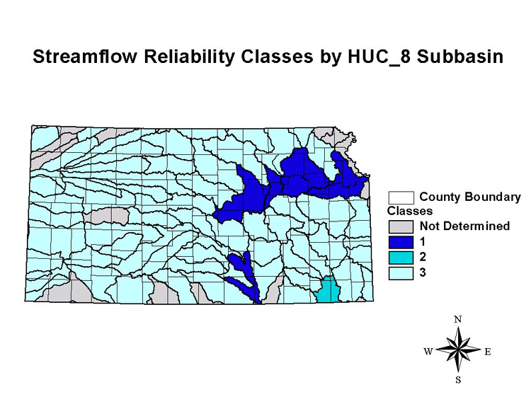
A. Streamflow Reliability: Streamflow represents a large quantity of water, but its temporal variability may make it unreliable for a sole supply. In this triage-based approach to potential surface-water availability, streamflows were classified by reliability at the HUC_8 subbasin level. Streamflow hydrographs were constructed from daily mean discharge data obtained from the USGS [http://waterdata.usgs.gov/nwis-w/KS/]. Classification was based on visual inspection of the hydrographs and associated data. Data from the past thirty years were compiled, however most emphasis was placed on data from the past ten years. The subbasin as a whole was assumed to be represented by the gages in or immediately downstream of the subbasin.
Streamflows in some basins are subject to Minimum Desirable Streamflows (MDS). In basins subject to MDS, the MDS values were used as a baseline for the classification. In other basins, absolute streamflow was used (baseline value = no flow).
Other than MDS, limitations on use imposed by regulations, contracts or water appropriations were not assessed. The classification is based on actual observed streamflows, and does not mean that flows are necessarily available for withdrawal, or practical to use.
The three classes of streamflow reliability were defined as follows:
Class 1-- streamflow essentially always 100 cfs greater than baseline (indicating continuous withdrawal may be feasible);
Class 2 -- streamflow essentially always 10 cfs but not 100 cfs greater than baseline (indicating withdrawals for supplements or conjunctive use may be feasible essentially every year); and
Class 3 -- flows below 10 cfs have
occurred at least two periods in the past ten years and flows less than
1 cfs have occurred (probably not a reliable water source).
The streamflow reliability classes for the HUC-8 subbasins are listed in Table 1 and mapped in Figure 1. Table 1 also lists in which basins the classification was influenced by MDS status, and notes those with no data or special conditions. The overwhelming majority of the basins fall into Class 3, suggesting that the potential for streamflow meeting future water demand is very limited in most basins, except where conjunctive use or off-line storage is available.
Note that in Class 3 basins, intermittent withdrawals for supplemental use may be feasible on many of the streams. However, another level of investigation is required to identify these basins. So many factors are involved in assessing the amount of streamflow potentially usable that it requires detailed site-specific analysis. An example is the Little Arkansas River, where a pilot study is underway to assess harvesting bank storage during high flows.
The only basins with year-around flows exceeding 100 cfs are the basins containing the Kansas, (Lower) Arkansas, and (Lower) Smoky Hill rivers. Flows have exceeded 10 cfs nearly all the time in the Middle Verdigris basin.
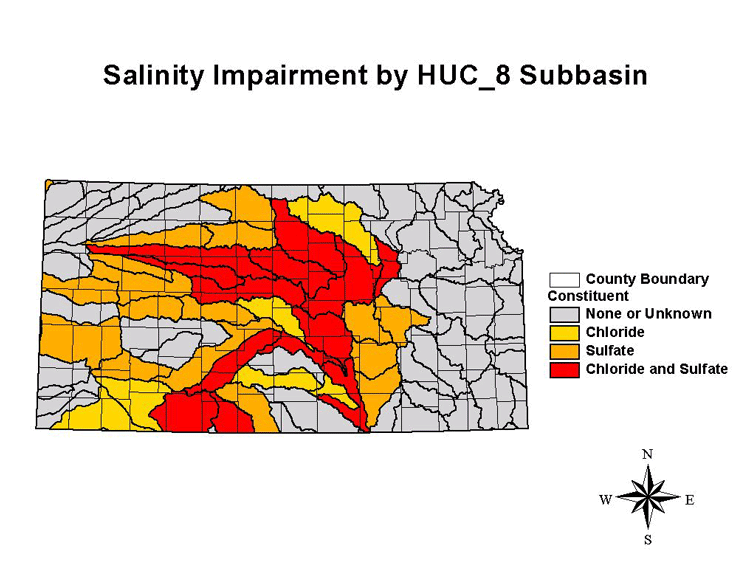
B. Water Quality: Water quality may be impacted by a number of constituents, some of which are easily treatable and some of which are not. The State Total Maximum Daily Loads (TMDL) program is in the process of identifying impacted stream segments. The 1998 303(d) list, compiled by the Kansas Department of Health and Environment (KDHE), was used to determine which stream segments are water-quality limited [or impaired] by salinity, which is less amenable to correction by treatment than many other constituents.
Basins with stream segments known to be impacted by salinity (primarily chloride and/or sulfate) are listed in Table 2 and shown in Figure 2. As Figure 2 indicates, much of the surface water in central and southwestern Kansas is water-quality limited by salinity.
The salinity classification does not distinguish between natural and anthropogenic sources. The Arkansas River contains high concentrations of sulfate where it enters Kansas from Colorado. Streams in other basins receive salinity from discharge of bedrock formations containing mineralized water. This is the primary source of salinity in much of central Kansas and in the Cimarron basin. The primary anthropogenic sources are oil brine, and salt-mine and water-softener wastes.
This assessment is necessarily incomplete, as TMDLs have only been developed for some of the States subbasins. In addition, the potential significance of contaminants other than salinity to water-supply development needs to be evaluated. Stream segments impaired by other contaminants are posted on the EPA website for the Kansas TMDL program; more detailed information and maps of the subbasins currently in the standard-setting process can be found at the KDHE TMDL site.
Historic Achievement of Minimum Desirable Streamflows (MDS)
Introduction: During the 1980 session, the Kansas Legislature established as an amendment to the Water Appropriation Act the concept of minimum desirable streamflows (MDS). Although the reasons for establishing minimum desirable streamflows and their chosen locations vary, the State Water Planning Act indicates that the main reasons for identification of MDS are to "preserve, maintain or enhance baseflows for instream water uses relative to water quality, fish, wildlife, aquatic life, recreation, general aesthetics and domestic uses and for the protection of existing water rights" (K.S.A. 82a-928 (i)).
Revisions of MDS were made to the Kansas Water Appropriation Act in 1984, 1985, 1987 and 1989. In 1984 MDS values were established on the Marais des Cygnes, Neosho, Cottonwood and Little Arkansas Rivers and given a priority date of April 12, 1984. This in essence gives the MDS values the force and effect of a water right. The 1984 legislation also established that any minimum desirable streamflow identified and established pursuant to law by July 1, 1990 would have a priority date of April 12, 1984. To date, MDS values have been established at 33 sites on 23 streams and rivers in the State.
Two methods are used to administer and protect minimum desirable streamflows. For sites that are located on regulated streams below reservoirs that contain State-owned storage, releases are made from the reservoirs to supplement low streamflow conditions. This includes fish spawning flows during April, May and June if the appropriate reservoirs are holding water in the flood pool.
The second method of MDS enforcement is administration of "junior" water rights, including surface water rights and hydraulically-connected alluvial groundwater rights, that are located above the respective MDS gage location. Thus, any such appropriation filed after April 12, 1984 ("junior" right) could be cut off during periods of low flow. No rights filed prior to April 12, 1984 ("senior" right) would be affected.
The goal of minimum desirable streamflows is not to keep streams flowing through all climatic conditions. Since the main remedies for low flow under the MDS process are either releases from reservoirs or administration of "junior" water rights, MDS does not address severely dry conditions on unregulated streams or extended droughts on regulated streams. The purpose of minimum desirable streamflows is to protect flow from depleted conditions as a result of extensive water appropriation.
MDS Values and Administration Areas: Established minimum desirable streamflows are listed in Table 3a, which includes the USGS gaging stations where flows are monitored. Spawning flows for fisheries on regulated streams are presented in Table 3b. The USGS gages used to monitor streamflows and the stream segments potentially subject to MDS administration are shown in Figure 3. Surface water rights on the highlighted stream segments and ground water rights in the alluvial aquifers along these stream segments are potentially subject to MDS administration.
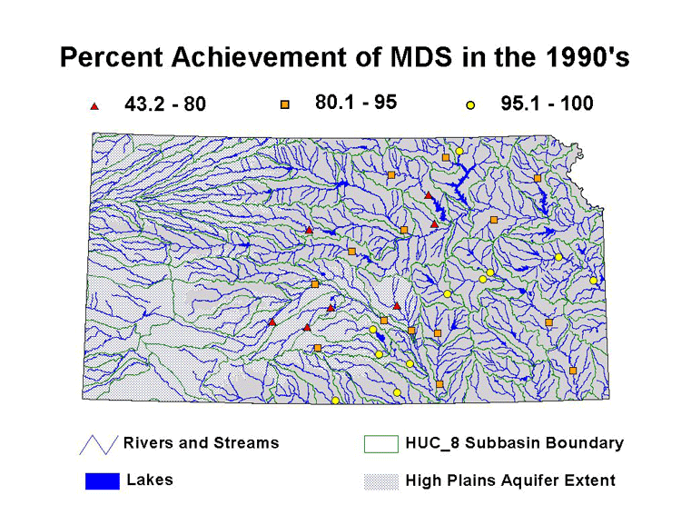
Achievement of MDS: Daily mean discharge data for the past 30 years were examined and compared with MDS values to assess historic achievement of MDS. Discharge data were obtained from the USGS website [http://waterdata.usgs.gov/nwis-w/KS/]. The data were separated into ten-year blocks representing the 1970s, the 1980s, and the 1990s in order to assess temporal variation. Percent achievement for each of the ten-year intervals is tabulated in Table 4, which is sorted by percent achievement in the 1990s. At 7 of the 33 sites, MDS were achieved less than 80 percent of the time; at 14 sites MDS were achieved between 80 and 95 percent of the time; and at the remaining 12 sites MDS were achieved more than 95 percent of the time. The locations of the sites in each of these three categories are shown in Figure 4. The extent of the High Plains aquifer and HUC_8 subbasin boundaries are also shown for reference.
Hydrographs showing the daily mean streamflows and the MDS criteria are available for viewing by clicking on the appropriate gage listing in Table 4. Because streamflows range over orders of magnitude, it is necessary to use a log scale to plot discharge on the hydrographs. Note that zero values do not plot on a log scale. For example, the apparent lack of data on the Arkansas River at Kinsley (station 07140000) in parts of 1994 and 1995 actually represents no flow.
As Table 4 indicates, achievement of MDS was lower in the 1990s compared to the 1970s at most sites despite the wet weather during the mid-1990s. This paralleled the trend of generally lower median streamflows in the state in the 1990s. However, flows on many streams increased substantially during the mid-1990s.
Back to Directory
Funded (in part) by the Kansas Water Plan Fund