P. A. Macfarlane, G. M. Misgna, R. W. Buddemeier
Introduction: This section addresses the potential of ground-water resources to meet future water demand and/or avert competition for existing water resources. Aquifer identification and assessment were undertaken in the context of public water supply demand evaluation, as was the streamflow assessment. Under discussion in this section are the ground-water resources of central and eastern Kansas. These areas have not been identified and reviewed in the earlier discussions of the High Plains and other hydraulically connected aquifers in that region.
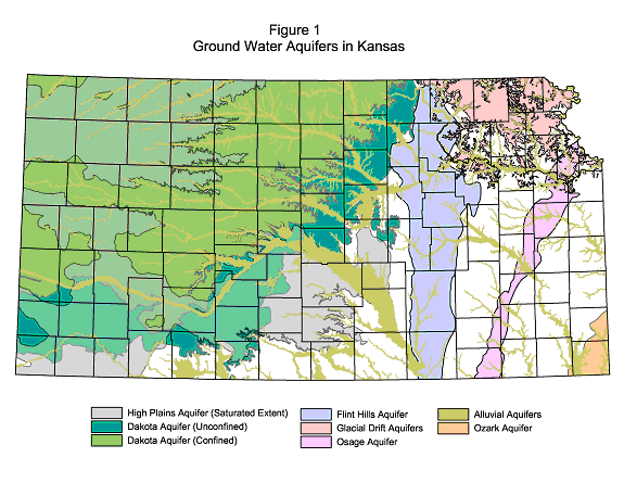
The aquifers identified in this section are: the Glacial Drift aquifer, Ozark aquifer system, Osage Cuestas aquifer system, and the Flint Hills aquifer. These are shown on the map in Figure 1. The present version of this map shows only the approximate areal extent of these central and eastern Kansas aquifers. Much less is known about the nature of these potential sources of supply than the High Plains aquifer because, with few exceptions, regional ground-water resource evaluations have not been performed in most of eastern and central Kansas. Consequently, estimates of recharge or sustainable yield based on current data are unreliable. Nevertheless, the overall objective of this section is to identify the extent and provide an initial estimate of the quantity of fresh ground water that could potentially be available from these sources of supply.
Not considered in this discussion are the ground-water resources in the Dakota aquifer and the alluvial aquifers. The alluvial aquifers are not considered here because their water resources are in general indistinguishable from the streamflow in their associated stream channels, and it is likely that the maintenance of streamflow will in most cases be the factor limiting both direct stream diversion and pumping from the alluvium (see In-Stream Water Resources and Historic Achievement of Minimum Desirable Streamflows section). If the initial analysis suggests that stream baseflows are not a limiting factor in an area in need of additional water resources, the specific system can be revisited in the next stage of analysis. The Dakota aquifer has been extensively investigated and described in the Dakota Aquifer Program of the Kansas Geological Survey (KGS). As a result, its further analysis was given a lower priority for this project. An analysis of the water-resources potential of this aquifer system is forthcoming and will be integrated into this study as it becomes available.
Methods: The extents of the Glacial Drift and the freshwater part of the Ozark aquifer system were downloaded as GIS coverages from Data Analaysis and Support Center, KGS. The extents of the Flint Hills aquifer and the Osage Cuestas aquifer systems have not previously been mapped in detail. An initial map estimate of extent was created using the 1:500,000 scale map of Kansas surface geology (KGS Map M-1). The available eastern and central Kansas geology and ground-water resources county reports were used to identify water-bearing formations. The freshwater-bearing formations included in the Flint Hills aquifer are the limestones of the Permian, Council Grove, and Chase groups. In the Osage Cuestas aquifer system, the sandstones of the Pennsylvanian Lawrence and Stranger are the water-bearing formations.
The freshwater part of the Osage Cuestas aquifer system is partly confined and partly unconfined. Where sandstones crop out at the surface, the aquifer is considered unconfined, but where overlying geologic units are present, it is considered confined. The freshwater part of the Flint Hills aquifer is assumed to be unconfined throughout its extent. The Ozark aquifer system is mostly confined except for the extreme southeast corner of Cherokee Co, where the uppermost units that form this aquifer crop out at the surface. In northeast Kansas, the Glacial Drift aquifer is considered an unconfined aquifer.
Estimation of the total volume of fresh ground water in storage is not straightforward for any of these aquifers/aquifer systems, because not all of the included lithologies are capable of yielding water at economically feasible rates. Also, near the limits of their extent, the permeable units are usually only thinly saturated. To estimate the volume of fresh ground water in storage for each aquifer/aquifer system, an average total thickness of permeable freshwater-bearing strata was assumed over its extent. The total saturated volume of the aquifer is calculated using the formula:
Total volume of saturated deposits (AF) = Areal extent of the saturated deposits (Acres) x Saturated thickness (ft)
For the unconfined Osage Cuestas aquifer system, saturated thickness was estimated to be 50% of the total thickness of permeable units. Where confined, the saturated thickness of the Osage was taken as the total thickness of the permeable units. Lacking detailed subsurface information on the average sandstone thickness where the aquifer is confined, an estimate of 50 ft was used in the calculations for water in storage. In the case of the Flint Hills aquifer, an average saturated thickness of 40 ft was assumed. Typically, the water source for most domestic and stock wells using the Flint Hills aquifer includes about 30-50 ft of limestone. For the Glacial drift aquifer, the US Geological Survey coverages of bedrock and potentiometric surface elevation were used to calculate and map saturated thickness. In the case of the Ozark aquifer system, the freshwater part is bounded by a vertical and lateral transition from fresh to saline water. In the upper part of the confined aquifer the thickness of the freshwater portion thins from east to west across Crawford and Cherokee counties in southeast Kansas. As an initial estimate, an average thickness of 300 ft of freshwater aquifer was assumed over its lateral extent.
The porosity is the proportion of pore or void space in the rock or sediment relative to the rock or sediment bulk volume. When the rock or sediment is fully saturated, all of the pores or voids are filled with water. The specific yield is the volume of water that will drain from a saturated porous medium under gravity. The amount that will drain from a porous medium is normally somewhat less than what is present in the pores. The volume of ground water that can be extracted from an aquifer is calculated using the formula:
Volume of extractable ground water (AF) = Total volume of saturated deposits (AF) x Specific yield
The reduction in volume extracted is because some of the water is held in the pores by capillary forces. Sand and sandstone specific yield were conservatively estimated to be 15%. Limestone specific yield was also assumed to be 15%.
Table 1 lists the ground water in storage for the Osage Cuestas aquifer system and the Flint Hills and the Glacial Drift aquifers by county. The total water amount of fresh water in storage in the Ozark aquifer is estimated to be 19,575,000 AF.
Recharge: For the Glacial drift and Flint Hills aquifers and the unconfined portion of the Osage Cuestas aquifer system, recharge estimates were based on the US Geological Surveys regional recharge map used in the High Plains Aquifer Evaluation. GIS coverages of the aquifer extent and the annual recharge rate were overlain, and the volume of recharge for each unconfined aquifer was calculated county by county. The results of this calculation are given in Table 1. An initial estimate of lateral flow to the Kansas Ozark aquifer system from adjacent areas of Missouri resulted in a value of 6,300 AF/yr. It was assumed that the confined portion of the Osage Cuestas aquifer system receives no significant recharge from the surface other than that from the unconfined aquifer.
Table 1. Ground water in storage and annual recharge to the Osage Cuestas aquifer system and the Flint Hills aquifer estimated to the nearest thousand acre-ft (AF).
|
|
|
|
|
|
|
|
|
|
| Anderson | Osage Cuestas |
341,000
|
22,000
|
Johnson | Osage Cuestas
Glacial Drift |
127,000
20,000 |
6,000
7,000 |
|
| Atchison | Glacial Drift |
1,420,000
|
76,000
|
Leavenworth | Osage Cuestas
Glacial Drift |
1,403,000
132,000 |
41,000
36,000 |
|
| Brown | Glacial Drift |
785,000
|
101,000
|
Lyon | Flint Hills |
112,000
|
8,000
|
|
| Butler | Flint Hills |
4,238,000
|
234,000
|
Marion | Flint Hills |
1,651,000
|
86,000
|
|
| Chase | Flint Hills |
2,045,000
|
122,000
|
Marshall | Flint Hills
Glacial Drift |
1,057,000
2,120,000 |
60,000
85,000 |
|
| Chautaqua | Osage Cuestas |
1,378,000
|
54,000
|
Miami | Osage Cuestas |
2,000
|
0
|
|
| Clay | Flint Hills |
1,358,000
|
53,000
|
Montgomery | Osage Cuestas |
92,000
|
5,000
|
|
| Coffey | Osage Cuestas |
1,221,000
|
27,000
|
Morris | Flint Hills |
2,313,000
|
135,000
|
|
| Cowley | Flint Hills |
2,561,000
|
132,000
|
Nemaha | Glacial Drift |
5,620,000
|
138,000
|
|
| Dickinson | Flint Hills |
1,505,000
|
76,000
|
Osage | Osage Cuestas |
478,000
|
4,000
|
|
| Doniphan | Glacial Drift |
991,000
|
72,000
|
Pottawatomie | Flint Hills
Glacial Drift |
800,000
36,000 |
40,000
7,000 |
|
| Douglas | Osage Cuestas
Glacial Drift |
1,259,000
23,000 |
58,000
8,000 |
Riley | Flint Hills
Glacial Drift |
1,673,000
28,000 |
107,000
2,000 |
|
| Elk | Osage Cuestas |
718,000
|
26,000
|
Shawnee | Glacial Drift |
76,000
|
15,000
|
|
| Franklin | Osage Cuestas |
1,997,000
|
80,000
|
Wabaunsee | Flint Hills
Glacial Drift |
786,000
8,000 |
64,500
2,000 |
|
| Geary | Flint Hills |
1,431,000
|
94,000
|
Washington | Flint Hills
Glacial Drift |
743,000
15,000 |
44,000
3,000 |
|
| Greenwood | Osage Cuestas |
198,000
|
5,000
|
Wilson | Osage Cuestas |
531,000
|
28,000
|
|
| Jackson | Glacial Drift |
982,000
|
68,000
|
Woodson | Osage Cuestas |
680,000
|
32,000
|
|
| Jefferson | Osage Cuestas
Glacial Drift |
102,000
92,000 |
1,000
34,000 |
Wyandotte | Osage Cuestas
Glacial Drift |
66,000
94,000 |
1,000
18,000 |
|
| Johnson | Osage Cuestas
Glacial Drift |
127,000
20,000 |
6,000
7,000 |
Sustainable yield: Sustainable yield is difficult to estimate because very little is known of the aquifer hydrologic properties or the response of these eastern and central Kansas aquifers to pumping. In some cases where development has been low, the estimated recharge rate may exceed the actual sustainable recovery by a substantial amount. More accurate estimates will require aquifer by aquifer assessment at the local level.
Results: Based on the current analysis and the history of experience with the aquifer systems, few of the eastern/central Kansas aquifers have sustainable yield potentials comparable to the High Plains aquifer. In southeast Kansas and in the adjacent areas of Missouri and Oklahoma, the Ozark aquifer system has been a public water supply and source of water for the processing of lead and zinc ores for more than a century. From the available data, it is believed that water levels in this confined aquifer have declined approximately 100 ft over this time period due to pumping. This suggests that the Ozark may not be able to sustain significant additional development. The Glacial Drift aquifer, especially where the deposits are thicker and more permeable, is potentially productive, and in that area a significant number of ground-water rights are already in place. The Osage and Flint Hills systems are most appropriate for domestic and stock wells, and other relatively isolated, low-volume uses. Water quality is marginal in the deeper parts of each of these aquifers, except for the Glacial Drift.
Such aquifers can, however, play a role in a conjunctive-use approach to meeting overall water needs by providing short-term backup sources for small to medium sized suppliers in drought situations, or lower-quality water for blending to stretch a marginal supply. The combination of unreliable streamflows and a marginal aquifer system might be exploited by recharge enhancement (current testing on the Little Arkansas River) to ensure an improved conjunctive-use supply.
Further Work: This initial overview sets the stage for identifying the overlaps of water need or demand and the potential supplies of ground water and/or surface water. Consistent with the 'triage' approach, further efforts should be focused on analysis in those areas where the need is significant and the pay-off potential-- in the form of improved or expanded water supply -- is greatest.
Back to Directory
Funded (in part) by the Kansas Water Plan Fund