J. A. Schloss
Boldface links are to other atlas sections; italic items are linked to glossary definitions.
This section describes the data sources used to derive estimates of the elevation of the bedrock underlying the High Plains aquifer in Kansas, and gives an overview of the data-processing methods used to combine these data into a three-dimensional surface that was used to generate the estimates.
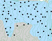
This figure shows a sample of the contours of the base of the High Plains aquifer used as input to the bedrock surface. These contours were produced by the U.S. Geological Survey and are the primary source of input data to the estimates of bedrock elevation. The light blue areas in the figure are within the saturated portion of the aquifer and the grey areas are defined as thinly or non-saturated. These distinctions come from another data layer produced by the USGS that delineates the extent of the High Plains aquifer . This layer defining the extent of the aquifer is used throughout the entire set of atlas pages.
To include as much information as possible, data were added from the KGS oracle database for all wells that had a value for depth to bedrock. Becuase the contours describe the base of the aquifer in terms of altitude instead of depth, the altitude of the bedrock surface at each well was calculated by subtracting the depth to bedrock from the altitude of the land surface. These points serve as a secondary source of input to the estimates of bedrock elevation.
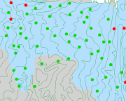
To honor the locations of the contours and points as much as possible, the bedrock data at the points were evaluated with respect to the contours, and some points were found to be in disagreement with the contours. All points were then flagged to be included or excluded from the surface model. In this figure, those colored green were used and those in red were ignored.
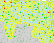
Once the input features were prepared, they were combined to create a model of the bedrock surface that would best honor the data from both sources. This image illustrates the density of the surface model (shown in yellow) that was created and how it "connects" to every contour line and every included point.
Funded (in part) by the Kansas Water Plan Fund