Kansas Geological Survey, Open-file Report 2004-13
by Richard D. Miller, Theresa R. Rademacker, David R. Laflen, Jamie L. Lambrecht, Joe M. Anderson, and Mary C. Brohammer
KGS Open-file Report 2004-13
Feb. 12, 2004
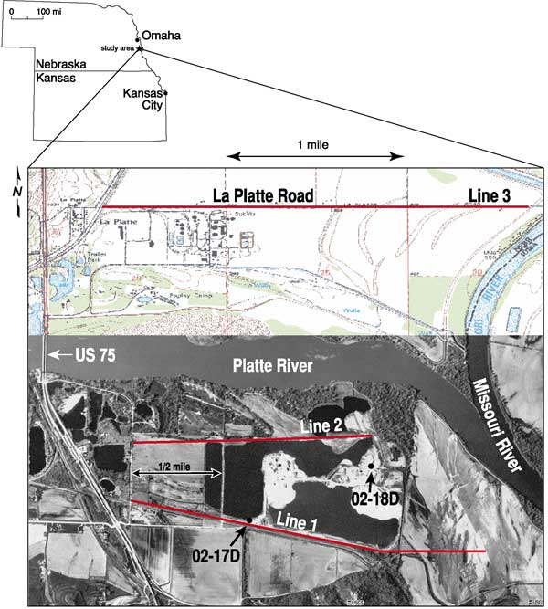
High-resolution seismic-reflection data allowed delineation of complex structural features associated with multiple episodes of faulting, uplift, and erosion beneath the Lyman-Richey Sand and Gravel Plant #8 located at the northern extreme of the Nemaha Ridge and Humboldt fault system in east-central Nebraska immediately north of Plattsmouth, Nebraska, in Cass County. The three 2-D seismic profiles that comprise this study imaged the features responsible for a 400+ ft (125+ m) discrepancy in the interpreted top of the Mississippian in two boreholes located less than three-quarters of a kilometer apart (Figure 1). A relatively narrow uplift feature, bounded by a large zone of faulting on the west and a series of normal fault blocks stepping down to the east, defines a more than 1625-ft- (500-m)-wide structurally altered area clearly responsible for the vastly different rocks retrieved from the two coreholes.
Figure 1. Site map with proposed lines along the north and south property boundaries of the Lyman-Richey Plant #8.
This generally north/south-trending, complex structural zone, regionally consistent with the northern extreme of the Nemaha Ridge/Humboldt fault system and strike change in the Midcontinent Geophysical Anomaly (MGA) can be seismically correlated from the southern boundary of the Lyman-Richey Plant, across the Platte River to La Platte Road. For the seismic data to correlate across the Platte River, a major right-lateral strike-slip (wrench) fault with a strike approximately parallel to the three seismic profiles and a slip component of approximately 1 km must be present between line 2 (northern boundary) and line 3 (La Platte Road). Considering the geologic setting and structural complexity of both the basement and overlying Paleozoic rocks in this area, a strike-slip fault is consistent with the subsurface data and provides a reasonable explanation for the regionally unique meander pattern of the modern Platte River valley. Confidence in the location of and displacement along this strike-slip fault is based on the interpretation of a locally northwest-plunging anticline clearly evident on all three seismic lines. Extrapolating the hinge of the fold north-northwest along its strike, the only possible structural geometry that fits the current orientation and location of this anticline requires approximately 1 km of right-lateral movement between lines 2 and 3. With the plunging nature of the anticline, it is not possible to confidently distinguish if and how much dip-slip component exists and, therefore, none is interpreted along this fault plane.
From basement and lower Paleozoic studies of eastern Nebraska, general trends in faulting and basement lithology appear to be predominantly northeasterly (Carlson, 1967; Lidiak, 1972). Immediately south and west of this site (a distance of less than a few kilometers), major changes in both basement composition and density of structural features have been interpreted from well and regional geophysical studies. Faults and folds interpreted on seismic data from this study--and inferred from line-to-line correlations--which at first glance strike north to north-west, appear to be somewhat contradictory to documented regional trends. However, this apparent discrepancy is easily explained by placing a right-lateral wrench fault beneath the Platte River valley, thereby providing a stress/strain environment that supports localized block rotation and is consistent with the seismically-defined strike of the anticline.
Structures associated with the uplift as interpreted on these seismic data are consistent with those seen on similar studies associated with the Nemaha Ridge further south in Kansas. Large offset and rotated blocks controlled by relatively small displacement, normal faults make up zones accounting for as much as 400 ft (150 m) of uplift at this site. Unfortunately the two southern lines (1 and 2) did not extend east far enough to image rocks that have not been altered in some way by this uplift feature and therefore it is not possible to confidently determine the overall dimensions of the anticline. Borehole 02-18D was drilled directly into an area with an abbreviated or possibly missing Mississippian section. Correlating rocks encountered in 02-18D with 02-17D is complicated and may not be possible for the entire section due to the complexity of the structures each appears to be sampling. An apparent relationship (possibly correlation) between minor faults interpreted on the west flank of the anticline is strong evidence supporting longitudinal faulting. This interpretation is consistent with those made by researchers studying features associated with the Nemaha Ridge in Kansas (Berendsen and Blair, 1995; Gay, 1999).
Considering the highly altered nature of the subsurface in this area, correlating geology observed in boreholes to reflections on seismic lines is done only in a very general way. A combination of data quality and highly variable reflection geometries observed on seismic data permit only general correlations of borehole interpretations from 02-17D to seismic line 1. The generalized geology from 02-17D is the basis for reflection-to-reflector matching on these seismic data. With borehole 02-18D located in an area defined by large normal fault blocks and offset off-line more than 200 m from line 2, it is not reasonable to attempt matching reflections on line 2 with potential reflectors identified in 02-18D. To our knowledge, borehole interpretations to date have not clearly determined whether the boring 02-18D encountered any Mississippian rocks at all. It is possible that no Mississippian rocks were penetrated at all and that the Devonian might be unconformably in contact with the Pennsylvanian. With enhanced analysis of these two cores, it will be possible to provide a more conclusive interpretation of the rock types observed on the seismic data.
Associated with the major features interpreted and inferred from the seismic sections are line-specific structures difficult to confidently correlate from line to line. While they are not particularly significant to the overall geology of this area, they would be devastating to underground mining activities. Small offset (<10 m) faults and folds with only minor curvatures (changes in layer elevation of 10 or so ft [a few meters] over distances of 325 ft [100 m]) interpreted on the flanks of the anticline have little or no effect on the overall quality or quantity of minable limestone but they do represent major obstacles to the mining process. Several normal faults, generally bounding minor folds, are evident within the trough on the western flank of the anticline. Bore-hole 02-17D penetrates a competent, thick Mississippian limestone section within this zone of folds and faults on the western flank. Therefore, the rock analysis is good, but volumetrically, mining from this point to near the western property boundary would be problematic due to abrupt lateral variations in rock elevations and possibly water associated with faults and folds.
An unusual and somewhat troubling drop in signal-to-noise ratio spanning about a half-kilometer dominates the western end of line 3. There seems to be two possible explanations for this feature: it is either a major basement structure, which could be interpreted as either an uplift (ridge) or major fault zone (reflections have been correlated across the feature, but with the limited amount of high-quality data on the western end of the seismic profile it is not possible to say those correlations are made with high confidence), or alternately this extreme drop in signal-to-noise ratio could be related to an area of high seismic-energy attenuation associated with a recent river meander that has silted full, or simply changes in the near-surface soils. This feature is not observed on either line south of the river, but it could be a portion of the Midcontinent Rift suggested to be following US 75 highway, offset to the east by the Platte River fault. It is possible this chaotic zone is the Humboldt fault previously mapped several kilometers west of this site (Carlson, 1967; Lidiak, 1972). Considering how high up in the section the data appears disturbed by this feature, if it is tectonic in origin then it was active well into the Late Pennsylvanian and seismic data provides no evidence to suggest it has not been active in the Quaternary.
Minability of Mississippian limestones in this area is likely greatest north and northeast of La Platte Road and east of the Lyman-Richey Plant #8 property line. Assuming rock quality, from a mining perspective, is relatively consistent in this general area (~10 km2), the seismic data suggest acceptable layer thicknesses and lateral continuity exist along the western and northwestern property boundaries of the Lyman-Richey Plant and to a greater extent north of La Platte Road. Based on the seismic data and what is assumed to be understood about the geology, if the uplift feature interpreted on line 3 has a strike and plunge consistent with interpretations of lines 1 and 2, then several square kilometers of good, minable rock is likely present immediately north and east of line 3 and along the eastern extreme of line 3. Any underground mining beneath the Lyman-Richey plant would need to concentrate at the far western end of the property or under the extreme east boundary and into the Schilling State Wildlife Area. It is not known how far west or east the very uniform, undisturbed Mississippian section extends beyond the property boundaries. If the chaotic zone interpreted on the western end of line 3 has been offset in a fashion similar to the anticline, then it is likely this same chaotic data area will be encountered less than a half-kilometer west of the western property boundary.
The primary goal of this study was to map the uppermost Mississippian limestone and the basal Pennsylvanian contact. Detailed mapping of this contact was critical for a reasonable description of the feature and determination of the most likely structural process that produced the feature responsible for the apparent inconsistency between coreholes 02-17D and 02-18D. Of secondary interest was the delineation of any thin chert, quartz, and shale stringers that might be present within the massive (over 10-ft-thick) Mississippian limestone encountered in hole 02-17D around 650 ft (200 m) below the ground surface. With the MGA--also called the Midcontinent Rift--and the Humboldt fault immediately west of the study area, and the northern edge of the Nemaha Ridge immediately south of the study area, extreme structural and depositional features were known to be locally possible. The primary objective was accomplished and, considering the complexity and short wavelength nature of the structures and associated movement, the geologic setting of this ~6 mile2 (~10 km2) study area is, in general, reasonably well described and consistent with all drilling and published literature. Unfortunately, the data quality was not sufficient to tackle the secondary objective: delineating stringers of chert, quartz, and shale within the Mississippian limestone of interest.
As proposed the project consisted of a testing and production phase. The testing phase required an initial trip to evaluate the effectiveness of impulsive sources along a portion of the southern property boundary suspected to possess average near-surface conditions. Based on that testing, the acquisition equipment and field design were modified to include an IVI minivib. A third line was added north of the Platte River after preliminary analysis of the two originally proposed lines showed a major structure beneath the Lyman-Richey property. Data processing concluded with the production of CMP stacked sections representative of an earth cross section. Interpretations focused on a strong reflecting event located at a time-depth approximately equivalent to the expected base of the massive Mississippian limestone targeted by this study.
Seismic images and the resulting geologic interpretations of those seismic images are optimized for the interval between the base of the Mississippian limestone of interest and the lower several hundred feet (hundred or so meters) of the Pennsylvanian section in this area. This optimization required a high degree of confidence correlating the high-resolution reflection data and existing ground truth (borings 02-17D and 02-18D).
To read these files, you will need the Acrobat PDF Reader, available free from Adobe.
Kansas Geological Survey, Geophysics
Placed online Feb. 9, 2006
Comments to webadmin@kgs.ku.edu
The URL for this page is http://www.kgs.ku.edu/Geophysics/OFR/2004/OFR04_13/index.html