Pottawatomie County
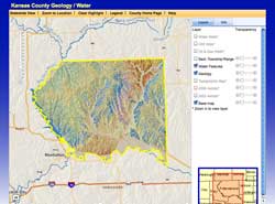
Interactive Map
Start Pottawatomie County viewer Pop-up window blockers will interfere with the operation of the mapping system. Please turn them off or configure them to allow pop-ups from kgs.ku.edu servers. |
|
Search Data by T-R-S
Other Resources
- Pottawatomie County General Stratigraphy
- Bibliography
- WWC5 Water Well Database
- Oil and Gas Wells
- KDOT's Project Information Portal for Northeast Kansas
- KGS' Geologic Map of Pottawatomie County
- U.S. Geological Survey's 1959 bulletin on resources of Pottawatomie County
- Tests on construction materials of Pottawatomie County